
Written by: Michael Gourlie, Government Records Archivist, Provincial Archives of Alberta
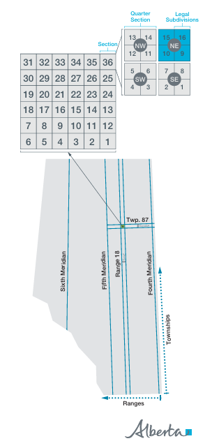
Township maps are a popular research source at the Provincial Archives of Alberta (PAA). An outcome of the Dominion Lands Surveys beginning in 1881 that captured most of what is now Alberta, the township maps document a grid system using meridians, ranges, townships and sections established by federal surveyors. Known as the Alberta Township System (ATS), this grid forms the basis of legal land descriptions used for Alberta land titles to the present day.
The original township maps were subsequently published in several editions, with the published maps used for a variety of operational purposes. They acted as a template or index for various offices to identify land uses for programs such as grazing leases, timber berths, mineral leases, land grants and homestead applicants. They also provided a standardized perspective to administer and oversee land use.
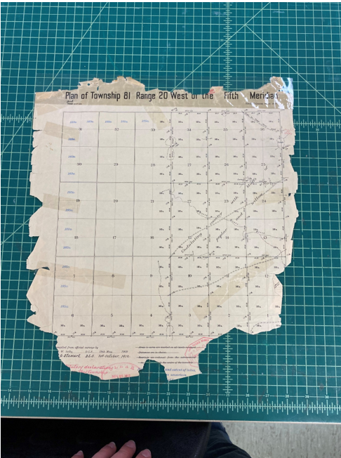
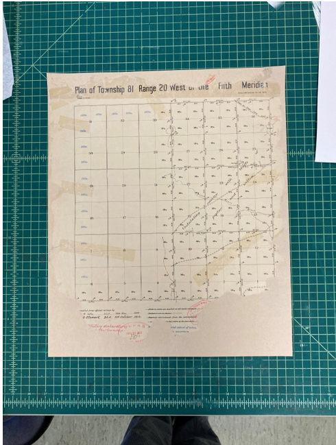
What makes the township maps at the PAA so useful to researchers are the annotations, which typically appear on one map in each township set.

In addition to general descriptions of the land itself, the annotations include references to individuals and organizations connected to specific quarter-sections of land. While references to railway companies, school lands and the Hudson’s Bay Company are standard across most maps, handwritten annotations to file numbers and the names of individual homesteaders provide insight into the earliest years of settlement in the region and are valuable to genealogical researchers.
First created and maintained by the survey offices in Ottawa, the township maps and associated records were later transferred to the Government of Alberta at some point after the Natural Resources Transfer Agreement of 1930. The records were then used in the offices of various government agencies responsible for land surveys and acquisitions until digital versions made the paper versions obsolete and no longer required for day-to-day operations. Recognizing their ongoing value as evidence of early settlement activities, the PAA acquired the records through the government records scheduling process and began to make them available to researchers.
Although the PAA provided the best possible containers and environmental conditions for the continuing storage of the records, over a hundred years of handling and use have taken their toll. While some maps remain in good condition and retain their vibrant colours, others show significant wear and deterioration, with some maps damaged to the point of losing information.
Faced with the continuing deterioration of such a valuable research resource, the PAA decided to remove the original township maps from circulation in 2024, meaning that they would no longer be pulled from the vaults for consultation by researchers.
However, recognizing their importance to a variety of researchers, the PAA initiated a variety of projects to improve access to the records, particularly in an online setting. Archival technicians undertook rigorous quality control to confirm that the list of maps was correct, and every map was scanned to a quality sufficient for use by researchers. Archivists revised the description of the records to capture the context of their creation more accurately. To augment Indigenous content on the website, archivists also added geographic access points to identify First Nations reserves as well as Métis settlements represented on the maps.
Ultimately, the PAA uploaded over 18,000 item level descriptions into its new Access to Memory (AtoM) database and attached them to the township plans, register and settlement maps series description. This description not only captures the township maps but also uses the “related records” field in the notes section of the description to draw together other records connected to the survey process, such as the correspondence and field notebooks of the land surveyors.
An additional benefit of integrating the township maps into the larger AtoM database was the addition in the file list of a standardized reference to the legal land description. For example, typing in 50-23-W4 (representing Township 50, Range 23, West of the 4th Meridian) without quotation marks gives 160 search results that include the township maps as well as a variety of other research sources, only some of which are connected to that location.

The broad nature of the search may produce less relevant results, and this may appear overwhelming at first to someone just seeking the township maps. However, there are strategies to narrow the search. Using the same search but with quotation marks (“50-23-W4”) produces a different result but now only 125 entries.

With both search methods, researchers have the option to click on the “township plans, register and settlement maps” link on the left-hand side of the page (under “narrow search results by” and “part of”). This link takes the researcher to a single search result that, when clicked on, takes the user to the digitized maps for that township. Once there, a researcher can examine each of the maps, make them larger, print them or save their own reference copies.

As a testament to the process of settlement in Western Canada, the township maps provide unparalleled evidence not only of the broader impacts of settlement but also the individual experience of homesteaders. While the original maps in the vaults of the PAA are now protected from further handling and damage, their digital facsimiles in the AtoM database provide researchers around the world with colourful cartographic images as well as new perspectives on the history of land surveying and settlement in Alberta.
