In addition to two articles published earlier this year, this blog announces the release of four new articles to complete the volume:
Microblades in northwest North America
Skilled flintknapper Eugene Gryba discusses a specific stone tool technology called microblades in northwest North America. He draws on decades of first-hand experience creating stone tools to argue for a free-hand pressure technique to explain archaeological occurrences of microblades across the continent.
Napi effigies
Trevor Peck presents an updated synthesis of unusual and intriguing archaeological features called petroforms (boulder outlines), in this case, Napi effigies on the Plains. These large arrangements of boulders depict an important Siksikaitsitapi (Blackfoot) entity who figures prominently in stories and belief systems. The paper discusses their style and distribution and argues for a subdivision of different groups of Napi effigies that may be linked to different phases of Siksikaitsitapi history.
Porcellanite
A team of archaeologists is studying the raw materials used in Alberta to make stone tools over the past 12,000 years. The fifth paper in the current volume discusses a material called porcellanite that was fused over millions of years through natural coal combustion. Indigenous people used porcellanite from Montana, North Dakota, and from local outcrops in Alberta to make stone tools. The paper presents photographs and several laboratory results to help archaeologists accurately identify porcellanite.
Surface collection of artifacts
The final paper in the volume presents an interesting surface collection of artifacts from northern Alberta. The collection from the Fort Vermilion area includes stone projectile points, scrapers, knives, cores, and flakes made out of a variety of raw materials. Heinz Pyszczyk and colleagues from the Royal Alberta Museum and the University of Lethbridge argue that tool styles and affinities to the south suggest that the collection represents 9000 years of human occupation in the region.
Previous volumes can be downloaded for free here. Thank you to all the authors. If you are an archaeologist interested in contributing to the 2021 issue, dedicated to heritage in Canada’s boreal forest, please contact the Archaeological Survey of Alberta.
Editor’s note: On June 10, 2021, the Provincial Archives of Alberta reopened to the public. Once again, the larger team will be safely assisting researchers with reference queries and research visits. If you have found yourself with a question about Alberta’s heritage or your own family history, please visit the Reading Room or contact us. PAA archivists are ready to assist.
Written by: Natalia Pietrzykowski, Reference Archivist
Social distancing, PPE, flattening the curve. These phrases became commonplace as the world adapted to the COVID-19 pandemic, which was declared in March 2020. Another word that will resonate with most professions during this last year is “pivot.” In many cases, public safety needs resulted in “pivoting” business operations to contactless or even remote services. Due to COVID-19, most staff at the Provincial Archives of Alberta (PAA) spent part of 2020-21 working from home. This presented us with a challenge: how do we take archival work home? The search for a solution was also an opportunity to develop new ways of providing access to information and focusing on making improvements to future service. In the last year, PAA staff continued to work on projects that support the mission of preserving and making available records of enduring value. Here, we will share a few highlights of heritage work during a pandemic year, pivots and all.
Virtual Reference
On March 17, 2020, the PAA closed to the public as Albertans were prohibited from attending public recreational facilities. The PAA Reading Room remained closed for 14 weeks, during which time reference archivists answered more than 500 public queries by email. The public response to “virtual” service was overwhelmingly positive.
On June 23, the PAA Reading reopened to in-person researchers, by appointment and with a reduced capacity. This new model of reference service required a much higher degree of up-front coordination than our previous walk-in availability. Only staff were allowed to handle the finding aids (primarily printed binders and card catalogues) that are available in the reading room. Relevant records had to be identified and pulled prior to appointments, after which they entered a 72-hour quarantine period. Additionally, archivists continued to provide virtual reference services for those unable to visit, sharing electronic finding aids and research copies of records to help answer questions.
The average time spent addressing public and government queries was adjusted from approximately 15 minutes per request to 1.5 hours per request, whether for an appointment or to answer a complex research question. We needed many hands on deck to provide additional research services; 10 archivists, two managers and two Young Canada Works interns all contributed to rotating reference coverage. This work was also supported by a retrieval aide, archival technicians and PAA administrative staff. Three-hundred and seventy-two researchers visited the PAA between the June and December 2020. On top of that, the team answered almost 1,350 reference emails and phone calls. In late 2020, the reading room was required to close again.
In total, from April 2020 to March 2021, PAA archivists responded to 3,936 public reference inquiries. Source: Provincial Archives of Alberta
Editor’s note: For our next instalment recognizing National Historic Places Days, we look at the Register of Historic Places, what information it contains and how to use the database to search for historic resources. It’s recommended that while you read this article, you follow along on the Heritage Resources Management Information System.This database works best using Internet Explorer.
Written by: Dorothy Field, Heritage Survey Program Coordinator
Alberta’s provincial and municipal governments have recognized and protected over 800 historic resources. Did you know that information about all of these significant sites is available to the public? Read on to find out all about where this information is located, and how you can learn more about Alberta’s historic places.
What is the Alberta Register of Historic Places?
The Alberta Register of Historic Places is a searchable database of legally protected historic places in Alberta, including sites designated by the province and by municipalities.
Where can I access the Alberta Register of Historic Places?
The register is available to the public on the HeRMIS (Heritage Resources Management Information System) website. Here it is possible to find information about the location, significance and level of designation for designated historic resources. In addition to this data, the website also includes photographs and an interactive map.
What sorts of things are listed on the Alberta Register of Historic Places?
A wide variety of historic resources have been designated in Alberta, reflecting the range of resources that are significant to Albertans. In fact, if it’s not a small moveable object, human remains, or no longer in its historic context, just about anything that’s provincially or municipally significant could be designated and listed on the register. There are things on the register you might expect, like the Legislature Building in Edmonton and the Rowley Grain Elevator Row, near Big Valley. There are also unexpected things, like significant geological features such as the Whitecourt / Woodlands Meteorite Impact Crater, or important biological sites like the Wood’s Douglas Fir Tree Sanctuary in Calgary. There are all kinds of other designated historic resources, including industrial sites and machinery, palaeontological sites, engineering structures, homes, commercial buildings, churches and more – all of them illustrating some significant aspect of Alberta’s history.
What can I do with the Alberta Register of Historic Places?
You can search the register to learn about a wide variety of topics relating to Alberta’s history – from archaeology to architecture to astronomy, from the prairies to the Rockies and the 49th to the 60th parallel. You can use the Map Search function to plan a tour to view historic resources within a community or along a route between communities.
Written by: Ron Kelland, Geographical Names Program Coordinator
In July 2021, Canada is marking Historic Places Day, or Days as the case may be. First declared in 2017, Historic Places Day is an initiative of The National Trust of Canada as an opportunity to highlight historic places across Canada, to tell their stories and encourage Canadians to learn about, experience and interact with them to foster a better appreciation of the important role these places have in the lives of Canadians and how they impact the quality of life in our communities.
Historic places take many forms, from old and grand public buildings and monuments to small and homey bungalows and farmhouses, to workers cottages, archaeological and paleontological sites, museums and cenotaphs. With summer now here and people looking for opportunities to enjoy the outdoors, we thought it opportune this year to feature some of Alberta’s parks and outdoor public spaces that have been designated as historic resources. So, grab your walking shoes or hiking boots, bring your camera and lots of water, and let’s explore some these historic parks across the province.
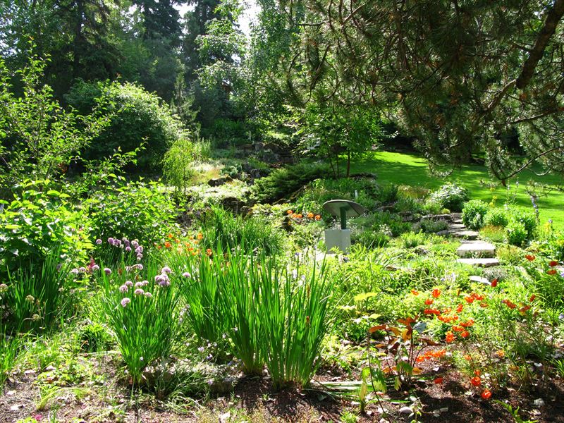
Located adjacent to Calgary’s Union Cemetery, the Reader Rock Garden is an early twentieth-century naturalistic garden composed of rocks, primarily local sandstone; trees; water features; and paths. The garden was designed by William Roland Reader, superintendent of parks and cemeteries for the City of Calgary from 1913 to 1942. Reader was heavily influenced by the City Beautiful movement, which advocated for the inclusion of well-designed green spaces in urban environments. Under Reader’s leadership, Calgary saw the establishment of many parks, playgrounds, golf courses and tennis courts around the city and the planting of trees along city streets. Reader created the Rock Garden as a semi-private park, it was located around the superintendent’s cottage, now a reconstructed elements in the park, and as a living, laboratory where he experimented with thousands of varieties of plants. Reader’s botanical experiments and meticulous observations influenced horticulture across North America through his writings and the distribution of seeds.
Editor’s note: Our first article recognizing #HistoricPlacesDays takes us to southern Alberta. The banner image above, featuring low-lying rear lots with gardens in Lethbridge’s Chinatown in 1956, looking west, is courtesy of the Galt Museum and Archives.
Written by: Fraser Shaw, Heritage Conservation Advisor
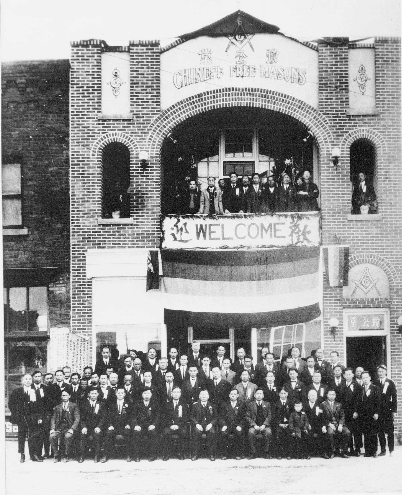
Since its construction in 1924, the Chinese Free Masons Building has been an anchor in the physical and social fabric of downtown Lethbridge and on of Alberta’s most intact historic “Chinatowns”. A large crack zigzags across the west wall of the Provincial Historic Resource and propagates east down the block, telegraphing through the walls of its historic neighbours and terminating at the old No. 1 Fire Hall. The crack recently presented repair challenges and is the legacy of a historic landscape and a transformed physical and cultural geography.
1990s photograph from the northwest with the west wall crack and previous repairs clearly visible toward the back (right) half of the building. Source: Historic Resources Management Branch.
Some 12,000 years ago, as the Laurentide ice sheet retreated toward Hudson Bay, torrents of meltwater carved deep channels across southern Alberta, including today’s Oldman River valley. Long tributary coulees reached like fingers from the valley’s east side, a pattern evident today along the escarpment behind the Galt Museum. One of these coulees extended east between what is now 2nd and 3rd Avenue South and appears in early plans and photographs of Lethbridge. Uneven and difficult to build on, the block attracted Chinese immigrants and entrepreneurs who established new businesses on lots that were strategically close to the fledgling town centre but slightly apart from it, a development pattern reinforced by discriminatory policies of the day that relegated Chinese-owned businesses to marginal land away from the commercial core.
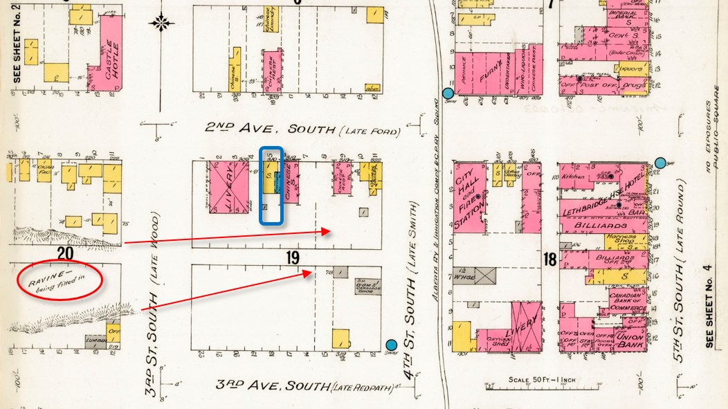
A fire insurance map of 1910 predates the construction of the Chinese Free Masons Building on Block 19 Lot 5 (blue outline) but notes infilling of the ravine or coulee (circle at lower left). Arrows indicate the original extent of the coulee eastward through Block 19. Source: Library and Archives Canada, with added annotations.
Development has infilled the coulee such that the historic landscape today survives only in the sunken rear lots of the Bow On Tong Company Building and Wing Wah Chong Company Building, both of which are Municipal and Provincial Historic Resources. These low-lying back yards were historically put to good use, providing direct access to basement apartments for newly arrived immigrants from China and serving as vegetable gardens (see banner image at top of page). Though hidden, the buried coulee survives as relatively weakly consolidated infill soil under the back portions of the block’s historic buildings. These areas move and crack as soil compacts, takes up water from the poorly drained rear lots, or moves seasonally where shallow rear foundations are susceptible to frost heave. The rear lot at the Chinese Free Masons Building has been infilled but unstable soil conditions persist and cause structural movement and recurrence of the west wall crack despite repeated patching.
1924 photograph, possibly showing the Masonic hall’s grand opening. Source: Galt Museum and Archives photograph 19800128000.
Foundation underpinning on deep piles into undisturbed soil would stop the structural movement and cracking but is very costly. A local architect assessed no immediate threat to the building and recommended a practical and cost-effective crack repair alternative. This consisted of saw cutting a new flexible control joint into the outer wythe or layer of brick beside the old crack, to accommodate ongoing structural movement while maintaining integrity as a weather seal. The existing crack was too irregular for proper installation of a reliable sealed joint. As a precaution, the established crack was also repaired with flexible sealant, into which masonry sand was pressed to resemble a traditional mortar joint and disguise the repair as much as possible.
Conservation work normally favours traditional materials but a deep mortar repair risked “locking” the wall in place and causing cracks to appear elsewhere. Correctly formulated lime mortars can absorb some movement and even “self heal” as free lime recrystallizes within emerging hairline cracks — but structural movement at the Free Masons Building demanded a more elastic joint.
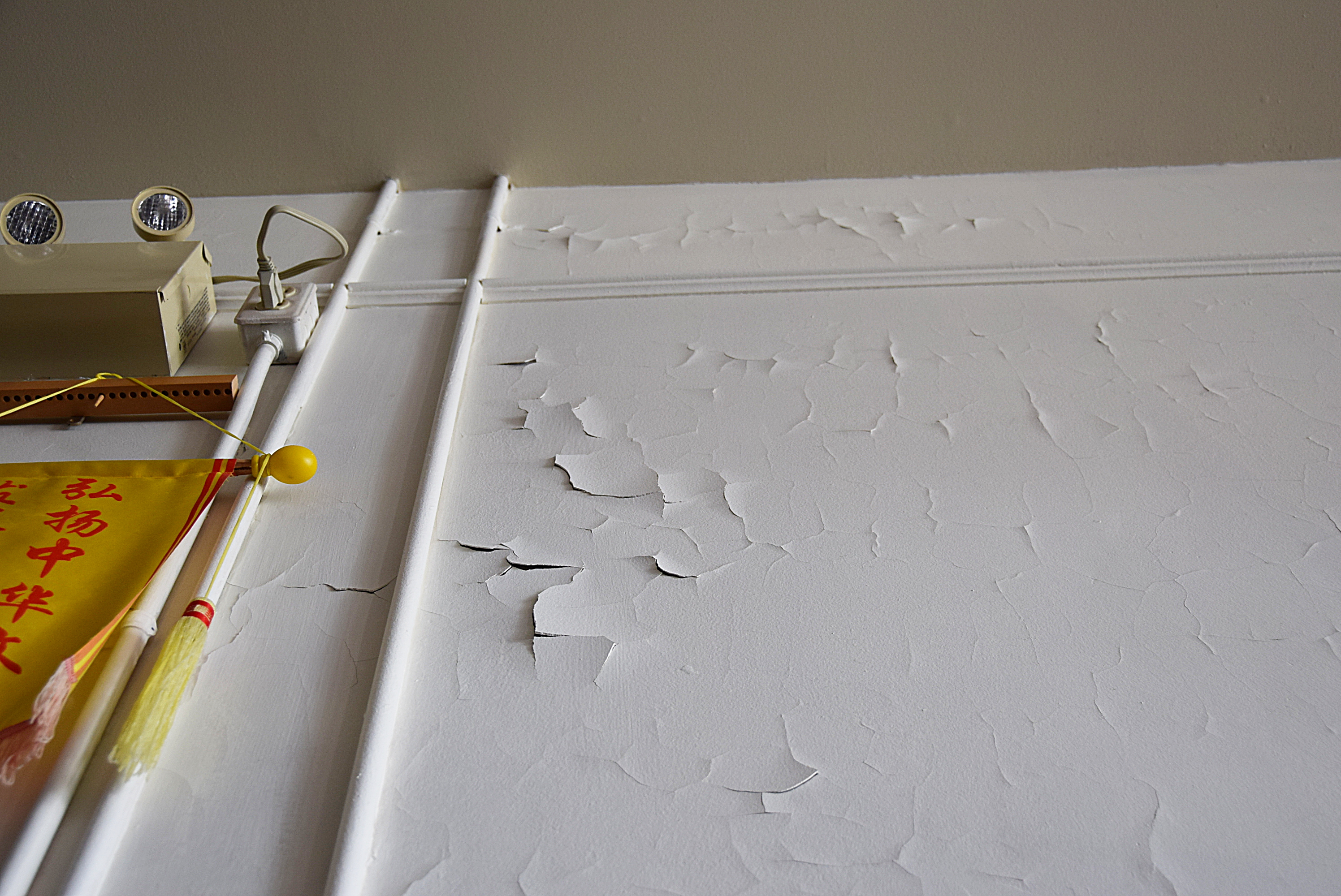
Paint failure on second floor interior west wall, April 2019. Source: Historic Resources Management Branch.
The second floor offers a large open space that has served as a Masonic hall for almost a century. The interior walls are original plaster applied to the interior face of the brick masonry exterior walls. Coated with many layers of paint, the walls deteriorated rapidly after the interior was repainted to hide smoke damage after a fire in 2009. Driving rain through the west wall crack was initially suspected as a moisture source but the extensive paint failure was actually in another location. Further assessment determined that the problem was excess moisture within the wall combined with the wall’s inability to dry through impermeable layers of paint.
The west wall is thus a highly porous brick that readily absorbs moisture. Like many old brick buildings, the Chinese Free Masons Building uses a high-quality, durable brick on the front facade with less expensive bricks on the side walls that were often intended to be protected by adjacent buildings. Mortar joints also play a role: lime mortar both binds the masonry and actively wicks moisture in the wall to the surface, where it then evaporates. However, as mortar weathers, leaching of the lime binder reduces this wicking action and eroded joints provide more surface area for water absorption, effectively turning a wall into a sponge. On the wall’s inner face, permeability declines with each layer of paint and as old alkyd paint ages. The most recent repainting was the last straw: acrylic latex paint is vapour-permeable but drying of the wall fabric relies on liquid (if microscopic) capillary moisture transfer. The result is that moisture absorbed through the exterior brick trapped within the wall literally pushes the paint off the plaster.
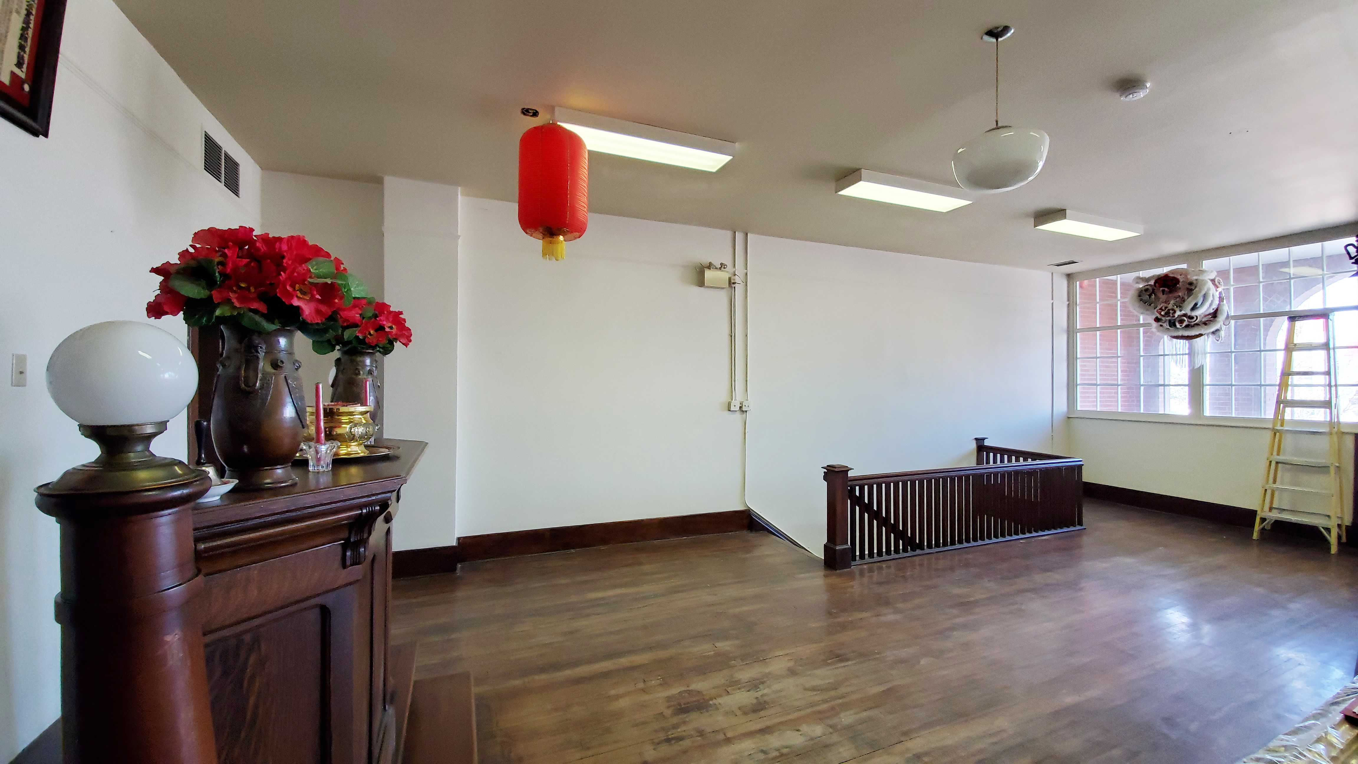
Second floor (Masonic hall) with far wall after plaster repairs and application of clay paint, March 2021. Source: Historic Resources Management Branch.
To correct the problem, peeling interior paint was stripped by hand and moisture-damaged plaster was patched with a compatible gypsum plaster free of latex or polymer additives that might otherwise impede prevent drying. A special, highly permeable clay-based paint was applied to the wall and colour-matched to the historic interior. Combined with renewing or “repointing” the exterior masonry with a compatible lime mortar, these measures avoid sealing the wall and instead restore the historic fabric’s intrinsic ability to absorb, buffer and release moisture by drying to the interior and exterior. The repaired west wall with its new control joint and evidence of the old crack are a testament to ancient landforms, local history and Lethbridge’s evolving urban landscape.
View from northwest in June 2021 with new control joint on west wall and muted expression of historic crack. Source: Historic Resources Management Branch.
Sources:
C.B. Beaty and G.S. Young, The Landscapes of Southern Alberta: A Regional Geomorphology (Lethbridge: University of Lethbridge, 1975), 66-77.
For a discussion of the early development of Lethbridge’s Chinatown, see David Chuenyan Lai, Chinatowns: Towns Within Cities in Canada (Vancouver: University of British Columbia Press, 1988), 90-91.