As Albertans begin to safely hunker down for the holiday season, you might think about picking up a project left at the side of your desk. Or maybe you’ll start something new altogether. If you’re someone thinking of learning more about your family history; if you’re a non-profit group wanting to mark a moment in your local history; or a person who wants to preserve the lived experiences of an older generation, these new resources will certainly help.
Developed by staff in the Alberta government’s Heritage Division, the Heritage Note Series so far consists of resource guides covering three topics: historical research, heritage markers and oral history. In these guides, you’ll learn skills like how to properly conduct an interview, how to write text for historical signage and how to manage research notes and materials.
Written by: Colleen Haukaas, Archaeological Survey
Join the Historic Resources Management Branch as we celebrate GIS Day 2020. GIS, or geographic information science, is a scientific framework for gathering, analyzing and visualizing geographic data to help us make better decisions. At the Historic Resources Management Branch, we have been using GIS since the early 2000s to better understand our historic resources.
GIS at the Historic Resources Management Branch
Alberta is home to tens of thousands of historic resources, and our Branch needs to be able to analyze where those resources are, if there are concerns about the resources, and the best way to address those concerns. At the Branch, we maintain several geospatial databases for our program areas: archaeology, palaeontology, Aboriginal heritage and historic structures. Each database is modified throughout the year as new information is made available (e.g. when new sites are recorded).
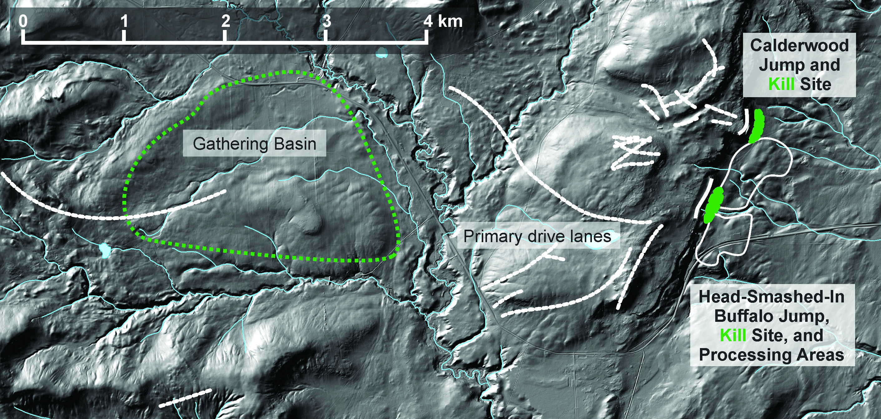
We investigate archaeological sites individually in research, but we also need to understand how sites relate to each other and to broader cultural and natural landscapes. GIS helps archaeologists understand these broader questions. The images below show how we use GIS to understand the broader context of archaeological sites Head-Smashed-In Buffalo Jump and Calderwood Buffalo Jump, courtesy of Todd Kristensen. Archaeologists have investigated the sites through methods such as survey, excavation and artifact analysis. Through GIS, we can then begin to understand the context of the sites within their local topography and see the gathering area, drive lanes and kill areas. We can also see how the sites fit into the broader tradition of bison jumps, pounds, and kill sites on the Great Plains.
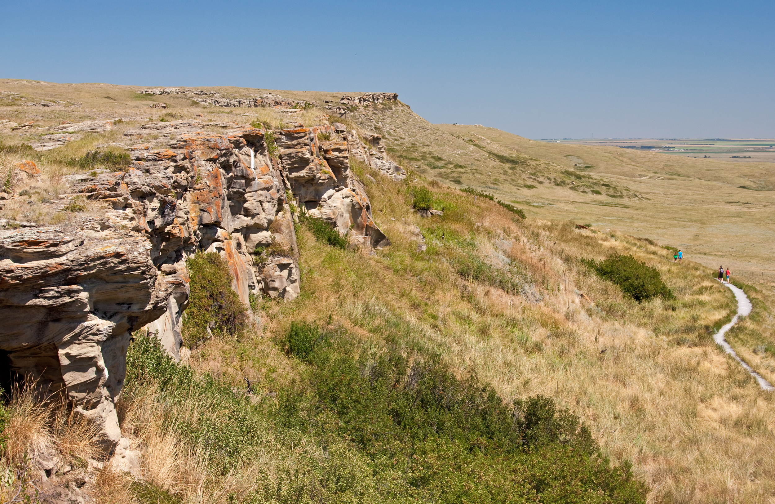
The sandstone cliffs at Head-Smashed-In. Archaeologists have excavated through over 8 m of sediment and bone at the base of the cliff to reach the oldest layers of pre-contact hunting at Head-Smashed-In. Image courtesy of Alberta Culture and Tourism.
This image cultural landscape of Head-Smashed-In Buffalo Jump in the physical topography. Buffalo runners drew buffalo out of the gathering basin into drive lanes- valleys with lanes built up with piles of stones and brush. Once the bison were inside the lanes, people behind blinds drove the bison over cliffs that gave the illusion of continuing prairies. Courtesy of Todd Kristensen.
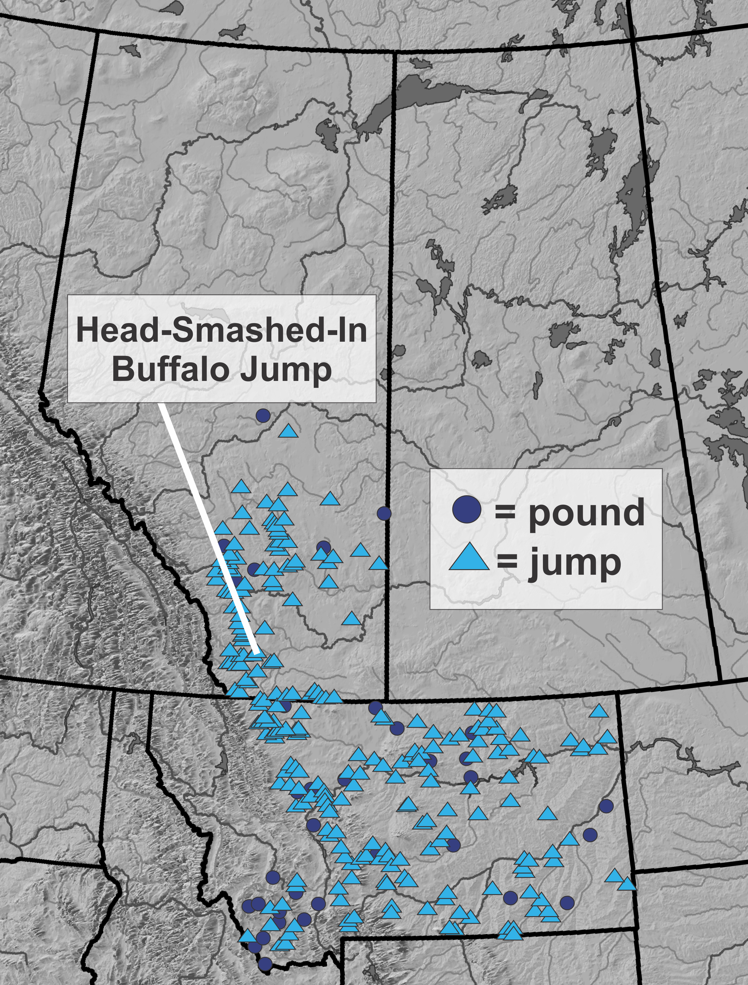
Evidence of large-scale buffalo hunting is evident across the northern plains. Head-Smashed-In is one of many sites that people used for communal hunting. Courtesy of Todd Kristensen.
Editor’s Note: November 15- 21 is Métis Week: an opportunity to recognize the culture, history and contributions of Métis people to Alberta and across the country. The following post is written by Matt Hiltermann on behalf of Métis Nation of Alberta Region 3. Through extensive research of census records and archival material, Matt tells the story of the many Métis families who lived at the confluence of the Bow and Elbow rivers, and who contributed to the social fabric of Rouleauville—one of Calgary’s oldest neighbourhoods.
Communities do not spring from the soil fully formed; rather, they tend to coalesce around existing population centres, important trade routes, and/or vital resources, among other things. As a fording place for the buffalo herds, the area that would become Calgary and its environs was an important gathering place for the Niitsitapi (Blackfoot) and their Tsuut’ina and Stoney Nakoda allies since time immemorial. [1] Due to its status as a gathering place rich in resources, by the mid-19th century, Métis freeman bands with kin ties to the Tsuut’ina or Niitsitapi began to visit these peoples along the Bow. [2] These Métis freemen acted as middlemen in the ever-important pemmican trade that fueled the Hudson Bay Company’s (HBC) northern trading posts, brigades and the fur trade more broadly.[3]
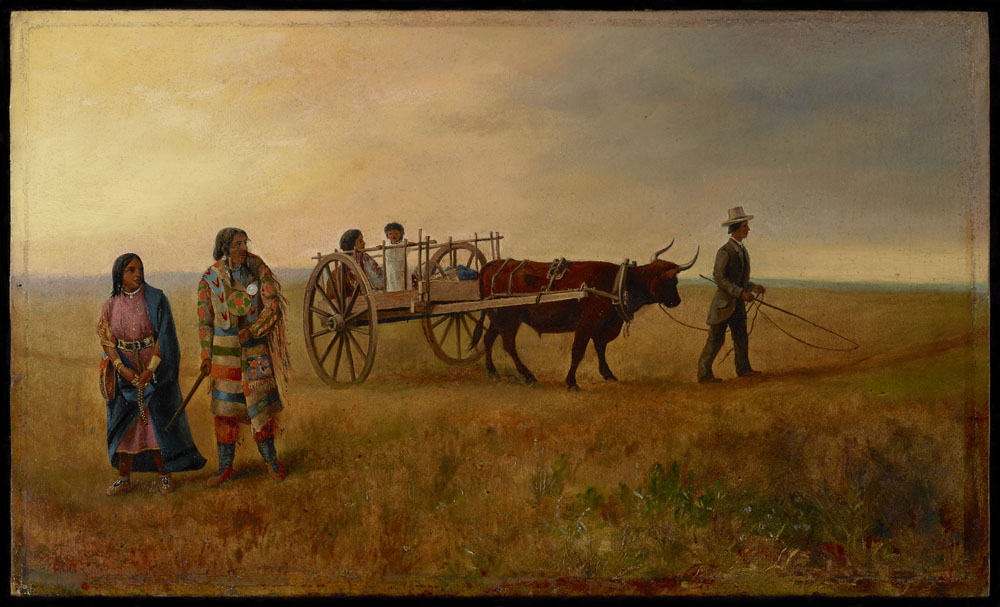
“A Red River Cart at Calgary, N.W.T.” Painting by Edward Roper, ca 1887 – 1909. Source: Library and Archives Canada.
Written by: Ron Kelland, MA, MLIS, Geographical Names Program Coordinator
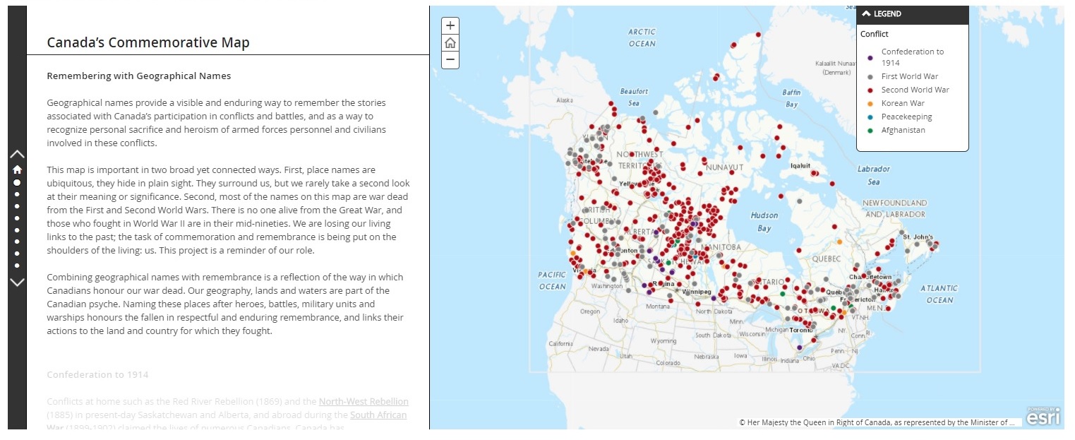
November 11 is Remembrance Day. The day that Canadians are called to set aside in honour and recognition of its military service personnel that paid the ultimate price in their defence of our nation and its values. Canadians have fought in numerous wars and as the memories of some of those wars are fading as decades pass and the last surviving veterans of those wars pass away, it becomes even more important to remember those that fought and died and those that fought and lived to preserve the memories of their fallen comrades. Canada’s Commemorative Map is one of the ways to keep the memory of those sacrifices alive.
In 2018, the Geographical Names Board of Canada launched Canada’s Commemorative Map, an interactive, digital map that highlights places and features in Canada that were named to honour and commemorate Canada’s war heroes and casualties. Source: Geographical Names Board of Canada.
Commemoration of Canada’s war casualties have taken many forms. Following the end of the First World War, there was a national effort to erect plaques, cenotaphs and other memorials in cities, towns and villages across the country. These memorials of the First World War are often the sites of our Remembrance Day services and ceremonies to this day. Some communities built needed infrastructure and facilities, such as arenas, performing arts centres, libraries and community halls dedicated to memory of those that gave their lives in military services.
Written by: Fraser Shaw, Heritage Conservation Advisor
Recently, I visited the Maccoy Homestead in High River after seven long years of flood repairs and conservation. Nestled in Sheppard Family Park near the south edge of High River, this was the farm and home of well-known local resident Ruth Maccoy for over 70 years. Upon her passing in 1995 and at her bequest, the farm became Sheppard Family Park with the homestead as its nucleus.
The home is a charming 1883 whitewashed log building, the earliest structure on the site, with a frame addition and porch built by her parents in the 1920s and surrounded by a garden and picket fence lovingly tended by Ruth Maccoy over the years. Behind the house are a garden shed, a small guesthouse, and a root cellar set into an embankment, while the garage is located nearby. A path leads west through the trees to a footbridge over the Little Bow River, usually a shallow creek, to the historic water source in a natural spring.
One of High River’s first municipal designations, the Sheppard/Maccoy House was designated as a Municipal Historic Resource in 2009 by the Town of High River for its association with Ruth Maccoy and early settlement in the area. An exceptional example of an early farm, the site also exemplifies the contribution of women’s labour to homesteading and agriculture in rural Alberta and was designated a Provincial Historic Resource in 2015. The site is a good example of how complementary municipal and provincial heritage values tell a richer story and was the subject of a RETROactive post earlier this summer.