

Written by: Ron Kelland, MA, MLIS, Geographical Names Program Coordinator
November 11 is Remembrance Day. The day that Canadians are called to set aside in honour and recognition of its military service personnel that paid the ultimate price in their defence of our nation and its values. Canadians have fought in numerous wars and as the memories of some of those wars are fading as decades pass and the last surviving veterans of those wars pass away, it becomes even more important to remember those that fought and died and those that fought and lived to preserve the memories of their fallen comrades. Canada’s Commemorative Map is one of the ways to keep the memory of those sacrifices alive.
Commemoration of Canada’s war casualties have taken many forms. Following the end of the First World War, there was a national effort to erect plaques, cenotaphs and other memorials in cities, towns and villages across the country. These memorials of the First World War are often the sites of our Remembrance Day services and ceremonies to this day. Some communities built needed infrastructure and facilities, such as arenas, performing arts centres, libraries and community halls dedicated to memory of those that gave their lives in military services.

Another form of memorialization of Canada’s wartime heroes and casualties was through the adoption of commemorative names for places and geographical features. Where the erection of monuments and the dedication of buildings were typically bottom-up, community-driven initiatives, the naming of geographical features for commemorative purposes was a distinctly top-down, government initiative and the type of commemorative names reflected that perspective . Following the First World War, commemorative place names in Alberta focused on honouring the political leaders involved in the war effort and commemorating major battles, notably the Battle of Jutland and Vimy Ridge. These naming initiatives were more about commemorating the First World War as a national event and to solidify Canada’s position as an important player in the Imperial and international war effort; there was very little in the way of commemorating individual military personnel.
In Alberta, the rationale for commemorative place names changed following the Second World War. By the late-1940s, the Government of Alberta had established the Geographic Board of Alberta, which offered recommendations to the Geographic Board of Canada on place naming matters in the province. So, while the naming of geographical features remained a federal government responsibility, and would continue to do so until the 1970s, the provincial government was able to exert more influence on the naming process and the type of names adopted.

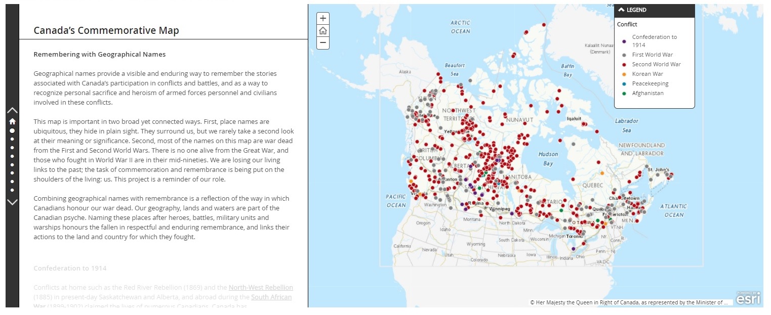
Canada’s Commemorative Map aims to make more Canadians aware of place names that commemorate our military personnel. The map was create through the work and cooperation of the federal government, through the Geographical Names Board of Canada and the geographical names programs of Canada’s provinces and territories. All provinces and territories selected commemorative names for features in their territory and submitted them for inclusion on the map. The map is updated periodically with the inclusion of other names that fit certain military anniversaries and themes, as well as through the addition of newly adopted names. The map generally focuses on geographical features named for individuals or for events in which Canada or Canadians were directly involved in. Place names adopted for more political or diplomatic purposes, such as the Battle of Jutland, and mountain names in Kananaskis Country are not included. Not all of Alberta’s commemorative names are currently included on the map, however additional names are added each year.
As of November 11, 2020, the Alberta Geographical Names Database contains approximately 400 official place names that relate to about 1,161 military personnel, battles, ships or other events. A number of these commemorate non-Canadians or events in which Canada or Canadians were either not involved in or involved tangentially. Exact numbers are not available as some names have not yet been definitively researcher, assessed and tagged.
Some Alberta examples of these names are:
Northwest Rebellion
Haight Island
This island in the Athabasca River 55 km NNW of Fort McMurray is named for steamboat captain E. B. Haight. A Hudson’s Bay Company man from 1882 to 1931, Haight piloted steamboats on the Nile in 1884 during the Khartoum Expedition Haight and served during the Northwest Rebellion. Haight spent most of his career piloting Hudson’s Bay Company steamboats on the Athabasca River.

Pruden Lake
This lake 16 kilometres south of Lac La Biche is named for Patrick Pruden, a Métis trader who operated a trading post near this lake. Pruden was in charge of the Hudson’s Bay Company post at Lac la Biche when it was raided during the Northwest Rebellion. He also helped to organize the defence of the Lac la Biche mission in preparation for additional anticipated raids, which did not occur.
First World War
George Peak
This peak on Mount May is named for Lieutenant George Geoffrey May of the 75th Battalion (Mississauga), Canadian Expeditionary Force, who was killed in action on April 9, 1917 during the Battle of Vimy Ridge. A neighbouring peak, Francis Peak is named for his brother, who was killed in action on June 2, 1916. Like many of the commemorative mountain names in Alberta, Mount May, George Peak and Francis Peak were named by the Alberta-British Columbia Inter-provincial Boundary Survey.
Harwood Lake
This lake, located 85 kilometres southeast of Fort Chipewyan is named for Colonel Reginald De Lotbinière-Harwood of Quebec. Trained as a doctor, Lotbinière-Harwood established a practice in Pincher Creek and Edmonton. He was commander of the 51st (Edmonton) Battalion when it went overseas in 1916. However, he soon transferred to the Canadian Army medical Corps. Following the war, he commanded a military hospital in Edmonton.
Mons Peak
This peak on the Alberta/British Columbia boundary is named for the Belgian town of Mons. The town was lost in 1914 and remained in German hands until it was recaptured by Canadian troops shortly before the armistice in 1918.

Second World War
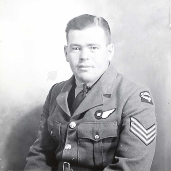
Joyce River
Formerly known as Smallpox Creek, this stream, which flows into the North Ram River approximately 72 kilometres west of Rocky Mountain House, was renamed in 1950 for Squadron Leader R.G. Joyce. Joyce, who flew with the 435 RCAF Squadron. On February 13, 1946, Joyce was piloting a Dakota 3 aircraft, transporting four crew and 20 mostly military passengers from Buckeburg, Germany to Croydon, England. When attempting to land in heavy fog, the aircraft hit a hill nine kilometres south of the Croydon airfield. Two of the crew, including Squadron Leader Joyce and six of the passengers were killed in the crash.
Mount Worthington
This mountain on the Alberta/British Columbia Boundary west of Turner Valley is named for Lieutenant-Colonel Don Worthington, Commander of the 7th Battalion, British Columbia Regiment, Royal Canadian Armoured Corps. Lt.-Col. Worthington was killed in France during Operation Totalize on August 9, 1944 after becoming trapped behind German lines.
Wilson Creek
This creek, which flows into the Medicine River, 20 kilometres west of Rimbey, is named for Pilot Officer Raymond Wilson of Gadsby. Wilson was an Royal Canadian Air Force Officer flying with 13 Squadron of the Royal Air Force. Wilson was a gunner and wireless operator. He was killed when his Baltimore Light Bomber crashed during operation in Italy on August 23, 1944.
Korean Conflict
Wood Lake
This lake, located just east of Grande Prairie, is named for Warrant Officer Class I James Deans Wood of Ranfurly, Alberta. Wood was awarded the Distinguished Conduct Medal for his bravery during the Italian campaign of the Second World War when his company, A Company of the Princess Patricia’s Canadian Light Infantry, was attempting to gain a bridgehead over the River Savio. He continued to serve into the Korean Conflict, where, on January 18, 1951, he was killed in Miryang, South Korea by a landmine during a training demonstration.
Canada’s Commemorative Map is part of a series of interactive maps being developed by the Geographical Names Board of Canada and its members. The goal of these maps is to build more awareness amongst Canadians about place names and their important cultural role. The other map currently available is Stories from the Land: Indigenous Place Names in Canada. Additional maps are under development.
Sources:
Canada. Environment and Natural Resources. Geographical Names Board of Canada. Canada’s Commemorative Map. (Ottawa, ON), 2018 [updated 2019].. https://maps.canada.ca/journal/content-en.html?appid=3f3247733f244707bb77cd94a3c5ff2f&appidalt=255b1d3aaba446e5b2406977db503f22&locale=en
Alberta. Culture, Multiculturalism and Status of Women. Alberta Geographical Names Database. [non-published].
