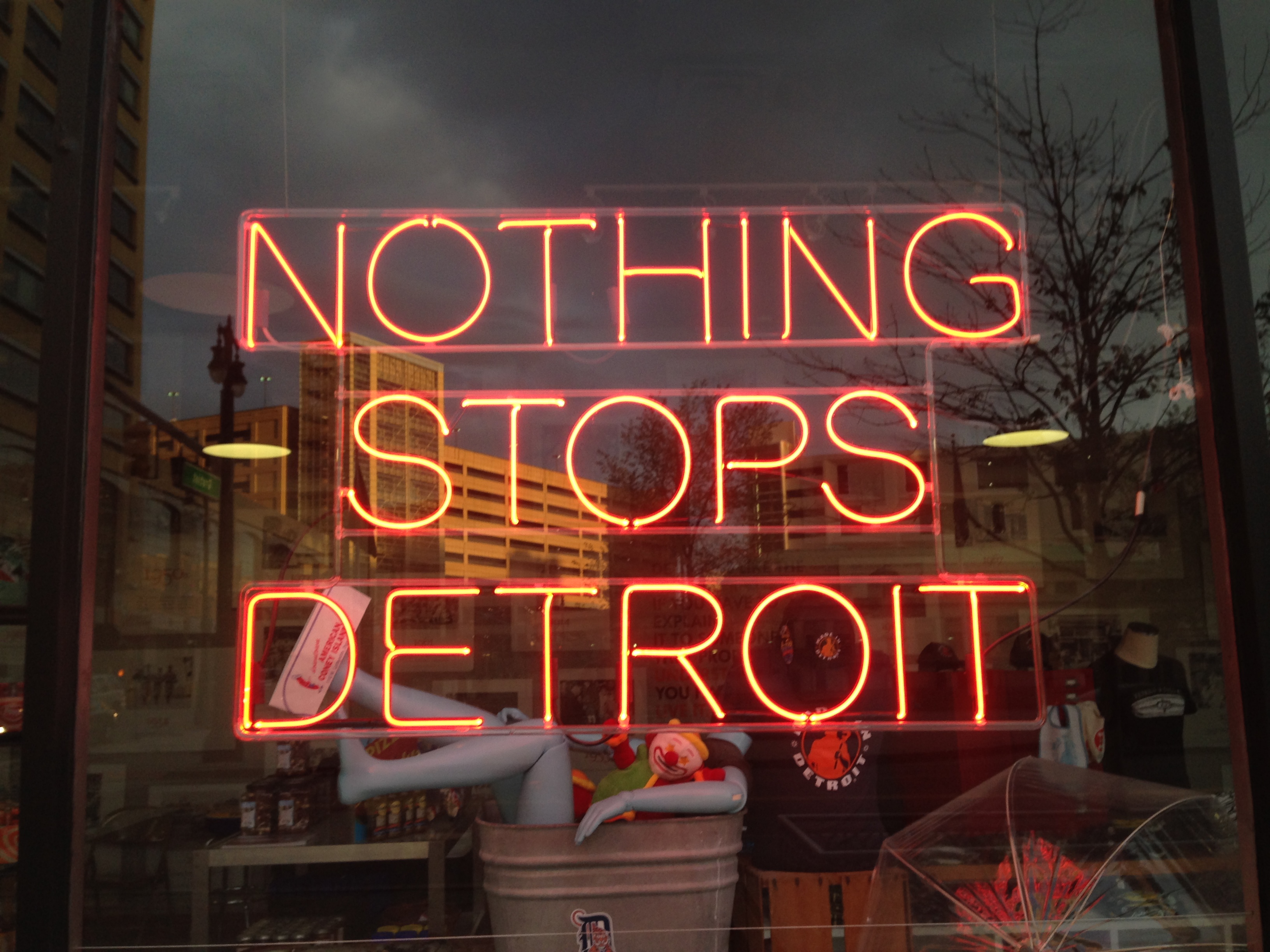
You have no doubt heard of the trials and tribulations of the City of Detroit: the near death of the auto industry, massive population loss, infrastructure woes and high crime rates. The negative connotations have led to a public image of a city abandoned and in upheaval whereas the best-case-scenario associations portray it as a playground of urban decay and rock-bottom housing prices. When I learned that the National Main Street Conference was being held in Detroit this year, I was pleased that I would be able to see it for myself, albeit in the cocoon of a programmed conference setting.
Having now been there I can make a few comments. First, it is a stunning city. There are architectural marvels (both in use and abandoned), striking parks and trail networks and an eclectic mix of things to do. Second, the city is hard at work. Travelling in and around the downtown core, there is evidence of a community working to rebuild and repair. Third, the city seems to be acutely aware of the volunteerism and resources required to improve its image. Bike patrols and on-foot clean-up crews strive to ensure the downtown core is safe and clean. Residents are cheerful and exceptionally welcoming.
This said, did I really see Detroit? Visiting as part of a conference I no doubt had a curated experience of the city and limited time for exploration. It is important to remember that there are layers that we do not understand: a history of labour and race disputes, urban renewal programs and community activism. There is a long-standing population who is probably growing weary from being under the microscope. I would encourage everyone to visit and appreciate the people, public spaces and community spirit, along with the many restaurants, sports events, markets, museums, and music that make up Detroit. However, visit with an appreciation of the modern urban realities facing the city. Acknowledge and be aware of the complex layers of economic, social and political issues (past and present) that continue to inform the fabric of the city. Detroit is a fascinating and many-faceted city and I would encourage you to make the trip.
This slideshow requires JavaScript.
Stay tuned for upcoming posts about the content of the National Main Streets Conference!
Written by: Rebecca Goodenough, Municipal Heritage Services Officer
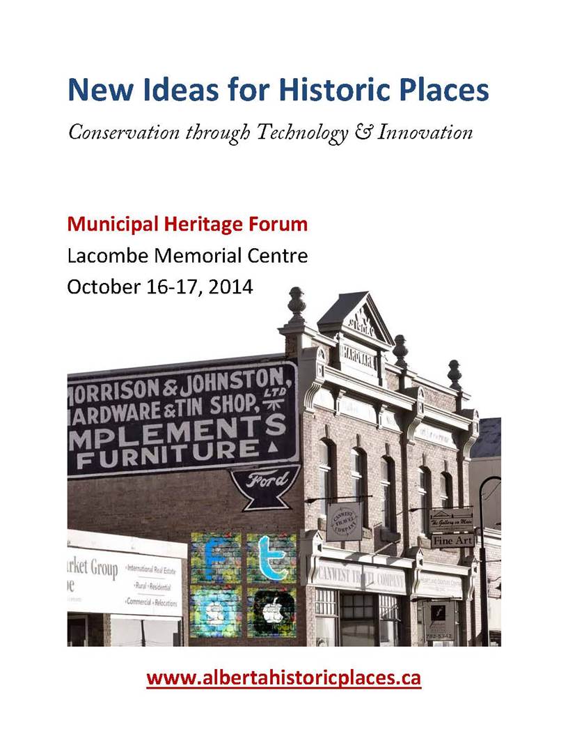
As previously announced, the 2014 Municipal Heritage Forum will be held on October 16th and 17th at the Lacombe Memorial Centre with sessions to be held in and around their award winning Main Street. The theme of this year’s forum is “New Ideas for Historic Places: Conservation through Technology and Innovation”. We are planning some exciting sessions to get you thinking about social media, mapping and documentation as well as workshops on using technology for building conservation. We hope to see you there! Registration will open and keynote speakers will be announced in June.
(Note: social media graffiti not actually real!)
For those of you who have attended past Forum’s you will be familiar with the Municipal Show and Tell sessions. Show and Tell is an opportunity for municipalities and volunteer groups to present projects they have been working on to their peers. It is a great way to learn about different heritage initiatives and to make valuable contacts for the future. The challenge we always have organizing Municipal Show and Tell is that you heritage conservationists are a humble group – many of you don’t realize how interesting your projects are and how much others can learn from you. Year after year we get feedback telling us how valuable the Show and Tell is to participants so we strongly encourage you to send us your ideas or recommendations! Presentations are approximately 15 minutes long, with time for questions included. If you would like to forward an idea for the Municipal Show and Tell e-mail us at albertahistoricplaces@gov.ab.ca.
This slideshow requires JavaScript.
Written by: Rebecca Goodenough, Municipal Heritage Services Officer
The Town of Sexsmith is now one step closer to completing their first Municipal Heritage Inventory. On April 30th the Town, in partnership with project consultant Donald Luxton and Associates Inc., held a public open house to present information on the Heritage Inventory project to the community. Approximately 14 residents attended the session to review possible themes related to the development of their community and to provide information on specific buildings.
The following day the Town’s Heritage Advisory Board (HAB) met to review the proposed Statements of Significance for 16 potential locally-significant historic resources within Town boundaries. Their local knowledge of the people and events from Sexsmith’s past provided the project consultant with valuable information. Revisions will be made to the Statements of Significance and we anticipate the final report will be presented for review by Town Council by the end of summer.
Participants in the Sexsmith Heritage Inventory Project (From left to right): Chelsea Dunk (Donald Luxton & Associates Inc.), James Obniawka (HAB), David Olson (resident), Larry Anderson (HAB), Vella Anderson (HAB), Carolyn Gaunt (Town of Sexsmith), Jean Rycroft, Sam Boisvert (Donald Luxton & Associates Inc.). Missing from photo: Grant Berg, Isak Skjaveland
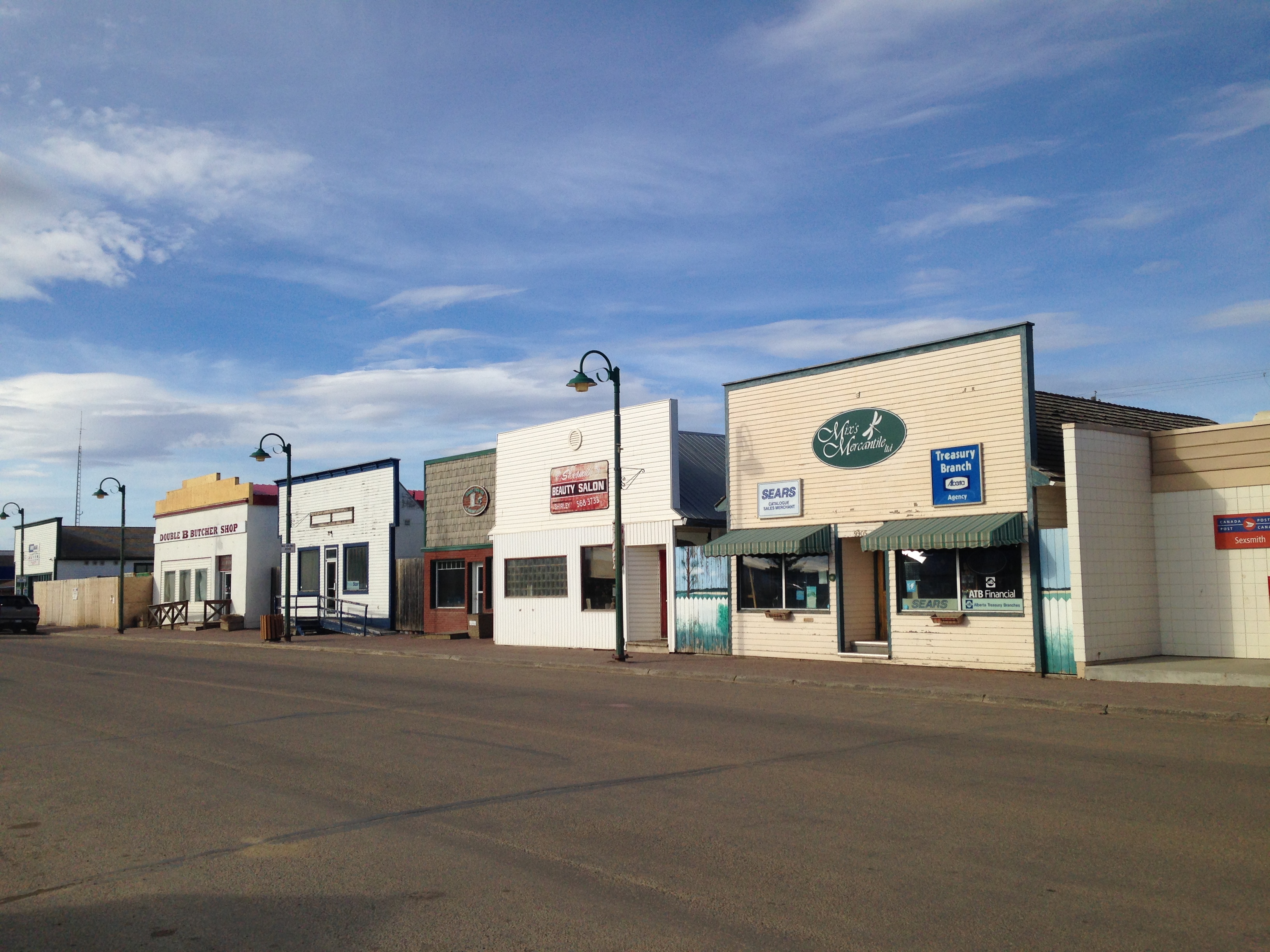
Originally known as Benville, Sexsmith was first settled in the early 1900s but experienced growth following the establishment of the ED&BC railway in 1916. The proximity of the community to the rail line caused expansion of agricultural production and established Sexsmith as a major hub for grain export. Sexsmith was once known as ‘The Grain Capital of the British Empire’ during the 1920s and 30s and at one time there were nine grain elevators situated adjacent to the railway. Today three remain and the Town is in the process of acquiring one for conservation purposes. The community is further characterized by its relatively intact boomtown commercial main street, located directly opposite of the rail line and by the presence of two Provincial Historic Resources: the Northern Alberta Railway Station and the Sexsmith Blacksmith Shop.
100 Street (Main Street), Sexsmith
Heritage inventory projects are supported by the Municipal Heritage Partnership Program and provide municipalities with the process and tools to assess possible historic sites within their boundaries for future municipal historic resource designation.
Written by: Rebecca Goodenough, Municipal Heritage Services Officer
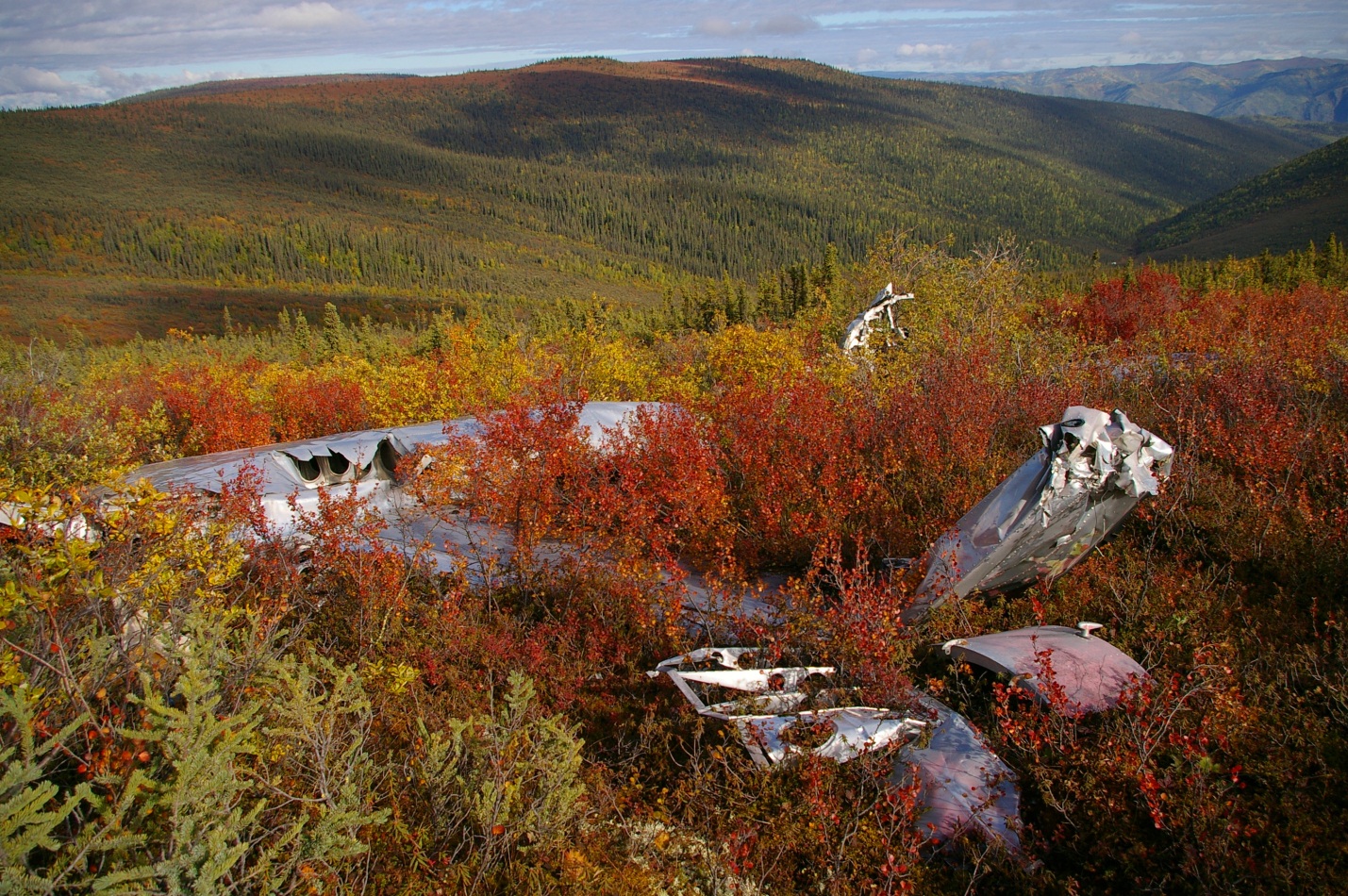
Plane wrecks are unique and dramatic physical records of human movement. We document here the archaeology and history of a 1952 B-17 plane crash to help illustrate the deep and fascinating roots of northern aviation. We reconstructed mission details from accident reports and discovered interesting connections to the famous Northwest Staging Route, which was a significant transportation network that spanned Alberta.
Scale of the SB-17G and the 8 crew members on the ill-fated 1952 flight (diagram T. Kristensen).
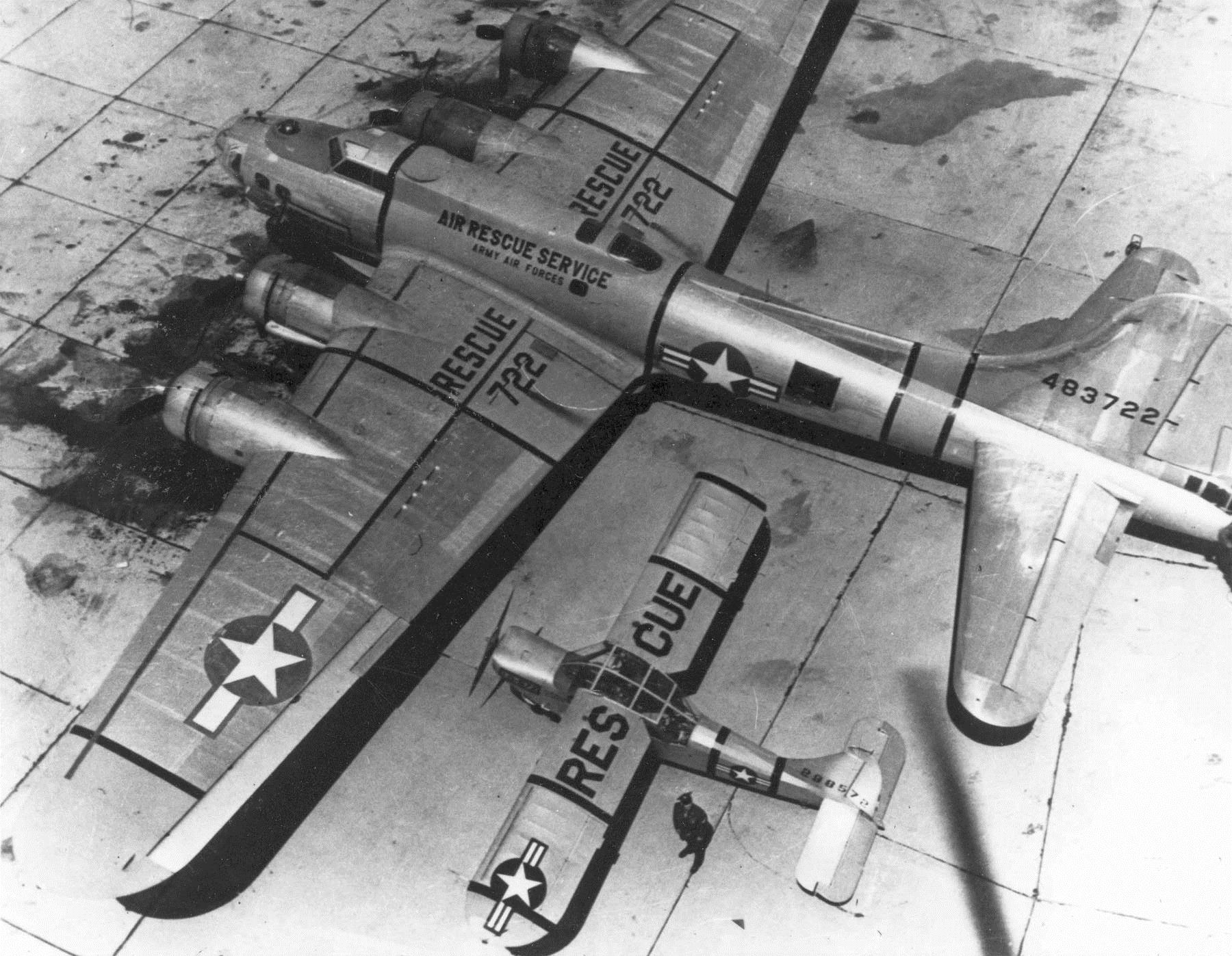
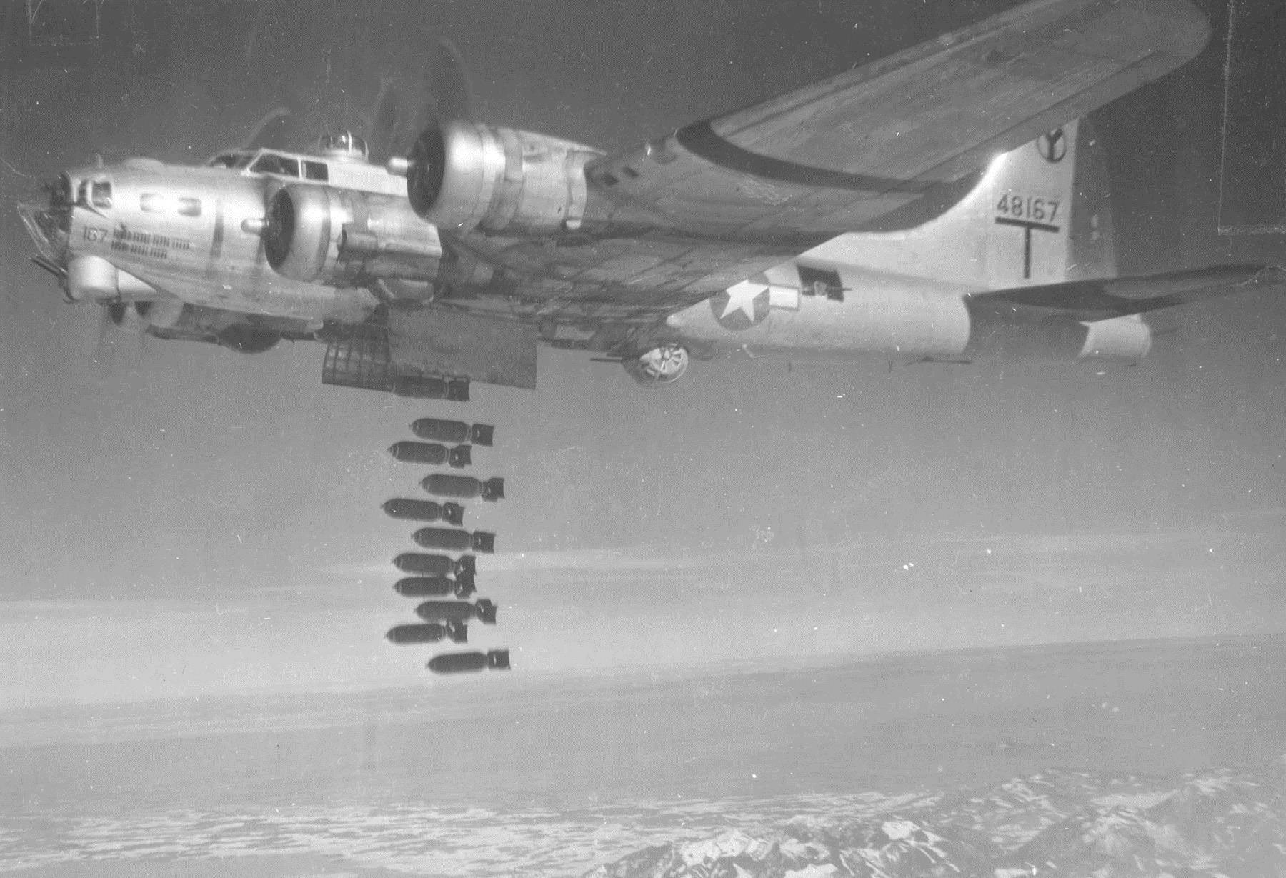
On July 11, 1952, a modified B-17 (an SB-17G) set out from Alaska on a search mission in the Yukon to locate a crashed Royal Canadian Air Force plane that had disappeared in June. The B-17 was originally a Second World War era high altitude bomber, legendary for the damage it could endure in combat. Its durability, combined with the availability of surplus aircraft after the war, meant that B-17s were used for many post-war activities including weather survey, forest firefighting, and search and rescue.
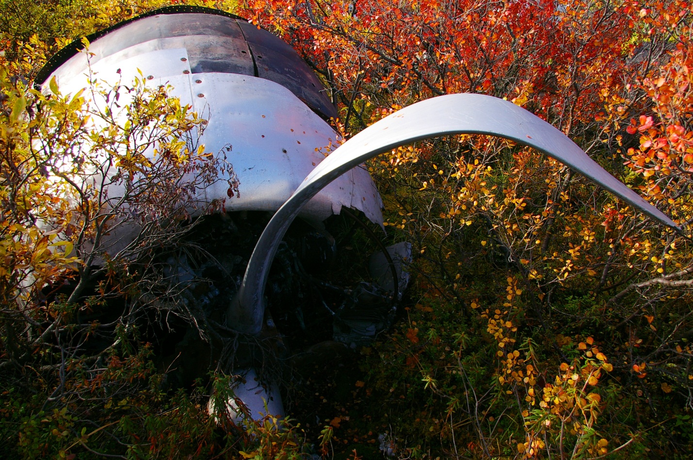
Mountainous terrain in which the SB-17G met its untimely fate (photo T. Kristensen).
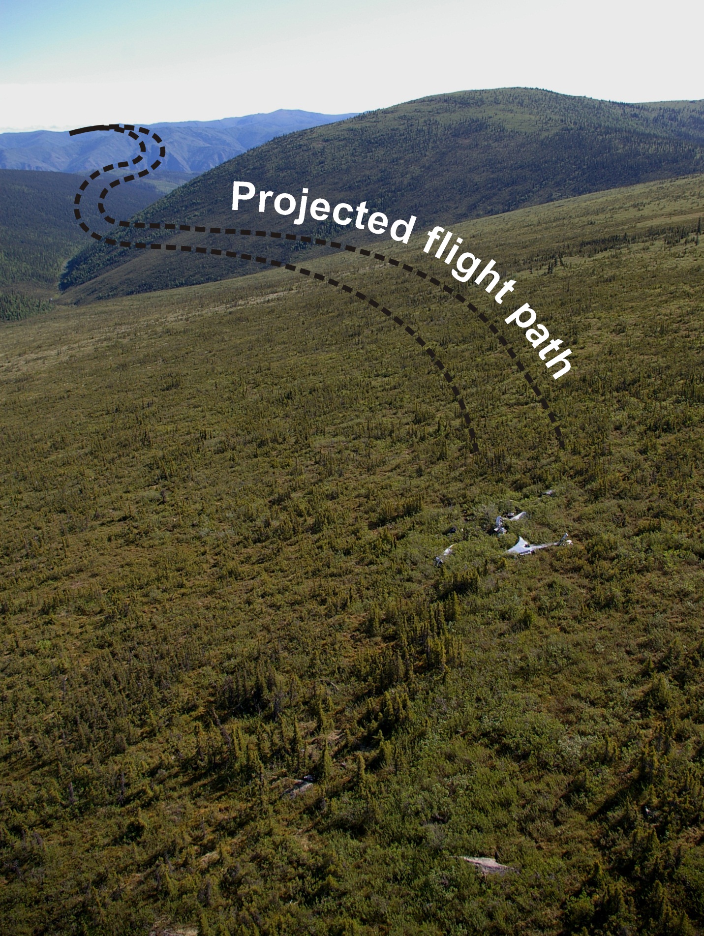
Eight crew members of the United States Air Force 10th Air Rescue Squadron were aboard the SB-17G as it entered a small mountain valley. The navigator was unfamiliar with local topography and 15 seconds into the valley, the crew began adjusting power in an attempt to avoid a fast approaching valley wall. Because of its original purpose in high altitude flight, the SB-17G was not particularly maneuverable and couldn’t recover from its predicament. Stalling within meters of the ground, the left wing struck an alpine slope sending the aircraft into an arching skid path that tore through birch trees and bedrock cobbles for several hundred meters before coming to rest. The wreck was quickly consumed by flames. Five men evacuated immediately but the remaining three caught fire in their frantic attempts to depart. An heroic lieutenant escaped the wreck and pulled one man to safety while another emerged from the wreck engulfed in flames. Although he was immediately doused, the airman couldn’t recover from severe burns and died six hours later. The crew spent a somber night in the cold mountains before being rescued the next day.
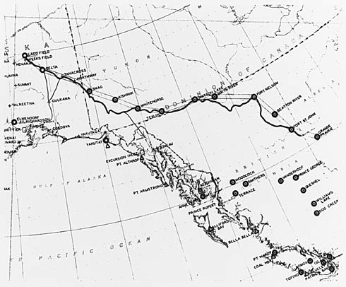
Northwest Staging Route in Canada and Alaska. Yukon Archives. Department of Defence Collection, 91/37 #51, PHO 419.
The story of the SB-17G crash represents a small but significant piece of aviation history. Northern aviation assumed an international importance with the growth of the Northwest Staging Route in the 1930s. The Canadian portion began in Edmonton and linked a series of northern airstrips up to Alaska and Russia. Like Edmonton, most towns along the route were initially First Nations gathering spots that developed into fur trade posts when traders arrived. They eventually grew into agricultural, mining, forestry, or oil and gas centres. The Alaska Highway was built to connect these centres to help protect North America from a potential Pacific attack. After the war, the Northwest Staging Route remained important for military exercises (which drew the SB-17G to the Yukon) and as a transportation route to other international conflicts.
Reconstructed flight path of the SB-17G to its final resting spot (photo T. Kristensen).
Given their experience on the land, First Nations people were hired as guides to help survey the Alaska Highway before construction. Consequently, much of the highway followed First Nations trails that existed for millennia. Other portions followed Gold Rush trails that started to criss-cross the north in the late 1800s. This synopsis illustrates how modern transportation systems in the north have deep histories. The interconnected travel network that now links northern towns has witnessed birchbark canoe paddlers, moccasins, Gold Rush wagons, tank treads, and jet streams.
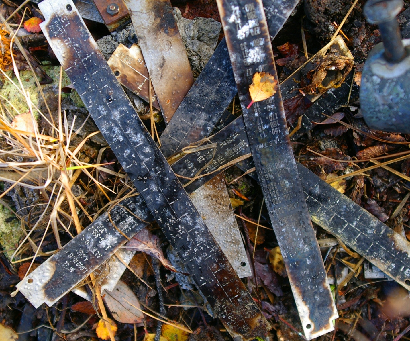
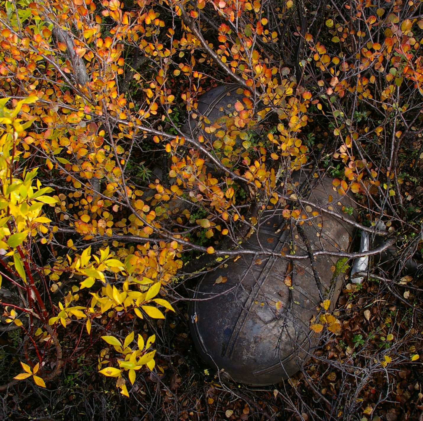
SB-17G (S/N 44-83722) used in the US Military Air Rescue Service (photo credit 060526-F-1234S-009.jpg, National Museum of the US Air Force).B-17G-50-VE (S/N 44-8167) during in-flight high altitude bomb drop in WWII (photo credit 050610-F-1234P-011.jpg, National Museum of the US Air Force).B-17F flying fortress formation in WWII (photo credit 050615-F-1234P-006.jpg, National Museum of the US Air Force).SB-17G propeller and engine (photo T. Kristensen).SB-17G gear wheel (photo T. Kristensen).Charred measurement tags from SB-17G (photo T. Kristensen).Canister from SB-17G (photo T. Kristensen).Wreckage of the SB-17G overlooking the valley it was unable to climb (photo T. Kristensen).
Territorial and provincial heritage legislation exists to preserve the remains of historic events like the SB-17G plane crash. A research permit is required to excavate any historic resource be it a 2 million year old fossil, a 2000 year old fishing camp, or a Second World War era aircraft. Historic objects are not permitted to leave the territories or provinces unless authorized by respective governments, which means artifacts can’t be re-located without permission. This legislation has created some conflicts in the past between heritage managers and people interested in salvaging plane wrecks but positive relationships and advance communication can help ensure that aviation historians and archaeologists work together to share their passion for the past. The story of the SB-17G crash highlights the military importance of the north and the historical depth of human movement.
Written by: Todd Kristensen, Northern Archaeologist & Mike Donnelly, Archaeologist.
Curling rinks, long low windowless buildings popped up in towns and hamlets, as each community grew. Inside were sheets of natural ice, 146 feet long and between 14 and 15 feet wide, marked out with lines and the target (called the house) for the rocks or stones as they are also known. Old curling rinks were cold places, but that was exactly the point—they had to be. In 1953 avid curlers in the small farming community of Conjuring Creek, south of Calmar, built a natural ice rink using straw bales for insulation. When someone unsuccessfully tried to buy the stack of bales, the rink became known thereafter as The Straw Pile!
The straw pile, date unknown. (Photo is courtesy of the Conjuring Lake Curling Club.)
Albertans were already avid curlers by the late 1880s with clubs in Edmonton, Fort McLeod, Banff and the mining town of Anthracite. By 1902, Edmonton had a club with a three sheet indoor rink and 100 members. Vegreville curlers began on a pond in 1907; a year later they builit a three sheet indoor rink.
The introduction of mechanical ice plants to make artificial ice for curling rinks was a major change for the sport. Ice could be kept at the ideal temperature -5° (Celsius) to -3° with an ambient temperature of 4° at chest height. Artificial ice came to city centres first, although Claresholm, plagued by chinooks, installed an artificial ice plant in their rink in 1952. Vegreville opened a new professionally engineered and constructed a six-sheet artificial ice rink in 1955 at a cost of $80,000.
Just as artificial ice was gaining momentum, the Conjuring Creek Curling Club was formed. Lumber was pricey, so Club members decided to build with straw bales, a tried and tested construction method for curling rinks. Square straw bales made thick walls which provided good insulation to control rink temperature. The bales were lined up, and spruce posts were spaced along their length to keep the bales together. The exterior walls were covered in wood slabs, and the rink was wired and lit by a generator. The first Straw Pile proved to be temporary, and in 1956 a new building was erected. Straw bales were used again, but this time the Club sprang for exterior siding and also lined the interior walls. The rink was bigger, with 2 sheets of ice. Further improvements in 1973 included fluorescent lighting and comfy red bench car seats in the viewing area.
The mural painted in the Calmar Curling rink to commemorate the Conjuring Lake curling Club. (Photo courtesy of the Conjuring Lake Curling Club.)
Preparing the ice took time. Sawdust was spread to the edges of the bale walls against the advice of B.E Olson, whose 1929 pamphlet The Art of Making True Curling Ice noted it was not a good conductor of cold and was inclined to go mouldy in spring. The rink was flooded in layers slowly and evenly; if it was too cold during flooding the ice would crack and peel off. At the right level the surface was planed with a homemade scraper, and then a scriber, a board with saw-teeth spaced to mark the rings of the house, was used to etch the ice. A hole made in the centre of the house to anchor a measuring stick for use during play. The water pumped from nearby Conjuring Creek was a little yellow so powered milk was added to whiten the ice, until it was decided to tank water in. The hacks for placing a player’s feet were frozen into the ice as the flooding progressed. The coloured lines and rings were painted on using paint mixed with oil and then frozen over, and finally the ice surface was pebbled. Closing the doors and turning off the lights in between games kept the rink cold.
An ice pebbler, one of the Conjuring Lake Curling Club artifacts donated to the Alberta Sports Hall of Fame. It was invented by E.B. Olson, who founded Olson Curling Supplies, in Edmonton in 1933. Pebbling involves sprinkling warm water on the surface of the ice to give some grip for the rocks; if the ice was completely smooth it would not be possible to “curl” the stones. (Photo by Judy Larmour, Courtesy of the Alberta Sports Hall of Fame.)
The Conjuring Lake curling rink was a community gathering place. Part of the fun was preparing the ice and the social aspect of curling included cheering from the viewing area, which eventually hosted 5 generations of eager spectators. The first prizes included jam, cigarettes, eggs and chocolate! Trophies came later. By 2010, however, it was no longer viable to keep the rink going and it was demolished, the straw pile burned in 2011. It’s not known how many natural ice rinks were built using straw bales in Alberta, but Conjuring Lake rink was probably the last one in use. We hope to be proved wrong—is there yet one more quintessentially prairie ice rink out there somewhere?
As Manager of the Historic Places Research and Designation Program, Brenda Manweiler heads what may be the unit with the greatest variety of responsibilities within the Historic Resources Management Branch. Brenda joined the branch as a Municipal Heritage Services Officer in 2009, after working for museums, British Columbia’s Heritage Branch, and Parks Canada. She has been in her current position since April 2013.
Brenda Manweiler, pausing for a moment during a busy day.
She now heads a six-member team of historians and heritage specialists. The unit’s primary role is administering the Provincial Historic Resources Designation Program (described below). But there’s much more!
In addition, her group provides ongoing advice on how best to address the impact on historic structures (that are not designated) in cases where they may be affected by development in Alberta. This is part of an integrated regulatory function that Alberta Culture administers for the preservation of historic resources.
Members of her staff provide research services to many of the historic sites operated by the Historic Sites and Museums Branch of Alberta Culture. Their services help, for example, to develop exhibits at these sites.
As well, this unit is responsible for the Foundation’s Heritage Markers Program. This program supports the development of heritage markers that promote awareness of the historic people, places, events, and themes that have defined the character of the province. The markers are ideally sized for placement within parks, along trails or sidewalks, and in other community locales. Once the topic of a new marker has been selected, unit staff members develop the text, select photographs, and are responsible for coordinating the design, fabrication, and installation of the markers.
The unit includes the coordinators for two other programs, as well:
What kind of historic places are “out there” in Alberta?
The Coordinator of the Alberta Heritage Survey Program oversees a database of information about non-archaeological historic resources across the province. The Alberta Heritage Survey was established in the mid-1970s, has information dating back to 1971, and is being continually updated. Entries about individual resources include photographs, details of architectural characteristics, history, designation status, and location. This information comes from heritage surveys of neighbourhoods or building types, many of which have been commissioned by municipal governments and conducted by consultants and heritage groups. Today there are almost 100,000 individual resources documented on a searchable online database.
How do Geographical Features Get Names?
The Coordinator of the Geographical Names Program manages the process to formally name geographical features in Alberta. Names are chosen in accordance with international standards and guidelines, with preference usually given to names that have a demonstrated local and/or historical usage. The coordinator’s work includes communicating with governmental organizations from the municipal to international level, disseminating geographical names information from both popular and scholarly sources, maintaining records, and conducting related field and archival research. All this leads to making a recommendation on a name to the Alberta Historical Resources Foundation board and the Minister of Alberta Culture.
How do places get designated?
The Historic Places Research and Designation Program’s largest responsibility, however, is the Provincial Historic Resources Designation Program, which identifies, evaluates, and designates those historic resources that are most significant to the province as a whole. Resources eligible for consideration include structures, archaeological sites, palaeontological resources, and other works of humans or nature that are of value for their historic, cultural, natural, scientific, or aesthetic interest.
Once a resource is designated, its owner cannot destroy, disturb, alter, restore, or repair it without written approval from the provincial government. But the owner gains tangible benefits, including access to conservation grants and technical advice, and the intangible benefit of knowing that a valued property will be preserved and protected into the future. Currently there are some 360 sites protected as Provincial Historic Resources in Alberta.
Owners or advocates interested in obtaining heritage designation for a property often start by contacting Brenda for advice. She’ll ask questions to determine if the property is eligible for consideration, and to gauge whether designation should be pursued at the provincial or municipal level, or both. Occasionally one of the branch’s Heritage Conservation Advisers will make a site visit to answer property owners’ questions and assess the potential eligibility of their property for designation.
Once an application is received, Brenda administers the evaluation process. The Designation Committee, made up of her staff plus staff of the Heritage Conservation Advisory Services unit, meets about every six weeks to confirm the eligibility of new applications and to monitor the progress for sites currently under study. The Designation Committee works to determine if the site has heritage significance (according to five specific evaluation criteria), and a Heritage Conservation Adviser studies the site to determine if it retains enough integrity to communicate that significance. Much archival and onsite research is required to complete an in-depth evaluation. If the committee recommends designation and that is approved at a higher level, the owner is informed and his or her support is obtained, a designation order is signed, and the site is listed on the Alberta Register of Historic Places, an online database of all designated historic resources in Alberta.
Benefits of Designation
Why would owners want their properties designated? Brenda explains: “They believe that they have a property that’s of significance. They want to keep it around so that future generations can enjoy it and benefit from it, so that it can continue to be a part of the communities that they live in. Also, the Alberta Historical Resources Foundation provides conservation grants to property owners of designated resources, which serves as a fantastic incentive for people to conserve their property for the long term.”
There have been about five new applications since Brenda started in her position nearly a year ago, so she estimates that five to ten per year would be the norm. Her team is currently working through the evaluation process for approximately twenty sites.
So Brenda’s job involves lots of paperwork and administrative management. But she never loses sight of what it’s all for: “So many people work in this field because they feel passionately about the buildings, and I’m certainly no different there,” she says. “But for me, so much of it comes down to the people: the applicants, the owners, the community members. The public is so passionate about the sites that they so want to see conserved. I love being able to work with the public to help them reach their goals of contributing to a legacy for Alberta.”
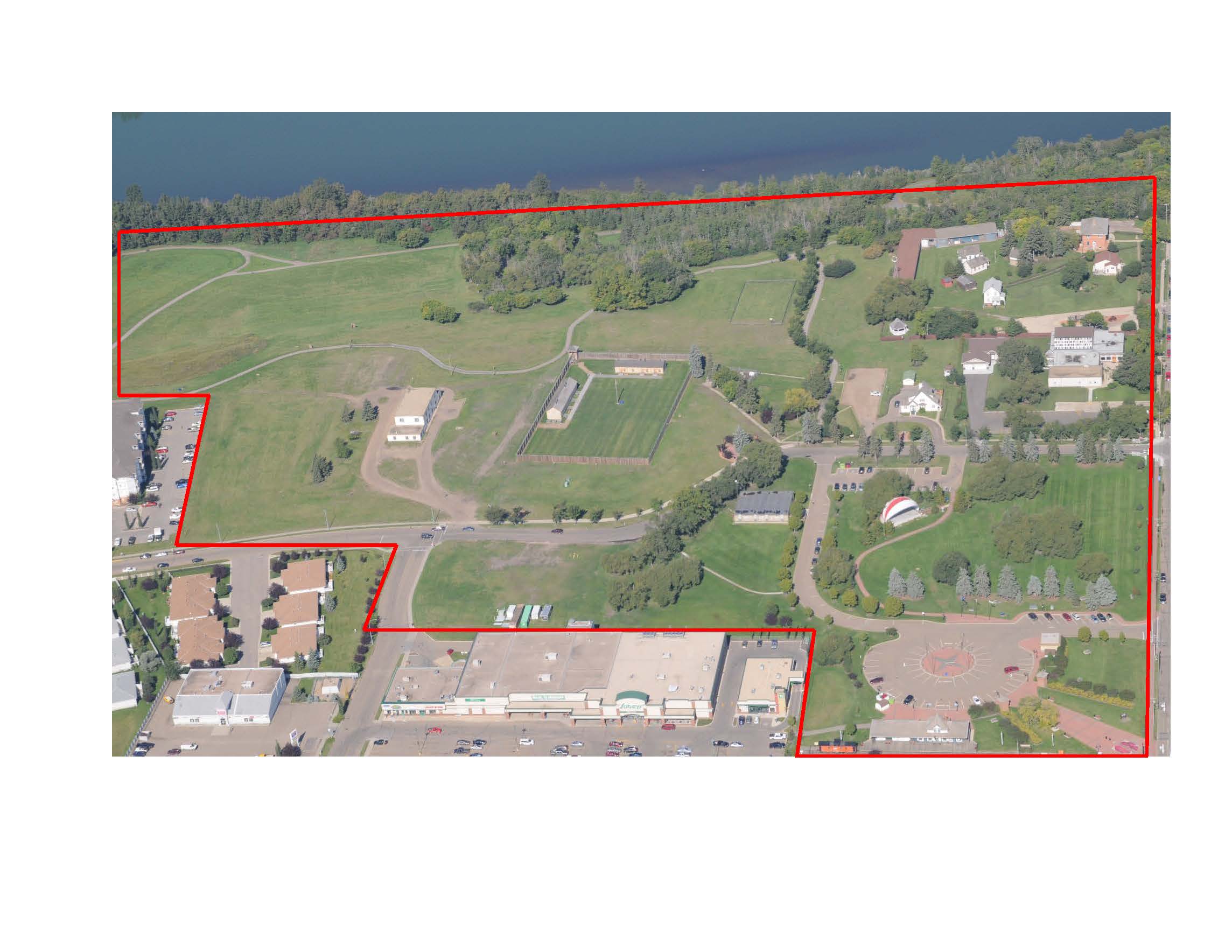
The City of Fort Saskatchewan is one step closer to realizing their vision for the development and interpretation of a significant community amenity through Council’s recent approval of the Historic Precinct Site Master Plan Guiding Document. Located adjacent to the City’s downtown and along the edge of the North Saskatchewan River, the Historic Precinct provides a unique opportunity to showcase the cultural history of Fort Saskatchewan and to develop a space for public learning and enjoyment.
Historic Precinct Area
The Approach
The Historic Precinct contains an array of man-made and natural elements that contribute to the telling of the story of Fort Saskatchewan. Project consultants EIDOS Consultants Inc. and Marshall Tittemore Architects approached the conceptualization of the space as a cultural landscape, wherein:
“An important part of the Precinct’s heritage value is found in the relics of law and order and public works, including buildings, structures, sightlines, earth mounds, plant materials and features that remain in situ. These relics constitute part of the heritage value of the area by providing tangible evidence of how it was transformed and used by the NWMP, Canadian Northern Railway, the Province and the City.” (Historic Precinct Site Master Plan, page 9).
The planning process sought to integrate local values into the final plan and therefore included public and stakeholder consultation through surveys, open houses and workshop sessions.
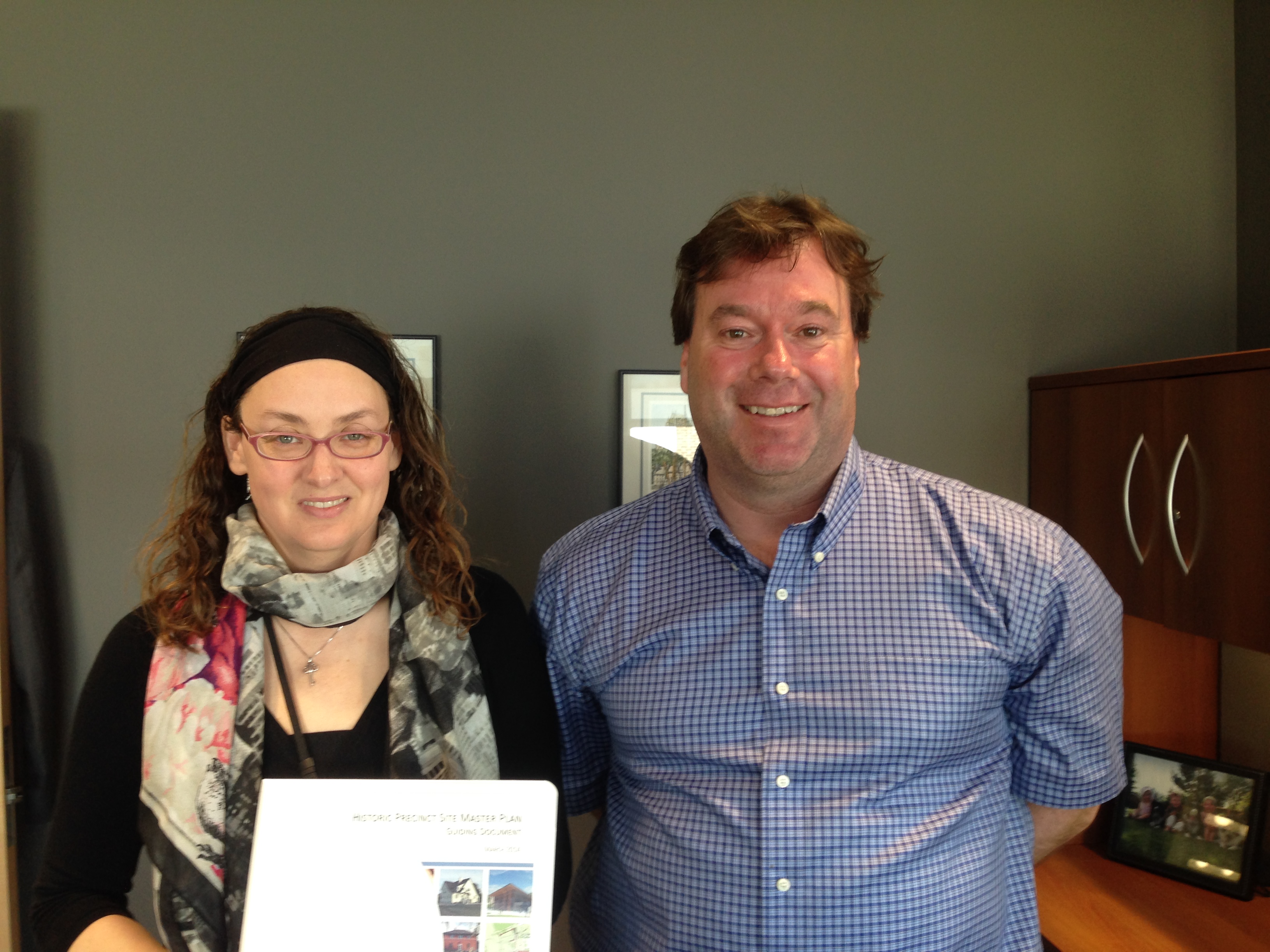
The City of Fort Saskatchewan’s Diane Yanch, Culture & Historic Precinct Supervisor and Richard Gagnon, Director of Culture Services display a copy of the completed Historic Precinct Master Plan
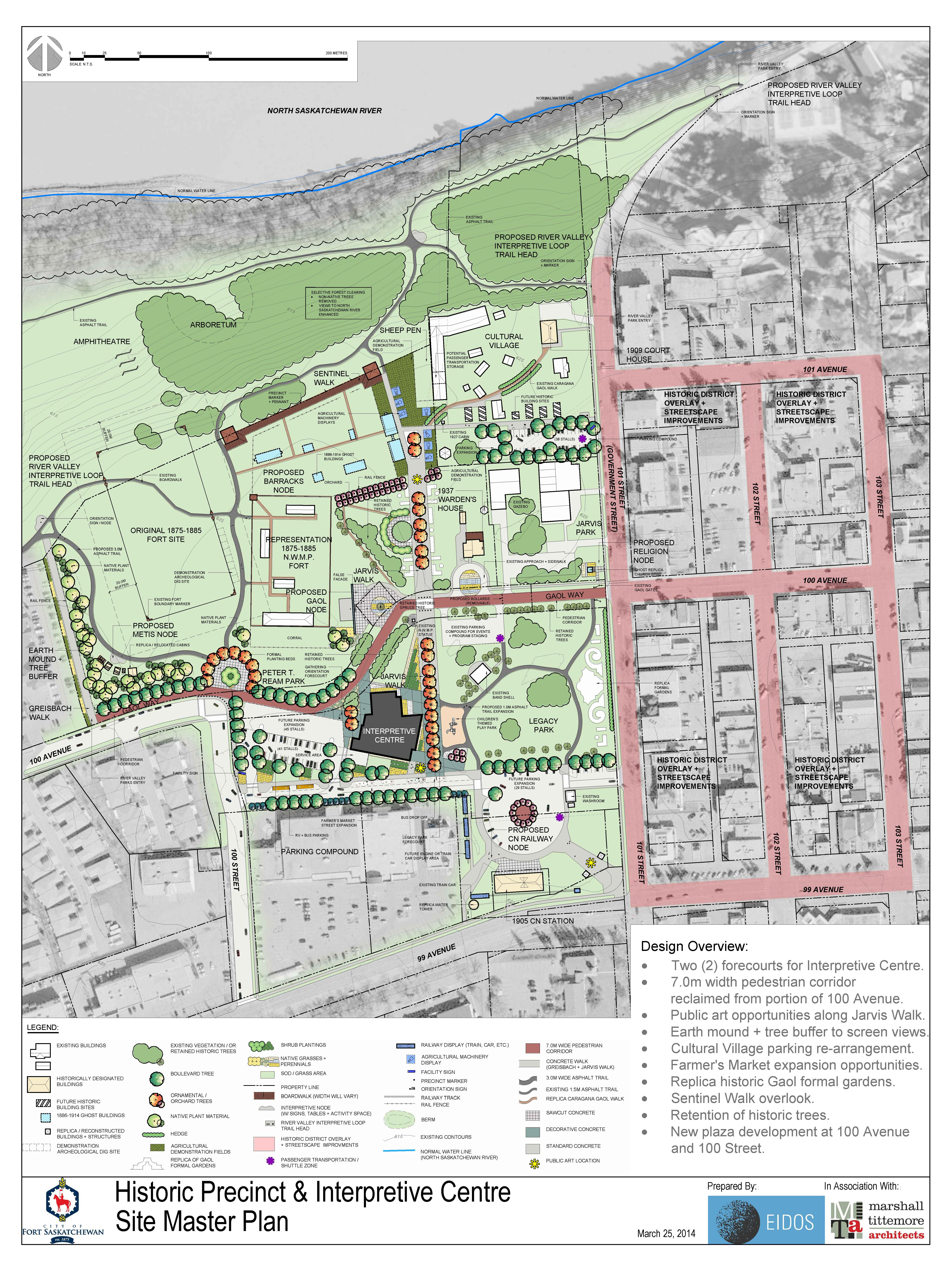
The Master Plan
The Master Plan involved considering the long-term development and interpretation of the historic precinct, including integration of existing Provincial Historic Resources, recommendations for pedestrian circulation and way-finding, interpretation opportunities and development of a conceptual design for a new Interpretive Centre. A detailed phasing plan was also provided to allow the City to structure implementation in a coordinated and cost-effective manner.
Historic Precinct Site Master Plan
The uniqueness of the site is exemplified by the existence of three Provincial Historic Resources within its boundaries including the North West Mounted Police Post, the Fort Saskatchewan Museum (Courthouse), and the Canadian Northern Railway Station. These three historic resources are proposed to be key elements in the interpretation and programming of the Historic Precinct and are considered as Historic Precinct Nodes in the Master Plan.
Original 1875 Fort Site Node – This Provincial Historic Resource is presently an open native grass field and will remain untouched during development, with the long term goal of undertaking small scale research and public archaeology programs in partnership with interested academic institutions, archaeological societies and the Province of Alberta.
Fort Saskatchewan Museum and Cultural Village Node – The Fort Saskatchewan Museum (Courthouse) is a designated Provincial Historic Resource. The Master Plan calls for the land surrounding the Courthouse to be utilized as a ‘cultural village’ in which historic buildings and artifacts will be displayed.
Railway Node – The CNR Station will continue to be space for use by community groups. The area around the Station will be enhanced to include an opportunity to showcase other rail infrastructure, landscaping and opportunity to enhance access to the adjacent Legacy Park and farmer’s market plaza.
Other Historic Precinct Nodes proposed within the plan include a Gaol Node, Religion Node, MétisNode and First Nations Node.
Next Steps
The City will continue with planning the programming for the future Interpretive Centre with hopes of breaking ground by the end of 2014. Conservation Plans have been prepared for the Courthouse/Museum and CNR Railway Station to ensure that on-going improvements and maintenance are consistent with accepted conservation practices. In accordance with the terms of designation, approvals will be obtained for any projects within the site that will affect the Provincial Historic Resources as well as work in the vicinity of the NWMP Police Post due to the high archaeological potential of the site.
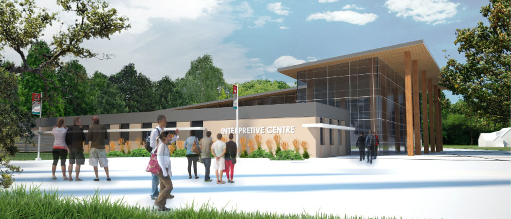
Proposed General Concept Design of the Interpretive Centre
The Historic Precinct Master Plan was partially funded by the Alberta Historical Resources Foundation under the Heritage Management Plan grant category of the Municipal Heritage Partnership Program. Though Heritage Management Plans typically take the form of a document that outlines policy and a process for municipal designation, the grant category is flexible and can apply to projects that involve planning and policy development for the stewardship of historic resources more broadly. The Historic Precinct Site Master Plan is an example of how the program can be tailored to meet the unique needs of municipalities.
Written by: Rebecca Goodenough, Municipal Heritage Services Officer
Anna Curtis heads up the Historic Resource Management Branch’s Land Use Planning Section. If proposed development projects in the province could potentially impact historic resources, the Historical Resources Act allows the Minister of Alberta Culture to require the project proponent to perform studies or other work before their projects can proceed. “What we do is coordinate [the regulatory approval process],” Anna explains.
Anna Curtis, Head of Land Use Planning, working at a site in the Cypress Hills.
As Anna puts it, the Land Use Planning Section is on the “front line” of the Historic Resources Management Branch when it comes to communicating these requirements to the proponents of development. Land Use Planning receives plans from proponents and determines which part of Alberta Culture—Archaeological Survey, Aboriginal Heritage, Royal Tyrrell Museum of Palaeontology, or Historic Places Stewardship—might need to review the plans to assess if approval should be conditional, requiring that the proponent first complete a study or undertake some action to mitigate the potential impact to a historic resource. If so, Land Use Planning then “translates” the technical language into a regulatory order for the proponent. As Anna puts it: “We aren’t the authorities, we don’t make those decisions [about how best to mitigate or offset the effects of development]—what we do is coordinate what everybody else says, and put it into a format that is both an order to the proponent and [something] the proponent will understand.”
Coordinating the Protection of Historic Resources
Because Land Use Planning acts as a central coordinator, the different sections of the branch can concentrate on their specialties without needing to worry about presenting a comprehensive requirement for the proponent to follow: Land Use Planning synthesizes the different sections’ points of view. Anna explains, “Managing the project is what we’re all about. We’re the central point. The archaeologists don’t necessarily have to know what the palaeontologists want—that’s our job.” She has been the Head for not quite two years. Previously, she worked at the Royal Tyrrell Museum, doing land use planning in palaeontology. For the last ten years, she worked with the federal government in an Aboriginal relations and consultation capacity. All four areas that Land Use Planning covers (archaeology, palaeontology, Aboriginal traditional use, and historic use [structures]), Anna has covered in her personal background—meaning that she’s well-equipped to head up her section’s mandate to synthesize and communicate the different sections’ requirements.
Heritage Conservation and Development are (usually) Compatible
Because Land Use Planning is on the front line, the section also handles many of the questions that come in from the public about the branch’s work. Sometimes citizens call because they want a particular project in their area stopped. “There’s a lot of concern with certain types of developments, such as gravel pits” says Anna, giving an example, “…and a lot of people don’t want those developments near them in their area. So a lot of times we’ll get calls, with people wanting to know if we can stop developments. That is not the Historic Resources Management Branch’s role, Anna remarks. “That’s not what the [Historical Resources] Act is for. It’s not to stop development. It’s [about] how do we preserve and protect [historic] resources while allowing development to happen.”
Occasionally, though, a particular historic resource is deemed far too valuable to allow development to impact it. This was the case with the Quarry of the Ancestors, a significant stone-quarrying and tool-making site for pre-contact native peoples, situated in the middle of the oil sands. “It’s a big deal when you remove part of an oil sands lease out of production,” Anna notes.
But most of the time, rather than putting a halt to development, the Historic Resources Management Branch makes sure that studies are done so that information can be obtained about the site before development that may damage the historic resource is allowed to move forward. With all the development happening in the province, the branch is busy. The Land Use Planning Section helps the branch to stay ahead in several ways.
Anna’s section works with municipalities, so that their administrations understand what kinds of developments need to be reviewed. They also work closely with other Government of Alberta regulatory ministries and, of course, with different industry sectors, to identify projects with significant potential to impact historic resources. “We’re looking for those developments that are going to have a big impact,” Anna says. “For instance, we do a lot of work with…Alberta Transportation; they are big on gravel pits, roads, bridges—those are big projects in the province.”
Every Project is Unique
Land Use Planning also must keep informed about how different types of development affect historic resources differently. A pipeline that goes for hundreds of kilometres, Anna points out, causes a disturbance that is “long and linear. That’s a whole different thing than when you look at something like a gravel pit, which is more constrained in terms of area, but its impact can be quite extensive in terms of historic resources.”
Changing technologies also lead to different types of concerns. For example, open pit mining in the oil sands is now joined by the in situ process—using a series of wells placed in a row that inject steam into the earth and force the oil out of the sand. The impact of these wells on historic resources is wholly different.
The branch also sees “ebbs and flows in these kinds of developments with the commodity markets,” Anna says. When the demand for a particular commodity comes back strong after a downturn, often the technology for extracting that commodity has advanced. Consequently, Land Use Planning needs learn what kind of impact that these new technologies might have on historic resources. “We have to be flexible” in order to keep ahead of those changes, Anna says. “It’s a challenge because it’s a constantly moving target,” Anna remarks, “but it’s an interesting challenge.”
It’s not just heavy industry that the Land Use Planning Section has to take into account. The branch is currently seeing a great “increase in urban areas and the loss of native prairie, and a lot of that native prairie can have good potential [for containing historic resources].”
The Listing of Historic Resources
The Land Use Planning Section also assists to ensure that the Listing of Historic Resources is an up-to-date and effective tool for the branch. The listing is the provincial government’s database, identifying lands that contain or are believed to contain historic sites, including archaeological and paleontological sites, Aboriginal traditional use sites, and historic structures. “The HRMB updates [the list] every six months according to the work that’s been done,” Anna explains. If an excavated site is found not to be as significant as previously supposed, it may be given a lower priority ranking. This gives the branch a heads-up that other proponents in the same area might not need to perform extensive excavations. As new sites are discovered in the process of doing studies in an area, they are added to the list (and if research makes it clear that a site is of greater significance than previously thought, it can be given a higher ranking), so the branch will be aware that any development in the area is likely to require more in-depth studies before it can proceed. “The various sections use these studies to inform the branch’s decision-making process,” Anna says, and to be “conscious and mindful of the status of resources in the provinces. We don’t ask for studies for the sake of asking for studies.”
Alberta’s Historic Resources are Well Protected
“There is such good, strong regulatory oversight for historic resources in Alberta. It’s some of the strongest legislation in the country,” Anna concludes. “History is something that people always think of as an abstract, and this is tangible history. It’s satisfying to me to know that tangible history is not being lost—that we are making every effort to ensure that the most important sites are being protected and that we are extracting information.”
Plus, Anna reminds us, technology changes not only for extractive industries but also for those who unlock the secrets of our past. “Maybe ten years from now people will have different technology” with which to study historic resources, Anna says. “Suddenly we’ll have a whole other level of information that we didn’t have before.”
The Municipality of Crowsnest Pass contains the communities of Coleman, Blairmore, Frank, Hillcrest and Bellevue. Crowsnest Pass has a rich history in coal mining and trade unionism, and therefore, has much to offer in the way of historic resources.
20th Avenue, Blairmore
As a result of this rich and varied history, the Municipality has acknowledged the importance of identifying places of significance in the community. Given the breadth of possible historic resources within the municipality’s boundaries, Crowsnest Pass determined that a three-phase heritage inventory would be required to comprehensively assess potential sites. The first phase was completed in 2013 and inventoried 31 sites in the Coleman area. The second phase is being completed in 2014 and is looking at historic resources in Blairmore and Frank. The third and final phase will look at historic sites in the Hillcrest and Bellevue area and is proposed to be undertaken in 2015.
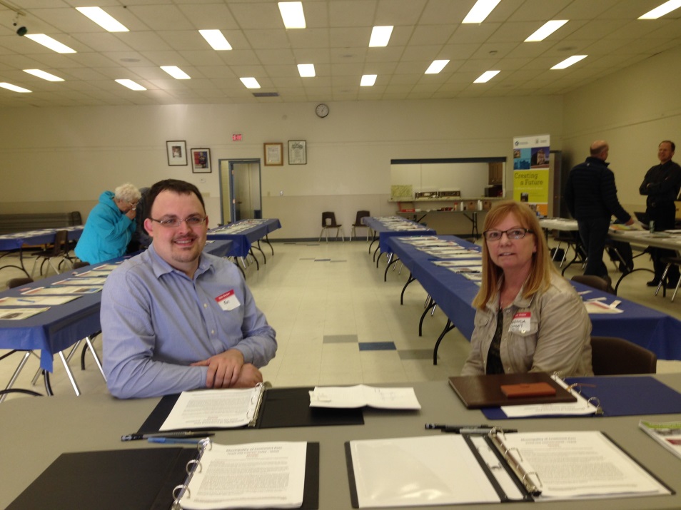
55 residents attended a public open house held on April 23rd at the Blairmore Elks Hall to provide feedback on possible sites to be included in the second phase of the heritage inventory. Consultants Community Design Strategies Inc. presented 65 possible historic resources for residents to provide feedback on in terms of historical information and opinions regarding the significance of each site. The results of the open house will be reviewed by the Crowsnest Pass Municipal Historic Resource Board and refined to a list of 45 sites for further evaluation. These 45 sites will have Statements of Significance prepared for them and will be presented back to the community for further review and comment at a second open house to be scheduled later this year.
Ken Bourdeau, Development Officer with the Municipality of the Crowsnest Pass and Merinda Conley, Principal with Community Design Strategies Inc. ready to speak with residents at the open house.
The event provided residents and property owners the opportunity to comment on the 65 places of interest and to speak with representatives of the Municipality of Crowsnest Pass, the Municipal Historic Resources Board and Alberta Culture about the heritage inventory project and municipal historic resource designation in general.
Heritage inventory projects are supported by the Municipal Heritage Partnership Program and provide municipalities with the process and tools to assess possible historic sites within their boundaries for future municipal historic resource designation.
Written by: Rebecca Goodenough, Municipal Heritage Services Officer
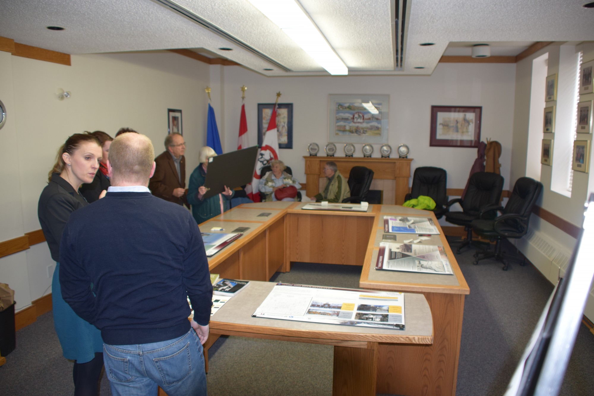
On April 16th I had the pleasure of attending an open house hosted by the Town of Raymond. They presented the penultimate draft of their historical context paper, drafted with the assistance of consulting firm Donald Luxton & Associates. The open house is the culmination of a process Raymond began with MHPP over two years. Several dozen people attended the event over the course of the evening and all were excited by the result of all this work.
Attendees discussing Raymond’s heritage.
The context paper outlines 16 themes (people or groups, or economic or social forces) that shaped the community and, by extension, the physical environment of the town. The context paper will help Raymond identify historic places: a place is locally significant, and therefore worth preserving, if it somehow reflects the influence of one or more of these themes.
While context papers do not explain the full history of a community, each one can provide a visitor (like me) with a glimpse of how a community evolved over time and Raymond’s is no exception. The town was formed by Jessie Knight who financed the purchase of land in the area, helped establish sugar beets as an important crop, and helped start a sugar refinery in Raymond. The community was settled by Jessie’s son Raymond Knight (the town’s namesake) and other members of the Church of Jesus Christ of Latter-day Saints. The town quickly grew to include members of a variety of faiths, including Japanese Buddhists as early as 1902.
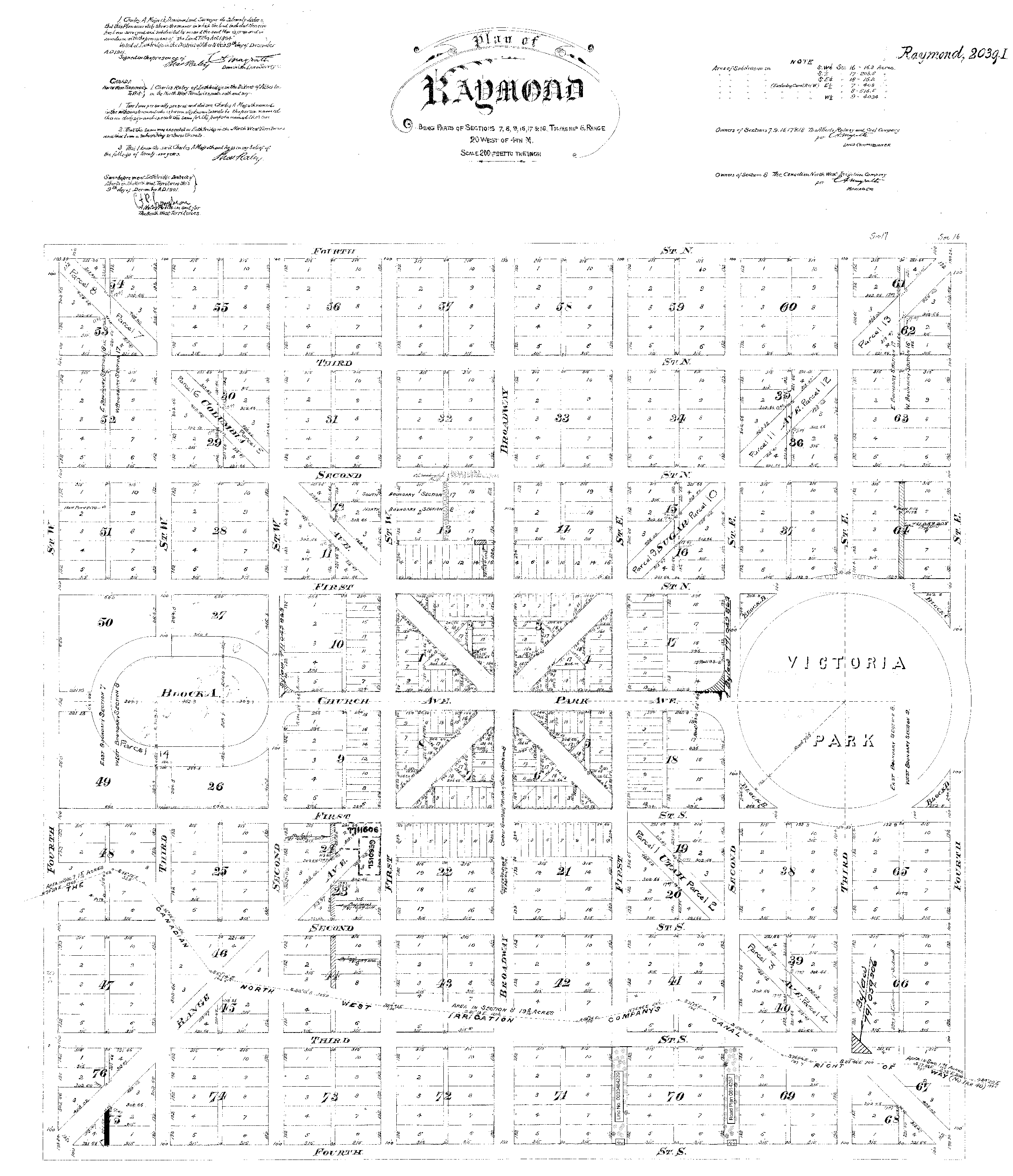
I was particularity fascinated to learn about the towns plan of survey, completed in 1901. It’s a unique combination of the urban planning ideas of the Church of Jesus Christ of Latter-day Saints and Georges-Eugène Haussmann, who redeveloped much of Paris in the 19th century. Haussmann’s plan for Paris—emphasising boulevards radiating out from central plazas—can be seen in the design of the central square and the radiating boulevards. Joseph Smith’s Plat of Zion—which emphasises large residential lots—is visible in the residential areas. The plan is unique, as far I know. Although it was never followed exactly, you can still see its influence in the width of the streets, the orientations of several buildings and the location of public buildings (like schools, the town hall and churches)
The original plan of survey for what would become Raymond
This project is scheduled to conclude shortly. We look forward to seeing what transpires as Raymond moves to begin identifying historic resources.
Written by: Michael Thome Municipal Heritage Services Officer.