Written by: Emily Moffat, Regulatory Approvals Coordinator, Archaeological Survey of Alberta
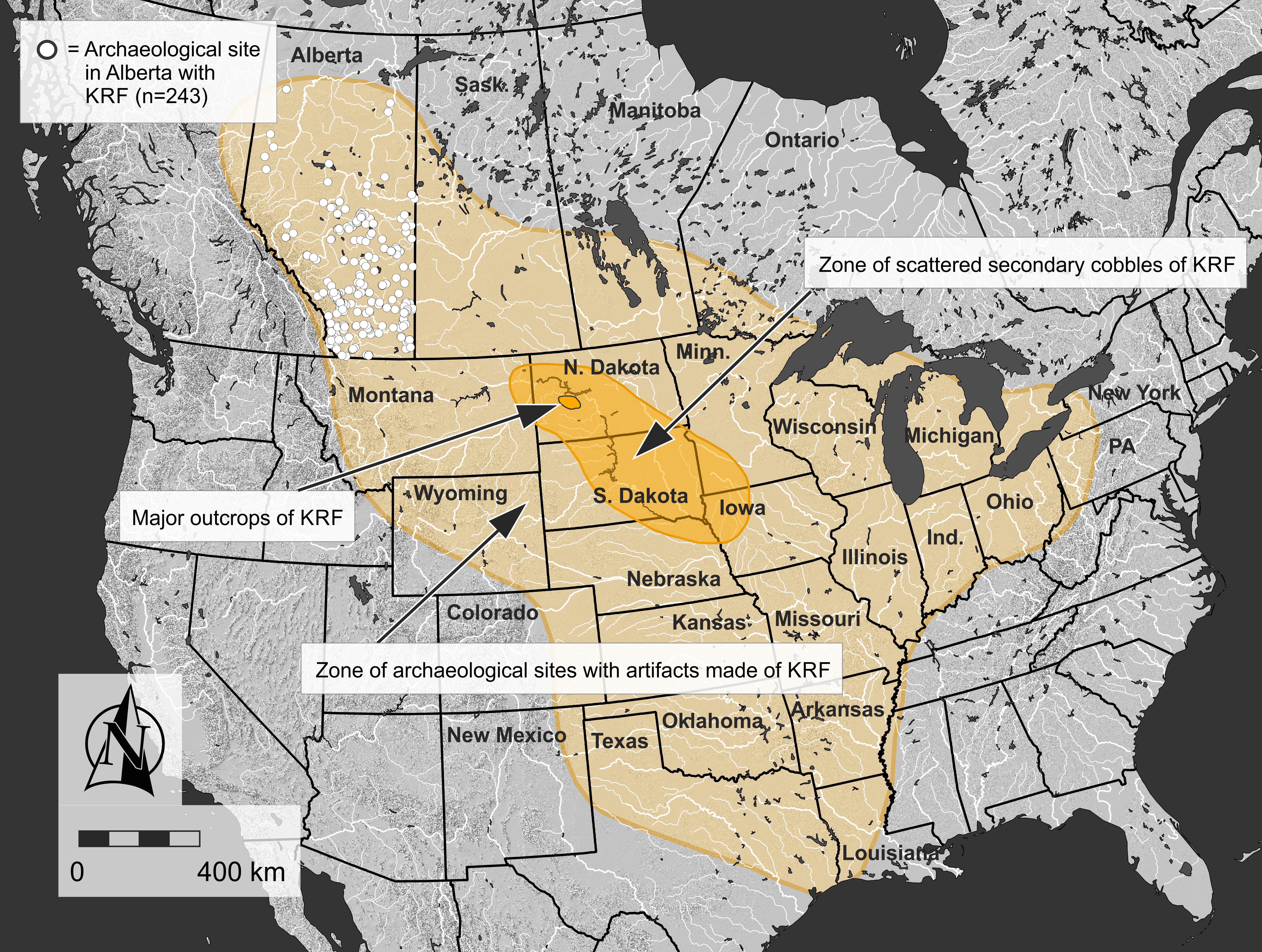
Stone tools were central to life in pre-contact North America and the rocks that they were made of were highly valued. The archaeological record throughout vast regions of North America, including much of Alberta, contains Knife River Flint (KRF), one of the most significant and intriguing tool stones used before the arrival of Europeans. KRF gets its name from the Knife River, a tributary of the Missouri River that flows through the United States Midwest and Southeast Regions.
In an era of limited human mobility compared to modern times, KRF was regularly transported hundreds of kilometres from its source in North Dakota, where it was quarried for thousands of years. A relatively small geographical region contains the majority of quarry pits and this location is the hub of KRF’s widespread distribution.
Map showing the major source area where Knife River Flint was quarried, the area where scattered cobbles were collected, and the overall extent of Knife River Flint artifacts based on published records. White circles show the extent of archaeological sites in Alberta that have produced a Knife River Flint artifact (Source: Todd Kristensen).
Stone tools and debitage, also known as lithics, are one of the most common types of artifacts found in Alberta. In the past, stone tools were an essential part of Indigenous ways of life. These stone tools and associated debitage (pieces flaked off while the stone tool was being manufactured) are made from a variety of stone types, but generally they need to be produced from quality raw materials. The characteristics of a quality raw material for making stone tools include stones that are finer-grained, somewhat brittle and uniform in texture and structure, and have few or no inclusions because these might make the rock break in unpredictable ways. Some of the highest quality material that was used in Alberta in the past comes from other places around North America, such as Knife River Flint from North Dakota, obsidian from British Columbia and the northwestern United States, and other types of cherts, argillites and other materials from neighboring provinces and states. However, several material types are available locally. Some of the most common types available in Alberta include quartzites, siltstones, cherts and petrified wood. In East Central Alberta, a common type of rock utilized by Indigenous groups in the past was pebble chert. There are areas where this stone is readily available and it can be high enough quality to be knapped into tools. While these pebble cherts can sometimes be found today in road cuts or blowouts all across East Central Alberta, there are two pre-contact quarries and associated archaeological sites near Consort, AB where large concentrations of these materials were found, collected and utilized. At these sites, there is evidence that Indigenous groups used rounded and fist-sized pebbles of chert to make stone tools.
The Misty Hills quarry site and complex (Borden block EkOp) is unique because it has large densities of both high quality chert and quartzite pebbles found in more than 130 blowouts across the site. In addition to the raw pebbles, there are many associated quarry Read more →
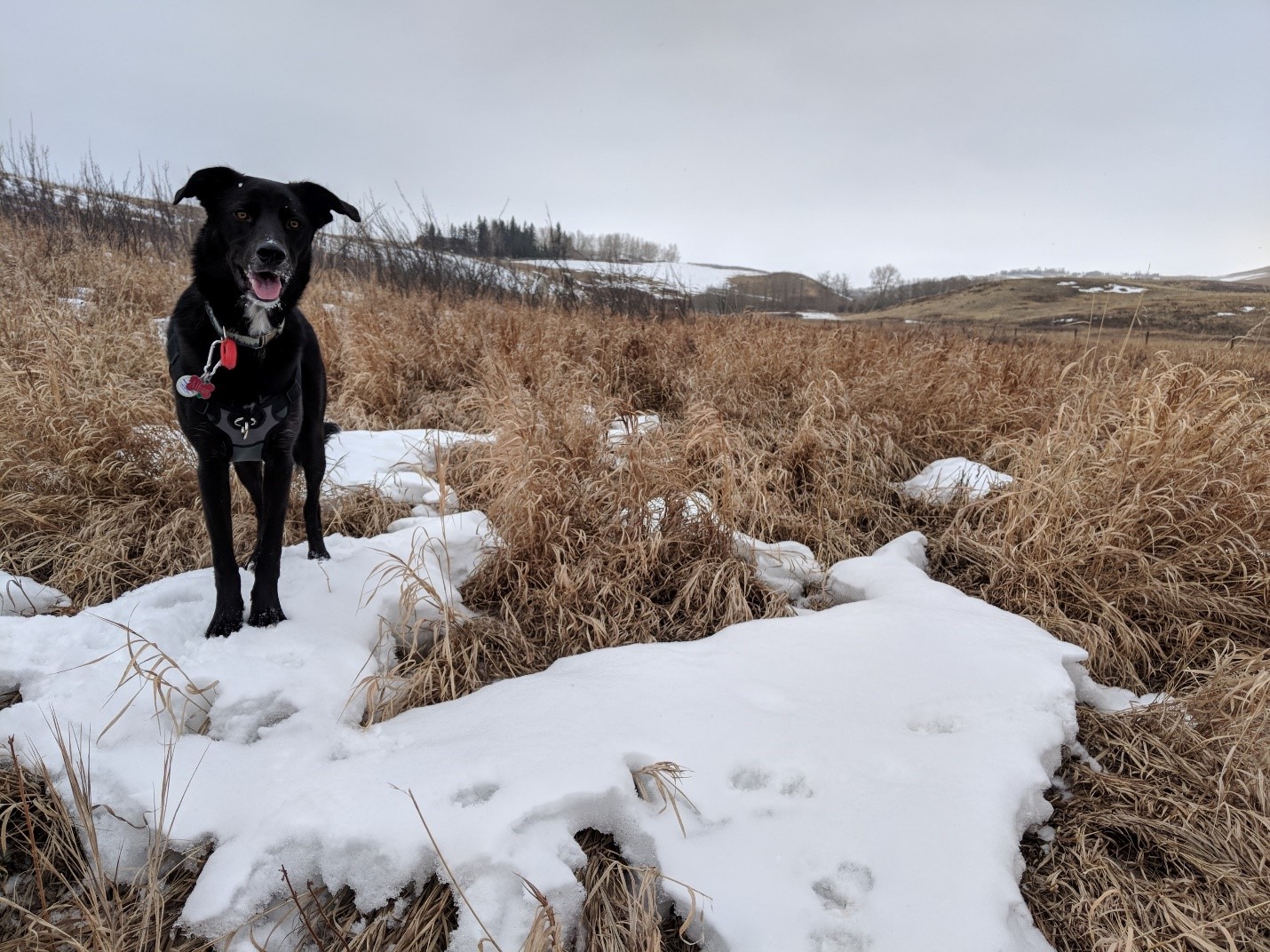
For the past few years, I have committed, heart, body and soul to the pursuit of my graduate degree in archaeology. I know many people in pursuit of their degrees would choose to study a fascinating subject, with the potential to change the world; but being the go-getter that I am, I chose the blood-racing world of dental microwear analysis. My focus, specifically, was in applying the study of dental microwear to bison from sites in southern Alberta to determine which seasons those sites were occupied (the site’s seasonality).
Albus, helping me observe the seasonal trends in grass growth on one of my regular visits to Glenbow Ranch Provincial Park.
What is dental microwear?
The analysis of microscopic patterns on teeth has been useful to several fields, including archaeology. The method can provide information about an animal’s diet immediately before death, allowing researchers to reconstruct past environments and determine the season that an animal died. This is based on the recognition that different types of food produce identifiable features on the enamel of teeth.
In faunal archaeology, the most common distinctions made based on microwear are between herbivores who either graze or browse. Grazing animals that mainly eat grasses and other low-lying plants, such as cattle, tend to use a grinding motion when chewing, which drags food across the enamel. This produces features Read more →
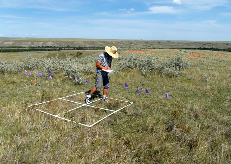
Field assistant mapping a medicine wheel. Purple and green flags mark spokes, orange flags mark cobble rings.
Often, archaeological discoveries are thought to only result from physical archaeological surveys. However, later data analysis and computer modeling can also provide important insights not easily seen in the field. Recent efforts to reconstruct possible past travel routes along the Red Deer River north of Brooks help illustrate just such a situation. Exciting archaeological finds were made, both through traditional archaeological survey techniques in the field, as well as with modern computer modelling approaches later in the office. These finds highlight the importance of viewing the past not simply as a series of isolated archaeological sites, but rather as a continuous cultural landscape.
Two seasons of fieldwork, consisting of more than 400 km of pedestrian survey, were conducted along the edges of the Red Deer River valley for some 43.5 km of the river’s course. The area was situated in some of the warmest and driest parts of the province, with vegetation consisting primarily of grasses, a few shrubs and vast swaths of prickly pear cactus. While some portions were virtually devoid of vegetation, unusually high amounts of precipitation throughout the region had encouraged thick grass growth in most other areas, and had kept the prairie a rich green colour for much longer than usual. Hidden within that thick cover of grass were large numbers of archaeological cobble features – the location of close to 1,000 of which were recorded with GPS. Unsurprisingly, the vast majority of features recorded during the fieldwork were standard cobble rings that marked the locations of past tipis. Also recorded, however, were significant numbers of other types of cobble structures, like standard cobble cairns and cobble arcs, as well as more unusual features , like tailed cobble rings, hollow cairns, and medicine wheels.
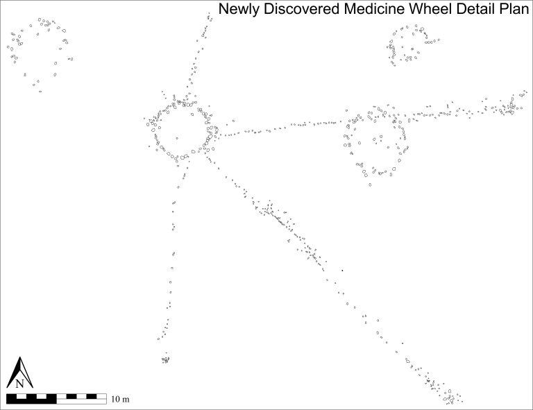
Southern Alberta is home to a greater number of medicine wheels than any other jurisdiction, and the Red Deer River appears to be a particularly rich location for them. Image provided by Terry Beaulieu.
A total of five known medicine wheels were located in the area. Due to land access issues, however, only two of the five were visited during the present investigation. One new medicine wheel, though, was discovered. Like the other five medicine wheels in the vicinity, the newly discovered medicine wheel lies quite close to the valley edge, overlooking the Red Deer River to the east. It has a very well defined 5.25 m diameter central cobble ring from which four less-well defined linear cobble spokes radiate. The three longest spokes each terminate at a cobble cairn. A cobble ring is bisected along its northern edge approximately midway along the east northeast running spoke and a tailed cobble ring, along with a standard cobble ring, lie close by.
The wealth of locational data collected for the recorded cobble features was critical to computer analyses later conducted in the office. Close to 1,000 data points – the locations of archaeological cobble features – were imported into a geographic information system (GIS) to form the basis of a sophisticated spatial modeling analysis. Archaeological applications of GIS have often been criticized for placing too much emphasis on the physical environment and of therefore being guilty of excessive environmental determinism. The modelling approach taken in this study was designed to intentionally emphasize cultural elements in order to address such concerns with what is generally considered to be a landscape archaeological approach.
One of the ways cultural elements were emphasized was through identifying and integrating the concept of place into the GIS analysis. Incorporating locations into the GIS that had been identified based on place names known to have been used by Indigenous people was one such method employed. Past places were also determined by using the archaeological information collected in the field. Locations indicative of important places, for example, were identified by locating significant concentrations of standard cobble rings, or finding the presence of known ceremonial features such as medicine wheels and hollow cairns, among others. GIS modelling was then conducted in an effort to locate and model pedestrian travel routes that may have been employed by past people during their summer travels through the region when heading to the nearby important location of Hunting Hill.
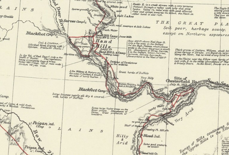
A segment of Palliser’s 1865 map showing the route he travelled (marked in red) down Bullpound Creek and across the Red Deer River when visiting a Blackfoot Camp. Provided by Terry Beaulieu.
The GIS models indicated a crossing point located near where Bull Pound Creek empties into the Red Deer River. The problem, however, was that most early maps of the area indicated the closest known river crossing was upstream from there at Lord Lorne Crossing. It therefore appeared the GIS models were flawed. Further investigation, however, revealed that was likely not the case.
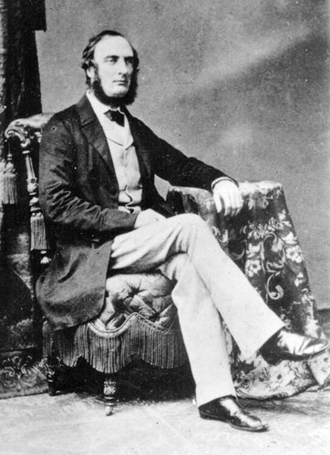
In the summer of 1859, Captain John Palliser travelled through the region as part of his multi-year expedition through western Canada. He was one of the first Europeans to visit the region and the maps he produced are some of the earliest created of the area. During those travels he wrote of visiting “Blackfoot Indian” camps. The route he travelled during one of those visits ran down the east side of Bull Pound Creek and crossed the Red Deer River at the point where the creek emptied into the river – at almost the exact location indicated by the GIS models. Given that Palliser was likely being guided by residents of the camp, who would have been familiar with the best routes and river crossings, the concurrence between Palliser’s map and the GIS models indicates the modelling process was indeed successful in identifying the location of a river crossing point used by past peoples.
Captain John Palliser was one of the first Europeans to visit western Canada and the maps he produced are some of the earliest created of the area. Source: Wiki Commons
It is interesting to note that less than a quarter century later, when George M. Dawson, of the Geological Survey of Canada, created his maps of the area, the crossing near the mouth of Bullpound Creek was no longer recognized by those creating the maps. Lord Lorne Crossing, significantly upstream from the mouth of Bullpound Creek, had instead replaced it as the important crossing place. Such a shift illustrates how quickly changes occurred on the prairies in the mid to late 1800s, and how fast Indigenous information became lost and undervalued during European map making. Information about the locations of significant places to past people does not have to remain lost and forgotten, though, and can be resurrected through thorough investigation and careful research, as is evident by the discovery of a previously unknown medicine wheel and the identification of a forgotten river crossing. Both are significant additions to the archaeological record that, in addition to helping inform our understanding of the past, also show that important new archaeological discoveries are still being made, whether through old fashioned archaeological legwork or modern computer analysis.
Written by: Terry Beaulieu, Ph.D. Graduate, University of Calgary
Thank you to guest authors, Margaret Patton and Shalcey Dowkes, for this interesting post about shell beads from a unique archaeological site in Southern Alberta.
The authors would like to acknowledge the Siksika Nation and Blackfoot Crossing Historical Park in their support for the ongoing archaeological research at Cluny Fortified Village.
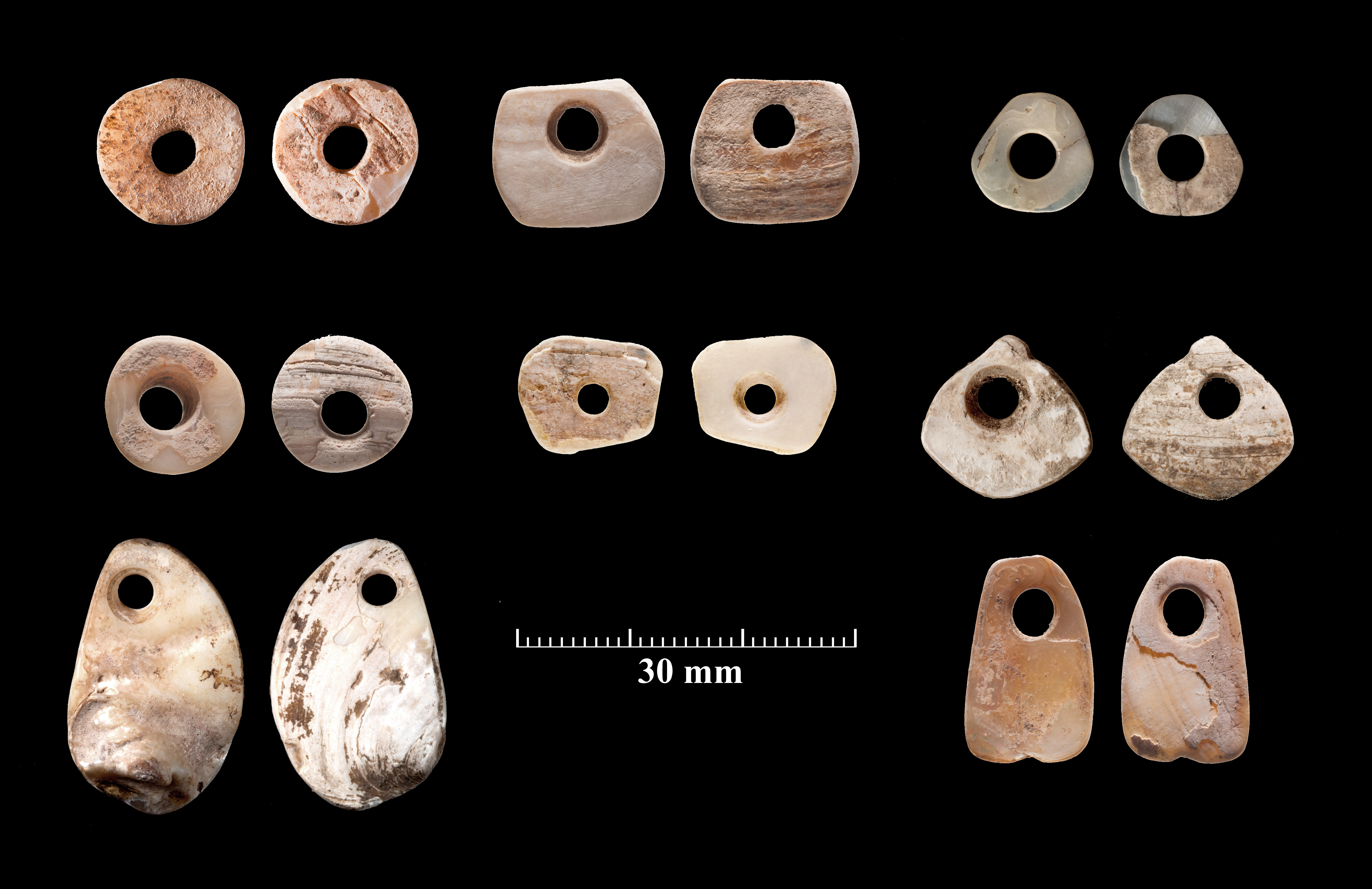
Most beads from Cluny Fortified village are disc beads (upper left), but a variety of other shapes have also been found. For each pair of beads, the left image is the inside shell surface and the right image is the outside shell surface.
All over the world beads have been manufactured for adornment in jewelry and clothing, trade, and may have even been used in storytelling and gaming. In North America, Indigenous groups in extensively traded marine shells. On the Plains, freshwater clams from local rivers were also used to manufacture beads. However, there are limited examples of freshwater shell beads found archaeologically on the Northern Plains. Over 1,450 pieces of shell have been recovered from the Cluny Fortified Village archaeological site, making it a prime candidate to study the production of beads on the Canadian Plains.
Cluny Fortified Village
The Cluny Fortified Village Site is unique as the only known fortified village on the Northern Plains. Located on the northern bank of the Bow River, the site Read more →
The Book Publishers Association of Alberta (BPAA) held their annual Alberta Book Publishing Awards on September 14 in Calgary. These awards recognize and celebrate the best of the Alberta book publishing industry. Of special note for the Historic Resources Management Branch is that Alberta’s Lower Athabasca Basin: Archaeology and Palaeoenvironments was awarded the Scholarly and Academic Book of the Year. This book was a collaborative effort between current and former employees of the Historic Resources Management Branch and the Royal Alberta Museum, researchers at the University of Alberta, members of Alberta’s archaeological consulting community, and Athabasca University Press. Well done and congratulations to everyone involved!
This volume tells a fascinating story of the oil sands region of northeastern Alberta, including how a catastrophic flood at the end of the last ice age formed the landscape of the region. It also highlights the intensive use of resources in the area by precontact groups since ca. 11,000 years ago. When the flood went through, it scoured pre-existing glacial deposits, and made bedrock deposits such as bitumen and a lithic raw material called Beaver River Sandstone accessible from the surface. Beaver River Sandstone was used to make stone tools for millennia following the flood. This stone can be found at a site called Quarry of the Ancestors near Fort McMurray, and over two million artifacts made of this material has been recorded in Alberta’s archaeological record. The chapters in this volume are invaluable for understanding the ecological and human past in northeastern Alberta and are important for informing future management of historic resources in the region.
Alberta’s Lower Athabasca Basin: Archaeology and Palaeoenvironments can be purchased or downloaded for free through Athabasca University Press.
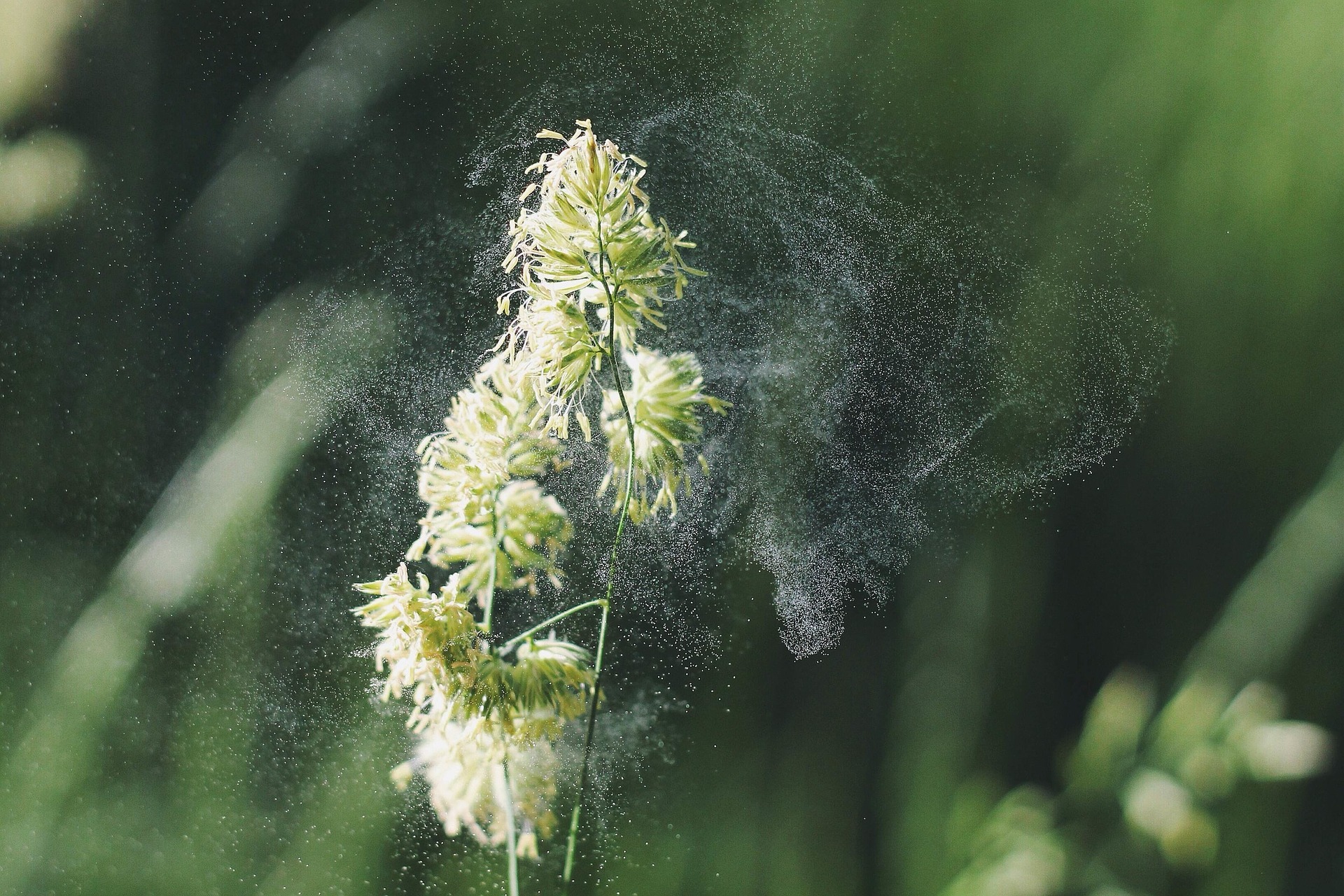
Anyone with allergies knows when spring begins, and plants start pollinating, the offensive ‘dust’ can wreak havoc. However, one of the great things with pollen, from an archaeological perspective, is the fact that it gets dispersed annually. This means that each year, the ‘signature’ of the pollen released tells us about the landscape at the time. Plants have evolved to reproduce with pollen in several ways, and one that is highly effective is pollinating via the wind.
Pollen being released from a flower which will be carried by the wind. Plant Pollen is available through the CC0 Public Domain.
When the wind transports pollen it gets dispersed across the landscape, sometimes even getting caught within puddles. Inevitably, many pollen grains get caught in lakes and accumulate in the sediments. When it settles on the bottom of a lake basin, it stays there and is preserved for researchers to find hundreds, and even thousands, of years later. All this Read more →
“The antelope possesses an unconquerable inquisitiveness, of which hunters often take advantage…The hunter, getting as near the animal as is practicable, conceals himself by lying down, then fixing a handkerchief or cap upon the end of his ramrod, continues to wave it, remaining concealed. The animal, after a long contest between curiosity and fear, at length approaches near enough to become a sacrifice to the former.” (James 1905, vol. 2, pp. 227)
On two different flights over southeastern Alberta, separated by about thirty years, unusual stone features were observed on the landscape. Upon further inspection by archaeologists, it was determined that these two sites are the remnants of drive lanes and traps that were used for the communal hunting of pronghorn (Antilocapra americana, also commonly referred to as antelope).
While it is commonly known that bison were one of the greatest resources for precontact North American Indigenous groups, it is important to note that before European arrival, it is thought that there were just as many pronghorn as bison in North America. They were an important resource as well, particularly for people living in the Great Basin region of the United States, as pronghorn were one of the largest game animals available in that region. For Plains groups, bison were preferred for meat (and there is abundant archaeological evidence of this in the many bison kill sites across the Plains), however, pronghorn were valued for their hides to make clothing and other items.
Pronghorn or Antilocapra Americana, also commonly referred to as antelope. Photo courtesy of Royal Alberta Museum.
Pronghorn or Antilocapra Americana, also commonly referred to as antelope. Photo courtesy of Royal Alberta Museum.
Communal antelope hunting is documented in many historical accounts both in the Great Basin and on the Plains. These accounts describe wood and brush drive lines that led to fenced enclosures and to pit traps excavated in the ground. Hunters disguised themselves as antelope, wolf or other animals to get close to the herds and then drove the animals into Read more →
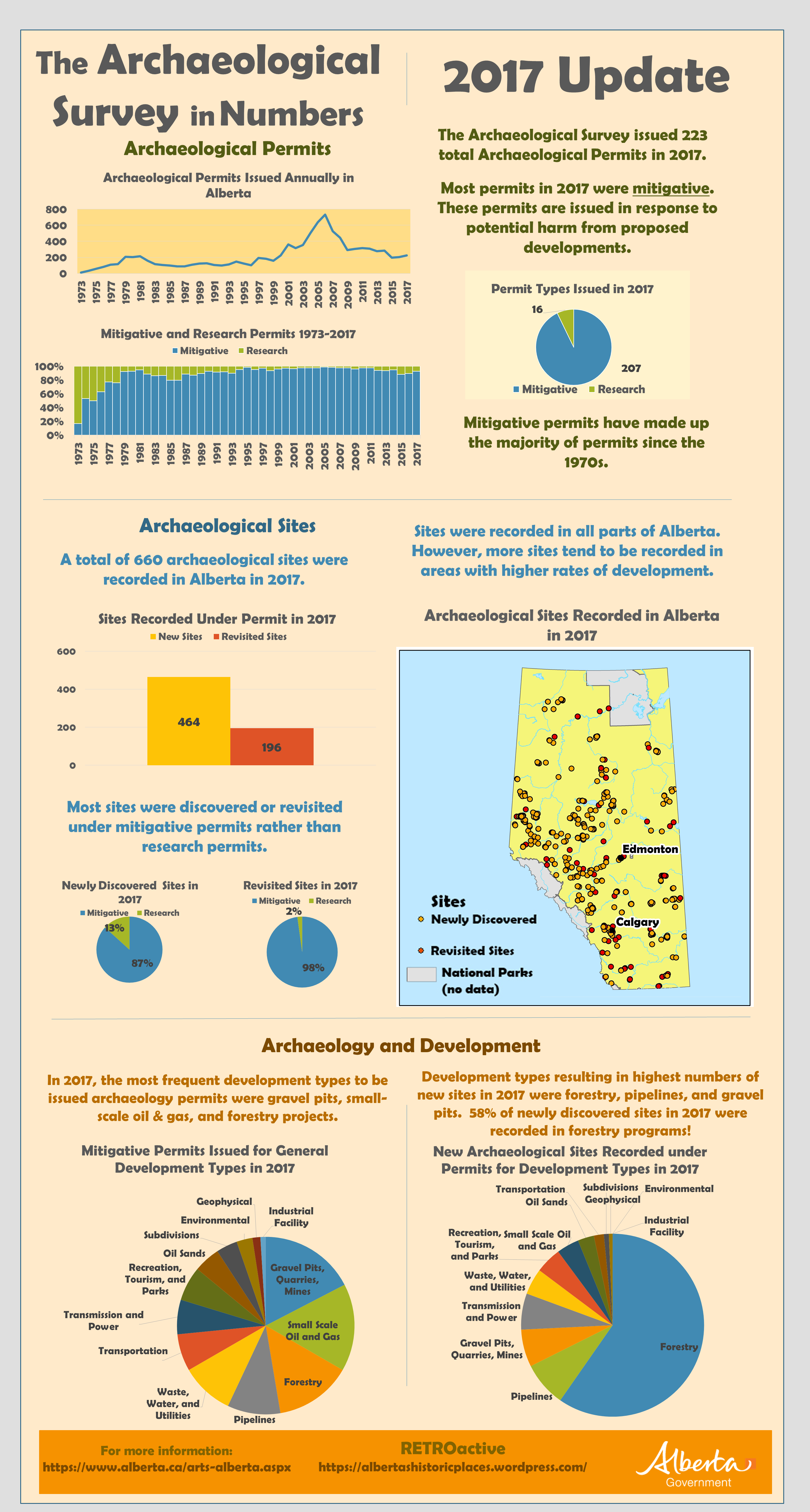
This week’s post is an update on archaeological project and site data for 2017 from the Archaeological Survey. Click the image below and zoom to see the full size infographic.
Note on archaeological sites: the site counts for 2017 are not yet final. They are constantly being updated as consultants and researchers submit their records to the Archaeological Survey. Stay tuned to RETROactive for up-to-date numbers.
Whether excavating archaeological sites or surveying the land in search of undiscovered ones, archaeologists create data. That data can take the form of field journals, artifact catalogues, GPS tracks and waypoints, photographs, excavation plans, level records, site forms, and reports. It is often said that for every month spent in the field, an archaeologist will spend a year in the lab and the office processing the field data they collected.
The Archaeological Survey (the Survey) began managing Alberta archaeological sites, research, and mitigation in 1972, with the passing of what is now known as the Historical Resources Act. At the same time, the Survey also became the official provincial repository for most archaeological data. Today the Survey collects and archives data for use by archaeological researchers, consultants, and other stakeholders, and also relies on archaeological data in order to run the historic resources management machinery. Read more →