Written by: Ron Kelland, Historic Places Research and Designation Program
Place names are an integral part of cultural heritage. In recognition of National Indigenous Peoples Day, the Geographical names Board of Canada has released a dataset of Indigenous place names. The dataset contains about 20,000 names confirmed or reasonably believed to be of Indigenous origin, First Nations, Inuit or Métis. The names have been pulled from the Canadian Geographical Names Database, which is populated with toponymic information from the provincial and territorial naming authorities.
The dataset can be viewed online and is also available with other accompanying documentation from the Government of Canada’s Open Government portal. It can be downloaded in CSV, KML and SHP formats as well as a Web Map Service. Toponomy is an ever changing field with new names being adopted and new knowledge of existing names being discovered. Moving forward, the dataset will be updated weekly to capture these additions and changes. The dataset is freely accessible, but is subject to the Government of Canada’s Open Government License.
Screenshot of the Indigenous Place Names Dataset web viewer. Source: Natural Resources Canada, 2022.
Written by: Ron Kelland, Geographical Names Program Coordinator
At an online event on March 8, 2020, Seamus O’Regan, the Minister of Natural Resources Canada launched Recognizing Women with Canadian Place Names: Women on the Canadian Landscape. This interactive, digital map was developed by the Geographical names Board of Canada to highlight approximately 500 places and geographical features in Canada that are named for women.
Screenshot of the “Recognizing Women with Canadian Place Names” Interactive map. Source: Natural Resources Canada.
March 8 was International Women’s Day; a day acknowledged around the world to raise awareness of issues facing women, such as gender equity, and to celebrate the social, cultural and political achievements that have been made by women to their communities, regions and nations. The map was launched on that day as part of those annual celebrations.
Through history, the recognition of women has tended to be forgotten. For generations, women have been largely voiceless in history; overlooked by default and design. The essential domestic role of settler women has not been discussed to the same extent as the work of their husbands, fathers and brothers breaking the land, even though these women toiled and suffered just as men had. Even women who were admitted to the professional, scientific or professional world have often seen their accomplishments ignored or downplayed in favour of those of their male colleagues. The same trends are found in the world of cartography and place naming.
How can Santa Claus see all of this? How can he know what we are doing all of the time? Where exactly does he get his information? While some more imaginative people believe that Santa Claus must have magical, all-knowing, all-seeing powers. Other, more practical-minded folk, insist that he must have a vast network of elfin spies keeping tabs on every boy and girl in his domain. However, here in Alberta we know better. Santa Claus obviously does his recon from his lofty vantage point in the Canadian Rockies from which he can see great distances – perhaps even into your own home (and isn’t that just a little bit creepy?). Read more →
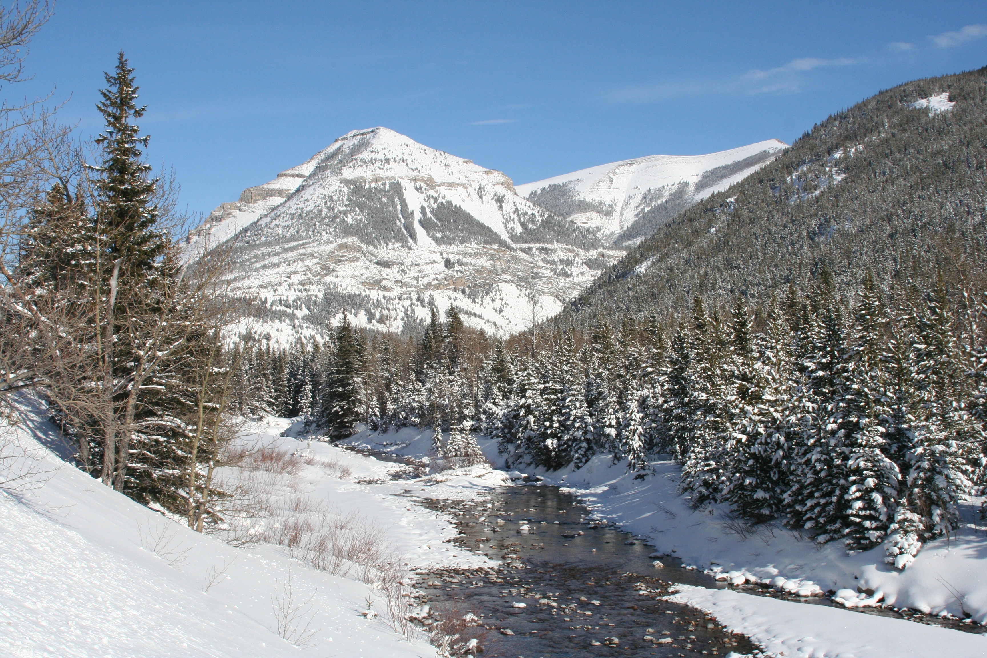
No single event has had such a dramatic impact on place names in Alberta than the First World War Battle of Jutland. Deep in the heart of Kananaskis Country can be found a series of mountains bearing the names of the ships and naval commanders of this naval battle. At least twenty-six mountains bear names commemorating the Battle of Jutland – sixteen of them are named for Royal Navy vessels that took part in the battle and ten are named for the Admirals, ship captains and seamen that lead and fought at Jutland. Additionally, many features associated with the mountains (glaciers, lakes and creeks) have subsequently been given Jutland names. The great number of Jutland-related geographical names in Alberta is curious. While there is no questioning the significance of the Battle of Jutland – it was the only major sea battle of the First World War, one of the few times in which dreadnought battleships fought directly against each other and its results affected strategy and tactics on both sides and altered the course of the war – it was also a battle in which there was no significant Canadian presence; no Canadian ships were involved and only one Canadian casualty has ever been confirmed. So, how did so many of these mountains along the Alberta-British Columbia boundary end up being named to commemorate this battle?
Mount Engadine (left), The Tower (middle) and Mount Galatea (right), taken in 1916 by the Interprovincial Boundary Survey. Mount Engadine and Mount Galatea are named for Royal Navy vessels that fought at the Battle of Jutland, the seaplane carrier HMS Engadine and the light cruiser HMS Galatea. Image Source: Mountain Legacy Project, IMG_3320. The Mountain Legacy Project is based at the School of Environmental Studies, University of Victoria, Victoria, BC. For more information, go to mountainlegacy.ca, or email mntnlgcy@uvic.ca.
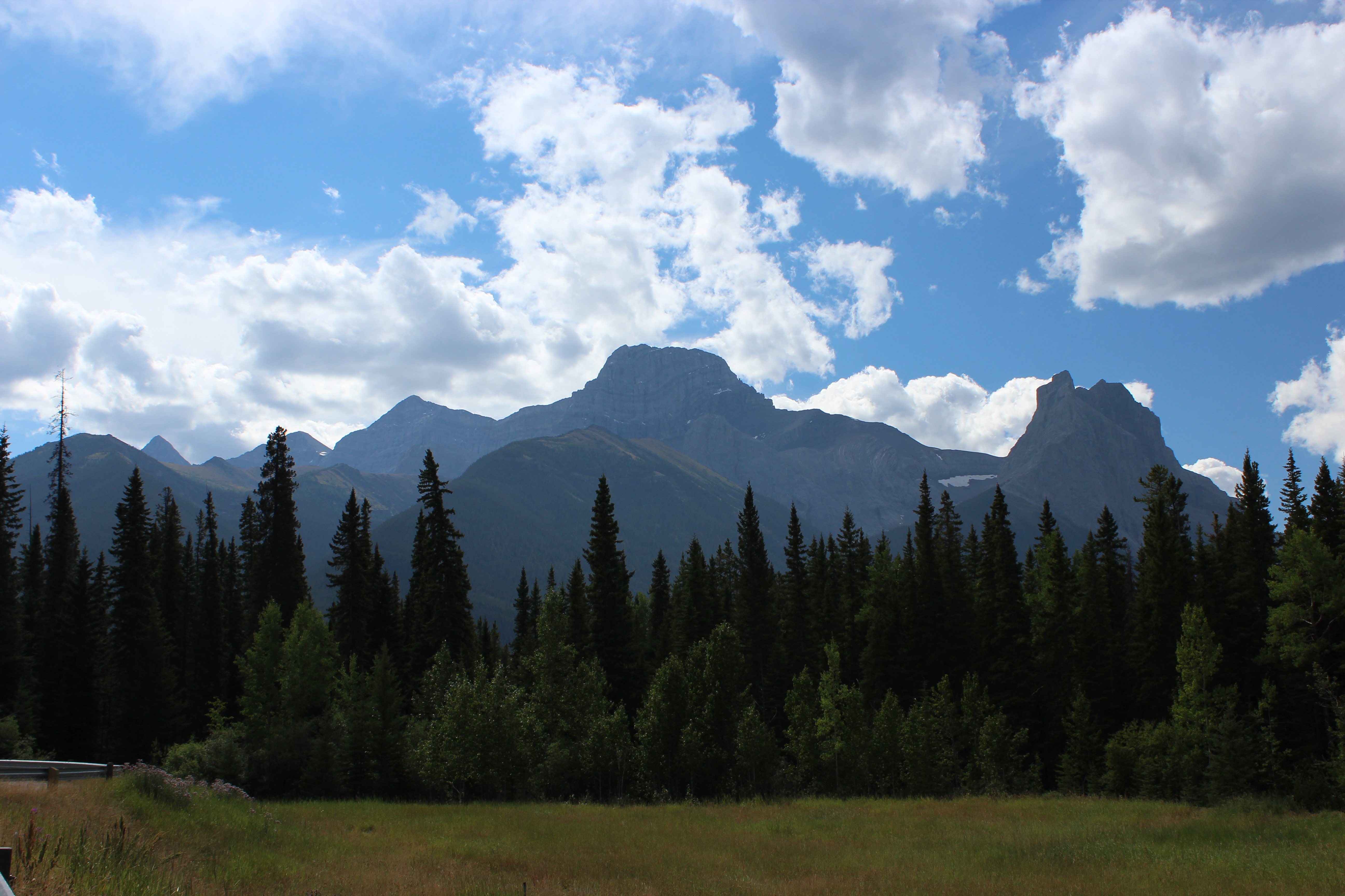
One of the most recognizable mountains in the Canadian Rockies is Mount Lougheed. Located approximately 15 kilometres southeast of Canmore, this majestic 3,150 metre (10,335 ft.) mountain is named for Sir James Alexander Lougheed. However, Lougheed is not the only name the mountain has had. In fact, it is not even the first mountain in the area to bear the name Lougheed. The story of how the mountain became known as Mount Lougheed is interesting.
Mount Lougheed from the Trans-Canada Highway, August 2011. The entire massif is known as Mount Lougheed. The large, central peak is likely the feature named “Windy Mountain” by Eugene Bourgeau in 1858. The prominent peak furthest to the right is Windtower Mountain. The peak known today as Wind Mountain is the distinctly pointed peak visible on the horizon at left side of the photograph. Source: Larry Pearson, Historic Places Stewardship Section, Alberta Culture and Tourism.
In 1858, Eugène Bourgeau (sometimes spelled Bourgeaux), a botanist with the Palliser Expedition, accompanied James Hector up the Bow Valley towards what is now Canmore. Bourgeau named many of the mountains and lakes along the way. Bourgeau was struck by the way the clouds swirled around one particular peak. James Hector, in his account of August 11, 1858, noted that Read more →
Located between the Astoria and the Whirlpool rivers is a mountain considered by many to be the most majestic in Jasper National Park, if not the entire Canadian Rocky Mountains. At an impressive altitude of about 3,300 metres, the mountain has been known by a number of names. French Canadian voyageurs using the Athabasca Pass referred to the notable landmark as La Montagne de la Grand Traverse (Mountain of the Great Pass). Dr. James Hector of the Palliser Expedition referred to it as Le Duc, probably after a Metis member of his party. In 1912, Arthur O. Wheeler of the Alpine Club of Canada and the Interprovincial Boundary Survey named it Fitzhugh Mountain, after the townsite of Fitzhugh, which was named for E. L. Fitzhugh, a director of the Grand Trunk Pacific Railway (the townsite of Fitzhugh was later renamed Jasper). It had also been periodically, and incorrectly, referred to as Mount Geikie. Today, and since 1916, the mountain is named Mount Edith Cavell, named for a British nurse who never set foot in Canada, let alone within Jasper National Park or on the mountain itself. How this mountain became a commemoration to Edith Cavell is an interesting lesson in Canada’s role in the First World War, its place in the Empire and the importance of wartime symbolism and the values of myth and memorialization.
North face of Mount Edith Cavell with Lake Cavell in the foreground, ca. 1945. Provincial Archives of Alberta, PA354.1
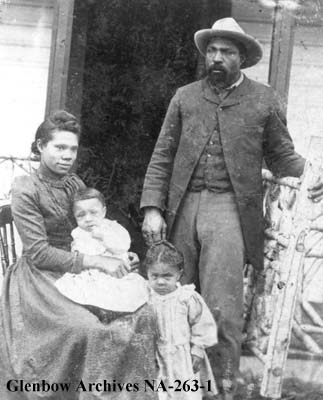
Alberta’s history is rife with many stories of interesting and fascinating cowboys and ranchers. High in this company stands John Ware, a black cowboy and rancher of near-mythic standing in Alberta’s history. John Ware has become almost an unofficial emblem of Alberta and western Canada, featuring prominently in centennial exhibits, in books and even on a Canada Post stamp. He is often portrayed as an embodiment of western Canadian values and as a demonstration of the levelling effect of the pioneer period and the cultural tolerance that was only possible on the Canadian prairies. There is little doubt that John Ware truly did enjoy the respect of his fellow ranchers and cowboys and his story, even if exaggerated, is an inspiring one. Yet, despite this outpouring of goodwill, respect and admiration, for many years John Ware was commemorated by a racially derogatory name prominently displayed on maps.
John Ware with his wife Mildred and two of their children, Robert and Nettie, ca. 1896. Glenbow Archives: NA-263-1
In a previous post, we looked at the naming of five mountains in Jasper National Park after First World War Victoria Cross recipients. It took a number of years and some persistence from the Geographic Board of Alberta to achieve this natural war monument for the service of five soldiers to the British Commonwealth in the First World War. In addition to naming the mountains, the negotiations between provincial and federal naming authorities resulted in the naming of the Victoria Cross Ranges in Jasper National Park to serve as a long-standing tribute to all recipients of the Victoria Cross. This naming decision created a naming policy that is still honoured today.
Looking west to the Victoria Cross Ranges (Image courtesy of Mountain Nerd on Summit Search)
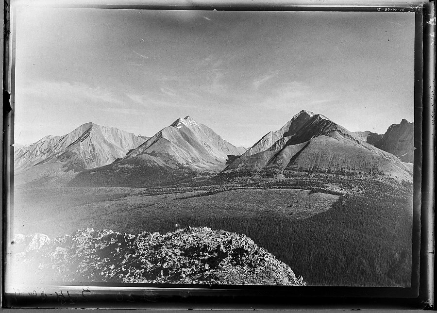
In 1917, surveyor and mountaineer Arthur O. Wheeler of the Interprovincial Boundary Survey wrote that “in a valley surrounded by towering peaks, lies Upper Kananaskis Lake, a large sheet of deep-blue water of irregular shape, dotted with heavily-timbered islands.” The lake, as described by Wheeler, no longer exists, its shape has changed and its islands are mostly gone.
Upper Kananaskis Lake, 1914, showing the islands (LtoR) Cressy, Pegasus, Hawke, Hogue, Schooner and Aboukir. To compare this photograph alongside a 2007 photograph, go to http://explore.mountainlegacy.ca/historic_captures/1880/comparisons. Mountain Legacy Project, WHE14-6. The Mountain Legacy Project is based at the School of Environmental Studies, University of Victoria, Victoria, BC. For more information, go to mountainlegacy.ca, or email mntnlgcy@uvic.ca.
Most people understand the importance of the oil discovered at Leduc in 1947 and the oil and gas discovered in Turner Valley in 1914. However, Alberta’s oil and gas industry began in 1901 with an isolated oil well alongside a creek near the Canada-United States border.
That creek was known as Oil Creek. Now known as Cameron Creek, this 15 kilometre long creek runs north-easterly for about 9 kilometres before turning and flowing south-easterly into Upper Waterton Lake. The source of the creek is Cameron Lake, a small lake on the Canada-U.S. border deep within Waterton Lakes National Park. The lake was once known as Oil Lake. (Do you see a pattern?)
Aerial Imagery of Waterton Lakes National Park, showing the locations of the Cameron Lake (formerly Oil Lake) Cameron Creek (formerly Oil Creek) and the First Oil Well in Western Canada National Historic Site of Canada.
The lake and the creek were noted, but not named, on George Dawson’s 1884 map of the Bow and Belly River region of the North-West Territories. During his surveys of the area in the 1880s (with the Geological Survey of Canada) and earlier (with the International Boundary Commission) in the 1870s, Dawson was made aware of oil and gas in the Waterton region. In 1901, the Rocky Mountain Development Company drilled Western Canada’s first oil well alongside a creek, which soon became known, for obvious reasons, as Oil Creek.
In 1915, during the survey of the Alberta-British Columbia border, the lake and creek were again noted. The 1917 report on the Alberta- B.C. boundary described them as: “Cameron Lake, a picturesque sheet of water, one mile and a half long by half a mile wide” and “Cameron Brook, a stream of considerable size, which flows to Upper Waterton Lake”.
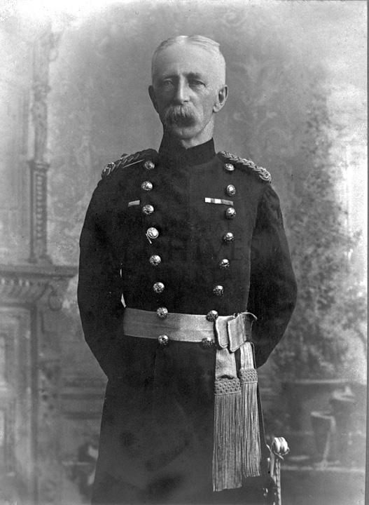
The lake and creek were named for Maj.-Gen. Donald Roderick Cameron, a Scottish-born Royal Artillery officer and son-in-law to Sir Charles Tupper. Prime Minister John A. Macdonald recommended Cameron’s appointment as the British Boundary Commissioner and head of the British-Canadian delegation to the International Boundary Commission. From 1872-76, Cameron oversaw the surveying of the Canada-U.S. border between the Lake of the Woods (in western Ontario) to the Rocky Mountains. He later represented Canada on numerous international commissions and conferences through the 1880s and he served as commandant of the Royal Military College in Kingston, Ontario from 1888 to 1896. For his services to the boundary commission he was appointed to the Order of St. Michael and St. George by Queen Victoria. General Cameron died in 1921. In 1943, Cameron Falls, just north of the Waterton Park town site, was also named in his honour.
Capt. Donald R. Cameron, head of the British-Canadian contingent of the International Boundary Survey, in 1872.
In 1915, the Geographic Board of Canada adopted Cameron Brook as the official name for the creek. Although, the name of the lake was not officially changed at the time, it nevertheless began appearing on federal government maps as Cameron Lake. The name Cameron Lake was officially adopted in 1928. The following year, the United States Board on Geographic Names adopted the same name for the portion of the lake located in Montana. In 1960, the Canadian Board on Geographical Names renamed Cameron Brook as Cameron Creek.
Cameron Creek, formerly known as Oil Creek, flows through the rugged terrain of Waterton Lakes National Park. Western Canada’s first oil well was located alongside this creek.
Although the names Oil Lake and Oil Creek are no longer official, the significance of the area in the development of Canada’s oil sector is commemorated by the Historic Sites and Monuments Board of Canada. In 1965, a monument was erected at the site the original oil well and the site was named the First Oil Well in Western Canada National Historic Site of Canada.
Written by: Ron Kelland, Historic Places Research Officer and Geographical Names Program Coordinator.
Location
Cameron Creek
National Topographic System Map Sheet: 82 H/04 – Waterton Lakes
Latitude/Longitude: 49°01’11N / 114°02’38”W to 49°02’41”N / 113°54’45”W
Alberta Township System: SW11-01-01-W5 to NW14-01-30-W4
Description: Flows into Upper Waterton Lake within the Waterton Park town site.
Cameron Lake
National Topographic System Map Sheet: 82 G/01 – Sage Creek
Alberta Township System: 2, 3, 10, 11-01-01-W5
Description: On the Canada/US border approximately 11 km south west of the Waterton Park town site and 1 km east of the Alberta/British Columbia boundary.
Additional Resources
More information about Cameron Creek, Cameron Lake, Maj-Gen. Donald R. Cameron and the First Oil Well in Western Canada can be found in:
Edwards, Victoria. “Major General Donald Roderick Cameron C.M.G.” eVeritas [electronic newsletter of the Royal Military College Club], available from http://everitas.rmcclub.ca/?p=4485. (Accessed 16 Oct 2013).
Rees, Tony. Arc of the Medicine Line: mapping the World’s Longest Undefended Border across the Western Plains. Lincoln, NB: University of Nebraska Press, 2007.