Written by: Ron Kelland, Historic Places Research Officer
Back a few weeks ago, in the early days of COVID-19 pandemic response, I, like many Albertans, was closely watching news coverage. One news story that caught my attention was about the lines of traffic of returning Canadian travelers at the Coutts/Sweet Grass International Border Crossing. The story really jumped out at me because I had just read about novelist Charles Dickens’ involvement with the philanthropic work of Baroness Angela Burdett-Coutts. Being the geographical names guy, I was aware that the village of Coutts and the hamlet of Burdett were named for the Baroness Burdett-Coutts, so I started to think about how was it that these two communities ended up with names honouring and commemorating a Victorian-Age, aristocratic philanthropist and social reformer.
Baroness Burdett-Coutts, artist unknown, oil on panel, ca. 1840. Source: National Portrait Gallery, London, NPG 6181. Used under Creative Commons License (CC BY-NC-ND 3.0)
Angela Burdett-Coutts, the 1st Baroness Burdett-Coutts was born Angela Burdett in 1814, the daughter of radical reformist politician and anti-slavery advocate Sir Francis Burdett and Sophia Burdett (née Coutts). In 1837, upon the death of her step-grandmother, the actress Harriet Mellon, Angela inherited the entire Coutts estate of £1.8 million ($191 million in 2020 Canadian dollars) including a substantial interest in the Coutts Bank, making her the second-wealthiest woman in the United Kingdom after Queen Victoria. In accordance with the conditions of the will, Angela Burdett sought and received royal license to combine her ancestral names to become Angela Burdett-Coutts.
Written by: Ken Favrholdt, BA, MA (Geography, UBC)
Much is written about the Whoop-Up Trail, the famous 320 kilometre route from Fort Benton, Montana to Fort Macleod used by whisky traders between 1869 and 1874.
However, there was also another important route used during this period. The Riplinger Trail was an Indigenous trail across traditional Blackfoot territory and home of the Blood tribe. Part of the trail in Montana it is believed, was part of the Old North Trail, the ancient migration route—the so-called ice-free corridor—along the Front Range of the Rocky Mountains. The Riplinger Trail was named after John Riplinger of the Northwestern Fur Company who built a post on the Marias River in Montana in 1869-70.
Part of the geological map of the region in the vicinity of the Bow and Belly Rivers, by George Dawson, 1884, showing the Riplinger Trail between Fort Macleod and the 49th parallel. Source: collections.leventhalmap.org.
How can Santa Claus see all of this? How can he know what we are doing all of the time? Where exactly does he get his information? While some more imaginative people believe that Santa Claus must have magical, all-knowing, all-seeing powers. Other, more practical-minded folk, insist that he must have a vast network of elfin spies keeping tabs on every boy and girl in his domain. However, here in Alberta we know better. Santa Claus obviously does his recon from his lofty vantage point in the Canadian Rockies from which he can see great distances – perhaps even into your own home (and isn’t that just a little bit creepy?). Read more →
No single event has had such a dramatic impact on place names in Alberta than the First World War Battle of Jutland. Deep in the heart of Kananaskis Country can be found a series of mountains bearing the names of the ships and naval commanders of this naval battle. At least twenty-six mountains bear names commemorating the Battle of Jutland – sixteen of them are named for Royal Navy vessels that took part in the battle and ten are named for the Admirals, ship captains and seamen that lead and fought at Jutland. Additionally, many features associated with the mountains (glaciers, lakes and creeks) have subsequently been given Jutland names. The great number of Jutland-related geographical names in Alberta is curious. While there is no questioning the significance of the Battle of Jutland – it was the only major sea battle of the First World War, one of the few times in which dreadnought battleships fought directly against each other and its results affected strategy and tactics on both sides and altered the course of the war – it was also a battle in which there was no significant Canadian presence; no Canadian ships were involved and only one Canadian casualty has ever been confirmed. So, how did so many of these mountains along the Alberta-British Columbia boundary end up being named to commemorate this battle?
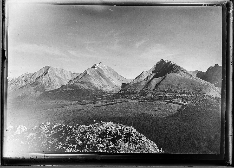
Mount Engadine (left), The Tower (middle) and Mount Galatea (right), taken in 1916 by the Interprovincial Boundary Survey. Mount Engadine and Mount Galatea are named for Royal Navy vessels that fought at the Battle of Jutland, the seaplane carrier HMS Engadine and the light cruiser HMS Galatea. Image Source: Mountain Legacy Project, IMG_3320. The Mountain Legacy Project is based at the School of Environmental Studies, University of Victoria, Victoria, BC. For more information, go to mountainlegacy.ca, or email mntnlgcy@uvic.ca.
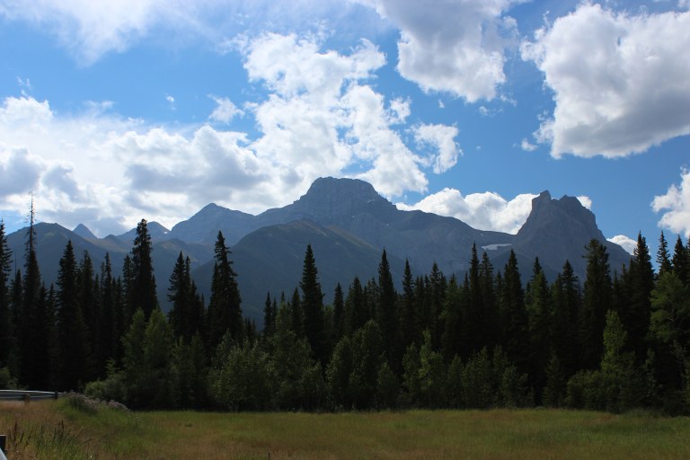
One of the most recognizable mountains in the Canadian Rockies is Mount Lougheed. Located approximately 15 kilometres southeast of Canmore, this majestic 3,150 metre (10,335 ft.) mountain is named for Sir James Alexander Lougheed. However, Lougheed is not the only name the mountain has had. In fact, it is not even the first mountain in the area to bear the name Lougheed. The story of how the mountain became known as Mount Lougheed is interesting.
Mount Lougheed from the Trans-Canada Highway, August 2011. The entire massif is known as Mount Lougheed. The large, central peak is likely the feature named “Windy Mountain” by Eugene Bourgeau in 1858. The prominent peak furthest to the right is Windtower Mountain. The peak known today as Wind Mountain is the distinctly pointed peak visible on the horizon at left side of the photograph. Source: Larry Pearson, Historic Places Stewardship Section, Alberta Culture and Tourism.
In 1858, Eugène Bourgeau (sometimes spelled Bourgeaux), a botanist with the Palliser Expedition, accompanied James Hector up the Bow Valley towards what is now Canmore. Bourgeau named many of the mountains and lakes along the way. Bourgeau was struck by the way the clouds swirled around one particular peak. James Hector, in his account of August 11, 1858, noted that Read more →
Located between the Astoria and the Whirlpool rivers is a mountain considered by many to be the most majestic in Jasper National Park, if not the entire Canadian Rocky Mountains. At an impressive altitude of about 3,300 metres, the mountain has been known by a number of names. French Canadian voyageurs using the Athabasca Pass referred to the notable landmark as La Montagne de la Grand Traverse (Mountain of the Great Pass). Dr. James Hector of the Palliser Expedition referred to it as Le Duc, probably after a Metis member of his party. In 1912, Arthur O. Wheeler of the Alpine Club of Canada and the Interprovincial Boundary Survey named it Fitzhugh Mountain, after the townsite of Fitzhugh, which was named for E. L. Fitzhugh, a director of the Grand Trunk Pacific Railway (the townsite of Fitzhugh was later renamed Jasper). It had also been periodically, and incorrectly, referred to as Mount Geikie. Today, and since 1916, the mountain is named Mount Edith Cavell, named for a British nurse who never set foot in Canada, let alone within Jasper National Park or on the mountain itself. How this mountain became a commemoration to Edith Cavell is an interesting lesson in Canada’s role in the First World War, its place in the Empire and the importance of wartime symbolism and the values of myth and memorialization.
North face of Mount Edith Cavell with Lake Cavell in the foreground, ca. 1945. Provincial Archives of Alberta, PA354.1
Alberta’s history is rife with many stories of interesting and fascinating cowboys and ranchers. High in this company stands John Ware, a black cowboy and rancher of near-mythic standing in Alberta’s history. John Ware has become almost an unofficial emblem of Alberta and western Canada, featuring prominently in centennial exhibits, in books and even on a Canada Post stamp. He is often portrayed as an embodiment of western Canadian values and as a demonstration of the levelling effect of the pioneer period and the cultural tolerance that was only possible on the Canadian prairies. There is little doubt that John Ware truly did enjoy the respect of his fellow ranchers and cowboys and his story, even if exaggerated, is an inspiring one. Yet, despite this outpouring of goodwill, respect and admiration, for many years John Ware was commemorated by a racially derogatory name prominently displayed on maps.
John Ware with his wife Mildred and two of their children, Robert and Nettie, ca. 1896. Glenbow Archives: NA-263-1
In a previous post, we looked at the naming of five mountains in Jasper National Park after First World War Victoria Cross recipients. It took a number of years and some persistence from the Geographic Board of Alberta to achieve this natural war monument for the service of five soldiers to the British Commonwealth in the First World War. In addition to naming the mountains, the negotiations between provincial and federal naming authorities resulted in the naming of the Victoria Cross Ranges in Jasper National Park to serve as a long-standing tribute to all recipients of the Victoria Cross. This naming decision created a naming policy that is still honoured today.
Looking west to the Victoria Cross Ranges (Image courtesy of Mountain Nerd on Summit Search)
In 1917, surveyor and mountaineer Arthur O. Wheeler of the Interprovincial Boundary Survey wrote that “in a valley surrounded by towering peaks, lies Upper Kananaskis Lake, a large sheet of deep-blue water of irregular shape, dotted with heavily-timbered islands.” The lake, as described by Wheeler, no longer exists, its shape has changed and its islands are mostly gone.
Upper Kananaskis Lake, 1914, showing the islands (LtoR) Cressy, Pegasus, Hawke, Hogue, Schooner and Aboukir. To compare this photograph alongside a 2007 photograph, go to http://explore.mountainlegacy.ca/historic_captures/1880/comparisons. Mountain Legacy Project, WHE14-6. The Mountain Legacy Project is based at the School of Environmental Studies, University of Victoria, Victoria, BC. For more information, go to mountainlegacy.ca, or email mntnlgcy@uvic.ca.
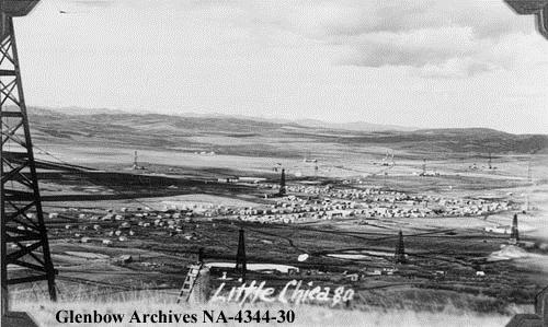
A few months back, we ran a blog post about the establishment of Alberta’s oil and gas industry at Turner Valley and the two major, and still extant, towns that developed to serve that industry – Turner Valley and Black Diamond. These two places were not the only communities that grew so suddenly and substantially with the discovery of oil in the region. In 1936, the Turner Valley Royalties Company struck oil near Longview Hill (known locally as “The Big Hill”). Oil workers again flooded to the region and numerous new communities were established. Two notable communities were given unofficial, and ironically refined, monikers – “Little Chicago” and “Little New York.”
Detail of the 1945 edition of NTS Map Sheet 82 J/09. Royalties and Longview are at the south end of the map. Although smaller than both Turner Valley and Black Diamond to the north, the two boom towns are shown as being of considerable size. Source: Department of Mines and Resources. Map 819A, Turner Valley, West of the Fifth Meridian, Alberta. Scale 1:63,360 (1 Inch to 1 Mile), 82 J/09. Ottawa: Government of Canada, 1945. Available from Natural Resources Canada. GeoGratis http://geogratis.gc.ca/geogratis/Home?lang=en.
Royalties (aka “Little Chicago”)
About 15 kilometres south of Turner Valley and Black Diamond along Highway 22 is the former community of Royalties. Little remains there today, but it was once a bustling community. Following the discovery of oil at the Turner Valley Royalties No. 1 well, a collection of shops and dwellings quickly grew nearby. In 1937, a post office opened at the town site and, due to the community’s proximity to and association with the nearby oil well, the post office and town site were given the name Royalties, but most of its residents and other locals did not use that name. Most of them called the community “Little Chicago.”
The precise origin of the name “Little Chicago” is not known, but there are a number of theories. One story is that the many American oil workers in the area ironically compared the frenetic activity of the little town site to the bustling mid-west American city. To further complement the comparison, a small slough near the town site became known as “Lake Michigan.” Another, and even more colourful origin story, concerns Rex Warman, the owner of the first store in the community. According to Rex’s wife Florence, her husband was known locally as “Little Al Capone” or “Little Scarface” due to a scar on his upper lip. Although, she also said that some people felt the store’s prices, marked high to cover transportation costs, were extortionist, which may have contributed to her husband’s Capone-esque nickname – Al “Scarface” Capone, being the legendary Chicago mob boss and rum-runner. It is an easy leap for the store location to become known as “Little Chicago.”
Little Chicago (Royalties), Alberta, 1940. Little New York (Longview) to the south and Little Chicago developed quickly after the 1936 oil strike in Turner Valley. (Glenbow Archives, NA-4344-30).
According to the local history Tales and Trails, at its height, Royalties consisted of a Hudson’s Bay store, two oil well supply depots, three trucking companies, a machine shop, three lumber yards, two garages, a furniture store, three grocery stores, many boarding houses, restaurants and a dance hall with a theatre. The boom times in Royalties did not last. As drilling tapered off, people and businesses left the community. The post office closed in 1969 and the sole remaining business, a gas station, shut down a short time later. Today, there is really nothing left on the landscape to show the existence of the community.
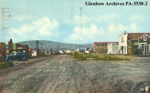
Longview (aka “Little New York”)
Located about 15 kilometres south of Turner Valley and Black Diamond (and four kilometres south of Royalties) is the village of Longview. Longview predates the discovery of oil and gas in the region, but the community flourished because of the oil. The name Longview came into official use when a post office of that name was opened in July 1908 in Section 25 of Township 18-2-W5. A number of possible origins for the name have been proposed. The most likely origin is that the name came about due to the location of the post office near the “Big Hill” which allowed one to see for a considerable distance, or have a “long view.” Other accounts suggest the community was named for Thomas Long, a schoolteacher who arrived in the area in 1895 and filed for a homestead on the hill.
View from the Longview Hill, November 1936. The oilfield community of Longview, or Little New York, was established near the foot of this prominent hill. (Glenbow Archives, IP-6d-3-13).
Historically, the Longview area had been associated with agriculture (ranching and farming); and today it is well known for its connections to Canadian country music (Ian Tyson shout out!). However, following the 1936 oil discovery, a boom town developed in Section 20 of Township 18-2-W5, about eight miles west of the Longview post office. Like Royalties to the north, the town site was quickly flooded with rig workers, their families and a range of associated camp followers. Mud-clogged or dust-chocked streets, depending on the weather, criss-crossed the community and inexpensive and rudimentary shacks were built practically overnight for use as houses, stores, banks and other services. The level of activity was so frantic that Longview became known, probably with a great deal of tongue-in-cheek, as “Little New York.” A local history of Longview suggests that the community’s residents did not want to be upstaged by “Little Chicago” up the road and did them one better by adopting the larger American city as their unofficial namesake.
Longview, Alberta 1940-1945. The community was known as “Little New York” following a 1936 oil discovery in Turner Valley. It was likely a sarcastic reference to the frantic pace of development at the town site. (Glenbow Archives, PA-3538-2).
In 1937, the Longview post office moved from the hill to the town site and the community became Longview, although it continued to be referred to as “Little New York” for many years. Towards the end of the 1940s, oil boom growth had settled and with it, so did the pace of development in the area. Unlike Royalties, which essentially disappeared, Longview continued to exist as a rather sedate little hamlet. On January 1, 1964, Longview, with a population of 206 was officially made a village.
Through history, many resource communities have been given ironic, unusual and occasionally ribald names. Often these names are not the ones that end up being approved by naming authorities for use on official maps. For many of these communities and places, such as Longview and Royalties, the unofficial names continue to be used by those most familiar with the place and its history. The culture and history of a place can be read through the names on its maps, but sometimes, the names not on the maps can tell us much more.
Written by: Ron Kelland, Historic Places Research Officer and Geographical Names Program Coordinator.
Sources and Additional Resources:
In the Light of the Flares: History of Turner Valley Oilfields, (Turner Valley: Sheep River Historical Society, 1979).
Tales and Trails: A History of Longview and Surrounding Area, (Longview: Tales and Trails History Book Society, 1973).