Heritage Marker Unveiling in Peace River

The Municipal District of Peace No. 135, which has been celebrating its centenary in 2016, hosted the unveiling of the two latest Provincial Heritage Markers on August 24. The first marker details the rich history of the region’s fur trade and the competition between the Hudson’s Bay Company and the North West Company, as well as the crucial participation of First Nations people as trappers and provisioners. The second marker highlights the history and growth of agricultural settlement in the area at Shaftesbury Settlement. The unveiling was attended by Leah Miller, Board Member of the Alberta Historical Resources Foundation, who brought greetings from the Board and Minister of Culture and Tourism, Ricardo Miranda.

Leah Miller, Board Member of the Alberta Historical Resources Foundation at the unveiling of the Shaftsbury Settlement Heritage Marker.
Leah Miller, Board Member of the Alberta Historical Resources Foundation, at the unveiling of the Shaftesbury Settlement Heritage Marker.

The Shaftesbury Settlement marker was installed at the St. Augustine’s Mission Site in September 2015, while the Peace River Fur Trade marker was installed at the site of the McLeod’s Fort Cairn on Highway 684 in December 2015. The Provincial Heritage Marker Program promotes greater awareness of the provincially-significant people, places, events and themes that have defined the history and character of our province. The public plays an important role in the program, and we welcome applications from groups or individuals who want to propose topics and locations for future markers, including our popular urban/trail-sized markers, suitable for placement in towns, parks, and other locations with pedestrian traffic. For more information about the program, please visit our website.

New Peace River Fur Trade Heritage Marker at the site of McLeod's Fort Cairn on Highway 684 in the Municipal District of Peace No. 135.
New Peace River Fur Trade Heritage Marker at the site of McLeod’s Fort Cairn on Highway 684 in the Municipal District of Peace No. 135.

Written By: Allan Rowe, Historic Places Research Officer

Mount Lougheed and Wind Mountain

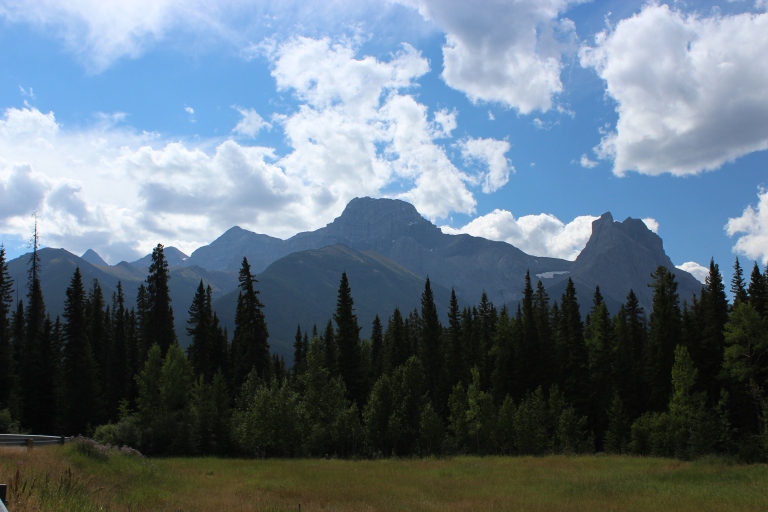
One of the most recognizable mountains in the Canadian Rockies is Mount Lougheed. Located approximately 15 kilometres southeast of Canmore, this majestic 3,150 metre (10,335 ft.) mountain is named for Sir James Alexander Lougheed. However, Lougheed is not the only name the mountain has had. In fact, it is not even the first mountain in the area to bear the name Lougheed. The story of how the mountain became known as Mount Lougheed is interesting.

IMG_0322

Mount Lougheed from the Trans-Canada Highway, August 2011. The entire massif is known as Mount Lougheed. The large, central peak is likely the feature named “Windy Mountain” by Eugene Bourgeau in 1858. The prominent peak furthest to the right is Windtower Mountain. The peak known today as Wind Mountain is the distinctly pointed peak visible on the horizon at left side of the photograph.
Source: Larry Pearson, Historic Places Stewardship Section, Alberta Culture and Tourism.

In 1858, Eugène Bourgeau (sometimes spelled Bourgeaux), a botanist with the Palliser Expedition, accompanied James Hector up the Bow Valley towards what is now Canmore. Bourgeau named many of the mountains and lakes along the way. Bourgeau was struck by the way the clouds swirled around one particular peak. James Hector, in his account of August 11, 1858, noted that Read more

Romanian Settlement in Alberta

One of the latest additions to the Provincial Heritage Marker collection details the history of Romanian settlement in Alberta, starting with the first Romanian pioneers to settle in the province in 1898, Ikum Yurko and Elie Ravliuk. The earliest Romanian settlements in Alberta were concentrated in the east-central part of the province, where communities such as Boian flourished in the early twentieth century. New Romanian-Albertan communities emerged in the late 1920s as the children of the first generation began to move to other parts of the province in search of land and new opportunities. By the 1950s the province’s Romanian population was predominantly Canadian-born, but Romanian culture, traditions and language still flourished in Alberta.

New Heritage Marker installed in June 2015 on Highway 45 east of Willingdon.

The marker was installed on Highway 45 east of Willingdon in June 2015. The Provincial Heritage Marker Program promotes greater awareness of the provincially-significant people, places, events and themes that have defined the history and character of our province. Topics relevant to the history of immigration, settlement and ethnic history has been an important part of the program since it was first launched in 1955. The public plays an important role in the program, and we welcome applications from groups or individuals who want to propose topics and locations for future markers, including our popular urban/trail-sized markers, suitable for placement in towns, parks, and other locations with pedestrian traffic. For more information about the program, please visit our website.

Written By: Allan Rowe, Historic Places Research Officer

Summer Idyll, Winter Wonderland

The Sturgeon River defines the St. Albert landscape

Earlier this year, the Alberta Heritage Markers Program installed a marker on the banks of the Sturgeon River in St. Albert. Our heritage markers can be found along walking trails and roadside pull-offs throughout Alberta, offering glimpses into the past.

This marker tells us how the people of St. Albert related to the Sturgeon River, which winds through their community.

An image of the new heritage marker along the Sturgeon River.
a new heritage marker along the Sturgeon River.

Summer Idyll, Winter Wonderland

Before it reaches St. Albert the Sturgeon River has meandered about 180 kilometres from its beginnings in Hoople Lake west of Isle Lake. After it leaves St. Albert the Sturgeon continues flowing eastwards to Fort Saskatchewan, and empties into the North Saskatchewan River.

For the people of St. Albert in the early 1900s the river was much more than an obstacle requiring bridges, much more than a method of winter transportation when snow blocked the roads. It became a place of wonder where small children watched tadpoles darting just beneath the surface and dragonflies glinting in the sun above it. It helped create memories not linked to the hard work of daily life. “Young men who were studying for the priesthood,” Jane Ternon Sherwood recalled, “paddled up and down the river … their Gregorian chanting drifting over the water on a warm summer evening was beautiful to hear.”

The Sturgeon River became landmark and destination, the passing of time measured by seasonal opportunities to have fun and build community. On its banks and in its refreshing summer waters families played, groups held picnics and went boating, and young people paddled Sunday afternoons away. “In the winter, it was our skating rink and landing spot when we slid down the bank on our sleds,” recalled Dorothy Bellerose Chartrand. It was a hockey rink too where tin cans and frozen horse manure stood in for pucks.

For a brief time a steamer, La Thérèse, chugged lazily up and down the river. “I believe the river was much bigger then,” Jane Ternan Sherwood reminisced in the 1980s, remembering riding in the steamer in 1912. Memory had made the Sturgeon wider and more exciting, rekindling the joy of a small child splashing happily at its edge.

If you’d like to visit the marker, it can be found here:

Prepared by: Michael Thome, Municipal Heritage Services Officer.

Dutch Settlement

You have all probably seen them – large blue heritage markers located at highway rest areas or points of interest throughout Alberta. These interpretive signs tell of Alberta’s rich heritage. Come, travel Alberta and read a featured heritage marker:

Driving westward on Highway 18, about 3 kilometers east of the intersection with highway 33 (near the Town of Barrhead) I came across a heritage marker commemorating Alberta’s first Dutch settlers. The sign is about 19 kilometers south of the Hamlet of Neerlandia. Why is Neerlandia special? The sign explains:

Dutch Settlement

“Wij gann naar Alberta!” We are going to Alberta! This was the call of thousands of Dutch settlers who immigrated to Alberta in the early 1900s. A booming economy and the promise of free homesteads attracted Dutch immigrants from Holland and from the American Midwest. By 1911, Alberta’s Dutch population of 2,951 was the largest in Canada.

Most Dutch immigrants settled throughout Alberta on homesteads, or in the province’s growing towns and cities. There were several areas, though, where the Dutch presence was particularly strong. In 1904, Dutch immigrants from Holland and America settled near Monarch and Nobleford, while in 1908 nearly 100 families from North Brabant, Holland, settled near Strathmore. In 1912, a group of Dutch immigrants living in Edmonton established the colony of Neerlandia, near Westlock, the province’s only exclusively Dutch settlement.

More Dutch immigrants came to Alberta after both world wars and continued making contributions to Alberta’s political, economic, and cultural life just as the first pioneers had done.

Note: The text on the sign is repeated in Dutch. To view, click on the below photo.

Heritage Marker Location

On the north side of Highway 18 approximately 3 kilometers east of Highway 33, near the Town of Barrhead.

Alequiers is a Provincial Historic Resource located near Longview in the M.D. of Foothills, in southern Alberta. Although it’s not located near this sign, the property is associated with the well know painter Ted Schintz. Schintz migrated to Canada from Holland during the 1920’s.

Prepared by: Michael Thome, Municipal Heritage Services Officer

Klondike Trail

You have all probably seen them – large blue heritage markers located at highway rest areas or points of interest throughout Alberta. These interpretive signs tell of Alberta’s rich heritage. Come, travel Alberta and read a featured heritage marker:

Driving westward on Highway 18, I found this roadside sign a few kilometers east of the Highway 33 intersection, near the Town of Barrhead. Stopping to read it, I learned how close I was to the “all Canadian” route to the Klondike, used during the gold rush. Continuing on my way, I used part of the trail (now Highway 33) to get to High Prairie.

Klondike Trail

When gold was discovered on the Klondike River in 1896, a frenzy swept North America. By 1897 a full-scale gold rush was on. Most “Klondikers” traveled by ship to Skagway in Alaska before crossing the White and Chilikoot Passes to the Yukon. Some, however, chose alternative routes. The Canadian government, the Edmonton Board of Trade, and Edmonton merchants promoted use of an “all Canadian” route. Gold seekers were encouraged to travel from Edmonton to the Yukon via the Peace River Country. Existing trails were very rudimentary, so the government hired T.W. Chalmers to build a new road between Fort Assiniboine and Lesser Slave Lake.

After an initial survey in September 1897, construction of the road was started in the spring of 1898. The Chalmers or Klondike Trail began on the Athabasca River at Pruden’s Crossing, near Fort Assiniboine. Located to the east of this sign, the trail skirted the present site of Swan Hills before following the Swan River north to what would become Kinuso. From there, travelers followed the shore of Lesser Slave Lake west before turning north to the goldfields – a mere 2,500 kilometers away.

The trail followed a very difficult route and was a challenge to all. Countless numbers of horses perished along the way, and travelers’ accounts describe the back-breaking labour and dangers of this trail. By 1901-02 use of the trail declined, and soon after it was abandoned altogether in favour of other routes to the Peace River area. Highway 33, just east of here, roughly follows the route of this early trail, which is linked to one of the most colourful episodes in Canadian History.

Heritage Marker Location

North side of Highway 18, 1 kilometer east of Highway 33.


Prepared by: Michael Thome, Municipal Heritage Services Officer

The Signing of Treaty No. 8

You have all probably seen them – large blue heritage markers located at highway rest areas or points of interest throughout Alberta. These interpretive signs tell of Alberta’s rich heritage. Come, travel Alberta and read a featured heritage marker:

Driving towards High Prairie on Highway 2, I encountered this roadside sign a few kilometres past the western tip of Lesser Slave Lake. Stopping to read it, I didn’t realise how close I was to the place where one of the numbered treaties was signed.

The Signing of Treaty No. 8

Treaty No. 8 was first signed on 21 June 1899 north of here at the western end of Lesser Slave Lake. Spurred by the discovery of gold in the Yukon in 1896, and growing agricultural settlement in the region, Treaty No. 8 was one of a series of treaties the federal government made with the First Nations of Canada.

The signatories for the First Nations of the Lesser Slave Lake area were: Chief Keenooshayoo, Moostoos (Sucker Creek), Felix Giroux (Swan River), Weecheewaysis (Driftpile), Charles Neesuetasis (Sawridge), and The Captain (Sturgeon Lake). Treaty Commissioners David Laird, J.A.J. McKenna, and J.H. Ross represented Her Majesty, Queen Victoria. There were also representatives from the Roman Catholic and Anglican churches and the North West Mounted Police present at the signing.

The First Nations who signed were promised reserves, education, medicines, annual payments, farm equipment, stock, seed, and ammunition, along with the freedom to hunt, fish and trap and other rights. After careful consideration and negotiation, the First Nations agreed to sign the Treaty. Adhesions to Treaty No. 8 were signed between July 1899 and 1914.

The Treaty Commission also traveled with a Scrip Commission which issued certificates called scrip to area Métis. These certificates entitled the bearer to either 240 acres of land or $240 towards the purchase of land.

Heritage Marker Location

North side of Highway 2, about 15 kilometres east of the town of High Prairie. https://goo.gl/maps/1H6QBZtfYkn

St. Bernard Mission (Church and Cemetery) is a Provincial Historic Resource located nearby in the hamlet of Grouard. Bishop Grouard was a famous Roman Catholic oblate missionary. Bishop Grouard encouraged many tribes to sign Treaty No. 8.

Prepared by: Michael Thome, Municipal Heritage Services Officer

The Burmis Tree: The Most Photographed Tree in Alberta?

At the end of April when travelling in southern Alberta on business I had time to visit the Frank Slide Interpretive Centre (to read about my visit, click here). While driving to Frank I turned through a bend in the road to suddenly find myself in front of a snow-capped mountain framed by a beautiful rainbow! The shutter-bug in me could not resist the temptation. With camera in hand I trundled out of my vehicle to take some photos. But wait, this blog post is not about mountain views and rainbows…

Upon turning my back on the rainbow to return to my vehicle, I discovered another beautiful site – the Burmis Tree! The Burmis Tree is a limber pine that marks the eastern edge of the Crowsnest Pass. Limber trees have one of the longest life spans of any tree in Alberta and are known for their ability to thrive in harsh conditions. As a standing testament to these facts, the Burmis Tree lived for approximately 700 years. It died in the late 1970’s but remained standing until 1998 when high winds toppled it over. The community, which regarded the tree as a significant landmark, refused to simply leave it. Rods and brackets were used to support the tree. To this day it still stands as a landmark, acting as a welcome sign to visitors of the Crowsnest Pass and as a symbol of home for area residents.

The leafless, gnarled tree simply needed to be photographed (if you are also a shutter-bug you will understand). As I explored the area photographing the tree from different angles, I next stumbled upon one of the heritage markers erected by the Government of Alberta and the Alberta Historical Resources Foundation. You have all probably seen them – large blue signs located at highway rest areas or points of interest throughout Alberta. These interpretive signs tell of Alberta’s rich heritage. This sign provides context for the Burmis Tree.

Assuming that the Burmis Tree is perhaps one of the most photographed trees in all of Alberta, I did a quick search on Flickr. Check out some of the photos. 

Do you have a photo of the Burmis Tree that you would like to share with readers of RETROactive? If so, email it to me at albertahistoricplaces@gov.ab.ca by June 10, 2012 with a completed copy of the Government of Alberta’s Photograph, Video, Name and Quotation Release Form. A future blog post will feature the submissions.

 Written by: Brenda Manweiler, Municipal Heritage Services Officer

Cheese Please!

You have all probably seen them – large blue heritage markers located at highway rest areas or points of interest throughout Alberta. These interpretive signs tell of Alberta’s rich heritage. Come, travel Alberta and read a featured heritage marker:

Alberta’s First Cheese Factory

When the Canadian Pacific Railway arrived at Fort Calgary in 1883, the cattle industry in the region was given a great boost. The CPR also made it possible for homesteaders to settle in the foothills, and a number of small mixed farming operations developed in addition to the large cattle ranches. One of the first homesteads in Springbank was begun by Ebenezer Healy.

Alberta's First Cheese FactoryHealy was a Nova Scotian who had learned the dairy business on his family’s farm in the Annapolis Valley. He traveled to Winnipeg in 1882, and the following year filed for a homestead north of Regina. Drought conditions there ruined his crops and helped persuade him to move further west to the foothills. Here he filed for another homestead where he could concentrate exclusively on raising cattle.

With Calgary’s growing population, Healy decided that the market for dairy products could be expanded to include cheese in addition to milk, cream and butter. With the co-operation of his neighbours, he decided to build a cheese factory and sent away for the equipment necessary to process the milk from 300 cows. In July 1888, he hauled his first shipment of cheese to the I.G. Baker store in Calgary where it retailed for 20 cents a pound. By 1890 his cheese factory produced 10 tons of cheese. This success encouraged the construction of other cheese factories in the area. Cheese production soon became a viable local industry in the southern foothills.

Heritage Marker Location 

South side of Highway 1, one kilometre west of Highway 22.

Alberta Register of Historic Places

If you would like to read more about Alberta’s dairy industry check out these Provincial Historic Resources on the Alberta Register of Historic Places:

Donalda Creamery, Donalda AB

Markerville Creamery, Markerville AB

Prepared by: Brenda Manweiler, Municipal Heritage Services Officer

Did you know… ?

Did you know that the discovery of oil near Turner Valley, in 1914, resulted in the first major oil boom in western Canada? When returning from a business trip in southern Alberta I stopped at the Turner Valley Oil Field heritage marker and learned about the birth of Alberta’s oil industry.

To learn more, check out the video below or scroll down to read the heritage marker text.


Heritage marker location: on the west side of Highway 22, north of the Town of Turner Valley.

Learn about other aspects of Alberta’s heritage in the Turner Valley area – explore the Alberta Register of Historic Places and read about various Provincial Historic Resources:

Written by: Brenda Manweiler, Municipal Heritage Services Officer


Heritage marker text:

Alberta’s History: Turner Valley Oil Field 

In the nearby town of Turner Valley is the discovery well of the first major oil and gas field in Alberta, drilled by Calgary Petroleum Products. Dingman No. 1, named after a major stockholder, blew in on May 14, 1914. The well produced large quantities of gas and light oil and began Alberta’s first oil boom. With the boom came a flood of stock speculation, but by late that summer the boom had collapsed. Many new oil companies had proven fraudulent, other wells were disappointing, and soon the investment capital that was needed for more development was focused on the war effort instead. 

The second boom began in 1924 with the Royalite No. 4 well owned by Imperial Oil. Royalite No. 4 produced even more of the light-gravity oil called naptha than the discovery well, but was not deep enough to reach the crude oil below. In June 1936, a new well discovered extensive oil deposits at 2,081 metres. This well, called Royalties No. 1, produced almost 1,000 barrels of oil a day, reviving interest in oil exploration in the field. By late 1936 the whole Turner Valley field was producing about 10,000 barrels per day. 

From 1914 to 1947, Turner Valley produced nearly all of Alberta’s petroleum, and it remained Canada’s most important oil field from 1925 until the discovery of oil south of Edmonton, near Leduc, in 1947.