Written by: Robert Gustas, PhD, Geomatics Technologist, Archaeological Survey of Alberta
The Archaeological Survey of Alberta is excited to release a complete volume of our latest Occasional Paper Series (No. 44) available for free download here.
The current volume is dedicated to synopses or components of graduate theses and dissertations written over the last 15 years. The initial six articles were released in April and the final four articles are featured below. They explore projectile points, the use of space at archaeological sites, and a bison skull ceremonial feature.
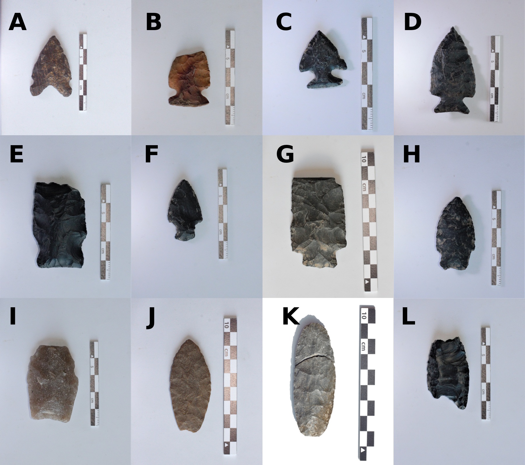
The seventh article in the volume compiles information about projectile points in the Peace Region to inform cultural contact, technologies, and chronological change. Northeastern British Columbia and northwestern Alberta were fluid places with long histories of cultural influence from neighbouring regions that are detectable in the shape and function of lithic artifacts.
A composite of some of the variety of projectile point morphologies in northeastern British Columbia. Source: Jen Hogan, 2025.
Written by: Todd Kristensen, Archaeological Survey of Alberta and Robert Gustas
The Archaeological Survey of Alberta is pleased to kick-off Occasional Paper Series No. 44 with its first six articles, which are available for free download.
The Occasional Paper Series is an annual volume of articles that explore cultural heritage in Alberta and surrounding regions. The first volume was published in 1976 and the current volume celebrates the series’ 50-year-anniversary. This issue is dedicated to sharing synopses or components of particularly insightful graduate theses and dissertations written over the last 15 years.
The volume is dedicated to archaeology in Alberta’s Rocky Mountains, Foothills and their margins. The initial three articles were released in Spring; below are summaries for the remaining six articles. They explore projectile points, caches, plant residues and more.
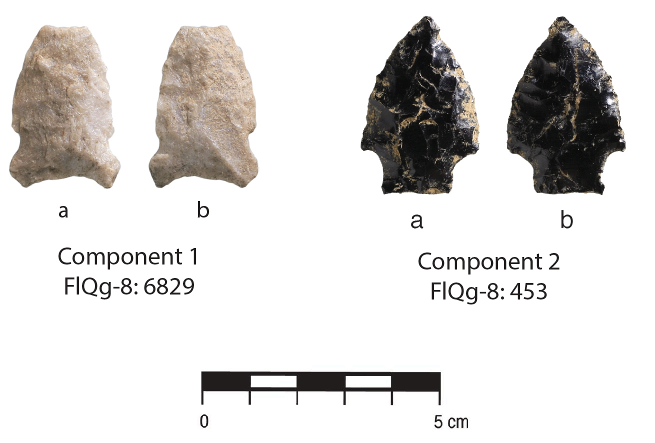
The fourth paper in the volume explores Oxbow and McKean stone tool assemblages at a site northeast of Hinton, Alberta. Taylor Graham applies statistical analyses to tease apart reduction events among the 6,000 artifacts recovered.
Projectile points recovered from FlQg-8. Source: Graham, 2024.
Editor’s note:The research presented in this blog is from a published journal paper co-authored by Timothy Allan, John Ives, Robin Woywitka, Gabriel Yanicki, Jeffrey Rasic and Todd Kristensen.
Ice sheet margins derived from: Dalton, A. S., M. Margold, C. R. Stokes, L. Tarasov, A. S. Dyke, R. S. Adams, S. Allard, et al. 2020. An Updated Radiocarbon-Based Ice Margin Chronology for the Last Deglaciation of the North American Ice Sheet Complex. Quaternary Science Reviews 234: 106223–27. https://doi.org/10.1016/j.quascirev.2020.106223.
Written by: Todd Kristensen, Archaeological Survey of Alberta
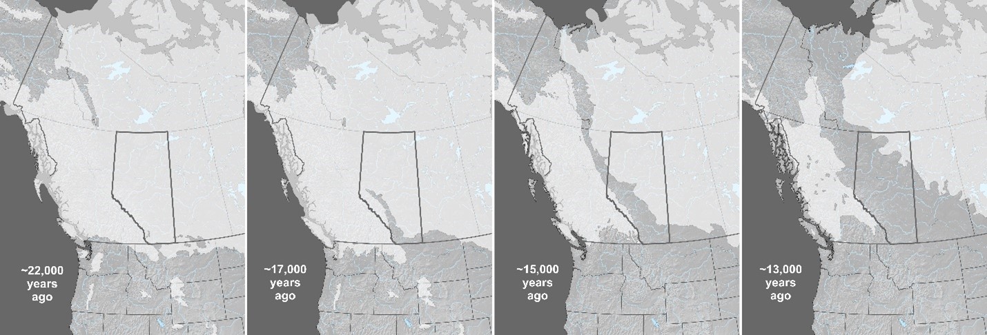
Alberta was once covered with glacial ice. Around 22,000 years ago, portions of the ice that sprawled across the province were over 1.5 kms thick. When the ice began to melt, it retreated in two directions (northeast and west) and exposed a pathway dubbed the Ice-Free Corridor that crossed through Alberta and connected previously exposed land masses over the warmer United States and a colder but drier region to the north called Beringia (parts of Northwest Territories, Yukon, Alaska, and Russia). People had settled into the corridor in what is now Alberta by 13,000 years ago. Where did they come from?
The melting of ice sheets over Alberta from roughly 22,000 to 13,000 years ago (based on data from Dalton et al. 2020). The ages are ‘calibrated’ from radiocarbon dates.
New archaeological discoveries are pushing back the ages of when people arrived in Beringia and to the south in the United States. To help understand which of those two areas are the likely source of people who came to Alberta, archaeologists have recently looked at the tools they were carrying, specifically, what kinds of stone the tools were made of. Some of the rock types that people used to craft things like spear points, scrapers and knives, are only found in certain areas in North America: their presence in Alberta’s archaeological record indicates that the stones were transported from far away. In turn, archaeologists look at changes in those ‘toolstone’ materials to track changing relationships; in the absence of other things that don’t preserve in Alberta’s soil, stone tools reveal where people migrated from, who they were interacting with (their ‘kin’) and how that all changed over thousands of years.
Editor’s note: The Archaeological Survey of Alberta is proud to release the complete volume of Occasional Paper Series No. 42, available for free download.The volume is dedicated to Alberta archaeologist Jack Brink and the initial blog featured the first five articles. This post features the remaining seven articles, which focus on a variety of archaeological topics.
Written by: Todd Kristensen, Archaeological Survey of Alberta
In the sixth paper of the volume, staff of Lifeways of Canada Limited summarize three seasons of excavation at an important archaeological site in southern Alberta. The Junction Site has produced a number of interesting pit features associated with Late Precontact Period bison kills, processing areas and winter camp activities.
A boiling pit feature and profile from the Junction Site. Source: Vivian and Blakey, 2023.
Editor’s note: The Archaeological Survey of Alberta is proud to release the complete volume of Occasional Paper Series No. 42, available for free download.
Written by: Todd Kristensen, Archaeological Survey of Alberta
Cover of the 2023 Occasional Paper Series. Artwork by Shannon Ford.
Unlike previous volumes, in which papers are published and released throughout the year, the current volume is based on an archaeology conference session dedicated to the widely respected Alberta archaeologist Jack Brink, and all articles are here released concurrently. This blog features five articles (out of 12 in the issue) that focus on archaeological work at the famous Head-Smashed-In Buffalo Jump UNESCO World Heritage Site in southern Alberta. The rest of the 12 articles will be published next week.
Written By: Colleen Haukaas, Archaeological Survey
This post looks at archaeological sites recorded in Alberta under 2022 archaeological permits issued by the Archaeological Survey. Part One of this post has more information about archaeological permits, field activities, and professional activities.
The majority of sites each year are recorded during CRM projects in response to potential impacts from proposed developments. Researchers in universities, museums, and other research facilities also record sites each year. Together, archaeologists record and re-record (revisit) 500-700 sites annually.
There are more than 40,000 known sites recorded in Alberta, ranging from small scatters of a few artifacts to complex sites like the Quarry of the Ancestors, Áísínai’pi, and Cluny Fortified Village sites. The infographic below shows basic categories of information about sites recorded in 2022, including site class and type.
You can explore previous Survey in Numbers to compare statistics year over year
Written By: Colleen Haukaas, Archaeological Survey
This week’s post is an update on 2022 archaeological permits from the Archaeological Survey of Alberta. All archaeological field research in Alberta must be carried out under a permit issued by the Archaeological Survey by a qualified professional archaeologist. In 2022, the Archaeological Survey issued 209 permits to 53 professional archaeologists at 19 companies.
As in previous years, the majority of permits were issued for mitigative assessments, or assessments to determine if a proposed development may impact a known of potential archaeological site. The majority of assessments were Historical Resources Impacts Assessments (HRIAs), which are generally preliminary examinations intended to determine whether a development will impact archaeological sites. More detailed site excavations are less common in mitigative archaeology, but do occur when sites cannot be avoided by a development. In 2022, mitigative archaeologists carried out 194 assessments, which included the excavation of more than more than 27,000 shovel tests and 476 square meters of formal site excavation.
The infographic below includes details about archaeological permits and assessments, based on information provided to the Archaeological Survey in permit applications, reports and other reporting materials.
Part two of this post will discuss the archaeological sites recorded in 2022.
You can explore previous Survey in Numbers to compare statistics year over year.
Issue 41 of Alberta’s Occasional Paper Series is now available online at the Archaeological Survey of Alberta publications page. Readers can download a free copy of the complete issue (focused on archaeology in Western Canada’s Boreal Forest) or peruse individual papers about: forestry-based CRM archaeology, ground stone tools in northeast BC, early sites in Alberta’s Boreal Forest (e.g., Clovis and Scottsbluff), the use of GIS to monitor impacts and identify landforms, fur trade archaeology and radiocarbon dates to inform population estimates in the Boreal Forest.
Editor’s note: The banner image about was reproduced with the permission of the Provincial Archives of Alberta. Sled dogs were critical for moving goods in northern Alberta, like this dog team outside a trade post in the Fort McMurray area in 1911.
Written by: Todd Kristensen, Archaeological Survey of Alberta
Domestic dogs have likely been in Alberta for least 5,000 years and some researchers think they arrived with the first humans in North America over 13,000 years ago. What role did they play in Indigenous life? And how did that role change when horses arrived in the 1700s?
Based on archaeological records and historic accounts, people on the prairies of southern Alberta likely had about 4-6 dogs per family. These pets could transport about 90-270 kg of goods using a travois (a series of poles attached to a dog’s back) or pack saddles. Dogs helped move tipi hides and poles (up to 100 kg per tipi) as well as dried meat and tools from camp to camp. Before Europeans arrived, Plains communities packed up and moved all of their belongings about 10-40 times a year, which helped them stay in contact with moving bison herds that were the main source of food and materials. Trains of several hundred pack dogs carried goods on trading expeditions.
A comparison of horse and dog characteristics that influenced their relationships with people in Alberta. Illustration by Terra Lekach.