Written by: Ron Kelland, Geographical Names Program Coordinator
In July 2021, Canada is marking Historic Places Day, or Days as the case may be. First declared in 2017, Historic Places Day is an initiative of The National Trust of Canada as an opportunity to highlight historic places across Canada, to tell their stories and encourage Canadians to learn about, experience and interact with them to foster a better appreciation of the important role these places have in the lives of Canadians and how they impact the quality of life in our communities.
Historic places take many forms, from old and grand public buildings and monuments to small and homey bungalows and farmhouses, to workers cottages, archaeological and paleontological sites, museums and cenotaphs. With summer now here and people looking for opportunities to enjoy the outdoors, we thought it opportune this year to feature some of Alberta’s parks and outdoor public spaces that have been designated as historic resources. So, grab your walking shoes or hiking boots, bring your camera and lots of water, and let’s explore some these historic parks across the province.
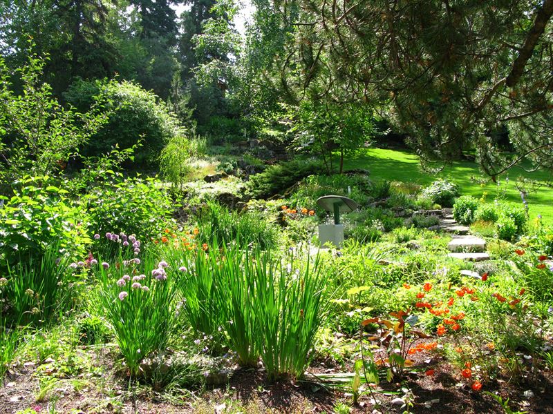
Located adjacent to Calgary’s Union Cemetery, the Reader Rock Garden is an early twentieth-century naturalistic garden composed of rocks, primarily local sandstone; trees; water features; and paths. The garden was designed by William Roland Reader, superintendent of parks and cemeteries for the City of Calgary from 1913 to 1942. Reader was heavily influenced by the City Beautiful movement, which advocated for the inclusion of well-designed green spaces in urban environments. Under Reader’s leadership, Calgary saw the establishment of many parks, playgrounds, golf courses and tennis courts around the city and the planting of trees along city streets. Reader created the Rock Garden as a semi-private park, it was located around the superintendent’s cottage, now a reconstructed elements in the park, and as a living, laboratory where he experimented with thousands of varieties of plants. Reader’s botanical experiments and meticulous observations influenced horticulture across North America through his writings and the distribution of seeds.
Editor’s note: Our first article recognizing #HistoricPlacesDays takes us to southern Alberta. The banner image above, featuring low-lying rear lots with gardens in Lethbridge’s Chinatown in 1956, looking west, is courtesy of the Galt Museum and Archives.
Written by: Fraser Shaw, Heritage Conservation Advisor
Since its construction in 1924, the Chinese Free Masons Building has been an anchor in the physical and social fabric of downtown Lethbridge and on of Alberta’s most intact historic “Chinatowns”. A large crack zigzags across the west wall of the Provincial Historic Resource and propagates east down the block, telegraphing through the walls of its historic neighbours and terminating at the old No. 1 Fire Hall. The crack recently presented repair challenges and is the legacy of a historic landscape and a transformed physical and cultural geography.
1990s photograph from the northwest with the west wall crack and previous repairs clearly visible toward the back (right) half of the building. Source: Historic Resources Management Branch.
Some 12,000 years ago, as the Laurentide ice sheet retreated toward Hudson Bay, torrents of meltwater carved deep channels across southern Alberta, including today’s Oldman River valley. Long tributary coulees reached like fingers from the valley’s east side, a pattern evident today along the escarpment behind the Galt Museum. One of these coulees extended east between what is now 2nd and 3rd Avenue South and appears in early plans and photographs of Lethbridge. Uneven and difficult to build on, the block attracted Chinese immigrants and entrepreneurs who established new businesses on lots that were strategically close to the fledgling town centre but slightly apart from it, a development pattern reinforced by discriminatory policies of the day that relegated Chinese-owned businesses to marginal land away from the commercial core.
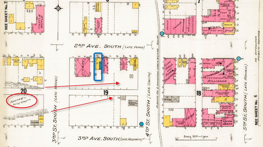
A fire insurance map of 1910 predates the construction of the Chinese Free Masons Building on Block 19 Lot 5 (blue outline) but notes infilling of the ravine or coulee (circle at lower left). Arrows indicate the original extent of the coulee eastward through Block 19. Source: Library and Archives Canada, with added annotations.
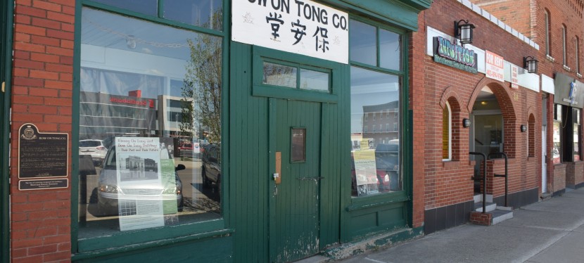
Development has infilled the coulee such that the historic landscape today survives only in the sunken rear lots of the Bow On Tong Company Building and Wing Wah Chong Company Building, both of which are Municipal and Provincial Historic Resources. These low-lying back yards were historically put to good use, providing direct access to basement apartments for newly arrived immigrants from China and serving as vegetable gardens (see banner image at top of page). Though hidden, the buried coulee survives as relatively weakly consolidated infill soil under the back portions of the block’s historic buildings. These areas move and crack as soil compacts, takes up water from the poorly drained rear lots, or moves seasonally where shallow rear foundations are susceptible to frost heave. The rear lot at the Chinese Free Masons Building has been infilled but unstable soil conditions persist and cause structural movement and recurrence of the west wall crack despite repeated patching.
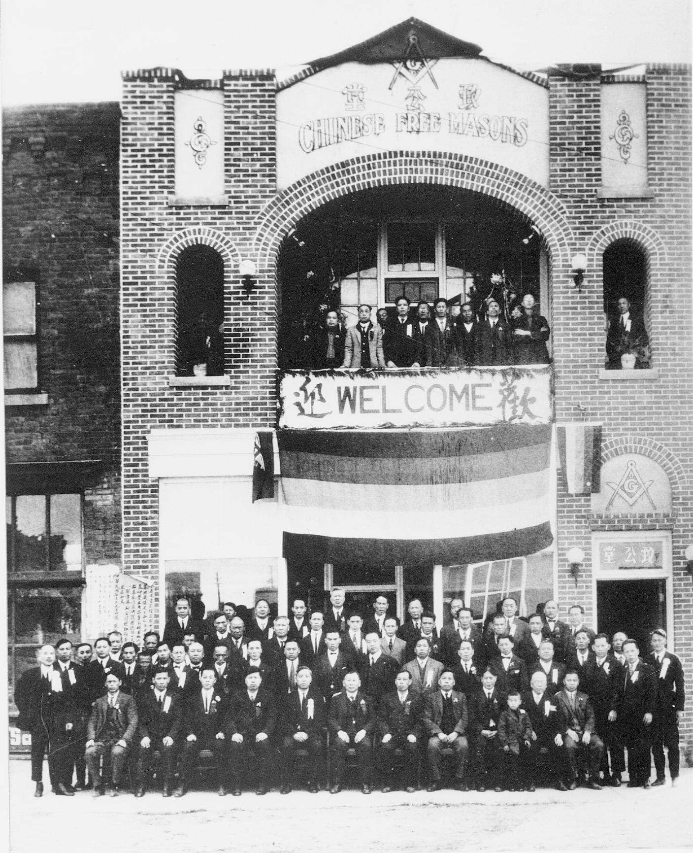
1924 photograph, possibly showing the Masonic hall’s grand opening. Source: Galt Museum and Archives photograph 19800128000.
Foundation underpinning on deep piles into undisturbed soil would stop the structural movement and cracking but is very costly. A local architect assessed no immediate threat to the building and recommended a practical and cost-effective crack repair alternative. This consisted of saw cutting a new flexible control joint into the outer wythe or layer of brick beside the old crack, to accommodate ongoing structural movement while maintaining integrity as a weather seal. The existing crack was too irregular for proper installation of a reliable sealed joint. As a precaution, the established crack was also repaired with flexible sealant, into which masonry sand was pressed to resemble a traditional mortar joint and disguise the repair as much as possible.
Conservation work normally favours traditional materials but a deep mortar repair risked “locking” the wall in place and causing cracks to appear elsewhere. Correctly formulated lime mortars can absorb some movement and even “self heal” as free lime recrystallizes within emerging hairline cracks — but structural movement at the Free Masons Building demanded a more elastic joint.
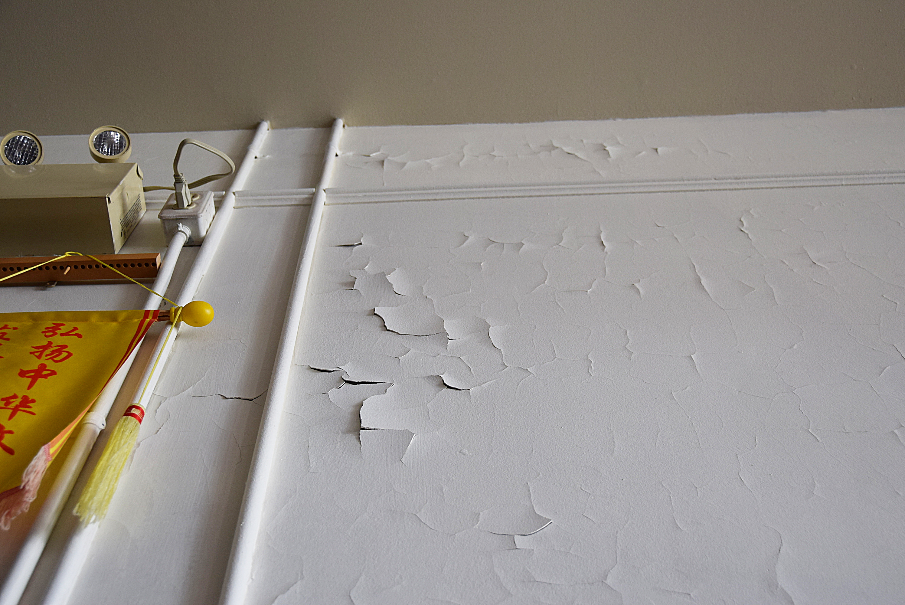
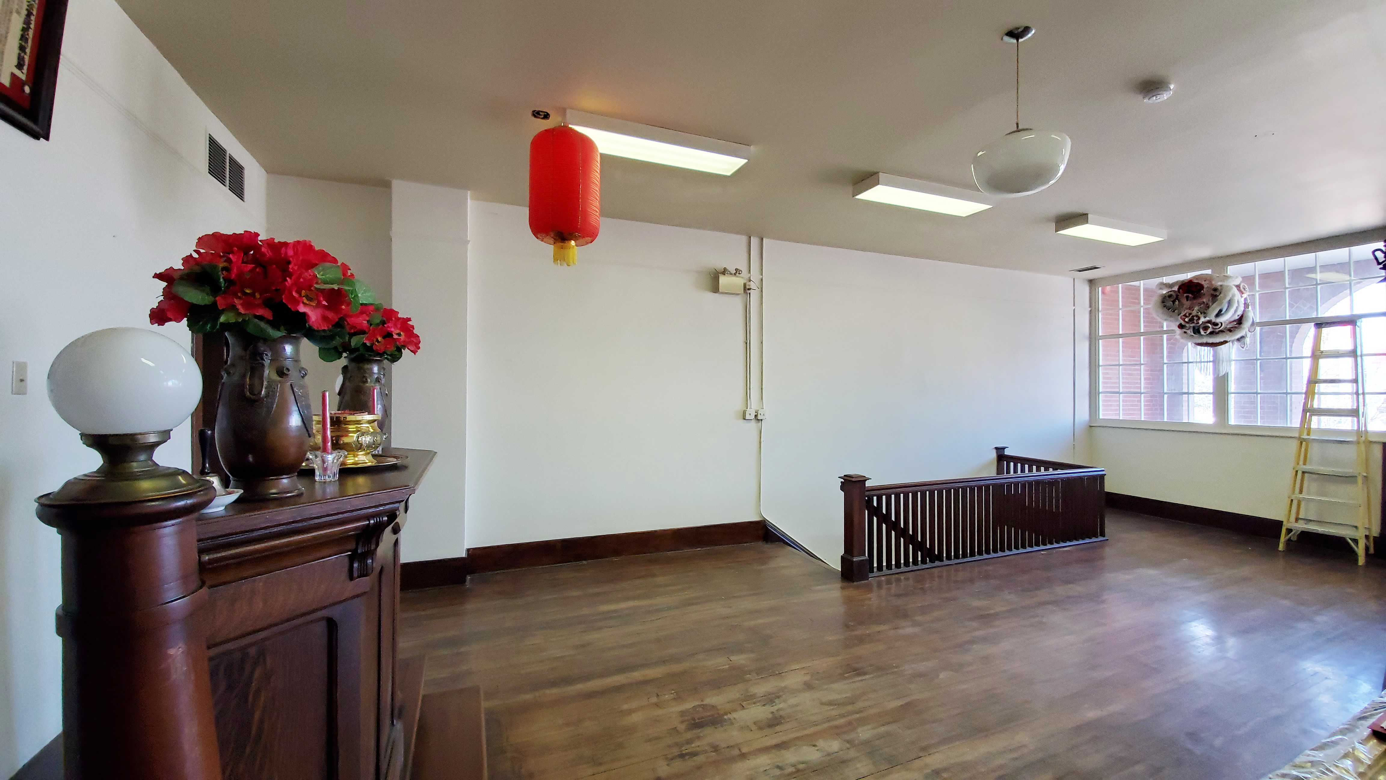
Paint failure on second floor interior west wall, April 2019. Source: Historic Resources Management Branch.
The second floor offers a large open space that has served as a Masonic hall for almost a century. The interior walls are original plaster applied to the interior face of the brick masonry exterior walls. Coated with many layers of paint, the walls deteriorated rapidly after the interior was repainted to hide smoke damage after a fire in 2009. Driving rain through the west wall crack was initially suspected as a moisture source but the extensive paint failure was actually in another location. Further assessment determined that the problem was excess moisture within the wall combined with the wall’s inability to dry through impermeable layers of paint.
The west wall is thus a highly porous brick that readily absorbs moisture. Like many old brick buildings, the Chinese Free Masons Building uses a high-quality, durable brick on the front facade with less expensive bricks on the side walls that were often intended to be protected by adjacent buildings. Mortar joints also play a role: lime mortar both binds the masonry and actively wicks moisture in the wall to the surface, where it then evaporates. However, as mortar weathers, leaching of the lime binder reduces this wicking action and eroded joints provide more surface area for water absorption, effectively turning a wall into a sponge. On the wall’s inner face, permeability declines with each layer of paint and as old alkyd paint ages. The most recent repainting was the last straw: acrylic latex paint is vapour-permeable but drying of the wall fabric relies on liquid (if microscopic) capillary moisture transfer. The result is that moisture absorbed through the exterior brick trapped within the wall literally pushes the paint off the plaster.
Second floor (Masonic hall) with far wall after plaster repairs and application of clay paint, March 2021. Source: Historic Resources Management Branch.
To correct the problem, peeling interior paint was stripped by hand and moisture-damaged plaster was patched with a compatible gypsum plaster free of latex or polymer additives that might otherwise impede prevent drying. A special, highly permeable clay-based paint was applied to the wall and colour-matched to the historic interior. Combined with renewing or “repointing” the exterior masonry with a compatible lime mortar, these measures avoid sealing the wall and instead restore the historic fabric’s intrinsic ability to absorb, buffer and release moisture by drying to the interior and exterior. The repaired west wall with its new control joint and evidence of the old crack are a testament to ancient landforms, local history and Lethbridge’s evolving urban landscape.
View from northwest in June 2021 with new control joint on west wall and muted expression of historic crack. Source: Historic Resources Management Branch.
Sources:
C.B. Beaty and G.S. Young, The Landscapes of Southern Alberta: A Regional Geomorphology (Lethbridge: University of Lethbridge, 1975), 66-77.
For a discussion of the early development of Lethbridge’s Chinatown, see David Chuenyan Lai, Chinatowns: Towns Within Cities in Canada (Vancouver: University of British Columbia Press, 1988), 90-91.
Written by: Fraser Shaw, Heritage Conservation Advisor
Paskapoo sandstone has been maligned for poor durability, compared to Indiana limestone and sandstones from Ohio or Spain that have been used for conservation projects in Alberta. But to be fair to our homegrown sandstone, masonry in general suffers in Alberta’s climate and in the intense sunlight, drying winds and freeze-thaw cycling in areas like southern Alberta. De-icing salts used for public safety during the long winter months are the nemesis of historic masonry and will relentlessly attack sandstone, limestone and granite alike. How stone is laid in a wall, masonry mortar composition, and design details all contribute to how stone performs over time.
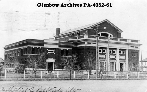
An imposing landmark in downtown Lethbridge, Southminster United Church is a large 1913 building (additions in 1914 and 1950) with a bold Modernist 1961 chapel. The Classical Revival original building dominates with its symmetrical front facade, prominent pediment, monumental engaged columns and exterior of buff-coloured brick with sandstone details. Interestingly, while stone decoration of the 1950 north addition superficially resembles the regional sandstone, it is actually imported Indiana limestone, a different and relatively durable material. Other notable Lethbridge buildings with this combination of local and imported stone are the Galt Museum (former Galt Hospital) and the Bowman Arts Centre (Manual Training School), both Provincial Historic Resources. Lethbridge designated Southminster United Church as a Municipal Historic Resource in 2016.
Circa 1915 photograph from the southwest showing the original 1913 building with its prominent columns and pediment and the 1914 hall addition at left. Source: PA-4032-61, University of Calgary Glenbow Archives Collection.
Editor’s note: Welcome to the final post in a series of blog posts developed with municipalities in mind who either have or are considering undertaking Municipal Historic Resource designation. In this post, we will discuss how the evaluation of a historic resource at the provincial and municipal level may result in complimentary or differing heritage values. You can read the previous post here.
For more information, please review the “Creating a Future” manuals available here or contact Rebecca Goodenough, Manager, Historic Places Research and Designation at rebecca.goodenough@gov.ab.ca or 780-431-2309.
Written by: Fraser Shaw, Heritage Conservation Adviser and Ron Kelland, Historic Places Research Officer, Historic Resources Management Branch
Complementary and differing values
Alberta’s Historical Resources Act empowers both the Government of Alberta and municipalities to designate, or recognize and protect, a range of historic resources whose preservation is in the public interest. These resources can be places, structures or objects that may be works of nature or people (or both) that are of palaeontological, archaeological, prehistoric, historic, cultural, natural, scientific or aesthetic interest. Albertans value these historic resources because our past, in its many forms, is part of who we are as a society and helps give our present significance and purpose.
As of July 2020, there are currently 390 Provincial Historic Resources (PHR) and 413 Municipal Historic Resources (MHR) in Alberta, some 60 of which are designated both provincially and municipally. These resources merit designation for various reasons, from their association with significant events, activities, people or institutions; as representative examples of architectural styles or construction methods; for their symbolic and landmark value; or their potential to yield information of scientific value.
Heritage values are described in short Statements of Significance, which are listed on the Alberta Register of Historic Places. In this post, we look at examples of heritage values that municipal and provincial governments recognize and how local and provincial values may align, differ or complement each other.
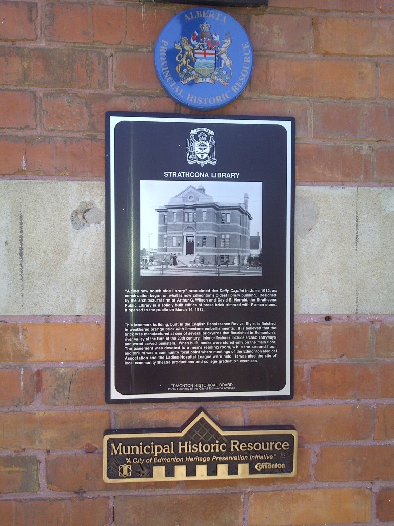
Plaques or markers are often used to identify designated historic resources. These plaques, affixed to Strathcona Public Library in Edmonton, show that it has been designated as a Provincial Historic Resource and a Municipal Historic Resource. PHRs are identified by a blue, enamel button or marker. MHRs can be identified by a variety of plaques and markers depending on the procedures of the municipality. Source: Historic Resources Management.
Editor’s note: Welcome to the sixth post in a series of blog posts developed with municipalities in mind who either have or are considering undertaking Municipal Historic Resource designation. In this post, we will introduce the concept of a “period of significance” and explain why it is important to establish as part of the designation process. You can read the previous post here.
For more information, please review the “Creating a Future” manuals available here or contact Rebecca Goodenough, Manager, Historic Places Research and Designation at rebecca.goodenough@gov.ab.ca or 780-431-2309.
Written by: Stefan Cieslik, Heritage Conservation Adviser and Rebecca Goodenough, Manager Historic Places Research and Designation
Period of Significance
Simply put, the period of significance of a historic resource is the time frame when the place acquired its significance. The heritage value section of the Statement of Significance (SOS) articulates why the place is historically significant, such as an association with an event, person, theme, institution, style of design, etc. Each of these heritage values will have an associated time frame, which informs the period of significance.
Some associations will have start and end periods while others will still have the association today. The period may be very specific if the resource is significant for a single event, or it may span hundreds of years if it is a prehistoric cultural landscape. A period of significance is specific to a site—it is not a general era of development for a community or other reference point. Where the historic place is a building, it should never predate the date of construction.
Editor’s note: Welcome to the fourth post in a series of blog posts developed with municipalities in mind who either have or are considering undertaking Municipal Historic Resource designation. In this post, we will continue to discuss Statements of Significance as the primary tool for summarizing the significance of designated historic places. You can read the previous post here.
For more information, please review the “Creating a Future” manuals available here or contact Rebecca Goodenough, Manager, Historic Places Research and Designation at rebecca.goodenough@gov.ab.ca or 780-431-2309.
Written by: Dorothy Field, Heritage Survey Coordinator, Sandy Aumonier, Heritage Conservation Adviser and Allan Rowe, Historic Places Research Officer, Historic Resources Management Branch
As previously mentioned, a Statement of Significance (SOS) is a one- to two-page summary document written as a clear, concise and brief narrative of a historic resource. It is written for a broad audience that is not familiar with the resource. The SOS has three sections: description of historic place, heritage values and character-defining elements.
An SOS is central to understanding a resource and any of its elements that might be protected and why.
If a historic resource is designated, the SOS will thereafter be an important planning and property management tool and essential for developing a conservation plan for ongoing management of the resource.
Editor’s note: Welcome to the third post in a series of blog posts developed with municipalities in mind who either have or are considering undertaking Municipal Historic Resource designation. In this post, we will introduce Statements of Significance as the primary tool for summarizing the significance of designated historic places. You can read the previous post here.
For more information, please review the “Creating a Future” manuals available here or contact Rebecca Goodenough, Manager, Historic Places Research and Designation at rebecca.goodenough@gov.ab.ca or 780-431-2309.
Written by: Peter Melnycky, Historian and Gary Chen, Heritage Conservation Adviser, Historic Resources Management Branch
A Statement of Significance (SOS) is a one or two page summary document written as a clear, concise and brief narrative of a historic resource. It is written for a broad audience that is not familiar with the resource.
The SOS is comprised of three sections:
Description of Historic Place – concisely describes the resource
Heritage Values – explains the reasons why the resource is valued
Character-Defining Elements – lists the physical elements of the resource that are central to the site`s significance, features which would be essential for preservation upon designation
An SOS is central to understanding a resource and any of its elements that might be protected and why.
If a historic resource is designated, the SOS will be an important planning and property management tool, and essential for developing a conservation plan for ongoing management of the resource.
Written by: Ron Kelland, Historic Places Research Officer
Back a few weeks ago, in the early days of COVID-19 pandemic response, I, like many Albertans, was closely watching news coverage. One news story that caught my attention was about the lines of traffic of returning Canadian travelers at the Coutts/Sweet Grass International Border Crossing. The story really jumped out at me because I had just read about novelist Charles Dickens’ involvement with the philanthropic work of Baroness Angela Burdett-Coutts. Being the geographical names guy, I was aware that the village of Coutts and the hamlet of Burdett were named for the Baroness Burdett-Coutts, so I started to think about how was it that these two communities ended up with names honouring and commemorating a Victorian-Age, aristocratic philanthropist and social reformer.
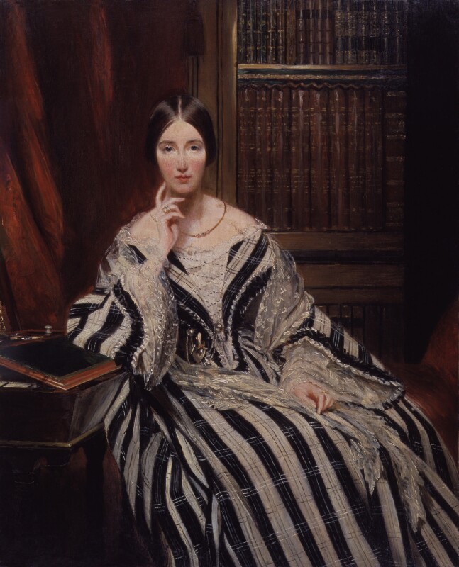
Baroness Burdett-Coutts, artist unknown, oil on panel, ca. 1840. Source: National Portrait Gallery, London, NPG 6181. Used under Creative Commons License (CC BY-NC-ND 3.0)
Angela Burdett-Coutts, the 1st Baroness Burdett-Coutts was born Angela Burdett in 1814, the daughter of radical reformist politician and anti-slavery advocate Sir Francis Burdett and Sophia Burdett (née Coutts). In 1837, upon the death of her step-grandmother, the actress Harriet Mellon, Angela inherited the entire Coutts estate of £1.8 million ($191 million in 2020 Canadian dollars) including a substantial interest in the Coutts Bank, making her the second-wealthiest woman in the United Kingdom after Queen Victoria. In accordance with the conditions of the will, Angela Burdett sought and received royal license to combine her ancestral names to become Angela Burdett-Coutts.
Over the past few months, some of Alberta’s municipalities have been protecting their built heritage by designating a number of new Municipal Historic Resources (MHRs). These resources are structures and other sites that the municipality has deemed to be of significant heritage value to their community. Like Provincial Historic Resources, municipal designations are listed on the Alberta Register of Historic Places. Municipally designated properties also qualify for conservation grants from the Alberta Historic Resources Foundation.
The City of Lethbridge recently added six new MHRs to the Alberta Register of Historic Places. As of May 31, 2019, the City of Lethbridge has 26 designated MHRs listed.
The most recent listed designations by the City of Lethbridge are:
Watson Residence
Located in the Victoria Park neighbourhood on 14th Street South between 3rd and 4th Avenue, the Watson Residence is an Edwardian Foursquare with classical revival detailing and ornamentation. It was built in 1910/11. It has heritage value as an example of residential construction during Lethbridge’s rapid expansion in the pre-First World War period, and as an excellent example of an urban foursquare home. It was also the residence of Allan James Watson, who was a long-serving superintendent of the Lethbridge School District.
Watson Residence, Lethbridge, February 2019. Source: Historic Resources Management, Government of Alberta