Written by: Fraser Shaw, Heritage Conservation Advisor
The southern Alberta horizon shimmers in the summer heat and seems limitless as one drives across southern Alberta near Brooks. Approaching the region, indistinct bands of green in the distance thicken and, like a mirage, resolve into shelterbelts and dense stands of trees. The striking, even surreal, contrast with the surrounding semi-arid prairie is the result of large-scale irrigation works of the early twentieth century financed and backed by, among others, Canadian Pacific Railway (CPR). Conceived to make “Palliser’s Triangle” fertile for agriculture and settlement, these works included the Bassano Dam, hundreds of kilometres of irrigation canals and ditches and the Brooks Aqueduct, a 3.2 km-long reinforced concrete flume. One of the largest aqueducts of its kind in the world and an engineering tour de force when built, the decommissioned aqueduct is both a Provincial Historic Resource and a National Historic Site of Canada.
Duke of Sutherland Residence or Bungalow, south facade, September 2021. Source: Historic Resources Management Branch.
At the epicentre of this transformed landscape, just outside Brooks, lies the Duke of Sutherland Site Complex, a Provincial Historic Resource comprised of a large residence, a barn and pumphouse, Delco generator building and remnants of irrigation ditches on an approximately two-hectare site. This was the administrative heart of a 2,752-hectare agricultural colony of Scottish and English settlers established in 1909 by the Fourth Duke of Sutherland of Scotland. Eager to invest in Canada and to promote irrigation and farming in the Brooks area, the Duke was a major CPR shareholder whose extensive holdings including a large ranching operation on rented CPR land.
Editor’s note: Our first article recognizing #HistoricPlacesDays takes us to southern Alberta. The banner image above, featuring low-lying rear lots with gardens in Lethbridge’s Chinatown in 1956, looking west, is courtesy of the Galt Museum and Archives.
Written by: Fraser Shaw, Heritage Conservation Advisor
Since its construction in 1924, the Chinese Free Masons Building has been an anchor in the physical and social fabric of downtown Lethbridge and on of Alberta’s most intact historic “Chinatowns”. A large crack zigzags across the west wall of the Provincial Historic Resource and propagates east down the block, telegraphing through the walls of its historic neighbours and terminating at the old No. 1 Fire Hall. The crack recently presented repair challenges and is the legacy of a historic landscape and a transformed physical and cultural geography.
1990s photograph from the northwest with the west wall crack and previous repairs clearly visible toward the back (right) half of the building. Source: Historic Resources Management Branch.
Some 12,000 years ago, as the Laurentide ice sheet retreated toward Hudson Bay, torrents of meltwater carved deep channels across southern Alberta, including today’s Oldman River valley. Long tributary coulees reached like fingers from the valley’s east side, a pattern evident today along the escarpment behind the Galt Museum. One of these coulees extended east between what is now 2nd and 3rd Avenue South and appears in early plans and photographs of Lethbridge. Uneven and difficult to build on, the block attracted Chinese immigrants and entrepreneurs who established new businesses on lots that were strategically close to the fledgling town centre but slightly apart from it, a development pattern reinforced by discriminatory policies of the day that relegated Chinese-owned businesses to marginal land away from the commercial core.
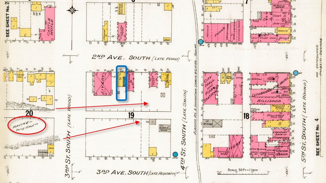
A fire insurance map of 1910 predates the construction of the Chinese Free Masons Building on Block 19 Lot 5 (blue outline) but notes infilling of the ravine or coulee (circle at lower left). Arrows indicate the original extent of the coulee eastward through Block 19. Source: Library and Archives Canada, with added annotations.
Development has infilled the coulee such that the historic landscape today survives only in the sunken rear lots of the Bow On Tong Company Building and Wing Wah Chong Company Building, both of which are Municipal and Provincial Historic Resources. These low-lying back yards were historically put to good use, providing direct access to basement apartments for newly arrived immigrants from China and serving as vegetable gardens (see banner image at top of page). Though hidden, the buried coulee survives as relatively weakly consolidated infill soil under the back portions of the block’s historic buildings. These areas move and crack as soil compacts, takes up water from the poorly drained rear lots, or moves seasonally where shallow rear foundations are susceptible to frost heave. The rear lot at the Chinese Free Masons Building has been infilled but unstable soil conditions persist and cause structural movement and recurrence of the west wall crack despite repeated patching.
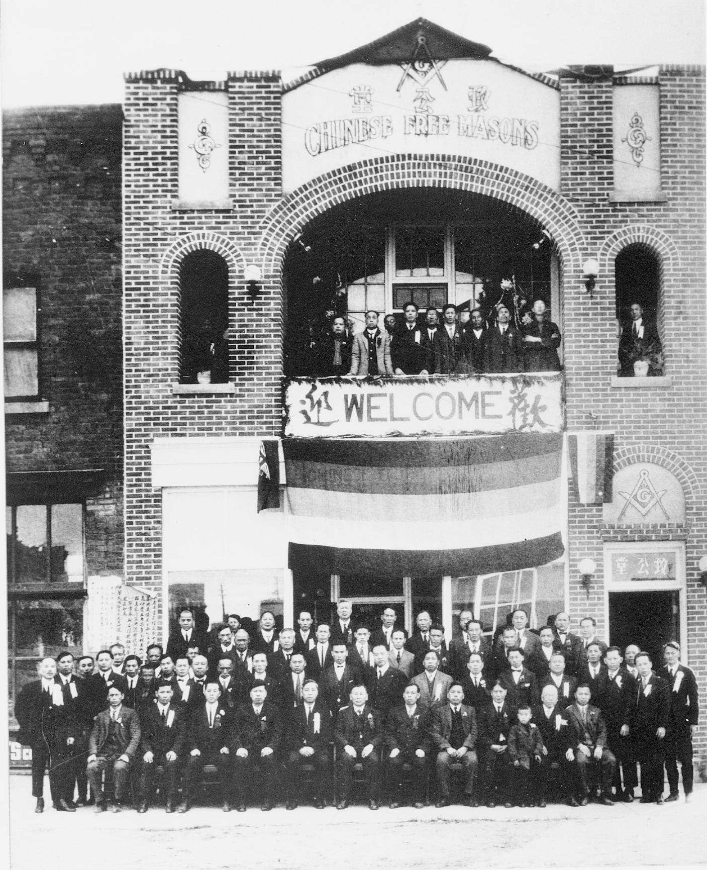
1924 photograph, possibly showing the Masonic hall’s grand opening. Source: Galt Museum and Archives photograph 19800128000.
Foundation underpinning on deep piles into undisturbed soil would stop the structural movement and cracking but is very costly. A local architect assessed no immediate threat to the building and recommended a practical and cost-effective crack repair alternative. This consisted of saw cutting a new flexible control joint into the outer wythe or layer of brick beside the old crack, to accommodate ongoing structural movement while maintaining integrity as a weather seal. The existing crack was too irregular for proper installation of a reliable sealed joint. As a precaution, the established crack was also repaired with flexible sealant, into which masonry sand was pressed to resemble a traditional mortar joint and disguise the repair as much as possible.
Conservation work normally favours traditional materials but a deep mortar repair risked “locking” the wall in place and causing cracks to appear elsewhere. Correctly formulated lime mortars can absorb some movement and even “self heal” as free lime recrystallizes within emerging hairline cracks — but structural movement at the Free Masons Building demanded a more elastic joint.
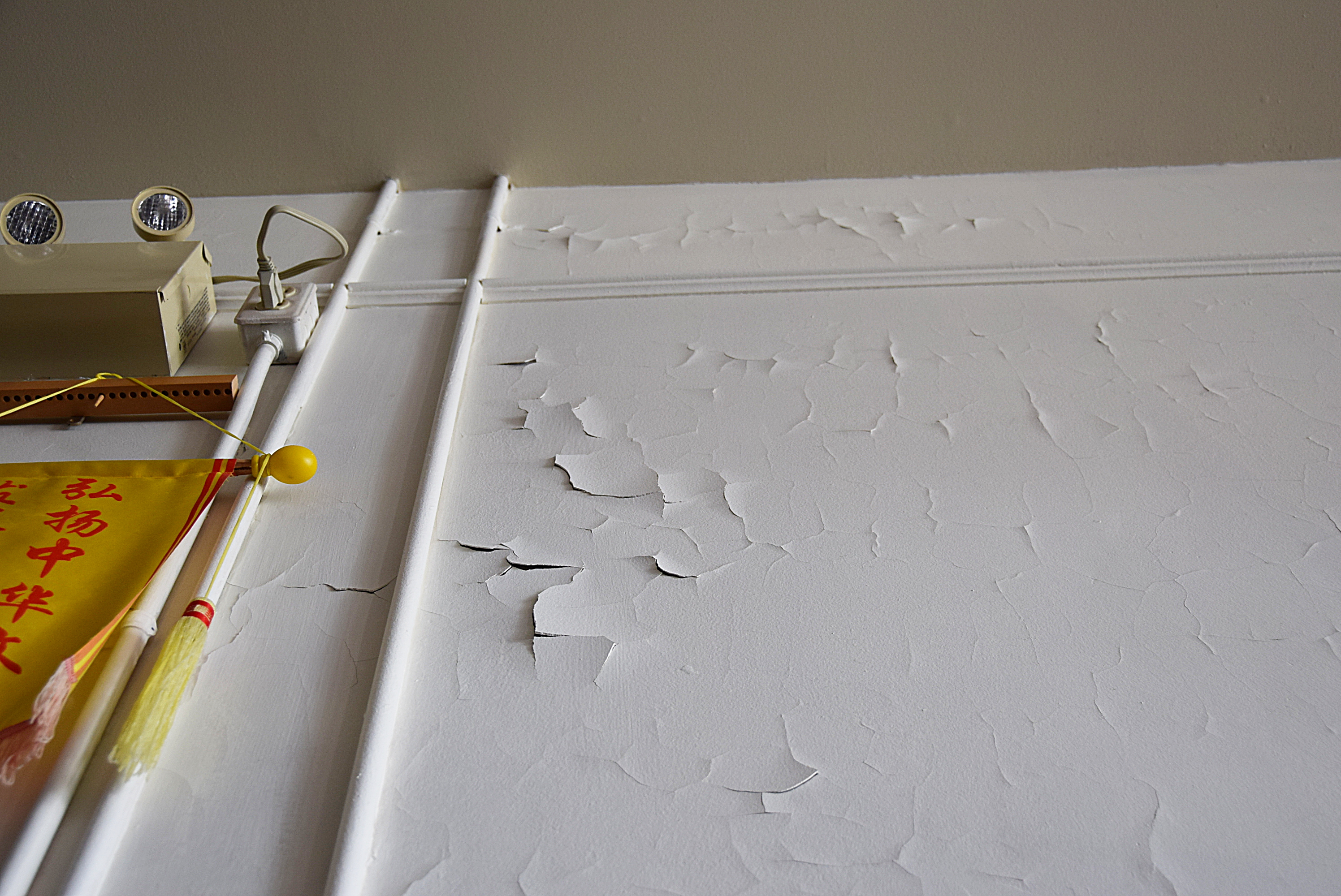
Paint failure on second floor interior west wall, April 2019. Source: Historic Resources Management Branch.
The second floor offers a large open space that has served as a Masonic hall for almost a century. The interior walls are original plaster applied to the interior face of the brick masonry exterior walls. Coated with many layers of paint, the walls deteriorated rapidly after the interior was repainted to hide smoke damage after a fire in 2009. Driving rain through the west wall crack was initially suspected as a moisture source but the extensive paint failure was actually in another location. Further assessment determined that the problem was excess moisture within the wall combined with the wall’s inability to dry through impermeable layers of paint.
The west wall is thus a highly porous brick that readily absorbs moisture. Like many old brick buildings, the Chinese Free Masons Building uses a high-quality, durable brick on the front facade with less expensive bricks on the side walls that were often intended to be protected by adjacent buildings. Mortar joints also play a role: lime mortar both binds the masonry and actively wicks moisture in the wall to the surface, where it then evaporates. However, as mortar weathers, leaching of the lime binder reduces this wicking action and eroded joints provide more surface area for water absorption, effectively turning a wall into a sponge. On the wall’s inner face, permeability declines with each layer of paint and as old alkyd paint ages. The most recent repainting was the last straw: acrylic latex paint is vapour-permeable but drying of the wall fabric relies on liquid (if microscopic) capillary moisture transfer. The result is that moisture absorbed through the exterior brick trapped within the wall literally pushes the paint off the plaster.
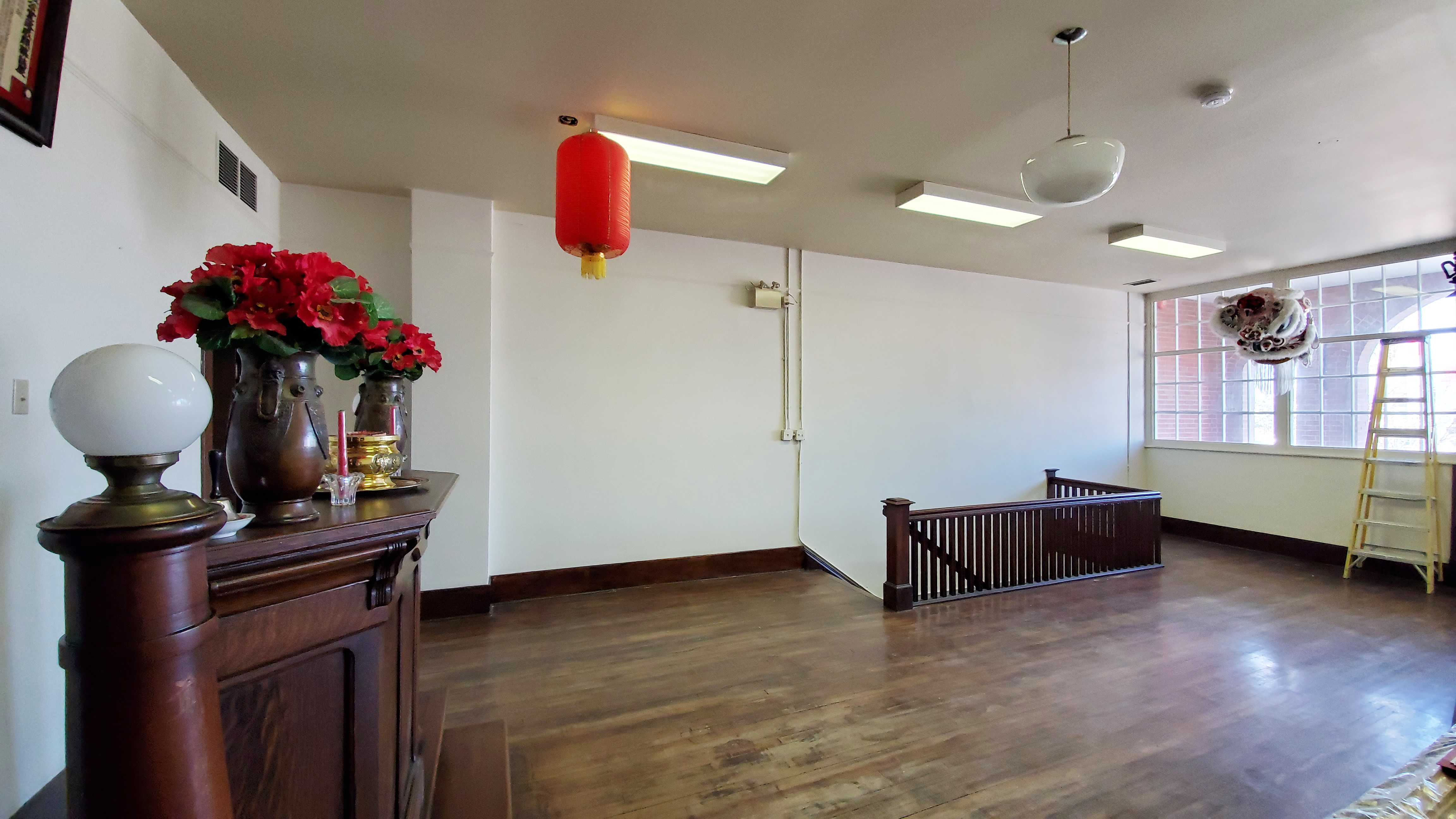
Second floor (Masonic hall) with far wall after plaster repairs and application of clay paint, March 2021. Source: Historic Resources Management Branch.
To correct the problem, peeling interior paint was stripped by hand and moisture-damaged plaster was patched with a compatible gypsum plaster free of latex or polymer additives that might otherwise impede prevent drying. A special, highly permeable clay-based paint was applied to the wall and colour-matched to the historic interior. Combined with renewing or “repointing” the exterior masonry with a compatible lime mortar, these measures avoid sealing the wall and instead restore the historic fabric’s intrinsic ability to absorb, buffer and release moisture by drying to the interior and exterior. The repaired west wall with its new control joint and evidence of the old crack are a testament to ancient landforms, local history and Lethbridge’s evolving urban landscape.
View from northwest in June 2021 with new control joint on west wall and muted expression of historic crack. Source: Historic Resources Management Branch.
Sources:
C.B. Beaty and G.S. Young, The Landscapes of Southern Alberta: A Regional Geomorphology (Lethbridge: University of Lethbridge, 1975), 66-77.
For a discussion of the early development of Lethbridge’s Chinatown, see David Chuenyan Lai, Chinatowns: Towns Within Cities in Canada (Vancouver: University of British Columbia Press, 1988), 90-91.
Written by: Fraser Shaw, Heritage Conservation Advisor
Recently, I visited the Maccoy Homestead in High River after seven long years of flood repairs and conservation. Nestled in Sheppard Family Park near the south edge of High River, this was the farm and home of well-known local resident Ruth Maccoy for over 70 years. Upon her passing in 1995 and at her bequest, the farm became Sheppard Family Park with the homestead as its nucleus.
The home is a charming 1883 whitewashed log building, the earliest structure on the site, with a frame addition and porch built by her parents in the 1920s and surrounded by a garden and picket fence lovingly tended by Ruth Maccoy over the years. Behind the house are a garden shed, a small guesthouse, and a root cellar set into an embankment, while the garage is located nearby. A path leads west through the trees to a footbridge over the Little Bow River, usually a shallow creek, to the historic water source in a natural spring.
One of High River’s first municipal designations, the Sheppard/Maccoy House was designated as a Municipal Historic Resource in 2009 by the Town of High River for its association with Ruth Maccoy and early settlement in the area. An exceptional example of an early farm, the site also exemplifies the contribution of women’s labour to homesteading and agriculture in rural Alberta and was designated a Provincial Historic Resource in 2015. The site is a good example of how complementary municipal and provincial heritage values tell a richer story and was the subject of a RETROactive post earlier this summer.
Editor’s note: You can read more of Fraser Shaw’s series on heritage conservation on RETROactive.
Written by: Fraser Shaw, Heritage Conservation Advisor
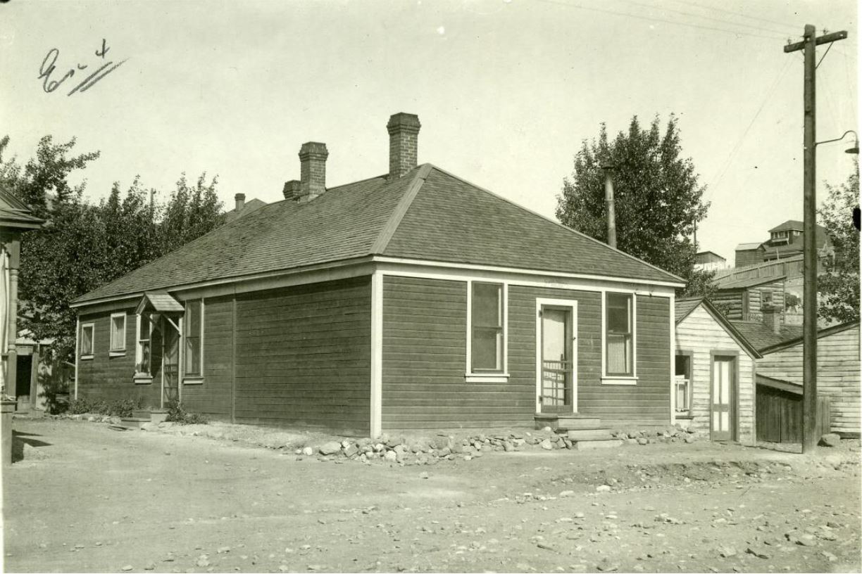
Gunshots shattered the stillness of 18 Avenue in Coleman on the afternoon of September 21, 1922.
Local bootlegger Emilio Picariello and his accomplice Florence Lassandro sped off in a cloud of dust as Constable Stephen Lawson lay dead outside the Alberta Provincial Police barracks, a cottage-like office and residence where he worked and resided with his family. Hours later, “Emperor Pic”—as he was known locally—and Lassandro were apprehended and charged with Lawson’s murder. Both were later convicted and hanged. Lassandro became the first woman to be executed in Canada since 1899 and the only woman to be hanged in Alberta.
The Alberta Provincial Police Building as it appeared in late 1922 after the murder of Constable Stephen Lawson. Source: Crowsnest Museum.
The Alberta Provincial Police (APP) Building, a Provincial Historic Resource within the Coleman National Historic Site, is significant for its association with the infamous murder of Constable Lawson and, more generally, with its role in the maintenance of law and order in the mining communities of the Crowsnest Pass during Prohibition until the 1930s.
Editor’s note: If you’re interested in other restoration projects by the government’s Heritage Conservation Advisers, read about the conservation of Circle L Ranch.
Written by:Fraser Shaw, Heritage Conservation Adviser
Designated a Provincial Historic Resource in 2013, the Taber Courthouse presides over a quiet park just off Taber’s main street. The building’s stately arched entryway speaks to its historic importance as one of Alberta’s first “sub-jurisdiction” courthouses, a system of provincial justice administration introduced at the time.
Built in 1918, Assistant Provincial Architect J.B. Allan developed the courthouse design and noted Provincial Architect Richard P. Blakey subsequently revised it. Blakey’s eclectic mix of Edwardian, Classical Revival and Spanish Colonial Revival elements eventually became an architectural prototype for other courthouses of the period. Examples of Blakey’s work that are still intact include the Blairmore Courthouse in the Crowsnest Pass and the Medicine Hat Courthouse. Both of these buildings are Provincial Historic Resources.