Written by: Colleen Haukaas, Archaeological Survey
In April the Historic Resources Management Branch (HRMB) released the Spring 2021 Edition of the Listing of Historic Resources. The Listing is a biannual release of lands in Alberta that are known to contain or are likely to contain lands of a sensitive historic nature. Land parcels used in the Listing are Legal Subdivisions in the Alberta Township Survey system. The Listing is generated as a tool to aid developers, land agents, planners and other stakeholders when planning land-based development projects in Alberta.
Each land parcel in the Listing is assigned a Historic Resource Value (HRV) ranging from 1 to 5:
Historic Resource Value (HRV)
Description
HRV 1
contains a World Heritage site or a site designated under the Historical Resources Act as a Provincial Historic Resource
HRV 2
deactivated (formerly used to designate a Registered Historic Resource)1
HRV 3
contains a significant historic resource that will likely require avoidance
HRV 4
contains a historic resource that may require avoidance
Each entry is also assigned a category of the primary historic resource category of concern:
Category
Description
a
archaeological
c
cultural
gl
geological
h
historic period
n
natural
p
palaeontological
Sample map of the Listing of Historic Resources at Edmonton. Map was generated with the online Listing webmap.
A legal subdivision can have more than one HRV rating or category. For example, a legal subdivision that contains both an archaeological site and an area of high palaeontological potential may be classified as 4a, 5p.
The Listing is generated by gathering information from consultants and researchers working in archaeology, palaeontology, history and other industries in Alberta, and comparing their findings with known resources at the HRMB. Our staff use GeographicInformation Science software to compile and generate the Listing.
To view the new version of the Listing, see the online webmap version here. For more details or for information for developers, see our website.
Editor’s note: Welcome to the final post in a series of blog posts developed with municipalities in mind who either have or are considering undertaking Municipal Historic Resource designation. In this post, we will discuss how the evaluation of a historic resource at the provincial and municipal level may result in complimentary or differing heritage values. You can read the previous post here.
For more information, please review the “Creating a Future” manuals available here or contact Rebecca Goodenough, Manager, Historic Places Research and Designation at rebecca.goodenough@gov.ab.ca or 780-431-2309.
Written by: Fraser Shaw, Heritage Conservation Adviser and Ron Kelland, Historic Places Research Officer, Historic Resources Management Branch
Complementary and differing values
Alberta’s Historical Resources Act empowers both the Government of Alberta and municipalities to designate, or recognize and protect, a range of historic resources whose preservation is in the public interest. These resources can be places, structures or objects that may be works of nature or people (or both) that are of palaeontological, archaeological, prehistoric, historic, cultural, natural, scientific or aesthetic interest. Albertans value these historic resources because our past, in its many forms, is part of who we are as a society and helps give our present significance and purpose.
As of July 2020, there are currently 390 Provincial Historic Resources (PHR) and 413 Municipal Historic Resources (MHR) in Alberta, some 60 of which are designated both provincially and municipally. These resources merit designation for various reasons, from their association with significant events, activities, people or institutions; as representative examples of architectural styles or construction methods; for their symbolic and landmark value; or their potential to yield information of scientific value.
Heritage values are described in short Statements of Significance, which are listed on the Alberta Register of Historic Places. In this post, we look at examples of heritage values that municipal and provincial governments recognize and how local and provincial values may align, differ or complement each other.
Plaques or markers are often used to identify designated historic resources. These plaques, affixed to Strathcona Public Library in Edmonton, show that it has been designated as a Provincial Historic Resource and a Municipal Historic Resource. PHRs are identified by a blue, enamel button or marker. MHRs can be identified by a variety of plaques and markers depending on the procedures of the municipality. Source: Historic Resources Management.
Editor’s note: Welcome to the fourth post in a series of blog posts developed with municipalities in mind who either have or are considering undertaking Municipal Historic Resource designation. In this post, we will continue to discuss Statements of Significance as the primary tool for summarizing the significance of designated historic places. You can read the previous post here.
For more information, please review the “Creating a Future” manuals available here or contact Rebecca Goodenough, Manager, Historic Places Research and Designation at rebecca.goodenough@gov.ab.ca or 780-431-2309.
Written by: Dorothy Field, Heritage Survey Coordinator, Sandy Aumonier, Heritage Conservation Adviser and Allan Rowe, Historic Places Research Officer, Historic Resources Management Branch
As previously mentioned, a Statement of Significance (SOS) is a one- to two-page summary document written as a clear, concise and brief narrative of a historic resource. It is written for a broad audience that is not familiar with the resource. The SOS has three sections: description of historic place, heritage values and character-defining elements.
An SOS is central to understanding a resource and any of its elements that might be protected and why.
If a historic resource is designated, the SOS will thereafter be an important planning and property management tool and essential for developing a conservation plan for ongoing management of the resource.
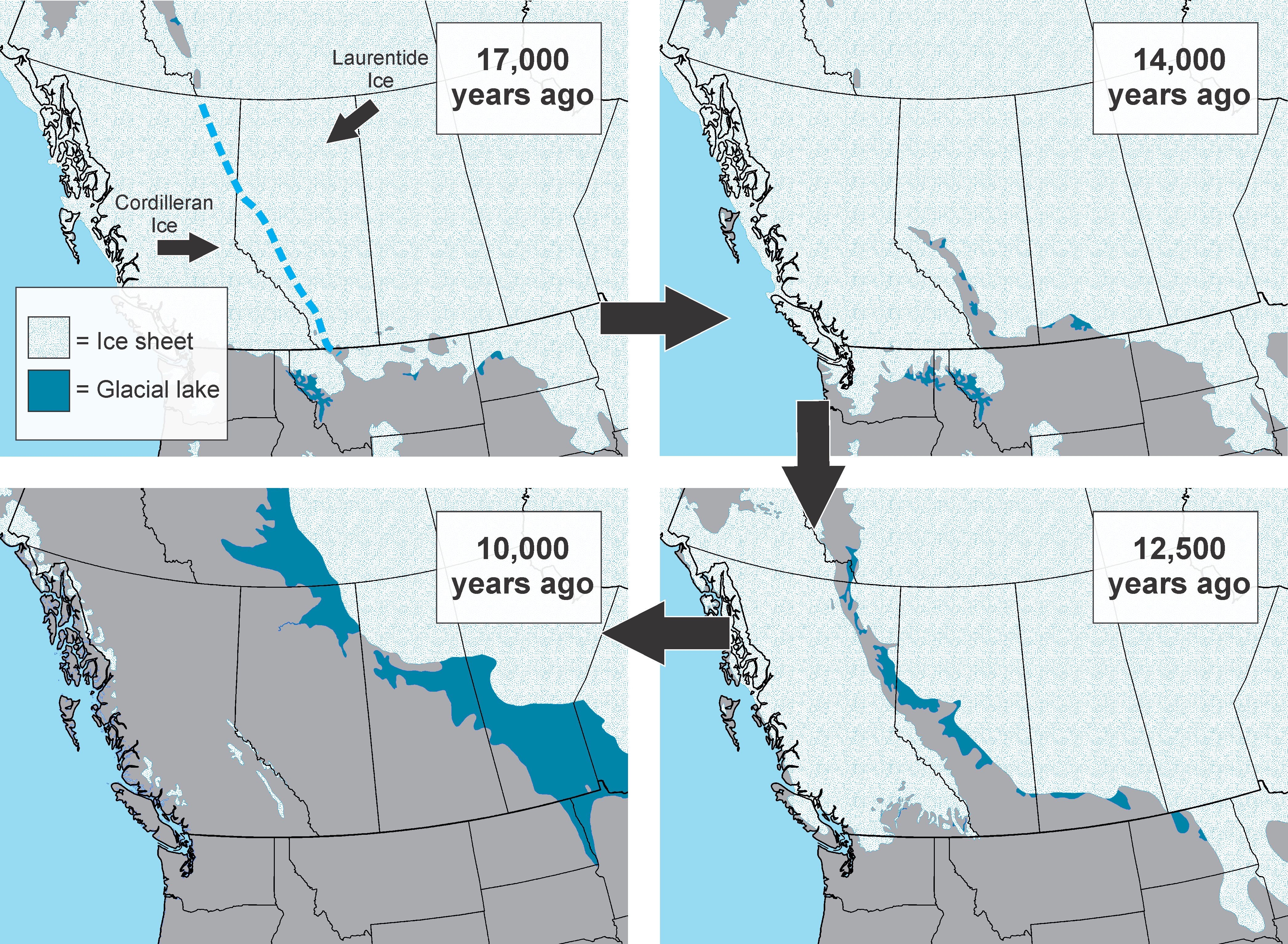
Editor’s note: This is part one of a two part series on the history of human relationships with trees in Alberta. Next week’s post will discuss the development of the forestry industry, modern research and the Heritage Art Series.
Written by: Todd Kristensen, Archaeological Survey of Alberta
People in Alberta have relied on trees since these woody plants colonized our ice-scraped province around 11,000 years ago. Millions of collective hours were spent by people gathering and chopping wood for warmth and cooking, but our relationship with trees runs much deeper than heat. People in Alberta have relied on them to build tools, homes, and transportation networks, and our forestry industry continues to shape the province.
Logging at Poplar Creek, Alberta in the late 1800s. Image A5085 courtesy of the Provincial Archives of Alberta.
What Trees Grow Here and Why?
Much of the prairies are too hot and dry for forests, but most of central and northern Alberta have ideal temperatures and moisture levels for trees: over 60% of the province is covered by forests. While our precipitation helps trees grow, Alberta is dry enough (over long enough periods in the summers) to be fire-prone. Most natural forests here rarely exist for more than 100 years before a fire re-starts the growth of a series of plant communities (called ‘succession’). Our ‘pyrogenic’ forests are younger and typically smaller than neighbours to the west where heavier rains and different soils produce massive old growth forests that often exceed 600 years old.
Written by: Sara King, Government Records Archivist, Provincial Archives of Alberta
Its film time again courtesy of the Provincial Archives of Alberta! Archival records, whether paper, photographic, film or audio, can very often provide more information about their subject than was originally intended.
Take It Happened at Vic. This silent drama production about a love triangle, created by Victoria Composite High School students in Edmonton in 1941, reveals how the school and neighbourhood looked at the time, hair and fashions typical of high school students, technology they were using such as cameras and cars, and the types of social activities that students might have been getting up to at the time (Or at the least the ones they would put on film). If the name Joe Shoctor jumps out at you from the opening credits, he went on to found the Citadel Theatre in Edmonton.
Written by: Emily Moffat, Regulatory Approvals Coordinator, Archaeological Survey of Alberta
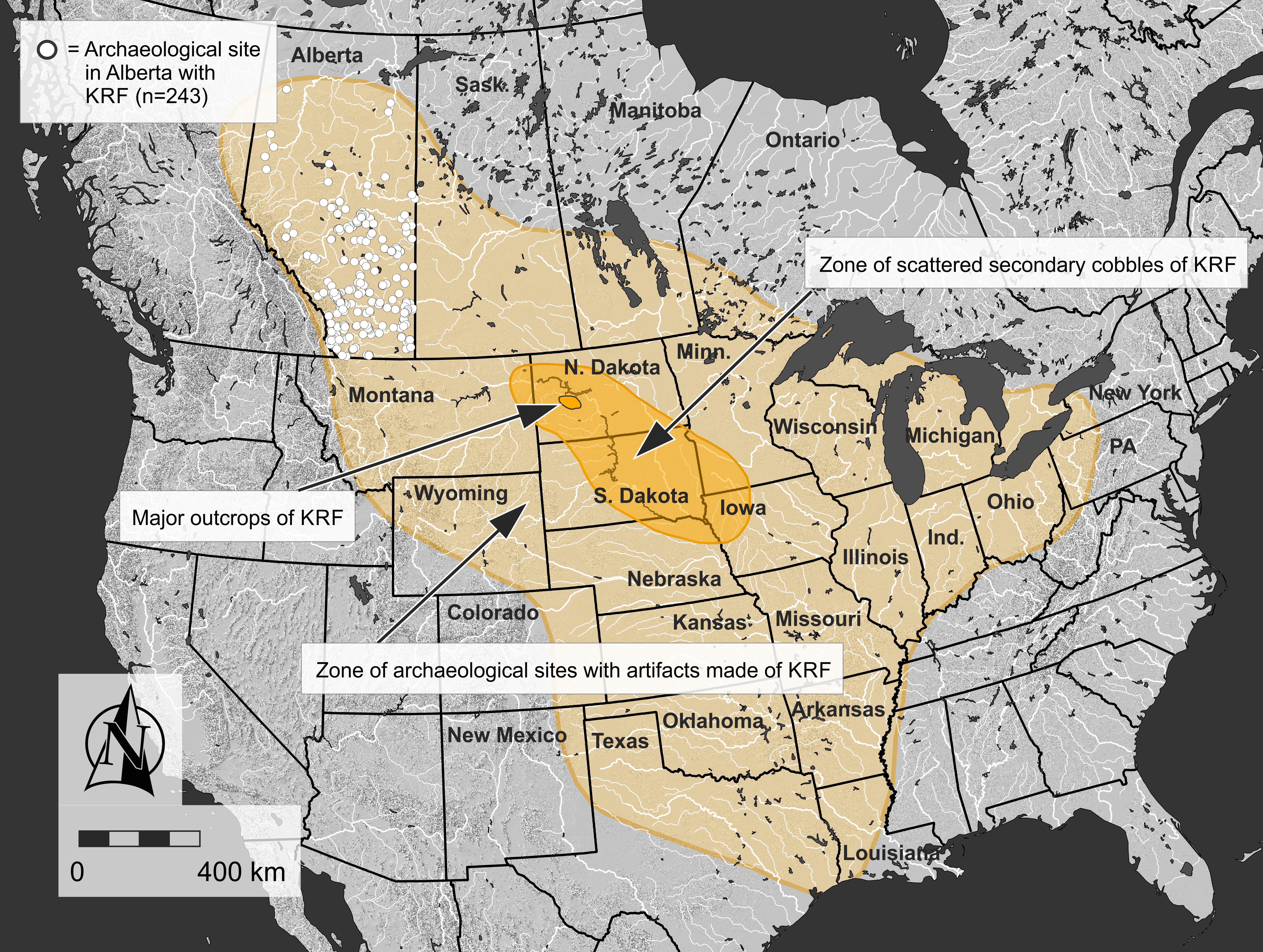
Stone tools were central to life in pre-contact North America and the rocks that they were made of were highly valued. The archaeological record throughout vast regions of North America, including much of Alberta, contains Knife River Flint (KRF), one of the most significant and intriguing tool stones used before the arrival of Europeans. KRF gets its name from the Knife River, a tributary of the Missouri River that flows through the United States Midwest and Southeast Regions.
In an era of limited human mobility compared to modern times, KRF was regularly transported hundreds of kilometres from its source in North Dakota, where it was quarried for thousands of years. A relatively small geographical region contains the majority of quarry pits and this location is the hub of KRF’s widespread distribution.
Map showing the major source area where Knife River Flint was quarried, the area where scattered cobbles were collected, and the overall extent of Knife River Flint artifacts based on published records. White circles show the extent of archaeological sites in Alberta that have produced a Knife River Flint artifact (Source: Todd Kristensen).
Written by: Ken Favrholdt, BA, MA (Geography, UBC)
Much is written about the Whoop-Up Trail, the famous 320 kilometre route from Fort Benton, Montana to Fort Macleod used by whisky traders between 1869 and 1874.
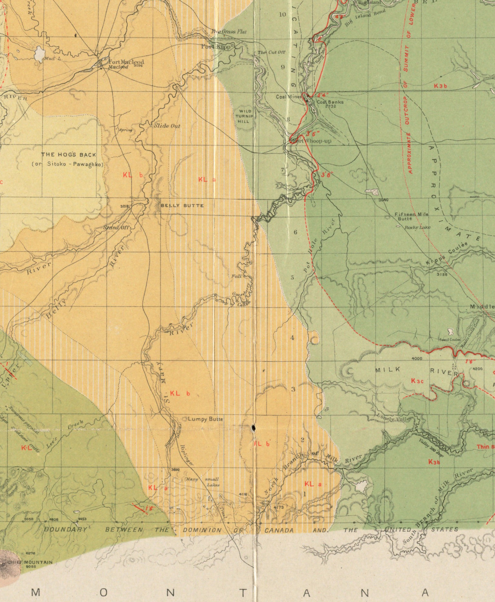
However, there was also another important route used during this period. The Riplinger Trail was an Indigenous trail across traditional Blackfoot territory and home of the Blood tribe. Part of the trail in Montana it is believed, was part of the Old North Trail, the ancient migration route—the so-called ice-free corridor—along the Front Range of the Rocky Mountains. The Riplinger Trail was named after John Riplinger of the Northwestern Fur Company who built a post on the Marias River in Montana in 1869-70.
Part of the geological map of the region in the vicinity of the Bow and Belly Rivers, by George Dawson, 1884, showing the Riplinger Trail between Fort Macleod and the 49th parallel. Source: collections.leventhalmap.org.
Stone tools and debitage, also known as lithics, are one of the most common types of artifacts found in Alberta. In the past, stone tools were an essential part of Indigenous ways of life. These stone tools and associated debitage (pieces flaked off while the stone tool was being manufactured) are made from a variety of stone types, but generally they need to be produced from quality raw materials. The characteristics of a quality raw material for making stone tools include stones that are finer-grained, somewhat brittle and uniform in texture and structure, and have few or no inclusions because these might make the rock break in unpredictable ways. Some of the highest quality material that was used in Alberta in the past comes from other places around North America, such as Knife River Flint from North Dakota, obsidian from British Columbia and the northwestern United States, and other types of cherts, argillites and other materials from neighboring provinces and states. However, several material types are available locally. Some of the most common types available in Alberta include quartzites, siltstones, cherts and petrified wood. In East Central Alberta, a common type of rock utilized by Indigenous groups in the past was pebble chert. There are areas where this stone is readily available and it can be high enough quality to be knapped into tools. While these pebble cherts can sometimes be found today in road cuts or blowouts all across East Central Alberta, there are two pre-contact quarries and associated archaeological sites near Consort, AB where large concentrations of these materials were found, collected and utilized. At these sites, there is evidence that Indigenous groups used rounded and fist-sized pebbles of chert to make stone tools.
The Misty Hills quarry site and complex (Borden block EkOp) is unique because it has large densities of both high quality chert and quartzite pebbles found in more than 130 blowouts across the site. In addition to the raw pebbles, there are many associated quarry Read more →
Written by: Darrin Hagen, legendary playwright, actor, sound designer, composer, performer, director and TV host based in Edmonton
In the tumultuous year of 1969, Canadian queers suddenly found themselves in a new legal landscape. The bill that decriminalized homosexuality passed the parliamentary vote in May – in August, that bill was voted into law. No one was quite sure what it would mean as far as day-to-day life for gays and lesbians, but some forward-thinking folks in Edmonton decided that with this new legal reality, it was time to create Edmonton’s first official queer gathering place.
They chose the name Club 70, even though it was autumn of 1969. Not only was 1969 almost over, but a few of them felt that naming it Club 69 was just a bit too cheeky. And so they heralded the approaching decade by naming the bar with an eye to a new future.
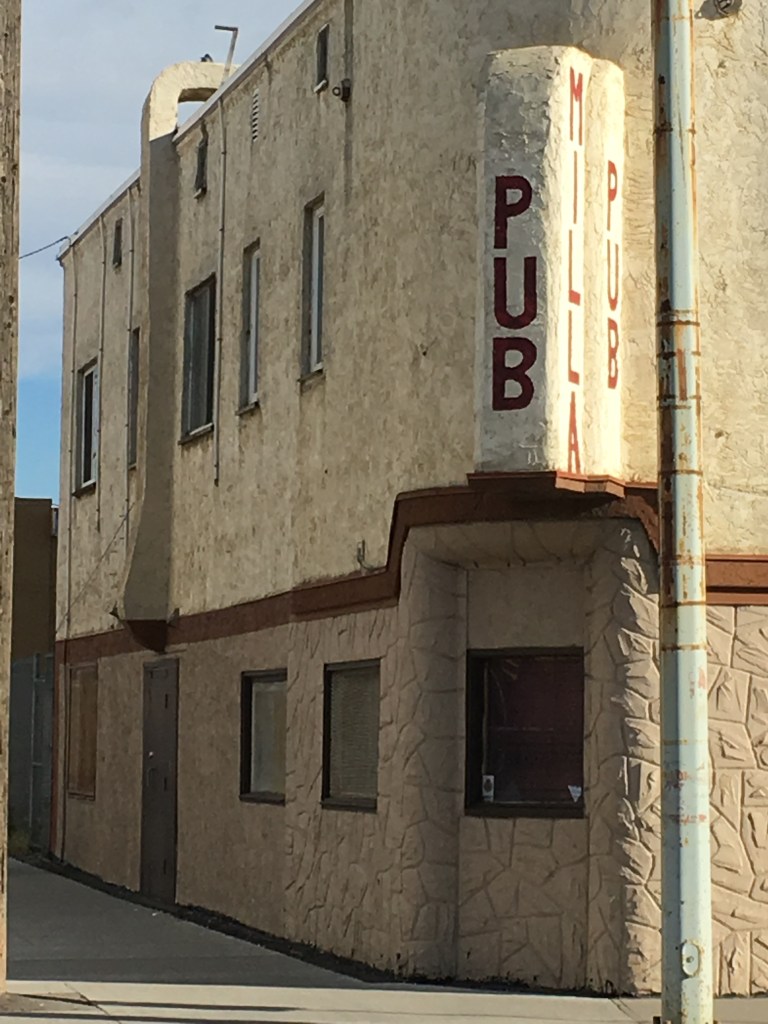
The location was on 101 street and 106 avenue, in the basement of a building that still stands today. Back then, a Greek restaurant occupied the main floor. Even though the Milla Pub is still open, the building is grubby and the yellowing plaster shows neglect. But if you look at the north end of the building, there is a brightly painted door that leads to the basement. It was behind that door that a queer person would nervously descend down the stairs into the very beginnings of Edmonton’s very first official gay club.
You may know it now as the seedy Milla Pub. But behind these doors in 1969, a queer person would nervously descend down the stairs into the very beginnings of Edmonton’s very first official gay club, Club 70.
There had always been places where the Friends of Dorothy could discretely congregate – generally in one corner of the taverns that occupied the main floor of the large, grand hotels that dominated downtown: The Mayfair, The Corona, The Royal George, and the King Edward (or King Eddie). But these gay hangouts were never official – they just sprung up out of necessity in cities across Canada. It was in these early unofficial gathering places that ‘the community’ began to recognize each other in the smoky half-light, and began to connect and communicate. Even as recently as the early 80s, a gay man could stroll into one of these smoky taverns, and once his eyes adjusted to the darkness, he could find a group of men like him, taking over one corner or certain tables in the room.
None of these hotels stand today – they’ve been replaced by downtown malls, or newer high-rises. Only the Corona LRT station keeps one of those names alive. But somehow the early gay club scene’s first legal footprint has escaped the wrecking ball of progress.
Through those nondescript doors, one descended down a flight of stairs into a space no bigger than a large living room. Everyone had to sign in, although pseudonyms were the norm – people were still very afraid to be ‘outed’ and the last thing one would want was to be identified by logging into a register of a gay bar. There was hired security – a straight man who kept a scowling presence at the bottom of the stairs.
Small stage for burgeoning drag scene
The club had no liquor license, and so bringing your own bottle was essential, as the concession only sold pop and chips. There was a small dance floor, and even a tiny stage populated by the pioneers of Edmonton’s burgeoning drag scene: Grindl performed on that stage, as did Trixie, and Millie – names that, within a few years, would become legend on the stages of the underground. Few Queens were as legendary as Millie, who in 1976 would become Edmonton’s first crowned head of state, the unofficial Godmother to all Queens who followed: Empress I of Edmonton, establishing the Imperial House of Millicent, the first in a long chapter of royal houses that still rules Edmonton through the auspices of the Imperial Sovereign Court of the Wild Rose; she was simultaneously crowned Mz. Flashback I. Millie has the distinction of being the only drag queen in Edmonton’s history who wore both crowns at the same time.
The tiny club could only hold about 50 people, and was only open on Friday and Saturday nights. The ambiance was more like a house party than a nightclub. But it was the first queer space. That meant safety. It meant being able to freely recognize and acknowledge people like yourself, to dance with whoever you wanted to dance with, or to freely cheer on a drag show.
That freedom was fiercely protected, however. Club 70 had a strict gay-only membership policy, for the safety and discretion of its members. Violating this policy by bringing a straight person to the bar would get you a 30-day suspension.
Club 70 bears the distinction of being the first official, registered-on-paper-with-city-hall, gay society in Alberta
However, it got off to a very rocky start. The location was short-lived, even though Club 70 was not. After a month of weekends of business, the owner of the building finally realized what sort of business had taken root in his basement, and when staff and members arrived for the weekend party, they found he had nailed the doors shut, seized the liquor, and whatever there was in the way of a sound system. The fledgling gay club was suddenly in a legal battle with a landlord. However, they won that battle, as their lease had been broken illegally, and were able to not only get their stuff back, but the owner of the building was forced to pay for their relocation costs.
Club 70 closed for a month, eventually finding a new home on 106 street; that building remained queer for the next 42 years. When Club 70 had run its course, it transformed into The Cha Cha Palace for a short period in 1978, then Boots & Saddles for decades, and lastly The Junction Bar & Grill. Once the 106 street location opened, that spot in Edmonton was a safe queer space from 1970-2012.
In 1969, the first step towards building a new sense of community was building a home; a meeting place or a town square, where LGBTQI people could gather, and for the first time, discover who they were in this brave but unknown new world.
Winner of the 2018 Alberta Historical Resources Foundation 2018 Heritage Awareness award, We Are the Roots is a documentary that tells the stories of African American immigrants who settled in Alberta and Saskatchewan in the early 1900s.
In the film, you’ll hear stories from 19 descendants of original settlers, as they moved north to escape slavery, persecution and racism in America. Once in Canada, these families would then experience more discrimination, both in Edmonton and in rural communities they settled.
The film was produced and created through a partnership between documentary film production company Bailey and Soda Films along with Edmonton’s Shiloh Centre for Multicultural Roots,
Click the image above to view the full-length documentary.


