Editor’s note: Special thanks to Aaron Domes (Alberta Parks), Jack Brink (retired Curator of Archaeology at the Royal Alberta Museum) and Martin Heavy Head (Elder and cultural leader of the Kainai) for their input and reviewof this article.
Written by: Todd Kristensen, Archaeological Survey of Alberta and Terra Lekach, freelance archaeologist and artist
A muddy ribbon of water flows through southern Alberta on its way to the Missouri. Along the Milk River lies 3,000 years of beliefs etched and painted as rock art on sandstone walls. An 18 km stretch of the river meanders through 149 archaeological sites displaying several thousand individual rock art images. The art documents millennia of spiritual connections to a sacred landscape and centuries of cultural change during European settlement on the Great Plains.
Writing-on-Stone/Áísínai’pi UNESCO World Heritage Site is on the Milk River in southern Alberta. Image created by Todd Kristensen.
Over 60 per cent of rock art in Alberta is found in Writing-on-Stone/Áísínai’pi and over 8 per cent of Indigenous rock art in Canada is found along this small stretch of the Milk River. Image created by Todd Kristensen, with input from 13 heritage managers across Canada.Read more →
Editor’s note: This is part two of a two-part series on the history of human relationships with trees in Alberta. If you missed part one, read it now.
Written by: Todd Kristensen, Archaeological Survey of Alberta
Development of Alberta’s Forestry Industry
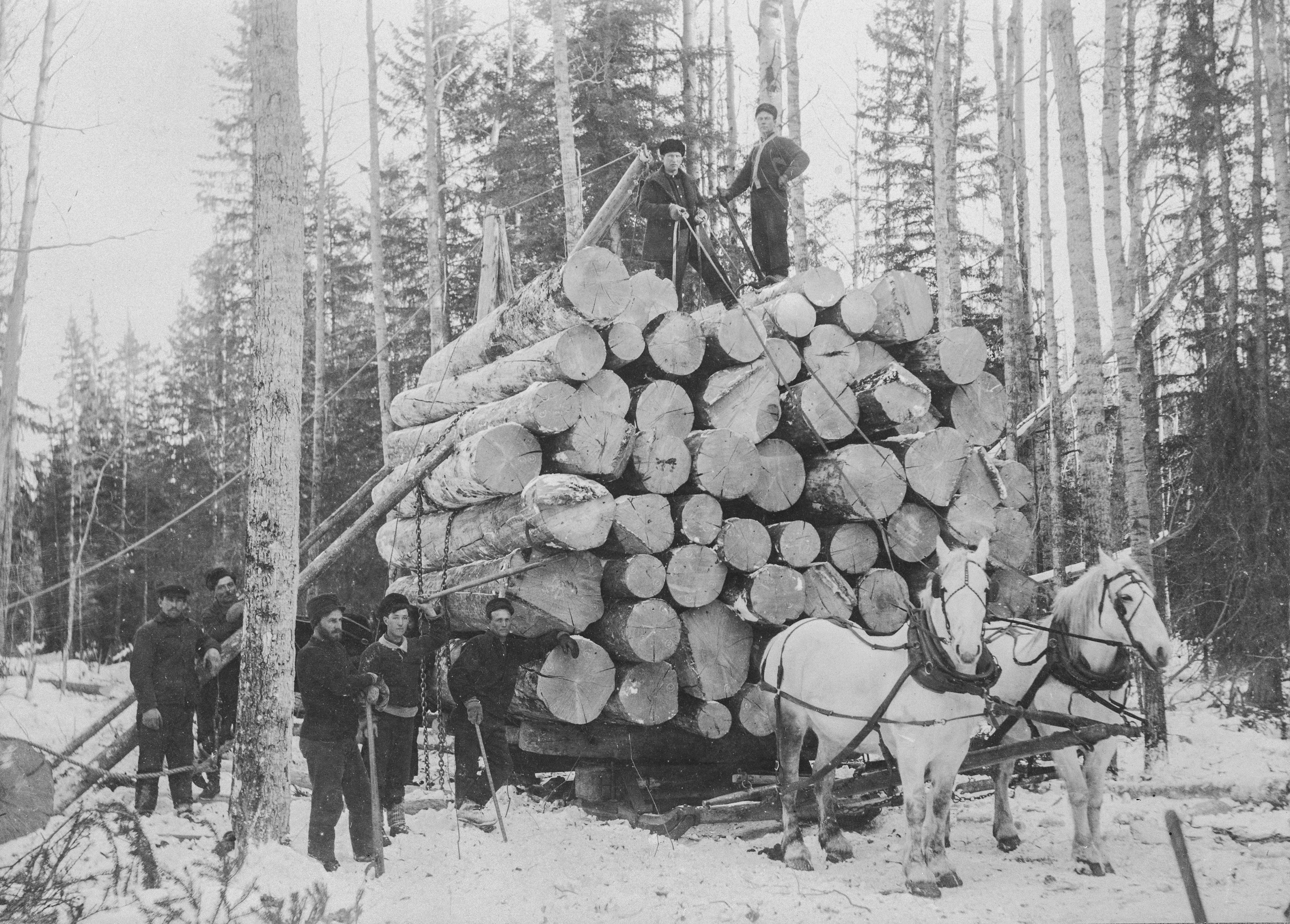
From 1900 to 1910, population growth and steady local demand for lumber meant that most settlements had commercial sawmills. Because of the way that timber berths were leased to operators, most sawmills were small and portable. Some operators harvested in the summer and moved their timber using rivers, flumes (a series of wooden chutes that filled with water and carried logs), splash dams (a temporary wooden dam that held back water that would then be released in a surge to carry logs), and log drives along big rivers that brought wood to riverside mills or to rail yards in river valleys. But winter was generally the ideal time to log because wood could be moved by horses and sleds. Portable sawmills would move machinery on skis to temporary camps in western and northern Alberta. The seasonal nature was perfect for struggling families because farmers could work the fields in warm seasons and cut timber for mills in the winters.
A man poling down Athabasca River between 1937-39 (from the Chisholm Sawmill and Freeman River Lumber Camp). Log drivers floated along with the timbers to dislodge jams and notify the mills when shipments were arriving by water. Image A3790 courtesy of the Provincial Archives of Alberta.
A logging camp (the Jackpine Wood Camp on Little Slave River in 1909) with men and their tools. Image A2532 courtesy of the Provincial Archives of Alberta.
Alberta’s forestry industry was younger than in British Columbia and neighbouring states to the south, many of which had various gold rushes that required commercial sawmills in the 1800s. It was fairly common for Alberta farmers to log in B.C. during winters in the early 1900s and many Alberta ranches provided B.C. logging operations with horses. A good-sized sawmill in B.C. or Alberta could employ several hundred men and up to 60 horses over the winter.
Editor’s note: This is part one of a two part series on the history of human relationships with trees in Alberta. Next week’s post will discuss the development of the forestry industry, modern research and the Heritage Art Series.
Written by: Todd Kristensen, Archaeological Survey of Alberta
People in Alberta have relied on trees since these woody plants colonized our ice-scraped province around 11,000 years ago. Millions of collective hours were spent by people gathering and chopping wood for warmth and cooking, but our relationship with trees runs much deeper than heat. People in Alberta have relied on them to build tools, homes, and transportation networks, and our forestry industry continues to shape the province.
Logging at Poplar Creek, Alberta in the late 1800s. Image A5085 courtesy of the Provincial Archives of Alberta.
What Trees Grow Here and Why?
Much of the prairies are too hot and dry for forests, but most of central and northern Alberta have ideal temperatures and moisture levels for trees: over 60% of the province is covered by forests. While our precipitation helps trees grow, Alberta is dry enough (over long enough periods in the summers) to be fire-prone. Most natural forests here rarely exist for more than 100 years before a fire re-starts the growth of a series of plant communities (called ‘succession’). Our ‘pyrogenic’ forests are younger and typically smaller than neighbours to the west where heavier rains and different soils produce massive old growth forests that often exceed 600 years old.
Editor’s note: All images in the post below were sourced from a report developed by the Archaeological Survey, Lifeways and Stantec.
Written by: Matthew Wangler, Executive Director, Historic Resources Management Branch
For decades, northeastern Alberta has been home to large-scale industrial activity in the region’s massive petroleum deposits. A remarkable discovery in the midst of the oil sands revealed that the same area of the province also accommodated another significant industry in ancient times; that historic and contemporary land use share a common origin in an epic event that profoundly shaped our province’s past. This blog post will explore how historic resource management in Alberta helped reveal a lost chapter of our province’s history, how the discovery illuminated both the remarkable richness and depth of the Alberta story, and the surprising connections between past and present.
Written by: Krista M. Gilliland, Western Heritage and Todd Kristensen, Archaeological Survey of Alberta
The Archaeological Survey of Alberta is proud to kick-off Occasional Paper Series No. 39 with its first two articles available for free. As with the previous volume, individual articles in the Occasional Paper Series are published online throughout the year, with the final, compiled volume released at the end of the year. We encourage submissions from archaeologists in cultural resource management (CRM), universities, and other heritage professions.
Submissions to Occasional Paper No. 39, edited by Krista M. Gilliland, are welcome.
Occasional Paper Series No. 39, “Advancing archaeology: Industry and practice in Alberta, 2019,” is dedicated to an influential member of the archaeological community in Western Canada, Terry Gibson, who passed away in 2018. The first article in the volume is a tribute to him.
Terry Gibson (1954-2018) played an important role shaping the CRM community in Western Canada.
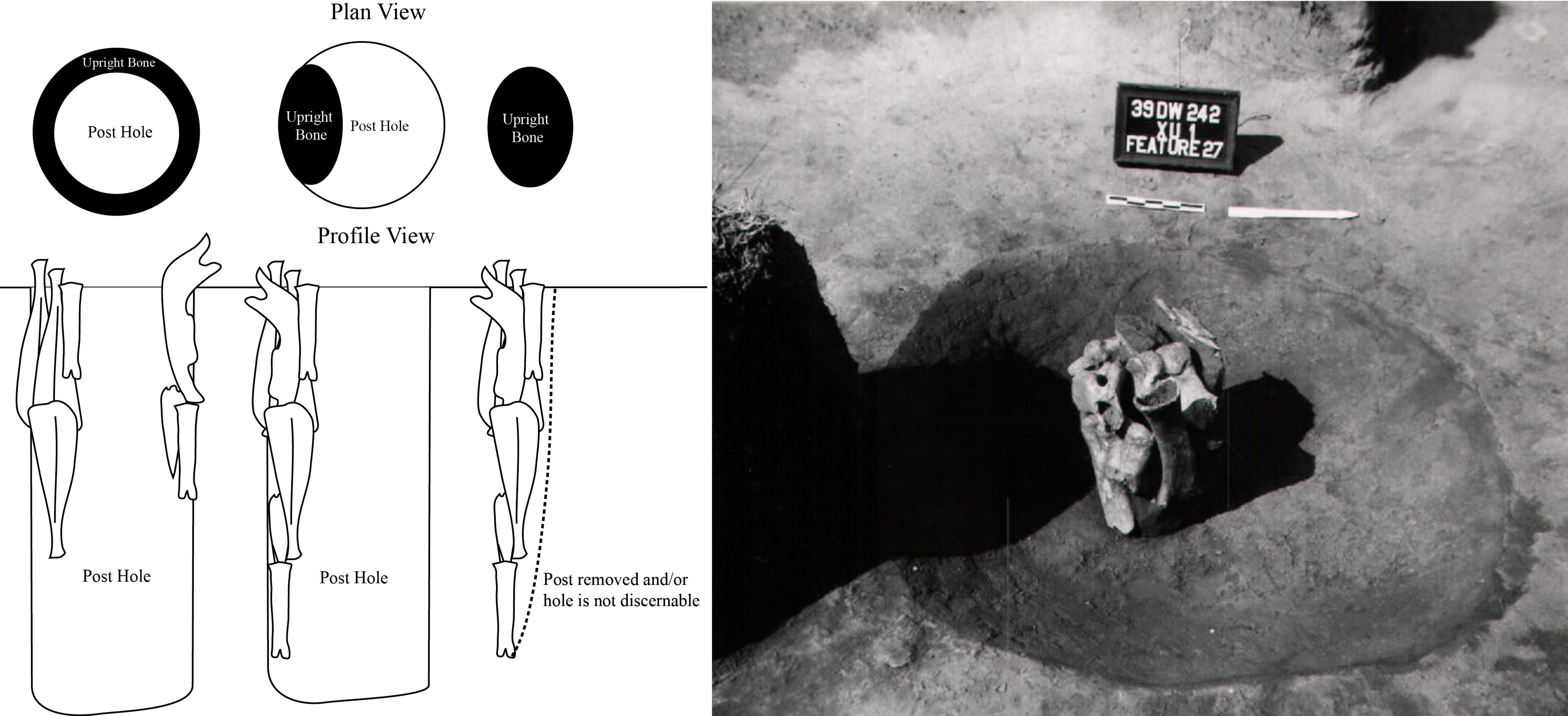
The second paper is a summary of archaeological features called bone uprights that appear in Alberta and across the Northern Plains. These features consist of animal bone (usually bison) that was vertically embedded in the ground. Archaeologists have come up with several ideas to explain these curious components of pre-contact sites.
A sample of bone upright images from Reid Graham and John W. Ives’ paper in the 2019 issue (reproduced with permission).
The title of the current volume – “Advancing archaeology: Industry and practice in Alberta, 2019,” refers to Terry Gibson’s legacy in the province and an important goal of the Occasional Paper Series. We hope the series provides a venue to CRM archaeologists, heritage managers and others to improve the discipline in Alberta. Interested authors can pitch a paper or idea to the editorial committee.
Also, you can download previous volumes of the Occasional Paper Series for free:
Written by: Emily Moffat, Regulatory Approvals Coordinator, Archaeological Survey of Alberta
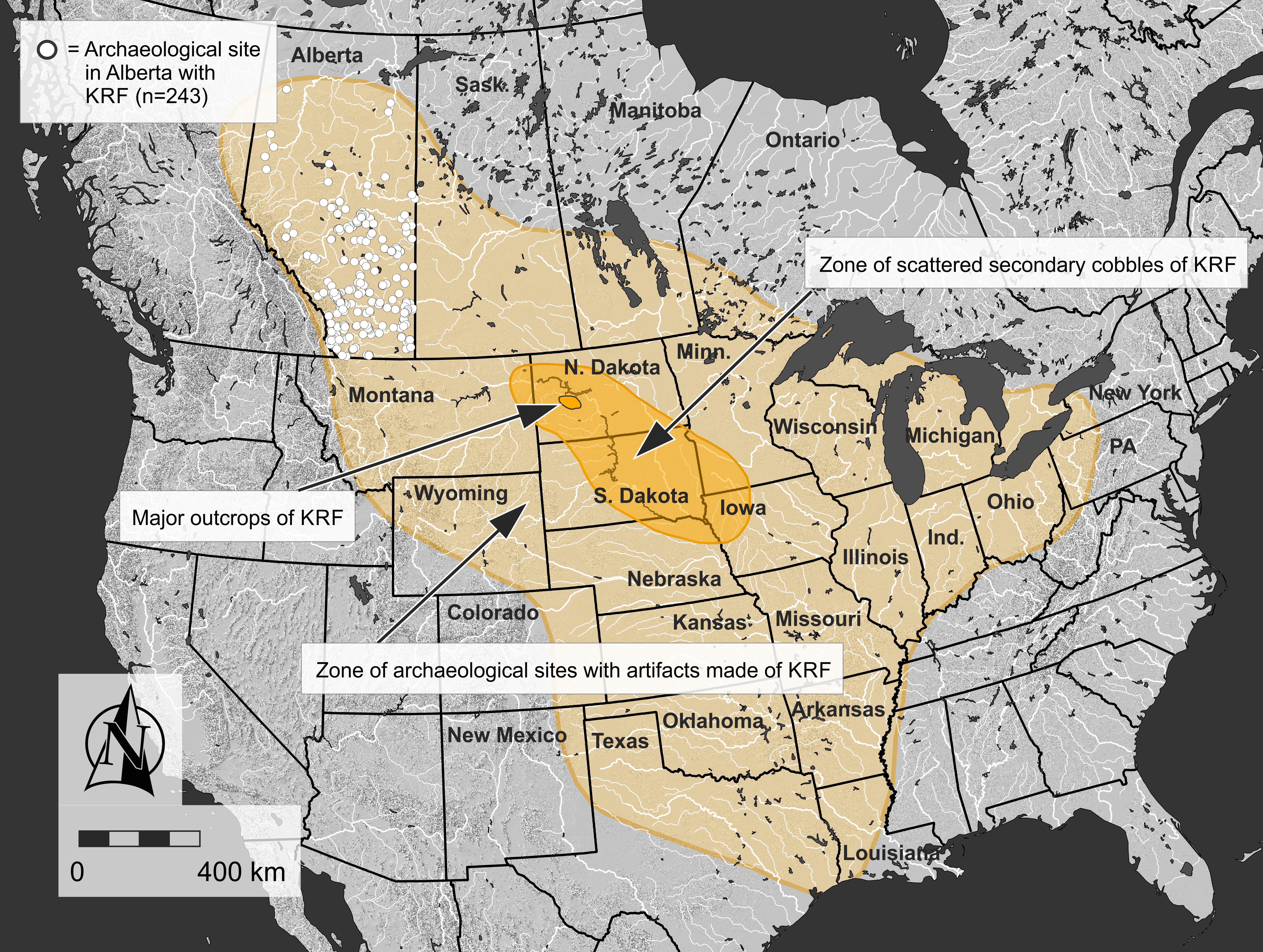
Stone tools were central to life in pre-contact North America and the rocks that they were made of were highly valued. The archaeological record throughout vast regions of North America, including much of Alberta, contains Knife River Flint (KRF), one of the most significant and intriguing tool stones used before the arrival of Europeans. KRF gets its name from the Knife River, a tributary of the Missouri River that flows through the United States Midwest and Southeast Regions.
In an era of limited human mobility compared to modern times, KRF was regularly transported hundreds of kilometres from its source in North Dakota, where it was quarried for thousands of years. A relatively small geographical region contains the majority of quarry pits and this location is the hub of KRF’s widespread distribution.
Map showing the major source area where Knife River Flint was quarried, the area where scattered cobbles were collected, and the overall extent of Knife River Flint artifacts based on published records. White circles show the extent of archaeological sites in Alberta that have produced a Knife River Flint artifact (Source: Todd Kristensen).
Stone tools and debitage, also known as lithics, are one of the most common types of artifacts found in Alberta. In the past, stone tools were an essential part of Indigenous ways of life. These stone tools and associated debitage (pieces flaked off while the stone tool was being manufactured) are made from a variety of stone types, but generally they need to be produced from quality raw materials. The characteristics of a quality raw material for making stone tools include stones that are finer-grained, somewhat brittle and uniform in texture and structure, and have few or no inclusions because these might make the rock break in unpredictable ways. Some of the highest quality material that was used in Alberta in the past comes from other places around North America, such as Knife River Flint from North Dakota, obsidian from British Columbia and the northwestern United States, and other types of cherts, argillites and other materials from neighboring provinces and states. However, several material types are available locally. Some of the most common types available in Alberta include quartzites, siltstones, cherts and petrified wood. In East Central Alberta, a common type of rock utilized by Indigenous groups in the past was pebble chert. There are areas where this stone is readily available and it can be high enough quality to be knapped into tools. While these pebble cherts can sometimes be found today in road cuts or blowouts all across East Central Alberta, there are two pre-contact quarries and associated archaeological sites near Consort, AB where large concentrations of these materials were found, collected and utilized. At these sites, there is evidence that Indigenous groups used rounded and fist-sized pebbles of chert to make stone tools.
The Misty Hills quarry site and complex (Borden block EkOp) is unique because it has large densities of both high quality chert and quartzite pebbles found in more than 130 blowouts across the site. In addition to the raw pebbles, there are many associated quarry Read more →
Written By: Colleen Haukaas (Archaeological Survey)
This week’s post is an update on archaeological project and site data for 2018 from the Archaeological Survey. Click the image below the see the full size.
Disclaimer: the archaeological site counts for 2018 are not final. They are constantly being updated as consultants and researchers submit their reports to the Archaeological Survey.
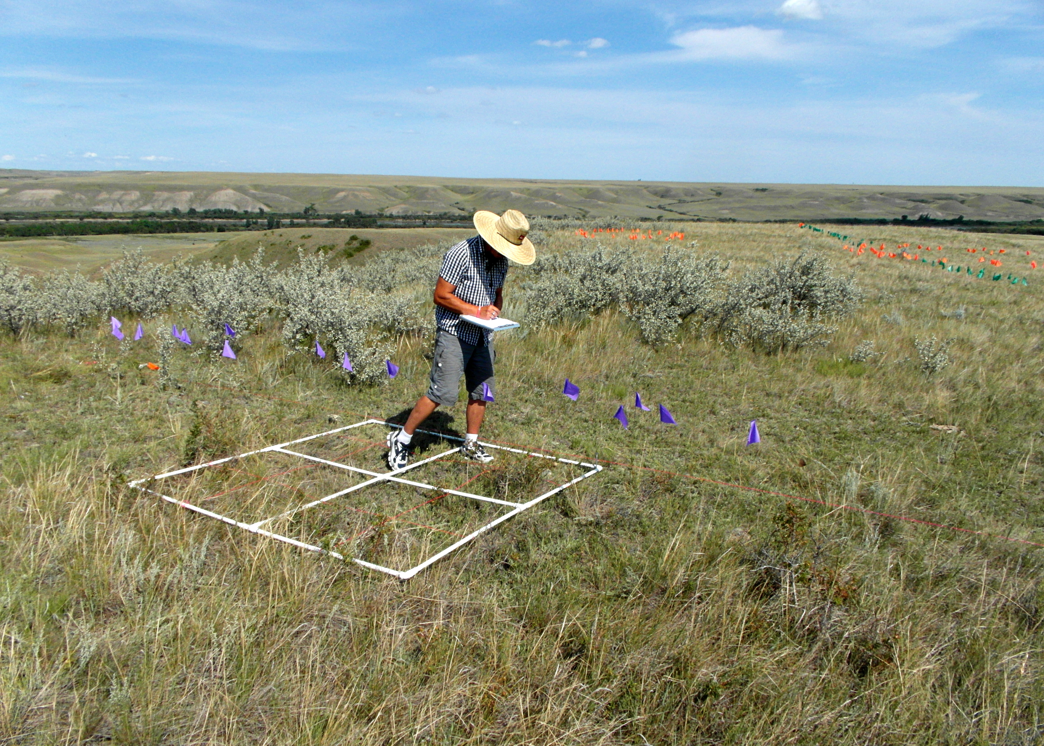
Field assistant mapping a medicine wheel. Purple and green flags mark spokes, orange flags mark cobble rings.
Often, archaeological discoveries are thought to only result from physical archaeological surveys. However, later data analysis and computer modeling can also provide important insights not easily seen in the field. Recent efforts to reconstruct possible past travel routes along the Red Deer River north of Brooks help illustrate just such a situation. Exciting archaeological finds were made, both through traditional archaeological survey techniques in the field, as well as with modern computer modelling approaches later in the office. These finds highlight the importance of viewing the past not simply as a series of isolated archaeological sites, but rather as a continuous cultural landscape.
Two seasons of fieldwork, consisting of more than 400 km of pedestrian survey, were conducted along the edges of the Red Deer River valley for some 43.5 km of the river’s course. The area was situated in some of the warmest and driest parts of the province, with vegetation consisting primarily of grasses, a few shrubs and vast swaths of prickly pear cactus. While some portions were virtually devoid of vegetation, unusually high amounts of precipitation throughout the region had encouraged thick grass growth in most other areas, and had kept the prairie a rich green colour for much longer than usual. Hidden within that thick cover of grass were large numbers of archaeological cobble features – the location of close to 1,000 of which were recorded with GPS. Unsurprisingly, the vast majority of features recorded during the fieldwork were standard cobble rings that marked the locations of past tipis. Also recorded, however, were significant numbers of other types of cobble structures, like standard cobble cairns and cobble arcs, as well as more unusual features , like tailed cobble rings, hollow cairns, and medicine wheels.
Southern Alberta is home to a greater number of medicine wheels than any other jurisdiction, and the Red Deer River appears to be a particularly rich location for them. Image provided by Terry Beaulieu.
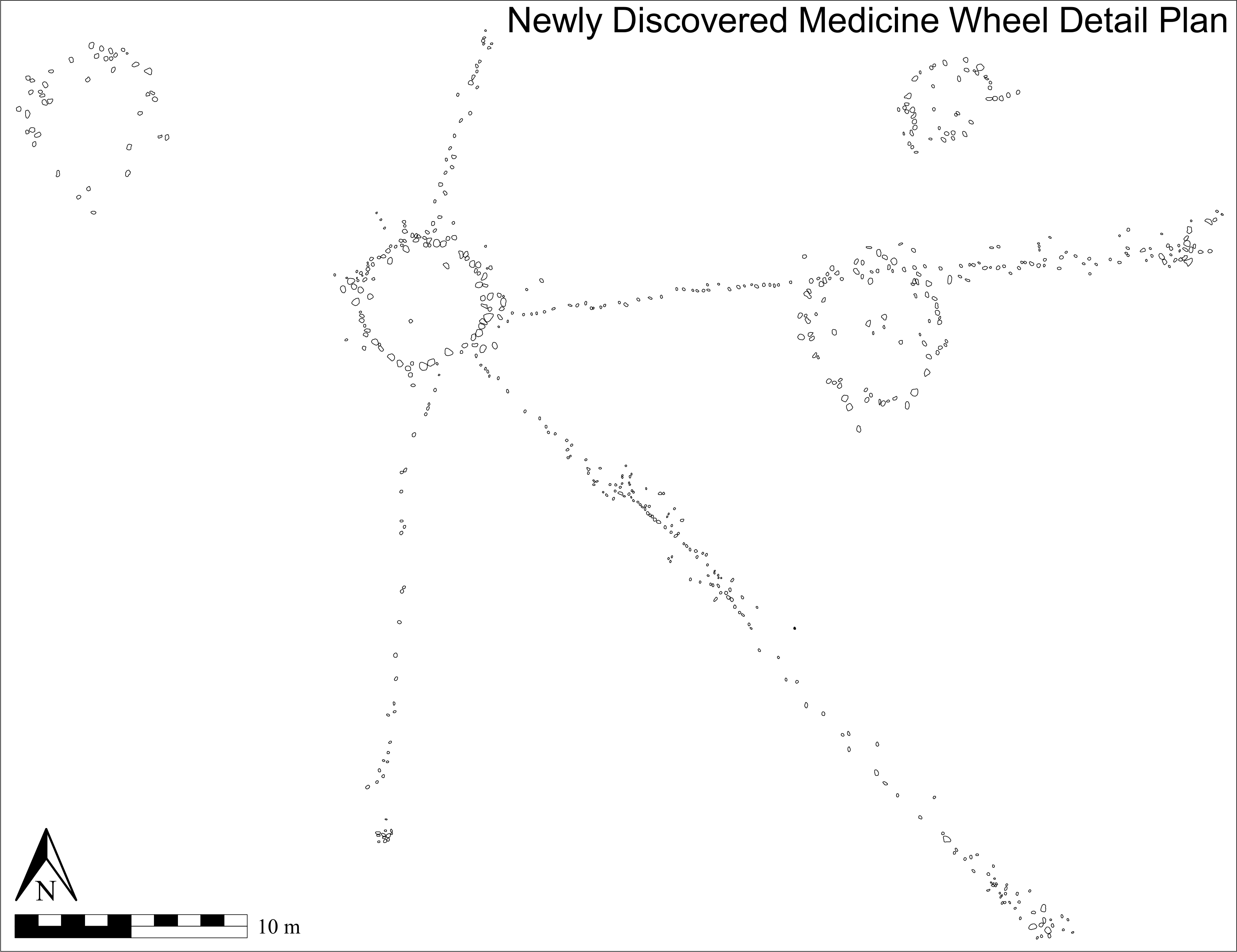
A total of five known medicine wheels were located in the area. Due to land access issues, however, only two of the five were visited during the present investigation. One new medicine wheel, though, was discovered. Like the other five medicine wheels in the vicinity, the newly discovered medicine wheel lies quite close to the valley edge, overlooking the Red Deer River to the east. It has a very well defined 5.25 m diameter central cobble ring from which four less-well defined linear cobble spokes radiate. The three longest spokes each terminate at a cobble cairn. A cobble ring is bisected along its northern edge approximately midway along the east northeast running spoke and a tailed cobble ring, along with a standard cobble ring, lie close by.
The wealth of locational data collected for the recorded cobble features was critical to computer analyses later conducted in the office. Close to 1,000 data points – the locations of archaeological cobble features – were imported into a geographic information system (GIS) to form the basis of a sophisticated spatial modeling analysis. Archaeological applications of GIS have often been criticized for placing too much emphasis on the physical environment and of therefore being guilty of excessive environmental determinism. The modelling approach taken in this study was designed to intentionally emphasize cultural elements in order to address such concerns with what is generally considered to be a landscape archaeological approach.
One of the ways cultural elements were emphasized was through identifying and integrating the concept of place into the GIS analysis. Incorporating locations into the GIS that had been identified based on place names known to have been used by Indigenous people was one such method employed. Past places were also determined by using the archaeological information collected in the field. Locations indicative of important places, for example, were identified by locating significant concentrations of standard cobble rings, or finding the presence of known ceremonial features such as medicine wheels and hollow cairns, among others. GIS modelling was then conducted in an effort to locate and model pedestrian travel routes that may have been employed by past people during their summer travels through the region when heading to the nearby important location of Hunting Hill.
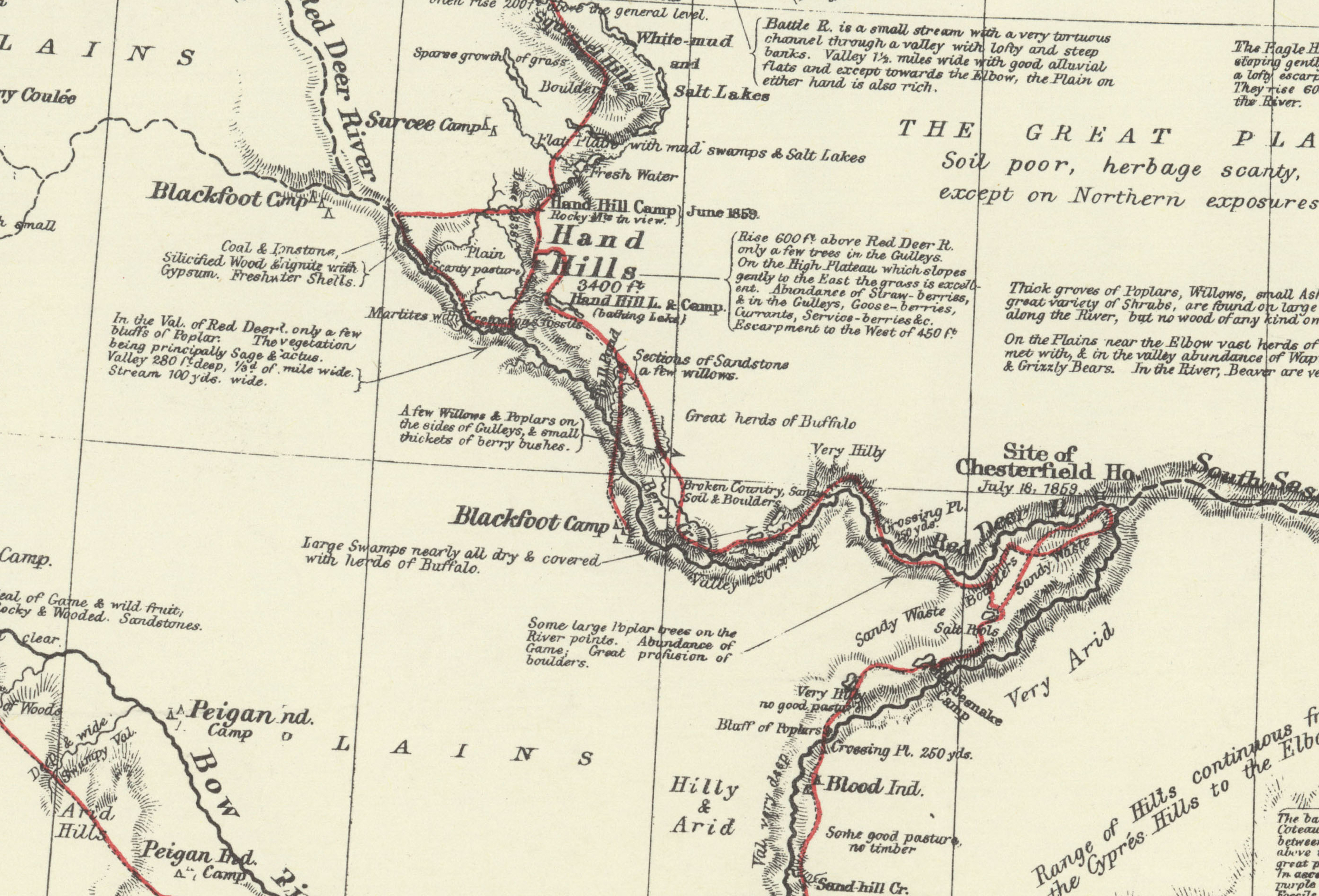
A segment of Palliser’s 1865 map showing the route he travelled (marked in red) down Bullpound Creek and across the Red Deer River when visiting a Blackfoot Camp. Provided by Terry Beaulieu.
The GIS models indicated a crossing point located near where Bull Pound Creek empties into the Red Deer River. The problem, however, was that most early maps of the area indicated the closest known river crossing was upstream from there at Lord Lorne Crossing. It therefore appeared the GIS models were flawed. Further investigation, however, revealed that was likely not the case.
In the summer of 1859, Captain John Palliser travelled through the region as part of his multi-year expedition through western Canada. He was one of the first Europeans to visit the region and the maps he produced are some of the earliest created of the area. During those travels he wrote of visiting “Blackfoot Indian” camps. The route he travelled during one of those visits ran down the east side of Bull Pound Creek and crossed the Red Deer River at the point where the creek emptied into the river – at almost the exact location indicated by the GIS models. Given that Palliser was likely being guided by residents of the camp, who would have been familiar with the best routes and river crossings, the concurrence between Palliser’s map and the GIS models indicates the modelling process was indeed successful in identifying the location of a river crossing point used by past peoples.
Captain John Palliser was one of the first Europeans to visit western Canada and the maps he produced are some of the earliest created of the area. Source: Wiki Commons
It is interesting to note that less than a quarter century later, when George M. Dawson, of the Geological Survey of Canada, created his maps of the area, the crossing near the mouth of Bullpound Creek was no longer recognized by those creating the maps. Lord Lorne Crossing, significantly upstream from the mouth of Bullpound Creek, had instead replaced it as the important crossing place. Such a shift illustrates how quickly changes occurred on the prairies in the mid to late 1800s, and how fast Indigenous information became lost and undervalued during European map making. Information about the locations of significant places to past people does not have to remain lost and forgotten, though, and can be resurrected through thorough investigation and careful research, as is evident by the discovery of a previously unknown medicine wheel and the identification of a forgotten river crossing. Both are significant additions to the archaeological record that, in addition to helping inform our understanding of the past, also show that important new archaeological discoveries are still being made, whether through old fashioned archaeological legwork or modern computer analysis.
Written by: Terry Beaulieu, Ph.D. Graduate, University of Calgary
Adornment reflects a symbolic visual language that includes materials and designs that contain communally understood messages. That is, the clothing or items we wear convey information about us to other people. The expression of these messages through clothing, tattoos, jewelry, or body paint, conveys information about an individual, group, society, or religion. Beading, and other embroidery techniques, can be seen as one aspect of adornment for Indigenous groups, and one that played a central role in cultural preservation for many groups post-European contact.
Beads have been found in the archaeological record as early as 40,000 years ago, and are staples in decorative adornment. Beads can be fashioned from many different natural materials including plant seeds, stone, gems, shell, bone, or metal. While plant-based seeds are the easiest to manufacture due to their availability, beads made from bone, metal, gems, or semi-precious stone require more effort and technology to produce, and are therefore more highly valued.
Prior to European contact, Woodland and Plains cultures of North America decorated the skins of animals, tree bark, and their own bodies with locally available and traded materials. Materials such as seeds, berries, porcupine quills, moose hair, Read more →


