Written by: Todd Kristensen, Archaeological Survey of Alberta and Robert Gustas
The Archaeological Survey of Alberta is pleased to kick-off Occasional Paper Series No. 44 with its first six articles, which are available for free download.
The Occasional Paper Series is an annual volume of articles that explore cultural heritage in Alberta and surrounding regions. The first volume was published in 1976 and the current volume celebrates the series’ 50-year-anniversary. This issue is dedicated to sharing synopses or components of particularly insightful graduate theses and dissertations written over the last 15 years.
The volume is dedicated to archaeology in Alberta’s Rocky Mountains, Foothills and their margins. The initial three articles were released in Spring; below are summaries for the remaining six articles. They explore projectile points, caches, plant residues and more.
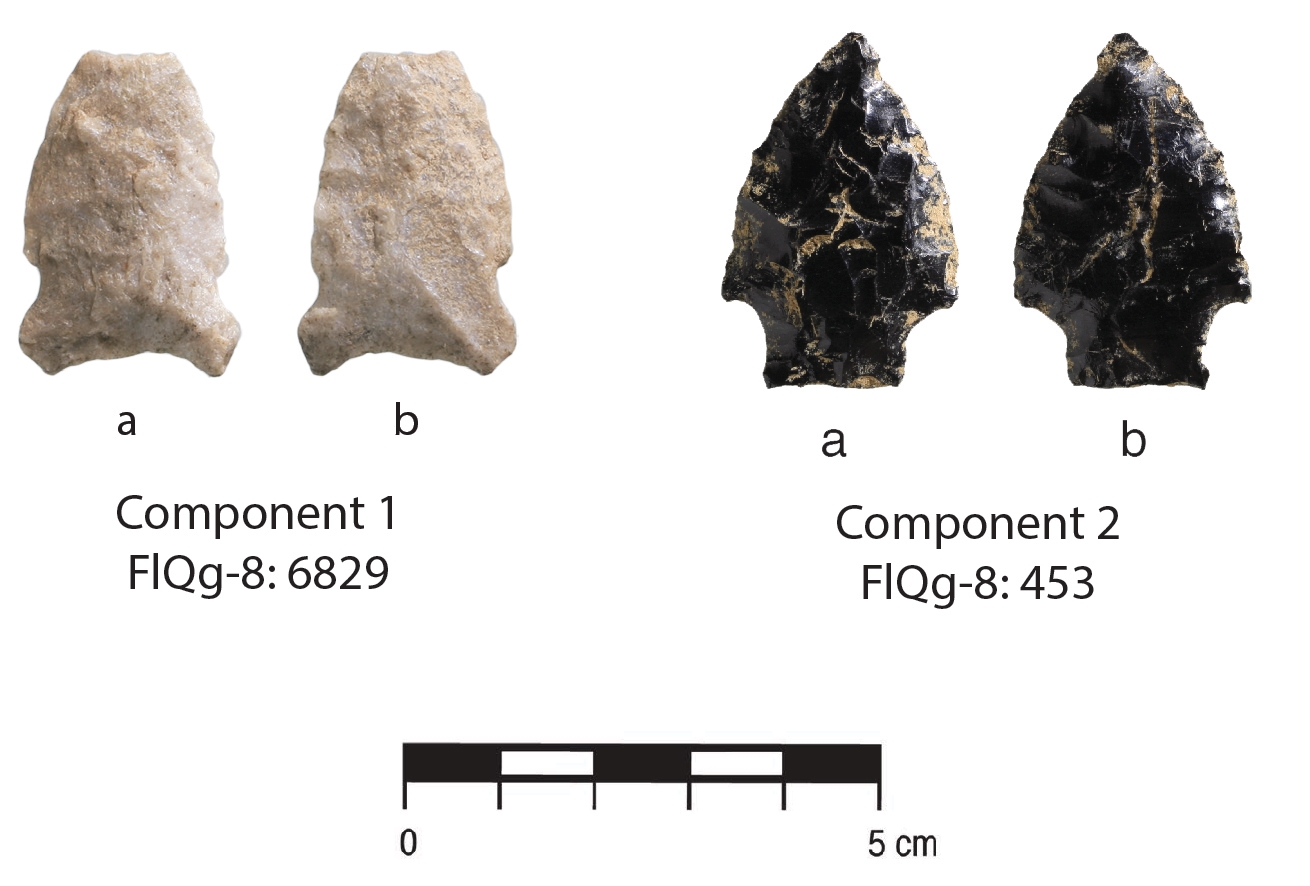
The fourth paper in the volume explores Oxbow and McKean stone tool assemblages at a site northeast of Hinton, Alberta. Taylor Graham applies statistical analyses to tease apart reduction events among the 6,000 artifacts recovered.
Projectile points recovered from FlQg-8. Source: Graham, 2024.
The Archaeological Survey of Alberta is proud to kick-off Occasional Paper Series No. 43 with its first three articles, which are available to download for free:
Written by: Todd Kristensen and Emily Moffat, Archaeological Survey of Alberta
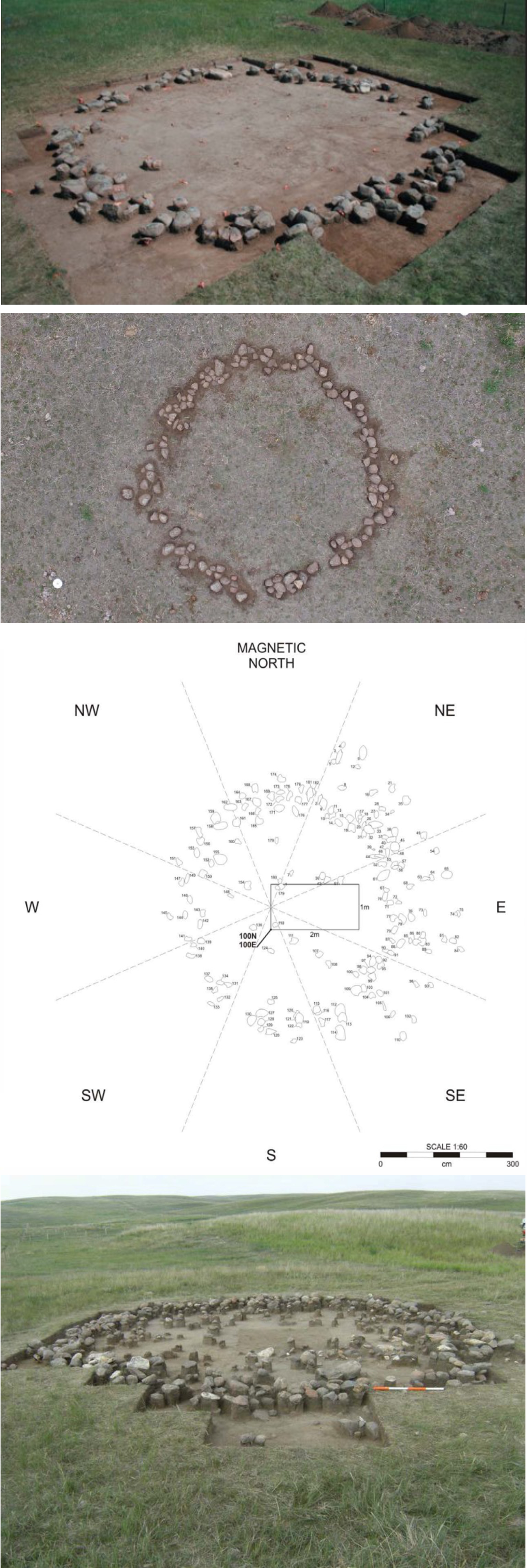
Small rings of rock appear across Alberta’s prairies. These stones once weighed down the bison hide covering of tipis – a type of dwelling used by generations of First Nations. Tipis, and the remnants of them, have drawn the attention of archaeologists and historians in the province for over 70 years. It is estimated that Alberta had a million stone circles before being displaced by farming and other developments. Currently, the province has over 8,000 recorded archaeological sites with tipi rings: some are a single circle (a small camp) while others host over 200 rings in one spot (a large gathering of family and allies). New figures and imagery here highlight decades of archaeological research and help visualize how records of tipi rings can reveal dimensions of pre-contact life.
Exposed, excavated, and mapped tipi rings in Alberta. Source: permits 08-110, 09-050, 11-048, and 21-046.
Editor’s note:The research presented in this blog is from a published journal paper co-authored by Timothy Allan, John Ives, Robin Woywitka, Gabriel Yanicki, Jeffrey Rasic and Todd Kristensen.
Ice sheet margins derived from: Dalton, A. S., M. Margold, C. R. Stokes, L. Tarasov, A. S. Dyke, R. S. Adams, S. Allard, et al. 2020. An Updated Radiocarbon-Based Ice Margin Chronology for the Last Deglaciation of the North American Ice Sheet Complex. Quaternary Science Reviews 234: 106223–27. https://doi.org/10.1016/j.quascirev.2020.106223.
Written by: Todd Kristensen, Archaeological Survey of Alberta
Alberta was once covered with glacial ice. Around 22,000 years ago, portions of the ice that sprawled across the province were over 1.5 kms thick. When the ice began to melt, it retreated in two directions (northeast and west) and exposed a pathway dubbed the Ice-Free Corridor that crossed through Alberta and connected previously exposed land masses over the warmer United States and a colder but drier region to the north called Beringia (parts of Northwest Territories, Yukon, Alaska, and Russia). People had settled into the corridor in what is now Alberta by 13,000 years ago. Where did they come from?
The melting of ice sheets over Alberta from roughly 22,000 to 13,000 years ago (based on data from Dalton et al. 2020). The ages are ‘calibrated’ from radiocarbon dates.
New archaeological discoveries are pushing back the ages of when people arrived in Beringia and to the south in the United States. To help understand which of those two areas are the likely source of people who came to Alberta, archaeologists have recently looked at the tools they were carrying, specifically, what kinds of stone the tools were made of. Some of the rock types that people used to craft things like spear points, scrapers and knives, are only found in certain areas in North America: their presence in Alberta’s archaeological record indicates that the stones were transported from far away. In turn, archaeologists look at changes in those ‘toolstone’ materials to track changing relationships; in the absence of other things that don’t preserve in Alberta’s soil, stone tools reveal where people migrated from, who they were interacting with (their ‘kin’) and how that all changed over thousands of years.
Editor’s note: The Archaeological Survey of Alberta is proud to release the complete volume of Occasional Paper Series No. 42, available for free download.The volume is dedicated to Alberta archaeologist Jack Brink and the initial blog featured the first five articles. This post features the remaining seven articles, which focus on a variety of archaeological topics.
Written by: Todd Kristensen, Archaeological Survey of Alberta
In the sixth paper of the volume, staff of Lifeways of Canada Limited summarize three seasons of excavation at an important archaeological site in southern Alberta. The Junction Site has produced a number of interesting pit features associated with Late Precontact Period bison kills, processing areas and winter camp activities.
A boiling pit feature and profile from the Junction Site. Source: Vivian and Blakey, 2023.
Editor’s note: The Archaeological Survey of Alberta is proud to release the complete volume of Occasional Paper Series No. 42, available for free download.
Written by: Todd Kristensen, Archaeological Survey of Alberta
Cover of the 2023 Occasional Paper Series. Artwork by Shannon Ford.
Unlike previous volumes, in which papers are published and released throughout the year, the current volume is based on an archaeology conference session dedicated to the widely respected Alberta archaeologist Jack Brink, and all articles are here released concurrently. This blog features five articles (out of 12 in the issue) that focus on archaeological work at the famous Head-Smashed-In Buffalo Jump UNESCO World Heritage Site in southern Alberta. The rest of the 12 articles will be published next week.
Editor’s note: The banner image about was reproduced with the permission of the Provincial Archives of Alberta. Sled dogs were critical for moving goods in northern Alberta, like this dog team outside a trade post in the Fort McMurray area in 1911.
Written by: Todd Kristensen, Archaeological Survey of Alberta
Domestic dogs have likely been in Alberta for least 5,000 years and some researchers think they arrived with the first humans in North America over 13,000 years ago. What role did they play in Indigenous life? And how did that role change when horses arrived in the 1700s?
Based on archaeological records and historic accounts, people on the prairies of southern Alberta likely had about 4-6 dogs per family. These pets could transport about 90-270 kg of goods using a travois (a series of poles attached to a dog’s back) or pack saddles. Dogs helped move tipi hides and poles (up to 100 kg per tipi) as well as dried meat and tools from camp to camp. Before Europeans arrived, Plains communities packed up and moved all of their belongings about 10-40 times a year, which helped them stay in contact with moving bison herds that were the main source of food and materials. Trains of several hundred pack dogs carried goods on trading expeditions.
A comparison of horse and dog characteristics that influenced their relationships with people in Alberta. Illustration by Terra Lekach.
Written by: Todd Kristensen, Regional Archaeologist
Recent archaeological discoveries in Alberta’s Boreal Forest are confirming the antiquity of Indigenous occupation of this place and refining ideas of how pre-contact people adapted to landscapes. Two fresh articles in the most recent issue of the Archaeological Survey of Alberta’s Occasional Paper Series explore ancient sites found in northwest Alberta.
Written by: Todd Kristensen, Regional Archaeologist
Most archaeology in Alberta happens in advance of industry development when consultants are hired to ensure that archaeological sites are avoided or excavated prior to ground disturbance. For the last decade, about half of the new sites recorded in Alberta are found during forestry programs when consultants look for archaeological material in advance of tree harvesting and logging road construction. The contribution that forestry-based archaeology makes in Alberta is large.
Why do forestry operators have to hire archaeological consultants?
Industry developers are generally required by law, through the Historical Resources Act, to submit development plans to the Archaeological Survey of Alberta, who then reviews the footprints for overlaps with known archaeological sites or areas with potential for archaeological material. Forestry is one of Alberta’s largest industries in terms of spatial area: about 87,000 hectares are harvested each year and over 2 million hectares have been commercially logged in Alberta since 1990. Archaeological sites in harvest areas can be disturbed during road construction, during logging (by heavy machinery that cuts trees or transports them), and by site preparation practices that relate to reforestation.
In many areas in Alberta, the ground is intentionally disturbed after harvest to encourage regrowth of desired seedlings: about 18,000 hectares of land in Alberta are annually subjected to mechanical site preparation by forestry operators. Archaeological sites in Alberta’s Boreal Forest are often quite shallow (within 30 cm from the surface) meaning that forestry can have large impacts on the province’s preserved heritage. In the big picture, the vast majority of Alberta’s forests and all archaeological material in the province are public resources. For these reasons, forestry operators are responsible for detecting and avoiding archaeological sites during development.
Alberta’s forested ecoregions (data from Alberta Parks 2005). The Parkland is not a commercially harvestable forest type. South of the Parkland is Alberta’s Prairie ecoregion. Source: Todd Kristensen.