Written By: Colleen Haukaas, Archaeological Survey
This post looks at archaeological sites recorded in Alberta under 2022 archaeological permits issued by the Archaeological Survey. Part One of this post has more information about archaeological permits, field activities, and professional activities.
The majority of sites each year are recorded during CRM projects in response to potential impacts from proposed developments. Researchers in universities, museums, and other research facilities also record sites each year. Together, archaeologists record and re-record (revisit) 500-700 sites annually.
There are more than 40,000 known sites recorded in Alberta, ranging from small scatters of a few artifacts to complex sites like the Quarry of the Ancestors, Áísínai’pi, and Cluny Fortified Village sites. The infographic below shows basic categories of information about sites recorded in 2022, including site class and type.
You can explore previous Survey in Numbers to compare statistics year over year
Written By: Colleen Haukaas, Archaeological Survey
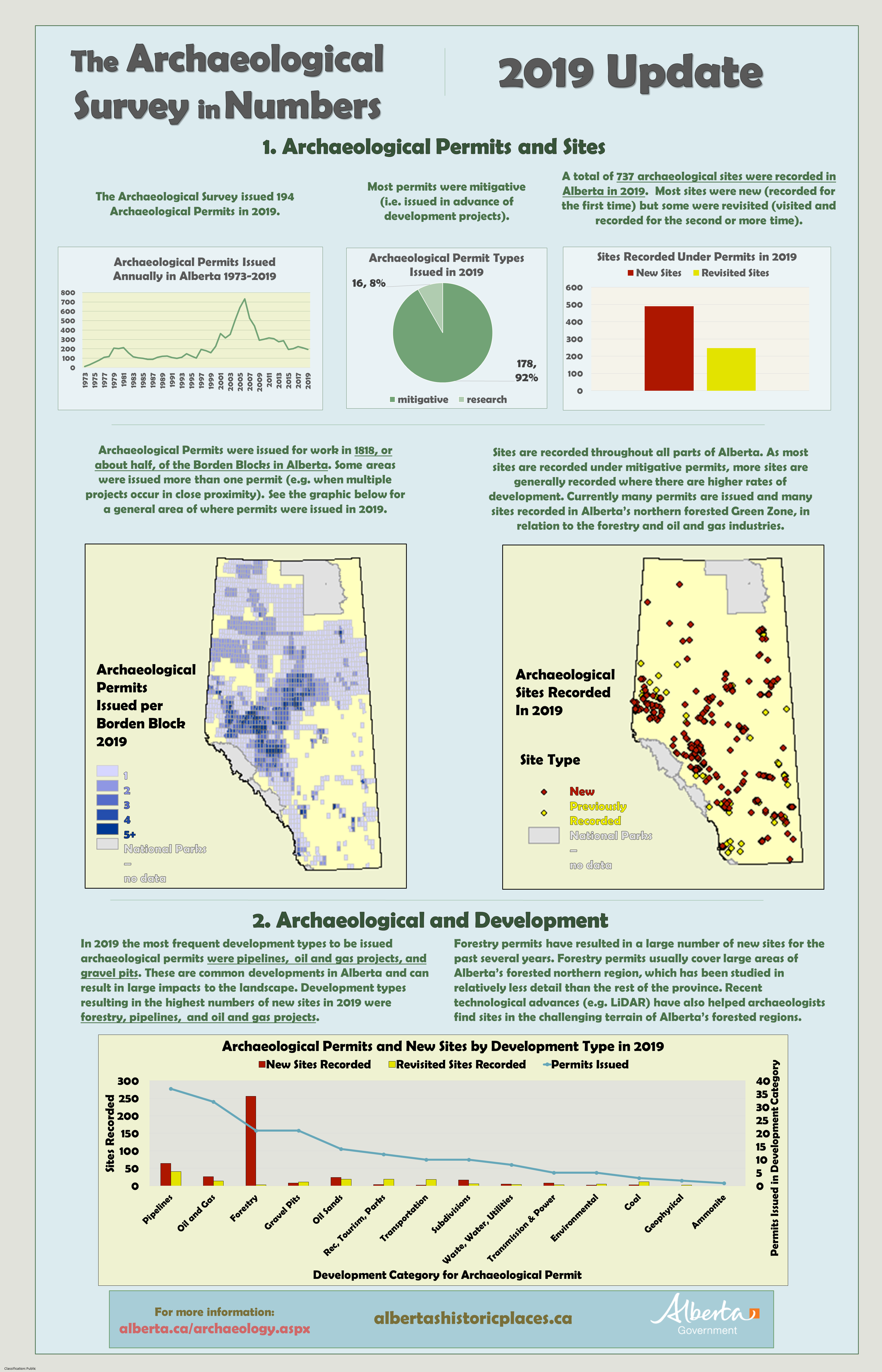
This week’s post is an update on 2022 archaeological permits from the Archaeological Survey of Alberta. All archaeological field research in Alberta must be carried out under a permit issued by the Archaeological Survey by a qualified professional archaeologist. In 2022, the Archaeological Survey issued 209 permits to 53 professional archaeologists at 19 companies.
As in previous years, the majority of permits were issued for mitigative assessments, or assessments to determine if a proposed development may impact a known of potential archaeological site. The majority of assessments were Historical Resources Impacts Assessments (HRIAs), which are generally preliminary examinations intended to determine whether a development will impact archaeological sites. More detailed site excavations are less common in mitigative archaeology, but do occur when sites cannot be avoided by a development. In 2022, mitigative archaeologists carried out 194 assessments, which included the excavation of more than more than 27,000 shovel tests and 476 square meters of formal site excavation.
The infographic below includes details about archaeological permits and assessments, based on information provided to the Archaeological Survey in permit applications, reports and other reporting materials.
Part two of this post will discuss the archaeological sites recorded in 2022.
You can explore previous Survey in Numbers to compare statistics year over year.
Written By: Colleen Haukaas, Archaeological Survey
This week’s post highlights archaeological sites recorded in 2021 under archaeological permits issued by the Archaeological Survey.Part One of this post discussed archaeological permits, archaeologists, and archaeological field activities from 2021.
More than 40,000 archaeological sites have been recorded in Alberta, and archaeologists record 500-700 new sites per year. Sites can include a few artifacts or complex, multi-site areas like Áísínai’pi/Writing-on-Stone. Most sites in recent decades are recorded by archaeologists working in the cultural resources management (CRM) industry. CRM archaeologists work with developers to avoid potential impacts to known or potential archaeological resources in Historic Resources Impact Assessments. Sites are also recorded by researchers at universities, museums, and other institutions, who tend to conduct detailed research at the same sites year-to-year. Site records are managed and archived at the Archaeological Survey’s Alberta Archaeological Sites Inventory.
You can explore previous Survey in Numbers to compare statistics year over year.
Written by: Colleen Haukaas, Archaeological Survey
This week’s post is an update on the permit management system from 2021 from Alberta’s Archaeological Survey. Archaeological research in Alberta in Alberta that involves surveying and testing land or excavating archaeological sites must be conducted under an Archaeological Research Permit. Permits must be held by an archaeologist who meets professional qualifications. The infographic notes that 58 professional archaeologists held permits in Alberta in 2021; however many other archaeologists work in Alberta archaeology in addition to permit holders, such as field and laboratory technicians.
Most archaeologists in Alberta work in the cultural resources management (CRM) industry, where they work together with the Archaeological Survey and industry partners to avoid impacts to historic resources from proposed developments. CRM archaeologists working under mitigative archaeological permits assessed more than 200 projects in 2021 in all areas of Alberta. Archaeologists dug an astounding 37,000+ shovel tests in 2021 alone, on top of the excavations, backhoe tests, and other inspections they carried out that year.
Most permits were issued for Historical Resources Impact Assessments (HRIAs). Under this type of permit archaeologists determine whether a proposed development will impact archaeological resources. Many tests used in initial HRIAs are negative (shovel tests, sediment exposure examination, backhoe tests). This result is expected- tests are used to expediently locate the presence of cultural materials. After sites have been located, more detailed site evaluations (e.g. test units, excavations) are used for further assessment.
Part two of this post will discuss the archaeological sites recorded in 2021.
You can explore previous Survey in Numbers to compare statistics year over year.
Written by: Colleen Haukaas, Archaeological Survey
From the Alberta government’s Historic Resources Management Branch, the Spring 2022 edition of the Listing of Historic Resources is now available. The Listing is a geospatial product showing lands that are known to contain or likely to contain historic resources (i.e. archaeological sites, historic sites, palaeontological sites, Indigenous heritage sites) in Alberta. The Listing is designed to be used by developers, land agents and other professionals in the cultural resources professional sphere. Publishing the Listing allows us to more quickly communicate concerns about historic resources on the landscape, while also protecting some of the confidentiality of historic resource sites. Even though the Listing is targeted for professionals, anyone can access it. A new edition of the Listing each year in the spring and fall.
Category
Description
a
archaeological
c
cultural
gl
geological
h
historic
n
natural
p
palaeontological
Categories used in notations in the Listing of Historic Resources.
Written By: Colleen Haukaas, Archaeological Survey
This week’s post is an update on archaeological sites recorded in 2020 as part of the Archaeological Survey’s permit management program. Part One of this post discussed archaeological permits, archaeologists and companies, and archaeological field activities. This week’s post highlights information about archaeological sites recorded during field work under archaeological permit activities.
In Alberta, archaeological sites have been protected since the 1970s under what is now the Historical Resources Actas, “a work of humans that is of value for its prehistoric, historic, cultural or scientific significance.” One would not need to look far to see that Alberta has amazing archaeology, ranging at least 13,000 years, at sites like Writing-on-Stone/Áísínai’pi, Head-Smashed-In and other buffalo jumps, Wally’s Beach age megafauna, and many other amazing sites. Over 40,000 sites have been recorded in Alberta, and archaeologists record 500-700 new sites per year.
The majority of new sites today are recorded by archaeologists working with developers to avoid potential impacts to known or potential archaeological resources in a Historic Resources Impact Assessment. Any sites they might record are reported to the Archaeological Survey and added to the Archaeological Site Inventory, which is available to archaeological researchers and consultants. Sites are also recorded by researchers working at universities, museums, societies and other institutions. Researchers usually record fewer sites overall, and revisit the same sites year-to-year to continue detailed research.
You can explore previous Survey in Numbers to compare statistics year over year.
Written By: Colleen Haukaas, Archaeological Survey
This week’s post is an update on the Archaeological Survey’s permit management program from 2020. In Alberta, as elsewhere in Canada, archaeological sites are protected and managed through legislation, as archaeological sites and artifacts are thought to be of value to Albertans. Most of the work archaeological permits since the 1970s have been issued to professionals, or consultants, working in the cultural resources management (CRM) field.
Consultants in this field work with developers and the Archaeological Survey to ensure that proposed developments, such as subdivisions, well sites, waterlines, etc., will not impact known or potential archaeological sites. This work is crucial to ensure that Alberta’s development industries can continue while also avoiding impact to archaeological resources, which are non-renewable and best left in the ground. Since the permit management system was legislated in the 1970’s, CRM consultants have recorded tens of thousands of archaeological sites in all areas of Alberta and made immeasurable contributions to the stories and knowledge of Alberta’s past.
This infographic looks at some of the details of Alberta’s permit management program- How many permits are we issuing? How many are CRM (mitigative?) Where are the permit projects this year in the province? What types of research activities are archaeologists carrying out under their permits? Please stay tuned for Part Two of this infographic, which will look at archaeological sites recorded in 2020.
You can explore previous Survey in Numbers to compare statistics year over year.
Written by: Colleen Haukaas, Archaeological Survey
In April the Historic Resources Management Branch (HRMB) released the Spring 2021 Edition of the Listing of Historic Resources. The Listing is a biannual release of lands in Alberta that are known to contain or are likely to contain lands of a sensitive historic nature. Land parcels used in the Listing are Legal Subdivisions in the Alberta Township Survey system. The Listing is generated as a tool to aid developers, land agents, planners and other stakeholders when planning land-based development projects in Alberta.
Each land parcel in the Listing is assigned a Historic Resource Value (HRV) ranging from 1 to 5:
Historic Resource Value (HRV)
Description
HRV 1
contains a World Heritage site or a site designated under the Historical Resources Act as a Provincial Historic Resource
HRV 2
deactivated (formerly used to designate a Registered Historic Resource)1
HRV 3
contains a significant historic resource that will likely require avoidance
HRV 4
contains a historic resource that may require avoidance
Each entry is also assigned a category of the primary historic resource category of concern:
Category
Description
a
archaeological
c
cultural
gl
geological
h
historic period
n
natural
p
palaeontological
Sample map of the Listing of Historic Resources at Edmonton. Map was generated with the online Listing webmap.
A legal subdivision can have more than one HRV rating or category. For example, a legal subdivision that contains both an archaeological site and an area of high palaeontological potential may be classified as 4a, 5p.
The Listing is generated by gathering information from consultants and researchers working in archaeology, palaeontology, history and other industries in Alberta, and comparing their findings with known resources at the HRMB. Our staff use GeographicInformation Science software to compile and generate the Listing.
To view the new version of the Listing, see the online webmap version here. For more details or for information for developers, see our website.
Written by: Colleen Haukaas, Archaeological Survey
Join the Historic Resources Management Branch as we celebrate GIS Day 2020. GIS, or geographic information science, is a scientific framework for gathering, analyzing and visualizing geographic data to help us make better decisions. At the Historic Resources Management Branch, we have been using GIS since the early 2000s to better understand our historic resources.
GIS at the Historic Resources Management Branch
Alberta is home to tens of thousands of historic resources, and our Branch needs to be able to analyze where those resources are, if there are concerns about the resources, and the best way to address those concerns. At the Branch, we maintain several geospatial databases for our program areas: archaeology, palaeontology, Aboriginal heritage and historic structures. Each database is modified throughout the year as new information is made available (e.g. when new sites are recorded).
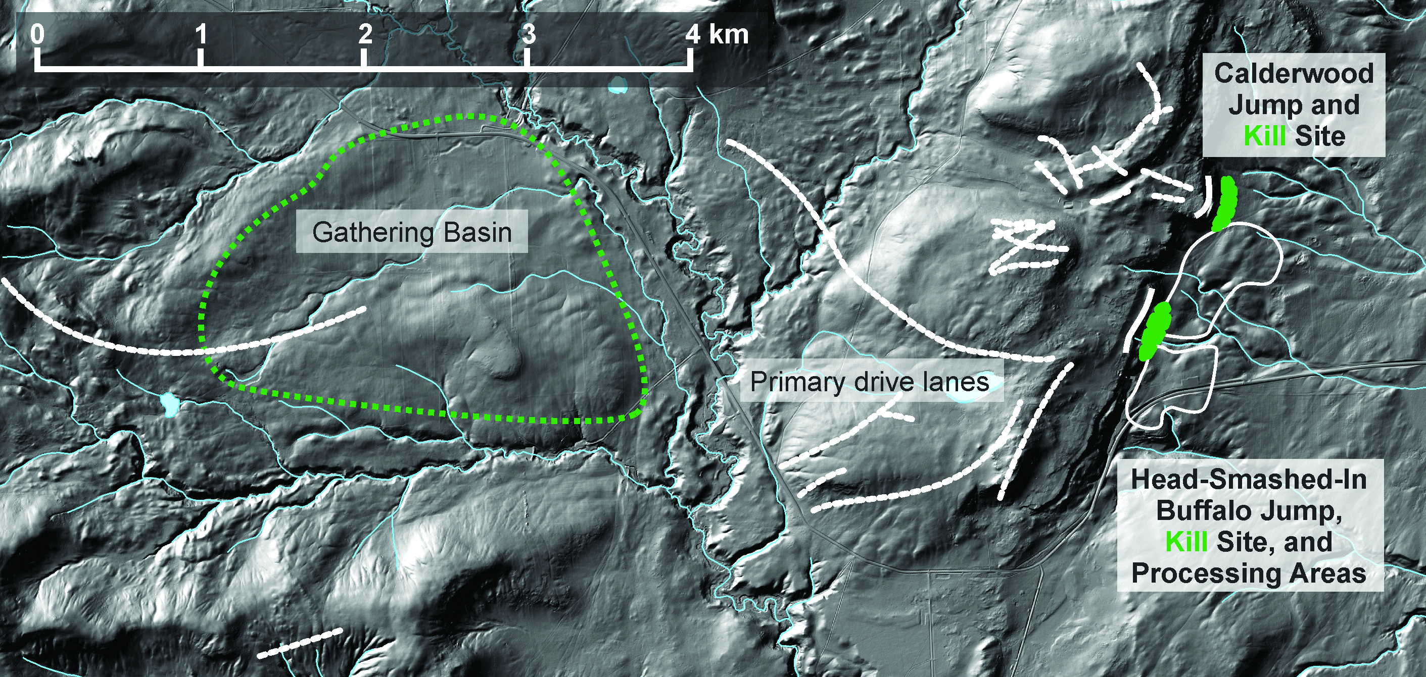
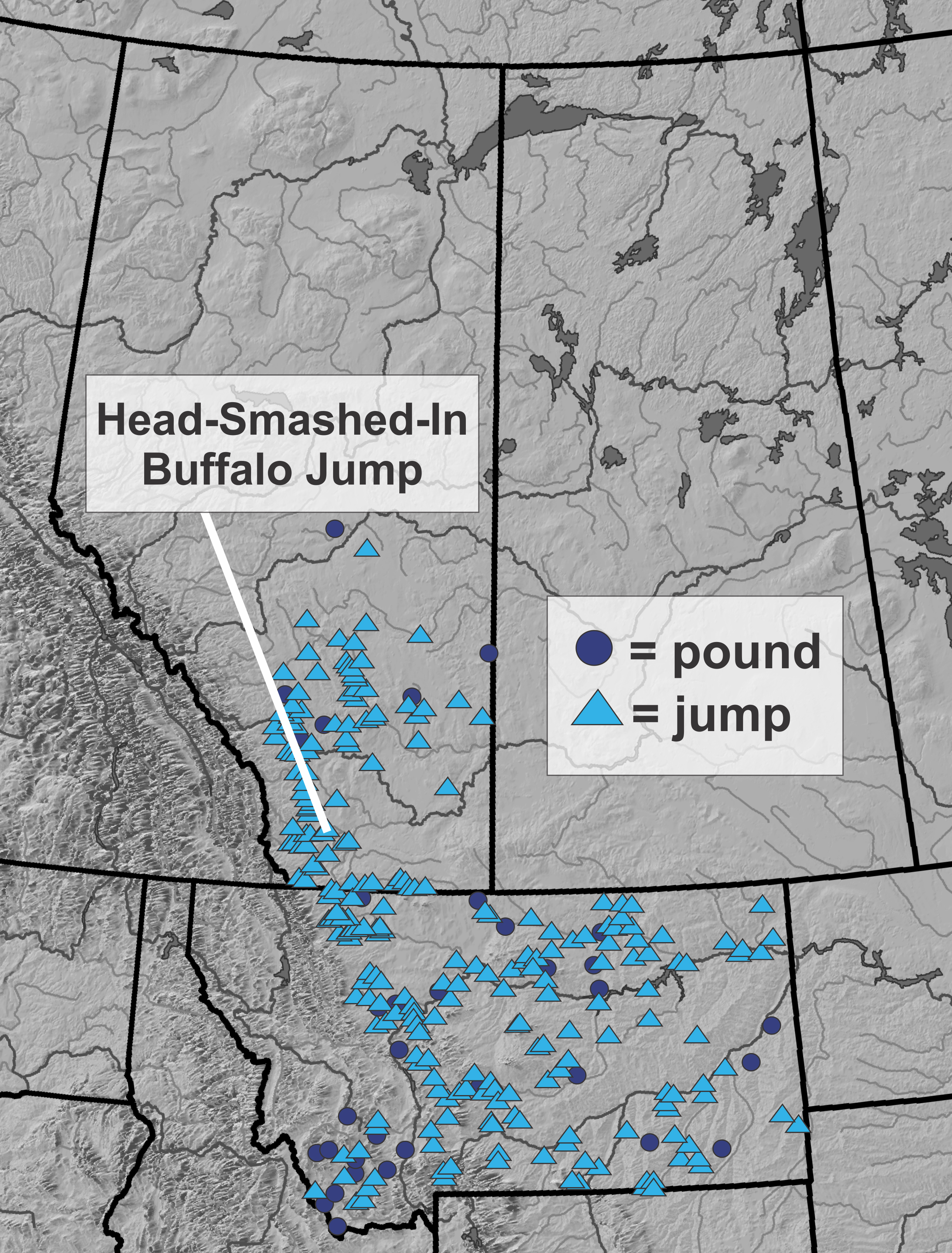
We investigate archaeological sites individually in research, but we also need to understand how sites relate to each other and to broader cultural and natural landscapes. GIS helps archaeologists understand these broader questions. The images below show how we use GIS to understand the broader context of archaeological sites Head-Smashed-In Buffalo Jump and Calderwood Buffalo Jump, courtesy of Todd Kristensen. Archaeologists have investigated the sites through methods such as survey, excavation and artifact analysis. Through GIS, we can then begin to understand the context of the sites within their local topography and see the gathering area, drive lanes and kill areas. We can also see how the sites fit into the broader tradition of bison jumps, pounds, and kill sites on the Great Plains.
The sandstone cliffs at Head-Smashed-In. Archaeologists have excavated through over 8 m of sediment and bone at the base of the cliff to reach the oldest layers of pre-contact hunting at Head-Smashed-In. Image courtesy of Alberta Culture and Tourism.
This image cultural landscape of Head-Smashed-In Buffalo Jump in the physical topography. Buffalo runners drew buffalo out of the gathering basin into drive lanes- valleys with lanes built up with piles of stones and brush. Once the bison were inside the lanes, people behind blinds drove the bison over cliffs that gave the illusion of continuing prairies. Courtesy of Todd Kristensen.
Evidence of large-scale buffalo hunting is evident across the northern plains. Head-Smashed-In is one of many sites that people used for communal hunting. Courtesy of Todd Kristensen.
Written By: Colleen Haukaas (Archaeological Survey)
This week’s post is an update on archaeological project and site data for 2019 from the Archaeological Survey. Click the image below the see the full size.
Disclaimer: the archaeological site counts for 2019 may not be final. They are constantly being updated as consultants and researchers submit their reports to the Archaeological Survey.