Written by: Ronald Kelland, Geographical Place Names Coordinator
The Dr. McMillan Residence, a somewhat unprepossessing yet significant home in Claresholm, has recently been designated as a Provincial Historic resource and is now listed on the Alberta Register of Historic Places.
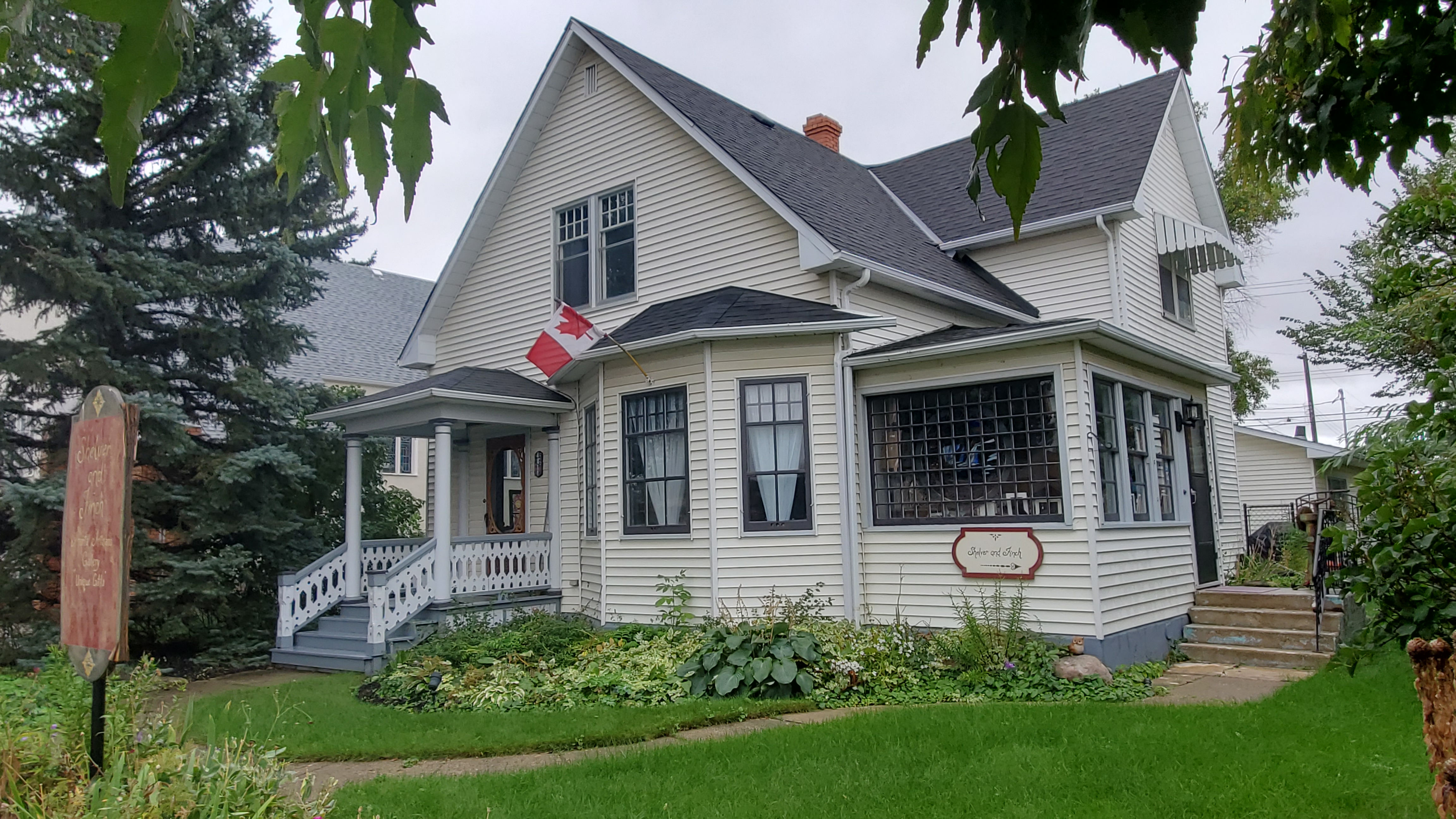
View of the Dr. McMillan Residence from the south, showing the main, residential entrance and the secondary, clinic entrance. Source: Historic Resources Management, Alberta Arts, Culture and Status of Women, 2024.
On Second Street West, at the western fringes of Claresholm’s downtown district, beside a church and amongst several more recent commercial buildings, stands the Dr. McMillan Residence. The house has provincial heritage significance for its association with the provision of medical services in Alberta and for its design, being a combination of private, residential space and professional, medical clinic space.
Written by: Ronald Kelland, Historic Places Research and Designation Program
Remembrance Day, November 11, is the day Canadians honour our military personnel and memorialize those who gave their lives while in military service. While honouring all Canadian service personnel this Remembrance Day, RETROactive is drawing particular attention to a geographical feature named to commemorate two cousins who were casualties of the First World War.
Near the Alberta/British Columbia boundary, 55 kilometres ENE of Grande Cache is a mountain known as Mount May; its two peaks are named George Peak and Francis Peak. The mountain and its peaks are named for two cousins, George and Francis May of Ottawa, both of whom were casualties of the First World War.
Francis May
Francis Loren May (frequently misspelled Francis Lorne May) was born on August 14, 1894, at Ottawa to William Chaney May and Susan Margaret May (née Story). William May was a partner in the family firm George May and Sons, a leather goods and saddlery store on Rideau Street. In 1915, Francis was living with his parents at 155 Gilmour Street in Ottawa. Described as being nearly six feet in height and with hazel eyes, a ruddy complexion and light brown hair, he was a member of the Ottawa Ski Club and the Ottawa Canoe Club and, during his school years, he spent two years with the Ottawa Collegiate Institute Cadets. He tried to enlist for service with the Canadian Expeditionary Force in 1914 but was not accepted due to an attack of appendicitis. He did enlist for service at Ottawa on February 22, 1915. His attestation papers list his employment as clerk, and he may have been employed in the family firm or with the Dominion Government. Francis had worked with the Dominion Land Survey, notably in northeastern Alberta in 1912 as an axeman in the surveying party of George McMillan, DLS. It is possible that the May River, which was partially surveyed and named by McMillan in that year, may have been named for Francis.
Editor’s note: The banner image above is courtesy of the Glenbow Library and Archives Collection, Libraries and Cultural Resources Digital Collections, University of Calgary.
Cowritten by: Fraser Shaw, Heritage Conservation Advisor and Ronald Kelland, Geographical Names Program Coordinator
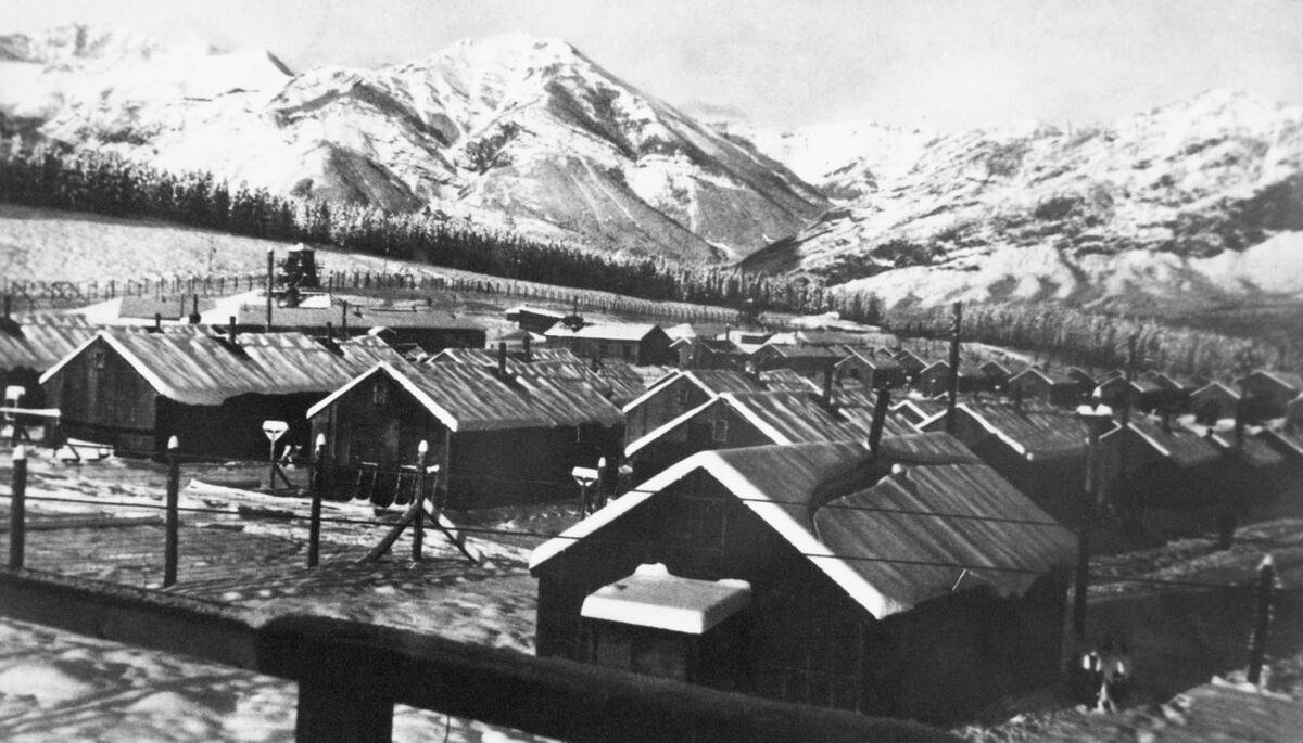
A panoramic 1945 photograph shows a snowbound mountain landscape in the grip of winter. Plumes of smoke rise from rows of tarpaper-covered buildings huddled behind barbed wire fences and guard towers. This is Camp 130, one of a series of Prisoner of War (POW) camps established across Canada during the Second World War. Outside the prisoners’ compound is a small, single-story log cabin occupied by the camp commandant. Built in 1936, the “Colonel’s Cabin” was protected as a Provincial Historic Resource in 1982 as one of few remaining structures in Alberta directly linked to the internment of prisoners of war and to recognize the site’s earlier association with the Kananaskis Forest Experimental Station.
Camp 130 Prisoner of War Camp, winter 1944 or 1945. Source: Glenbow Library and Archives Collection, Libraries and Cultural Resources Digital Collections, University of Calgary, CU1128370 (NA-4824-2os).
During the Great Depression, Canada’s middle-class, political and economic elites were concerned about the large number of unemployed men roaming the country and how that long-term unemployment might result in moral degradation, petty criminality and the fostering of revolutionary communist ideology. Under pressure from religious organizations and municipal and provincial governments, the Dominion government established a series of temporary work camps for single, unemployed men to be administered by the Department of National Defence. By 1936, camps had been established at Acadia, New Brunswick; Valcartier, Quebec; Petawawa, Ontario; Duck Mountain, Manitoba; and Kananaskis, Alberta. Ostensibly created to engage unemployed and homeless men in work that was seen as being necessary for their physical, psychological and spiritual betterment, the camps also kept these unemployed, transient men out of sight and far from transportation routes and urban centres.
Written by: Ronald Kelland, Historic Places Research and Designation Program
Recently, some new Municipal Historic Designations in the Crowsnest Pass, Trochu and Grande Prairie have been added to the Alberta Register of Historic Places. These resources have been deemed by their municipality to be of significant heritage value to their community. Like Provincial Historic Resources, municipally designated properties are protected under the Historical Resources Act and qualify for conservation grants from the Heritage Preservation Partnership Program.
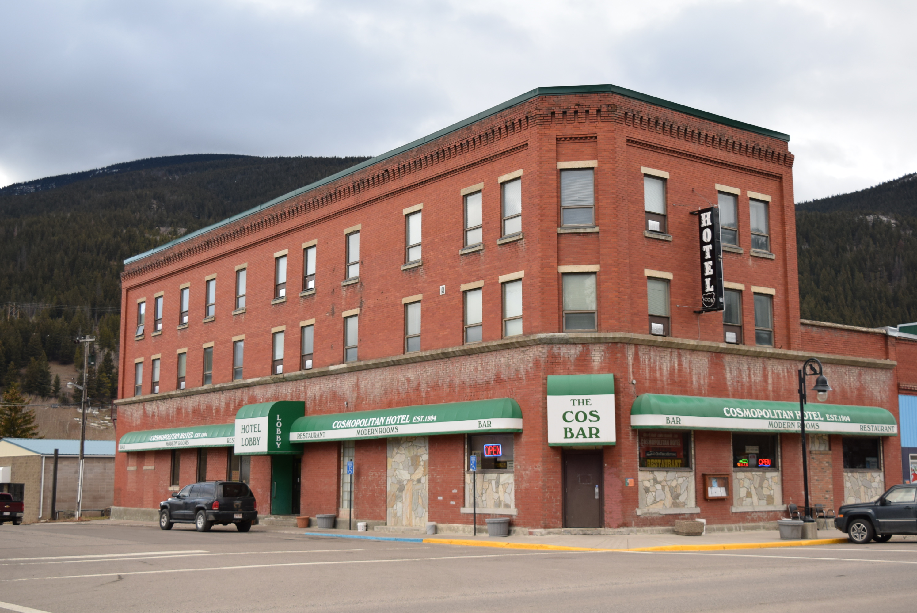
Cosmopolitan Hotel(Crowsnest Pass – Blairmore)
The Cosmopolitan Hotel is a three-story brick building. Its heritage value lies in its: association with the urban and commercial development of the former mining town; for its design; and for its position as a community landmark. Like many communities in their early days, Blairmore’s earliest buildings were simple, wood-frame structures, which were highly susceptible to fire. The original, wood-frame Cosmopolitan Hotel burned down in 1912, along with much of Blairmore’s commercial district. The hotel was rebuilt as a substantial, 50-room brick structure later that same year.
Although still a simple and understated structure, it affects an impressively solid appearance and has some ornamental details, such as the corbelled parapet that were common on commercial buildings of the period. Located on a corner lot on what was Blairmore’s most important intersection, the Cosmopolitan Hotel has long been a significant landmark in the Crowsnest Pass. Being located across the street from the Blairmore Bandstand, which was a favoured location for community events, miners’ union rallies and strikes, the Cosmopolitan Hotel was often the backdrop of those events, making it a significant focal point for the community.
The Cosmopolitan Hotel was designated as a Municipal Historic Resource in 2016 and was listed on the Alberta Register of Historic Places in early 2024.
Cosmopolitan Hotel from the southwest, November 2018. Source: Historic Resources Management, Arts, Culture and Status of Women.
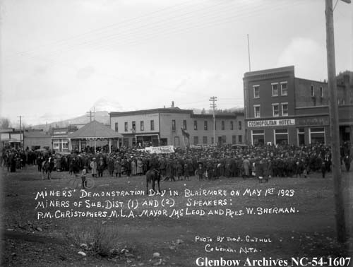
Miners’ Union Rally at the Blairmore Bandstand with the Cosmopolitan Hotel in the background, May 1, 923. Source: Glenbow Archives, NC-54-1607.
Editor’s note: The banner image above, awarding of a Dominion Day track trophy at the Blairmore Bandstand, is courtesy of the Crowsnest Museum and Archives.
Written by: Ronald Kelland, Historic Places Research Officer
A well-known landmark in the Crowsnest Pass has recently been designated as a Provincial Historic resource and is now listed on the Alberta Register of Historic Places.
View of the Blairmore Bandstand from the east, showing its wooden construction and prominent position along Blairmore’s main commercial roadway, June 2021. Source: Historic Resources Management, Alberta Arts, Culture and Status of Women.
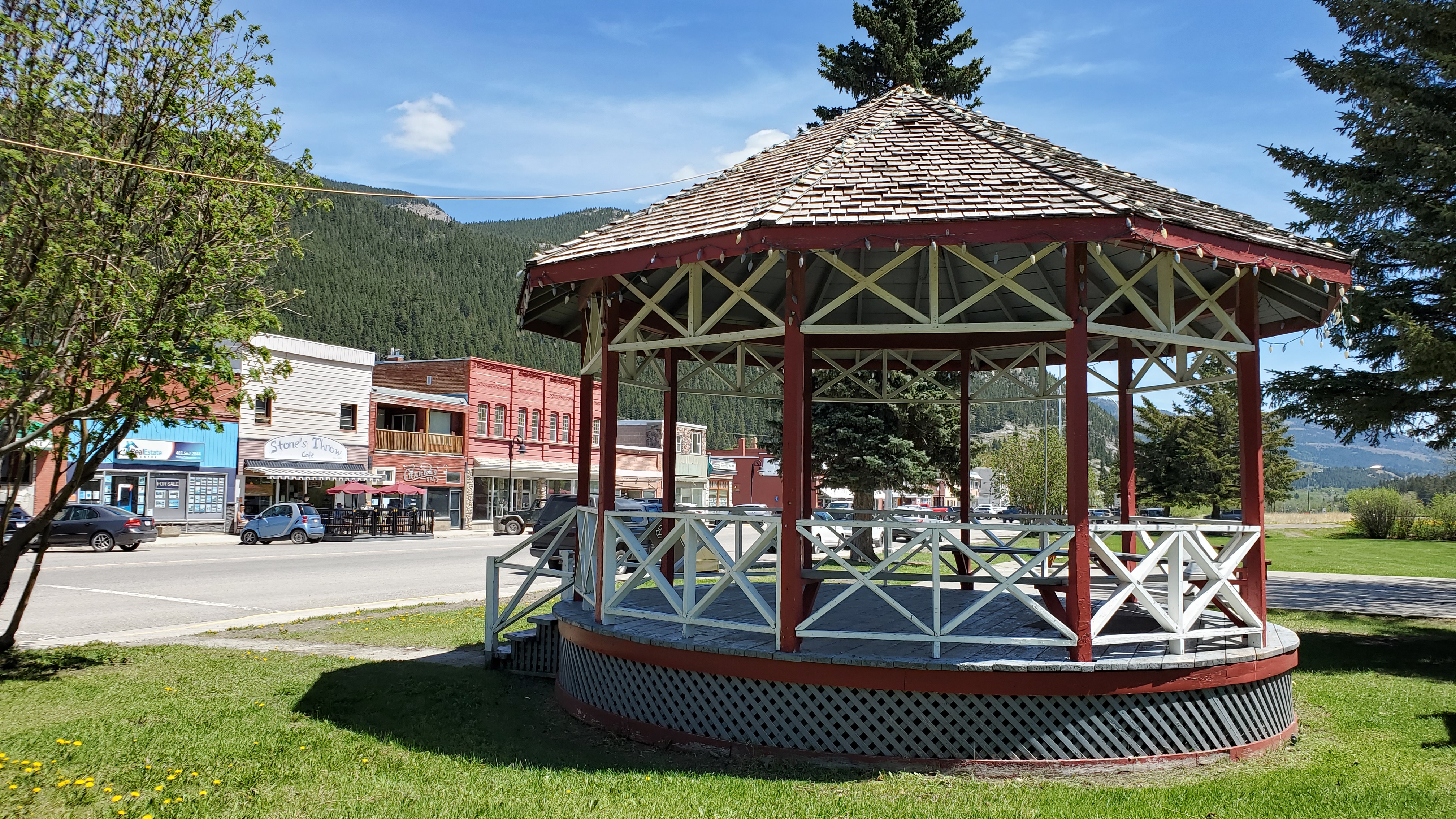
On your drive through the Crowsnest Pass, if you were to pull off Highway 3 and travel down the streets of the communities that make up the municipality you will see historic buildings that harken back to the boom periods of these coal mining towns. One structure that you may miss is a small bandstand in the community of Blairmore situated in a green space between 20th Avenue and the Canadian Pacific Railway line. It may be an unassuming structure, but the Blairmore Bandstand is one of the most significant sites in the Crowsnest Pass – a community landmark and a symbol of hard-won workers’ rights and the labour movement of the 1920s and 1930s.
The Blairmore Bandstand is typical of such structures. Built of wood, the bandstand consists of a raised, circular platform with railings and interior benches under an eight-sided, peaked roof with flagpole. Bandstands were once a common and important fixture in many Alberta communities. Associated with Victorian and Edwardian Age beliefs about the healing and restful benefits of urban green spaces, education and wholesome entertainment, bandstands were often the centrepiece of urban parks, where they were used for public events such as concerts and speeches. Being situated in publicly accessible spaces also leant their use as rallying points for social movements and protests.
Written by: Ron Kelland, Historic Places Research and Designation Program
Place names are an integral part of cultural heritage. In recognition of National Indigenous Peoples Day, the Geographical names Board of Canada has released a dataset of Indigenous place names. The dataset contains about 20,000 names confirmed or reasonably believed to be of Indigenous origin, First Nations, Inuit or Métis. The names have been pulled from the Canadian Geographical Names Database, which is populated with toponymic information from the provincial and territorial naming authorities.
The dataset can be viewed online and is also available with other accompanying documentation from the Government of Canada’s Open Government portal. It can be downloaded in CSV, KML and SHP formats as well as a Web Map Service. Toponomy is an ever changing field with new names being adopted and new knowledge of existing names being discovered. Moving forward, the dataset will be updated weekly to capture these additions and changes. The dataset is freely accessible, but is subject to the Government of Canada’s Open Government License.
Screenshot of the Indigenous Place Names Dataset web viewer. Source: Natural Resources Canada, 2022.
Written by: Ron Kelland, Historic Places Research Officer
Recently, some new Municipal Historic Designations have been added to the Alberta Register of Historic Places. These resources are have been deemed by their municipality to be of significant heritage value to their community. Like Provincial Historic Resources, municipally designated properties are protected under the Historical Resources Act and qualify for conservation grants from the Heritage Preservation Partnership Program.
Of the most recent Municipal Historic resources designations added to the Register, three of them are located in the Town of Okotoks.
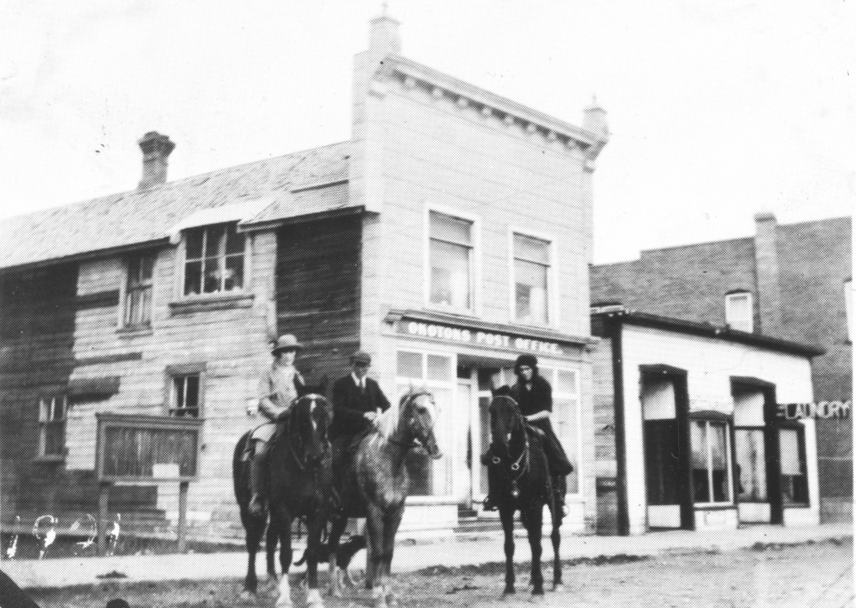
Okotoks Post Office
The Okotoks Post Office is a two-storey wood frame building with a boom town façade and is clad in pressed metal siding resembling a stone pattern. It is centrally located in Okotoks on North Railway Street (formerly Macleod Trail). The post office building is amongst the town’s earliest buildings and was a focal point of the community, being located across from the Canadian pacific Railway station. The building was constructed in 1890 by Herbert Bowen, a local general merchant and post master for the community. When John Paterson bought the store in 1892, he also became the postmaster. The building was the site of the post office from 1891 to 1900, and again from 1907 to 1937. The heritage value of the Okotoks Post Office is due to its association with the town’s early development, being an anchor business and service that the community would grow around. It is also significant for its association with George Paterson, son of John Paterson, who continued in his father’s role of merchant and postmaster and was a noted community member, serving as school board trustee and mayor and belonged to numerous community organizations. The building is also architecturally significant as a representation of an early-twentieth century commercial establishment.
Okotoks Post Office, December 2019 showing the pressed metal siding and boomtown façade. Source: Town of Okotoks.
Okotoks Post Office, 1921. Source: Okotoks Museum and Archives.
Written by: Ron Kelland, Geographical Names Program Coordinator
In July 2021, Canada is marking Historic Places Day, or Days as the case may be. First declared in 2017, Historic Places Day is an initiative of The National Trust of Canada as an opportunity to highlight historic places across Canada, to tell their stories and encourage Canadians to learn about, experience and interact with them to foster a better appreciation of the important role these places have in the lives of Canadians and how they impact the quality of life in our communities.
Historic places take many forms, from old and grand public buildings and monuments to small and homey bungalows and farmhouses, to workers cottages, archaeological and paleontological sites, museums and cenotaphs. With summer now here and people looking for opportunities to enjoy the outdoors, we thought it opportune this year to feature some of Alberta’s parks and outdoor public spaces that have been designated as historic resources. So, grab your walking shoes or hiking boots, bring your camera and lots of water, and let’s explore some these historic parks across the province.
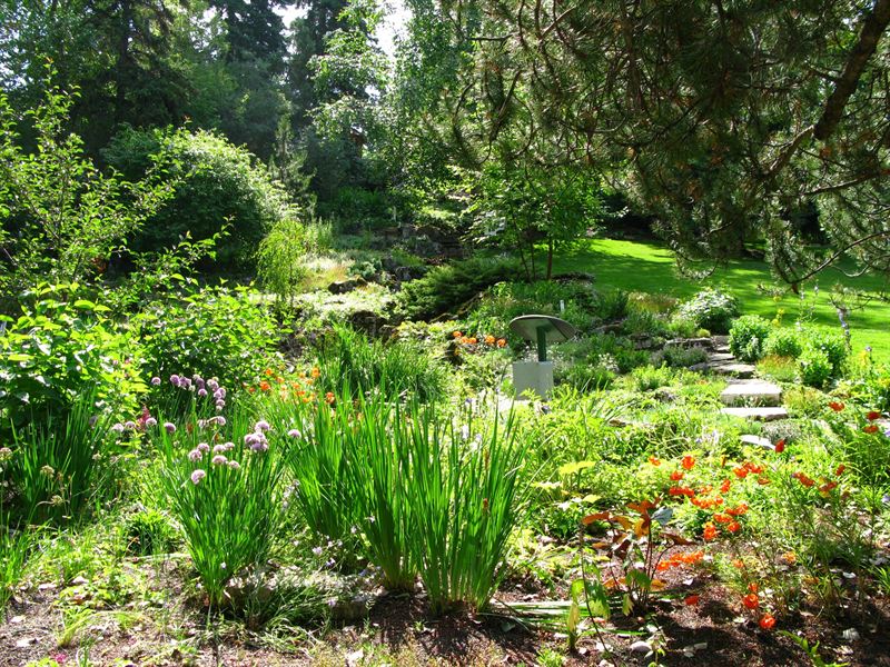
Located adjacent to Calgary’s Union Cemetery, the Reader Rock Garden is an early twentieth-century naturalistic garden composed of rocks, primarily local sandstone; trees; water features; and paths. The garden was designed by William Roland Reader, superintendent of parks and cemeteries for the City of Calgary from 1913 to 1942. Reader was heavily influenced by the City Beautiful movement, which advocated for the inclusion of well-designed green spaces in urban environments. Under Reader’s leadership, Calgary saw the establishment of many parks, playgrounds, golf courses and tennis courts around the city and the planting of trees along city streets. Reader created the Rock Garden as a semi-private park, it was located around the superintendent’s cottage, now a reconstructed elements in the park, and as a living, laboratory where he experimented with thousands of varieties of plants. Reader’s botanical experiments and meticulous observations influenced horticulture across North America through his writings and the distribution of seeds.
Written by: Ron Kelland, Geographical Names Program Coordinator
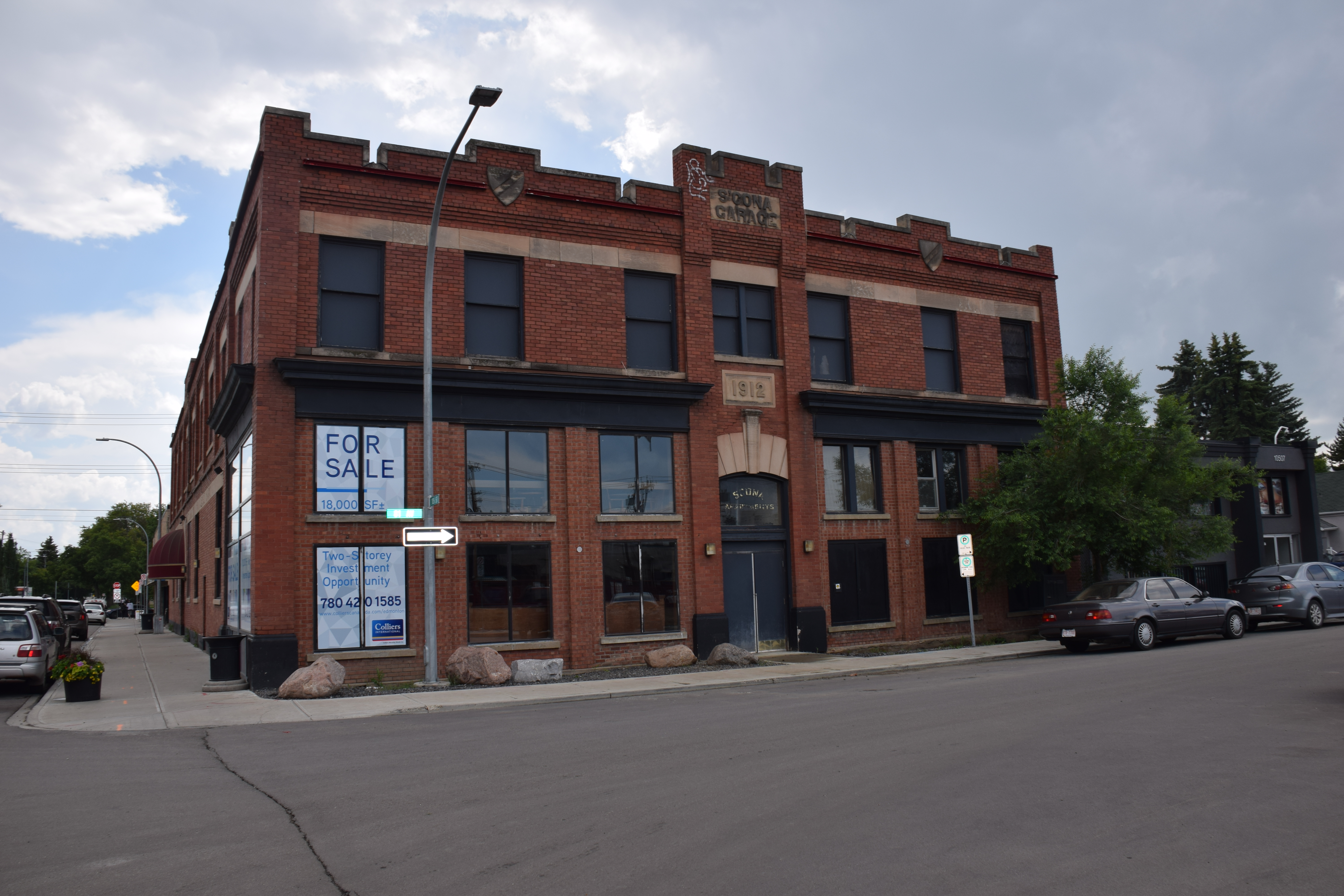
A well-known anchor building in Edmonton’s Old Strathcona Provincial Historic Area has recently been designated as a Provincial Historic resource. And it’s also now listed on the Alberta Register of Historic Places.
Front (north-facing) façade of the Strathcona Garage showing some of the building’s character-defining elements, notably the crenellated parapet roofline, escutcheons and the contrasting ornamental highlights (lintels, sills, name and date stones), 2019. Source: Alberta Culture, Multiculturalism and Status of Women.
The Strathcona Garage is located in Edmonton’s Old Strathcona neighbourhood on the corner of lot at 81 Avenue and 105 Street. Its heritage significance rests in its association with the early automobile industry in Alberta. It is a significant and rare remaining example of a building from the early twentieth century designed and built specifically for the era’s fledgling, but rapidly growing automobile sector.
Written by: Ron Kelland, Geographical Names Program Coordinator
At an online event on March 8, 2020, Seamus O’Regan, the Minister of Natural Resources Canada launched Recognizing Women with Canadian Place Names: Women on the Canadian Landscape. This interactive, digital map was developed by the Geographical names Board of Canada to highlight approximately 500 places and geographical features in Canada that are named for women.
Screenshot of the “Recognizing Women with Canadian Place Names” Interactive map. Source: Natural Resources Canada.
March 8 was International Women’s Day; a day acknowledged around the world to raise awareness of issues facing women, such as gender equity, and to celebrate the social, cultural and political achievements that have been made by women to their communities, regions and nations. The map was launched on that day as part of those annual celebrations.
Through history, the recognition of women has tended to be forgotten. For generations, women have been largely voiceless in history; overlooked by default and design. The essential domestic role of settler women has not been discussed to the same extent as the work of their husbands, fathers and brothers breaking the land, even though these women toiled and suffered just as men had. Even women who were admitted to the professional, scientific or professional world have often seen their accomplishments ignored or downplayed in favour of those of their male colleagues. The same trends are found in the world of cartography and place naming.