
In 1917, surveyor and mountaineer Arthur O. Wheeler of the Interprovincial Boundary Survey wrote that “in a valley surrounded by towering peaks, lies Upper Kananaskis Lake, a large sheet of deep-blue water of irregular shape, dotted with heavily-timbered islands.” The lake, as described by Wheeler, no longer exists, its shape has changed and its islands are mostly gone.

Mountain Legacy Project, WHE14-6. The Mountain Legacy Project is based at the School of Environmental Studies, University of Victoria, Victoria, BC. For more information, go to mountainlegacy.ca, or email mntnlgcy@uvic.ca.
Historic maps show these islands, four of which are usually named – Cressy, Hawke, Hogue and Pegasus. A smaller island located due east of Pegasus Island, typically left unlabelled, was known as Aboukir. A sixth island, located east of and between Hawke and Hogue Island, is sometimes identified as Schooner Island, based on its appearance with trees resembling masts. Today, only Hawke and Hogue Island rise from the lake, mere shadows of their former selves. At low water levels, Cressy Island, and possibly the others, may reappear. Being wiped from maps so many decades ago, few visitors realize the lake was once dotted with islands. Their names reveal a lot about the world view of Canadians when they were named during the First World War.
![Interprovincial Boundary Commission map showing Upper Kananaskis Lake and Cressy Island, Hawke Island, Hogue Island and Pegasus Island. The smaller, unnamed island east of Pegasus Island is likely Aboukir Island and the small island east of and between Hawke and Hogue is likely Schooner Island. Source: Office of the Surveyor General. Sheet No. 9A [map]. Scale 1:62,500. In](https://albertashistoricplaces.com/wp-content/uploads/2016/07/boundary-map.jpg)
The Naming of the Islands – The Interprovincial Boundary Survey and the First World War
The islands of Upper Kananaskis Lake received their names during the surveying of the boundary between Alberta and British Columbia, which was occurring during the First World War. The survey named many features on the maps they produced of the area around the provincial boundary. While many historic fur trade and exploration names were retained, new names were also adopted. The Geographic Board of Canada saw the survey and mapping of the region as an opportunity to honour Allied military and political leaders and commemorate events, particularly British naval campaigns and lost vessels. In 1917, the Geographic Board of Canada set aside a region along the boundary between Bow Valley and Crowsnest Pass for commemorative war names. The idea was inspired by the Thousand Islands in the St. Lawrence River, where groups of islands had been thematically named commemorating the War of 1812, notably the Lake Fleet group of islands, which had been named for the naval vessels on the Great Lakes during the conflict. In November 1917, the Geographic Board of Canada compiled a list of British naval vessels for which geographical features might be named. While most of these vessels were participants in the Battle of Jutland (more on that in a future blog post), five old and outdated battle cruisers were listed – HMS Pegasus, HMS Cressy, HMS Aboukir, HMS Hogue and HMS Hawke. The names of these ships were soon bestowed upon the islands of Upper Kananaskis Lake.
Pegasus Island
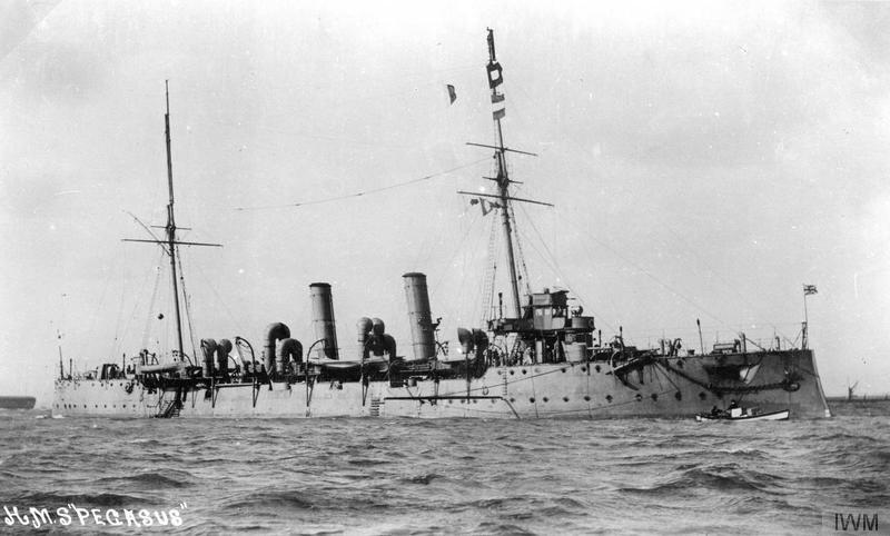
Imperial War Museum, © IWM (Q 74504)
This island was named for HMS Pegasus. A Pelorus-class protected cruiser launched on March 4, 1897. Plagued with boiler problems, she was withdrawn from service in 1904 and scheduled for scrapping, but was reprieved and sent back into active service. At the start of the First World War, Pegasus was patrolling the coasts of Africa.
On September 20, 1914, HMS Pegasus was alone in Zanzibar harbour due to boiler and engine problems when she was surprised by the German light cruiser SMS Königsberg, which began firing from a considerable distance away. Pegasus returned fire, but, outgunned and outranged, failed to hit the German vessel. The Pegasus was immobilized within twenty minutes and, beginning to sink, was left to her fate by the German cruiser. Thirty-eight of the British ship’s crew were killed and 55 wounded in the engagement.
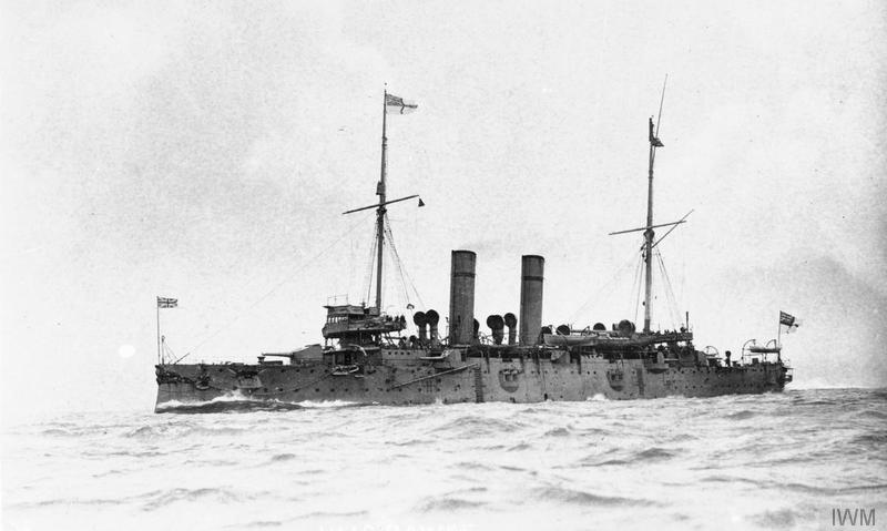
Aboukir Island, Hogue Island, and Cressy Island
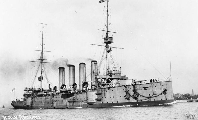
She was named for the Battle of Aboukir Bay, a decisive British naval victory over Napoleon in 1798. Aboukir Island in Upper Kananaskis Lake was named for this vessel.
Imperial War Museum, © IWM (Q 75321)
These islands are all named for Cressy-class armoured cruisers built for the Royal Navy around the turn-of-the century. At the start of the war, these vessels were on the reserve list or were being used as training ships. They were brought back into regular service and, although crewed with inexperienced personnel, were assigned to patrols on the North Sea between Great Britain and mainland Europe. On September 18, 1914, concerned about the age of the ships, their inability to maintain the speed necessary to avoid submarines and their inexperienced crews, First Lord of the Admiralty Winston Churchill recommended the immediate withdrawal of the three ships from the area. Royal Navy leadership agreed in principle, but insisted the ships remain in service until the new Arethusa-class cruisers, then under construction, became available – a decision that would have fateful consequences.
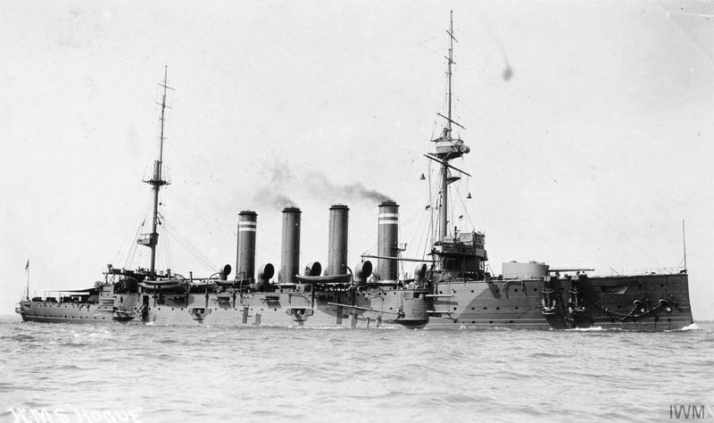
She was named for the Battle of La Hogue, a 1692 naval engagement where the English and Dutch destroyed the remnants of the French fleet that had survived the Battle of Barfleur a few days before. Hogue Island in Upper Kananaskis Lake is named for this vessel.
Imperial War Museum, © IWM (Q 75320)
Early in the morning of September 22, 1914, Cressy, Aboukir and Hogue were steaming, in a straight line, without their destroyer escort, which had been forced into port by bad weather. The ships were sighted by German submarine U-9, which closed in and attacked at 6:20am. HMS Aboukir was torpedoed first, sinking within 30 minutes. Believing Aboukir had struck a mine, the commanders of HMS Cressy and HMS Hogue slowed to pick up survivors. At 6:55am, the Hogue was struck by two torpedoes and sank in about ten minutes. As she was sinking, Hogue fired on the submarine, but failed to score a hit. Cressy was also struck by a torpedo, which did minimal damage, and engaged in short battle with the U-boat before being struck by a second torpedo, sinking in about ten minutes. Casualty numbers vary between sources, but it appears that 837 survived and about 1,460 men went down with the three ships.
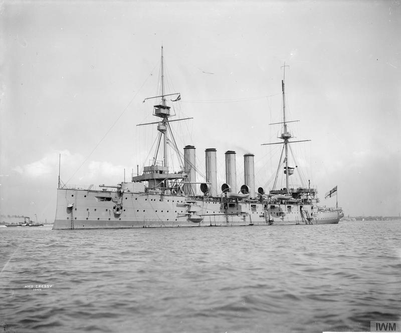
Symonds & Co. Collection, Imperial War Museum, © IWM (Q 38576)
The loss of three armoured cruisers in one short engagement was a shock and an embarrassment to the Royal Navy. A number of admirals and captains were disciplined and demoted for their role in the debacle and Winston Churchill, despite his recommendation to withdraw the ships just a few days prior, was roundly criticized. The sinkings also affected tactics. Although naval captains had been recommended to travel in zig-zag lines to confuse submarines, most did not believe in the effectiveness of the strategy. Cressy, Aboukir and Hogue had been steaming in a straight line when U-9 attacked. From this point on, straight-line steaming was forbidden and zig-zagging made mandatory in or near enemy waters. Furthermore, while it may have seemed foolhardy for Hogue and Cressy to stop and pick up survivors when there may have been an enemy submarine in the area, their captains were following standard procedure at the time. After the sinkings, capital ships (cruisers and battleships) were forbidden to expose themselves to this risk. Rescuing of survivors was delegated to smaller vessels.
Hawke Island
Imperial War Museum, © IWM (Q 75331)
This island is named for HMS Hawke. An Edgar-class protected cruiser launched on March 11, 1891. She became a training ship in 1904 and rejoined the fleet in 1907. Prior to the war, HMS Hawke was best known for colliding with RMS Olympic (sister ship of the Titanic) on September 20, 1911, causing significant damage to both ships. Repaired, Hawke re-entered service and was assigned to patrols in the North Sea. After picking up mail on October 15, 1914, HMS Hawke began steaming in a straight line to rejoin the cruiser group. At 10:30am, she was struck by a torpedo from U-9, the same U-boat that had sunk the Aboukir, Cressy and Hogue three weeks before. The Hawke quickly capsized and sank, taking 524 of her crew with her.
The islands of Upper Kananaskis Lake were named to commemorate the loss of these five vessels and to honour the sacrifice of the crew that went down with them. Interestingly, although the names were recommended by the Geographic Board of Canada and appeared on official federal government maps, including the 1917 boundary commission maps and a 1926 Department of the Interior map (Sectional Sheet No. 114), they do not seem to have been adopted as official names and are not listed in the 1928 Geographic Board of Canada publication Place-Names of Alberta.
The Kananaskis Dam and the Flooding of the Islands
The official standing of the names became a moot point in the 1930s. In the early 1930s, Calgary Power (now TransAlta Utilities) built a log dam between the Upper and Lower Kananaskis Lakes to raise the level of the upper lake. The size of the dam, and the lake, was increased again in 1942. The construction of these dams raised the surface of the lake enough to completely submerge most of the islands, leave only small remnants of two of them above the surface. George Pocaterra, a prominent rancher, guide and general adventurer in the Kananaskis and Highwood region, eulogized the lake and its landscape, remembering that the “most beautiful mountain scenery in the world, as far as I am concerned, was at these lakes, but now it is completely spoiled by the power dams, and the drowning of the marvellously beautiful islands.”
For some reason, despite the fact that most of the islands had ceased to exist, being submerged within the lake, in 1957, the names Aboukir Island, Cressy Island, Hawke Island, Hogue Island and Pegasus Island were suddenly adopted by federal naming authorities and are included in the 1958 list of official place names in Alberta. Finally, in 1966, on advice from the Geographic Board of Alberta, the federal board, now called the Canadian Permanent Committee on Geographical Names, rescinded the names Aboukir Island, Cressy Island and Pegasus Island, retaining only Hawke Island and Hogue Island as names for the two remaining islands.

Mountain Legacy Project, BOO112.
The Mountain Legacy Project is based at the School of Environmental Studies, University of Victoria, Victoria, BC. For more information, go to mountainlegacy.ca, or email mntnlgcy@uvic.ca.
Today, the island dotted surface of Upper Kananaskis Lake has largely faded from memory, existing only in archival photographs. Hawke and Hogue Island are all that remain of the five islands named to demonstrate Canada’s sense of duty to the Empire and commitment to the war effort by naming elements of the Kananaskis landscape for five First Word War Royal Navy ships and their unfortunate crews.
Written by: Ron Kelland, Historic Places Research Officer and Geographical Names Program Coordinator.
Sources and Additional Resources:
Armstrong, Christopher and H. V. Nelles, Wilderness and Waterpower: How Banff National Park Became a Hydroelectric Storage Reservoir (Calgary: University of Calgary Press, 2013).
Canadian Board on Geographical Names. Gazetteer of Canada: Alberta (Ottawa: Government of Canada, 1958).
Canadian Permanent Committee on Geographical Names. Gazetteer of Canada: Supplement No. 7, January to June 1966 (Ottawa: Government of Canada, 1966).
—. Gazetteer of Canada: Alberta (Ottawa: Government of Canada, 1988).
Daffern, Gillean. Kananaskis Country Trail Guide: Volume 1, 3rd ed. (Calgary: Rocky Mountain Books, 1997)
Department of the Interior. Topographical Survey of Canada. Sectional Sheet No. 114: Calgary, Alberta, West of Fifth Meridian [map]. Scale 1:190,080 [1 inch to 3 miles]. (Ottawa: Government of Canada, 1926).
Geographic Board of Canada. Place-Names in the Thousand Islands, St. Lawrence River (Ottawa: Government of Canada, 1910).
—. Place-Names of Alberta (Ottawa: Government of Canada, 1928).
Milford, Darren, “Loss of HMS Aboukir, Cressy and Hogue,” World War I Naval Combat. http://www.worldwar1.co.uk/cressy.htm (accessed 10 July 2015)
Office of the Surveyor General. Report of the Commission Appointed to Delimit the Boundary between the Provinces of Alberta and British Columbia: Part 1, From 1913 to 1916 [and Atlas] (Ottawa: Government of Canada, 1917).
—. Sheet No. 9A [map]. Scale 1:62,500. In Atlas of the Commission Appointed to Delimit the Boundary Between the Provinces of Alberta and British Columbia: Part 1, From 1913 to 1926. (Ottawa: Government of Canada, 1917).
Oltman, Ruth, My Valley: The Kananaskis (Calgary: Rocky Mountain Books, 1997).
Wikipedia Contributors. “HMS Aboukir (1900).” Wikipedia, The Free Encyclopedia. https://en.wikipedia.org/wiki/HMS_Aboukir_(1900) (accessed June 30, 2015).
—. “HMS Cressy (1899).” Wikipedia, The Free Encyclopedia. https://en.wikipedia.org/wiki/HMS_Cressy_(1899) (accessed June 30, 2015).
—. “HMS Hawke (1891).” Wikipedia, The Free Encyclopedia. https://en.wikipedia.org/wiki/HMS_Hawke_(1891) (accessed June 30, 2015).
—. “HMS Hogue (1900).” Wikipedia, The Free Encyclopedia. https://en.wikipedia.org/wiki/HMS_Hogue_(1900) (accessed June 30, 2015).
—. “HMS Pegasus (1897).” Wikipedia, The Free Encyclopedia. https://en.wikipedia.org/wiki/HMS_Pegasus_(1897) (accessed June 30, 2015).

thanks for the insight of geographical name changes = and the historical background.
You are very welcome Peter. The stories behind many of Alberta’s place names are quite interesting and fascinating. I am glad to hear that people are enjoying reading these histories as much as I enjoy researching and writing them. I hope you continue to check back for more blog posts about Alberta’s heritage and history.
Having just kayaked Upper Kananaskis Lake for the first time, we were curious about the two islands and our curiousity led us to this blog post. Apparently we landed on Hogue Island, and paddled between Hogue and Hawke Islands for the time lapse we did. Thanks for the great background information.
They should have never dammed the lake. They have destroyed the beauty.
Hi nice reading your bllog