45+ Years of Data Management at the Archaeological Survey of Alberta

Whether excavating archaeological sites or surveying the land in search of undiscovered ones, archaeologists create data. That data can take the form of field journals, artifact catalogues, GPS tracks and waypoints, photographs, excavation plans, level records, site forms, and reports. It is often said that for every month spent in the field, an archaeologist will spend a year in the lab and the office processing the field data they collected.

The Archaeological Survey (the Survey) began managing Alberta archaeological sites, research, and mitigation in 1972, with the passing of what is now known as the Historical Resources Act. At the same time, the Survey also became the official provincial repository for most archaeological data. Today the Survey collects and archives data for use by archaeological researchers, consultants, and other stakeholders, and also relies on archaeological data in order to run the historic resources management machinery. Read more

The Swing of Things: Archaeology in Alberta and the Occasional Paper Series

The Archaeological Survey of Alberta is proud to kick-off Occasional Paper No. 38 with a new format and early contributions. Articles in the Occasional Paper Series will now be published online throughout the year, with the final, compiled volume released at the end of the year. Our goal in moving to this rolling release format is to make articles available in a timely manner, while helping to accommodate the schedules of CRM consultants, university students, and other contributors.

Cover of the 2018 Occasional Paper Series. Submissions are welcome.

Occasional Paper No. 38, “The Swing of Things: Contributions to Archaeological Research in Alberta, 2018,” is dedicated to an early member of the Archaeological Survey of Alberta, Milt Wright, whose recent passing was mourned by the province’s archaeological community. The first article in the volume is a tribute to him.

Milt Wright (1952-2017) was an integral member of the Archaeological Survey of Alberta in the 1980s and 90s.

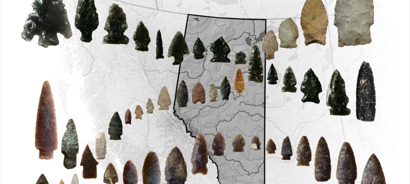
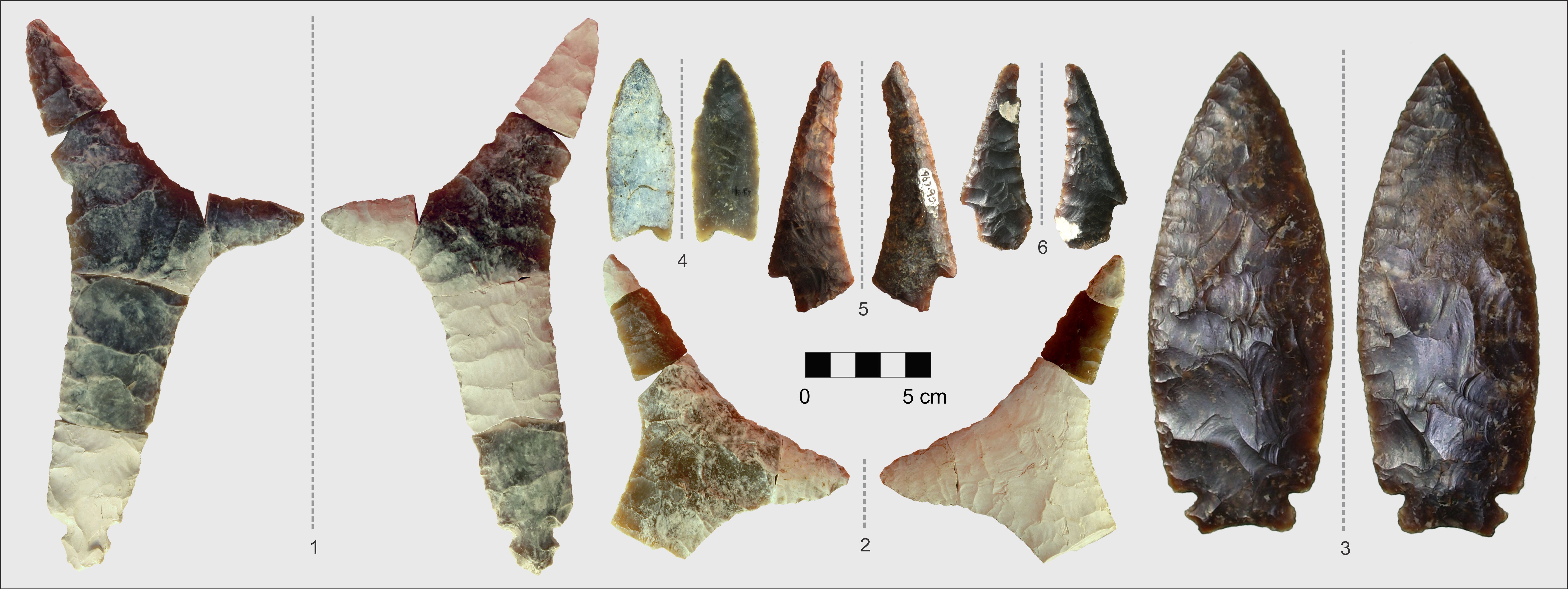
The second paper is an identification guide for Knife River Flint, supplemented by geochemical and mineralogical tests of this important raw material that was used to make stone tools in Alberta.

A sample of Knife River Flint artifacts found in Alberta. Individual artifact photographs courtesy of Eugene Gryba, Shayne Tolman, Bob Dawe, and Todd Kristensen.

The title, “The Swing of Things,” refers to what we hope will be consistent format and content for years to come: each issue will feature papers documenting the multitude of cultural resource management (CRM), avocational, and academic archaeological projects completed in previous years. Interested authors can pitch a paper or idea to the editorial committee. The current and past volumes are available for free download here.

Written By: Eric R. Damkjar, Head, Archaeological Survey of Alberta

After the Flood: Archaeology in Alberta and the Occasional Paper Series

The Archaeological Survey of Alberta is proud to release Occasional Paper Series No. 37 dedicated to historic resources encountered and documented during investigation programs following the June, 2013 flood in southern Alberta. The volume contains 18 articles written by historic resources consultants, university researchers, staff of the Royal Alberta Museum, and members of the Archaeological Survey of Alberta. The flood eroded and blanketed archaeological, palaeoenvironmental, and palaeontological sites; Alberta Culture and Tourism coordinated a series of contracts in 2014, Read more

The Early Years of Archaeology in Alberta

As the summer of 1949 approached, Boyd Wettlaufer, a Master’s student of archaeology at the University of New Mexico, was asked by his Field Director where he wanted to dig for the summer. In a 2008 interview, with Karen Giering of the Royal Alberta Museum, Wettlaufer related how the conversation with his director had transpired:  

 “Boyd,” he said. ‘I think it’s time you did a dig of your own. Where would you like to go?” And I thought of Head-Smashed-In. I said, “Well there’s a buffalo jump up in Alberta I wouldn’t mind taking a look at.” And so, he gave me a couple boxes of groceries and credit card for the gas and the two boys (William Hudgins and Donald Hartle) to help me and sent me off” [1].

Wettlaufer was familiar with the area around Fort MacLeod, having been stationed out of the nearby Royal Canadian Air force base of Pearce during the war as a flight instructor and aerial photographer. It was a member of the local historical society (Boyd and his wife Dorothy plugged their trailer into her porch for electricity [2]), who had first shown him the Read more

The Hardisty Bison Pound

Between 2008 and 2014, five separate archaeological excavations took place at the Hardisty Bison Pound and its associated campsite. These two sites, located across the Battle River from the town of Hardisty, were excavated in response to developments that took place during facility expansions at the Hardisty Terminal.

Bison pounds are a form of communal hunting common on the Plains. They are characterised by a wooden corral with hides draped over the edge. Bison would have been herded into the fenced enclosure to be slaughtered for consumption by the community using the pound. The landforms surrounding the Hardisty Bison pound share distinct features that would have been essential to many communal kills. Many of these features have been introduced in past RETROactive posts, in particular Mike Donnelly and Todd Kristensen’s post on Head-Smashed-In. Most notably, the Battle River valley and the hills surrounding the Hardisty Bison Pound combined to form a funnel that would have acted to concentrate bison herds close to the current location of the terminal. With the addition of drive lanes and buffalo runners luring bison into the trap, these herds would have been driven quite easily into the pound, both to feed people living in the area as well as for production of meat and hide products to trade with people further east in what is now Manitoba and North and South Dakota.

Excavation Block from 2009 excavation at the Hardisty Bison Pound. The pound is located on the far side of the block at the toe of the small hill in the background (Photo Credit:  Matthew Moors, FMA Heritage Inc., Permit 09-020).

Read more

Hunting With a View: Excavations at the Hummingbird Creek Site (FaPx-1) in Alberta’s Central Rockies

In 2009, the Archaeological Survey of Alberta discovered the Hummingbird Creek Site (FaPx-1), an archaeological site rich in stone artifacts, animal remains, and hearth features, in Alberta’s central Rockies. The site resided on a high terrace above Hummingbird Creek and the South Ram River, an ideal location for observing the valley below. Radiocarbon dates from the site’s lower levels indicated it was occupied from between 2,500 – 2,400 years ago, and upper levels dated from 1,000 – 700 years ago. This past August, Timothy Allan (MA student at the University of British Columbia), members of the Archaeological Survey of Alberta, and the Red Deer Archaeological Society returned to FaPx-1 to complete excavations at the site. The team found atlatl (or throwing spear) projectile points, hide scrapers, stone tool debris (flakes), and animal bone. Read more

Connecting the Continent: Stone Tools in Alberta

After a few thousand years, most of the archaeological record in Alberta has been winnowed down to pieces of rock used to make tools. Organic artifacts, structures, and other less durable things generally don’t survive thanks to erosion and decomposition. To maximize the information we can pull from those pieces of stone, the Alberta Lithic Reference Project (ALRP) was formed by a consortium of archaeological consultants, heritage managers, geologists, students, and university researchers. The goals are to accurately and consistently identify the types of raw materials that pre-contact people used to make stone tools. Why is this important? Specific types of rock were traded and moved widely across the continent and serve as valuable indicators of cultural relationships and/or human mobility patterns. Read more

Old as… ?: Dating Archaeological Sites

Knowing the date of an archaeological site is one of the things that makes it most interesting – when were people here?

Two main types of dating are applied to archaeological sites when possible– relative and absolute dating. Relative dating puts sites or artifacts “in order” by simply determining if one event happened before or after another. A common example of relative dating in Alberta is by using Mazama Ash. About 7600 years ago, Alberta was blanketed in ash after the Mazama volcanic eruption. This ash is still sometimes found today in stratigraphic profiles, buried under other deposits of sediment. When this ash is encountered it can be used as a time marker. Anything below it is older than 7600 years and anything found above it is younger than 7600 years.

Example of a buried volcanic ash (also known as tephra) found during archaeological excavation. The ash is the lightest coloured layer in the profile, between 25 and 35 cm below the surface (between the 1 and 3 on the tape measure).

Relative dates can also be obtained using artifact styles. Projectile points are one of the most common types of artifacts used to relatively date sites. Spearpoints represent the oldest projectile point technology and indicate that the site falls within the “Early Prehistoric Period” (11,200-7,500 calendar years before present), dartpoints are representative of the “Middle Prehistoric Period” (7,500-1,350 calendar years before present) and arrowpoints represent the emergence of the use of bow and arrow in the “Late Prehistoric Period” (1,350-250 calendar years before present). Dates can be further refined within each general time period based on the spear, dart or arrow style.

Absolute dating is more specific than relative dating and provides a more exact date (with standard deviation) of when the site or artifact was used. There are several methods of absolute dating but one of the most common methods used by archaeologists is radiocarbon dating. Radiocarbon dating can be used on organic material such as bone or charcoal. A radiocarbon date can be obtained by measuring the amount of Read more

Mountain Movement: How the Rockies Shape Alberta

Most of Alberta’s Rocky Mountains finished uplifting 50 million years ago – they’ve been pouring sediment across the province ever since. The Rockies shaped our water drainage network and, with the help of glaciers, erected the house of silt, sand, and stone that we all live in. The tilt that our mountains built is largely responsible for the development of our prairie soils and modern agriculture. Our mountains have also shaped how cultures interact and move, which has moulded much of our history.

At first glance, the Rockies are imposing – an impressive barrier rising from the foothills like a stony gate. But for thousands of years, people traveled across and within them to trade and acquire goods. Groups in southeastern British Columbia, like the Kootenai, often descended into Alberta’s valleys to hunt bison and other big game. The Kootenai engaged in trade and formalized sport (like the hoop and arrow game) with local Blackfoot, Cree, and other groups. Large caches of meat and hides were then transported back across Read more