
Whether excavating archaeological sites or surveying the land in search of undiscovered ones, archaeologists create data. That data can take the form of field journals, artifact catalogues, GPS tracks and waypoints, photographs, excavation plans, level records, site forms, and reports. It is often said that for every month spent in the field, an archaeologist will spend a year in the lab and the office processing the field data they collected.
The Archaeological Survey (the Survey) began managing Alberta archaeological sites, research, and mitigation in 1972, with the passing of what is now known as the Historical Resources Act. At the same time, the Survey also became the official provincial repository for most archaeological data. Today the Survey collects and archives data for use by archaeological researchers, consultants, and other stakeholders, and also relies on archaeological data in order to run the historic resources management machinery.
As Courtney Lakevold, Archaeological Information Coordinator, pointed out earlier, Alberta is rich in archaeology! Archaeologists have discovered about 40,000 sites in the province during thousands of research projects. In the early decades of the Survey, a lack of technology made the work of managing the data from all those projects slow and labour intensive. As computer technology evolved and became more accessible through the 1980s, 1990s, and 2000s, the Survey has been able to improve data management processes. Keep reading this post to see some of the archaeological data management strategies we have used since the 1970s.
The Early Years – Data Trapped on Paper
Archaeological Site Locations
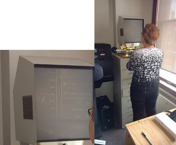
The Archaeological Survey tracks the locations of thousands of archaeological sites. Prior to the 2000s, site locations provided by field archaeologists were mapped by Survey staff using UTM overlay grids on NTS paper maps. Occasionally a map became so worn that it had to be replaced, meaning that every site location had to be redrawn. The image below shows the NTS map (c. 2000) of north Calgary. As described by Eric Damkjar, Head of Archaeology, the process of recording and accessing information about archaeological sites on paper NTS was arduous.

Archaeological Site Data
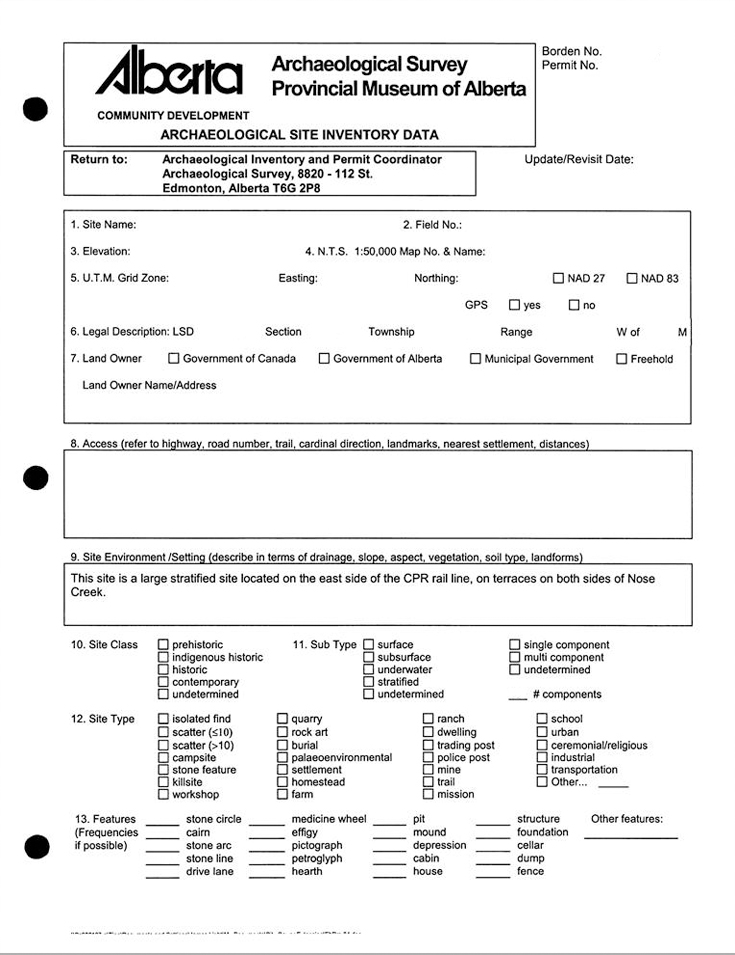
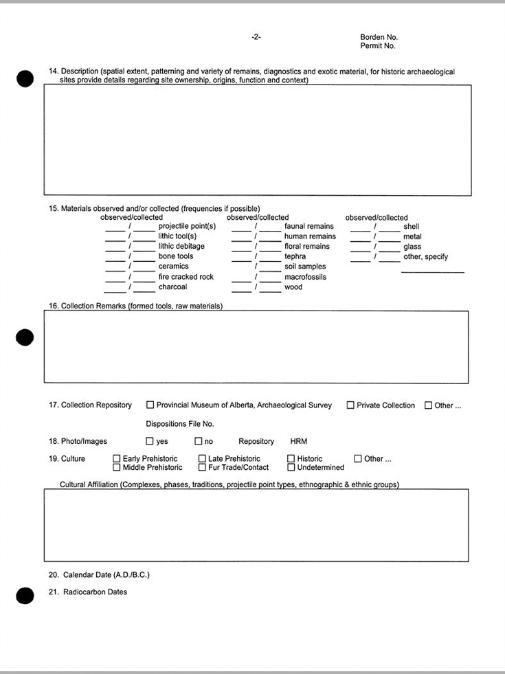
Site data were collected using Archaeological Site Inventory Data Forms (site forms). Prior to the creation of the Survey, institutions undertaking archaeological research, like the University of Calgary and the Glenbow Foundation, each used their own site forms. In 1973 the Survey created a standard 2-page form for the province, as seen below (click for full size).

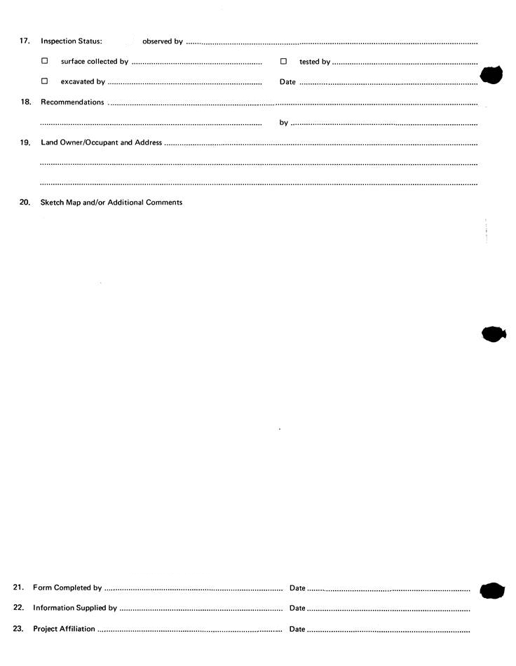
Over decades, archaeologists submitted paper site forms for thousands of archaeological sites. Those paper forms are stored in the Edmonton office of the Survey in our Archaeological Sites Inventory (modern picture below). Each binder in the room represents a portion of a Borden block, and in total they comprise 53,000 site forms. In pre-computer times, to find the site forms you need in the inventory, you would have to find your binder and settle in for a mundane afternoon of page-turning and photocopying.

Archaeological Reports
Every year the Survey reviews and accessions hundreds of technical archaeological permit reports covering research and cultural resource management projects in Alberta. While these reports were always theoretically available to researchers, they suffered the same issues as many unpublished technical archaeological reports, or “grey literature,” in other jurisdictions. The reports contained a wealth of knowledge, but the information was in a sense ‘trapped’ in that it was not synthesized or easily accessible.

Archival Technology
The Archaeological Survey also has a responsibility to archive data for long-term records. In addition to paper copies of archaeological reports that are stored in two separate locations, reports were scanned to microfiche, beginning in the 1980s, and later to microfilm. While the technology may seem outdated now, microfilm is still great archival technology. It is low cost and easily stored, and the film has a life expectancy of hundreds of years. Copies of reports on microfiche and microfilm are stored at three different physical locations.
Overall, management of archaeological data during the paper years was imprecise and laborious. It was especially challenging when the volume of archaeological research surged during Alberta’s boom times. The Survey was primed to make the most of information technology as it became available.
The First Computers
Archaeological Site Data
In 1992 the Survey data managers who were processing and maintaining site data on paper developed their first computer database using FileMaker Pro software. For the first time, field archaeologists were asked to submit electronic database entries along with paper site forms. Subsequently, the site form template was modified to be more compatible with database technology. The form was expanded to four pages. It included many of the same fields as the previous form, such as site type, material type, and disturbance factors, but added new features, such as check boxes, that contributed to data consistency. As a result, Survey staff were better able to search data and respond to research requests. At the same time, site maps and coordinate information, were made mandatory. Unfortunately for the data managers at the Archaeological Survey, site locations were still hand-drawn on paper NTS maps at this time.


Digital Archival Technology
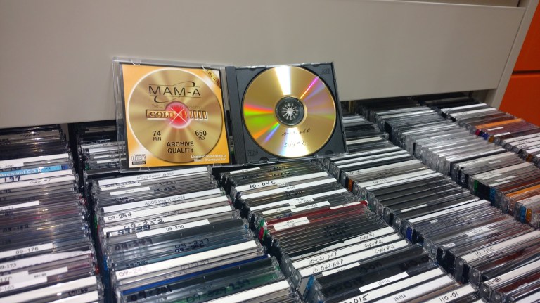
Beginning in the early 2000s, the Archaeological Survey began creating a digital archive. First, the extant paper archive of site forms and reports was scanned. Today digital files, including report PDFs, site form PDFs, digital photos and catalogues, and artifact catalogues, are submitted by field archaeologists on archival-quality gold discs and stored in two different locations. Digital copies of all files are stored on offsite servers. And, because we still want the option to read archaeological reports in a post-apocalyptic world where digital technology no longer works, we still archive microfilm and paper copies of reports.
The GIS Years
In 2003 the Archaeological Survey made a big leap forward and started using geographic information systems (GIS) technology. GIS is a computer system for capturing, storing, checking, and displaying data related to spatial locations on Earth’s surface.
In 2003 the data managers at the Survey first began by taking the locations of all of those archaeological sites previously drawn on paper NTS maps and mapping the coordinates into GIS. It wasn’t always easy, since field archaeologists did not have Global Positioning Satellite (GPS) technology until it was made accessible to consumers in the 2000s, so determining correct locations for sites recorded earlier took additional research.
The Survey also integrated GIS with the existing digital archaeological sites database. This means that all of the data about archaeological sites can now be instantly accessed and queried spatially using GIS software.

Next, the Survey went through the back catalogue of archaeological reports and mapped in GIS polygons of surveyed areas under each archaeological permit, where possible, from 1973 to 2014 (Haukaas and Werner 2016). Reports from earlier permits did not always include sufficient illustrative materials to allow precise mapping of either developments or surveyed areas. Thankfully, many archaeological report submissions from the late 2000s and 2010s contained detailed spatial information, which allowed for considerably more precise mapping. The database currently has the polygons of about 8000 archaeological permits. Since 2014, archaeological consultants and researchers have provided their own polygons of surveyed areas, as well as points representing investigated subsurface tests, excavations, monitored areas, and observed site features (e.g., cabins, stone features). The Survey now has data from about 700 projects submitted since 2014.

Most excitingly, GIS has allowed the Survey to take information that was once stuck entirely within paper files on shelves and create an efficient, visual, accurate and searchable reference. The GIS databases provide a spatial reference to understand archaeological sites and projects contextually. We can understand archaeological sites in local and broader ecological contexts, and we can use an array of imaging techniques to understand current and past landscapes and other ecological factors that may have impacted sites. As regulators, we can find out very quickly if a new development will impact known resources, or if lands have been previously assessed.
Ongoing Challenges
The Archaeological Survey has made significant improvements to data management over the years, thanks in large part to available technologies. However, data management is a fast-paced field with quickly-evolving technologies and, as stewards of sensitive resources, we have to approach new technologies carefully to ensure that information about archaeological resources is safe and secure for the long term.
Written by: Colleen Haukaas, Archaeological Survey, and Courtney Lakevold, Archaeological Survey
Links:
To see our newest site forms, spatial data templates, and other information about data management, see the Archaeological Survey websites here:
References:
Haukaas, Colleen, and J. Jeffrey Werner. 2016. “Development and early results of the Spatial Data Standards for Archaeological Survey and Excavation in Alberta.” http://www.culturetourism.alberta.ca/heritage-and-museums/programs-and-services/archaeological-survey/publications/occasional-papers/docs/2016/spatial-data.pdf

An excellent overview of how “the Survey” recorded data then and now.
Very fine work about the difficulties of setting up, managing, and adapting the realm of data management. I am surprised that no mention was made of the role of the Canadian Heritage Information Network (or C.H.I.N.) or the use of aerial photos and mosaics (required of developers in their impact assessments’ documentation), and assume access to these became too cumbersome over time, or that this information has been lost as the decades have passed.