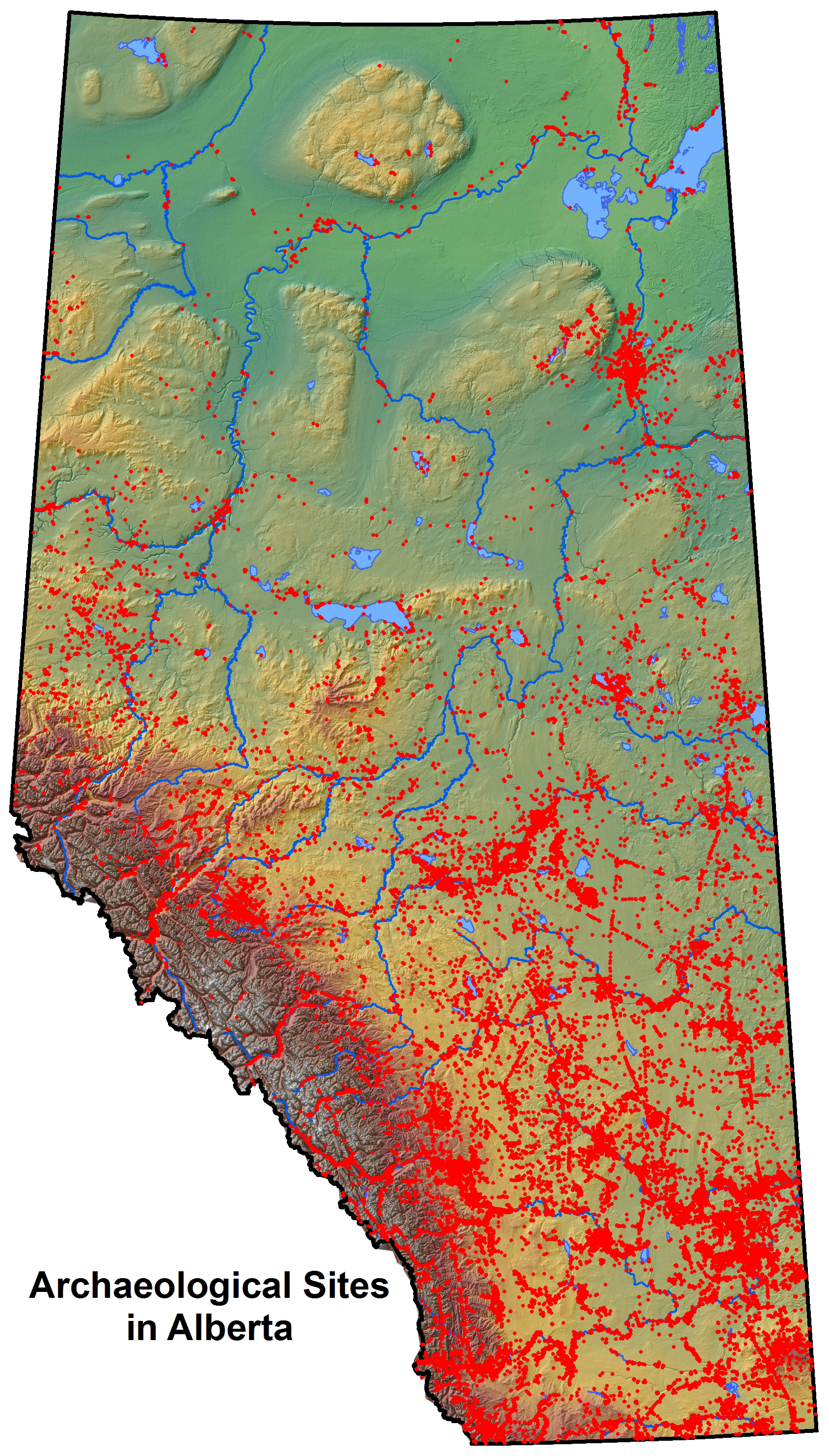
“Putting dots on paper maps”—that’s how Eric Damkjar, Head of Archaeology at the Archaeological Survey Section of the Historic Resources Management Branch, describes his section’s old methods of recording archaeological site locations. In his words, “We have on record approximately 40,000 archaeological sites … We used to manage that information with hand-drawn dots on paper maps, and that’s a very arduous system.” But about ten years ago the branch obtained funding to create a geographic information system (or GIS) for the information—basically a computerised map”. Damkjar, a former consulting archaeologist who says he’s always had a technical bent, “jumped at the chance” to work on this new initiative.
Embracing technology, particularly GIS mapping, has dramatically changed the way that the Archaeological Survey Section regulates development. Indicating the proposed footprint of the development on a computerised map is much easier and more accurate than the old system of pulling out the relevant paper map and laboriously drawing in the footprint by hand. Also, the electronic footprint provides instant access to a variety of related electronic records that formerly had to be retrieved by hand and reviewed on paper.
The potential of electronic mapping and electronic databases of information go far beyond improving the section’s abilities to regulate development. Paper maps indicating the location of 40,000 historic resources—along with archaeological reports numbering in the thousands—were, as one might expect, extremely difficult to access. When reports only existed in paper form, an individual who wanted to do research had to physically go into the basement and pull a report off the shelf. “Our unit,” says Damkjar, “was basically trying to unlock the vault of archaeological information that was sitting there, tied up in paper, and to make it more accessible [not only for] our … regulatory actions, but also for research.” One goal for 2014 is to create a web portal consisting of a mapping viewer that the public can use to access and view information about archaeological sites.
Damkjar is also eager to make the information that has resulted from the regulation of development more readily available. Every year millions of dollars are spent by industry on archaeological studies, because the Historic Resources Management Branch frequently requires industry to do excavations of sites slated for potential development. Since 1973, there have been approximately 7,000 archaeology projects undertaken in the province. “There’s a valid point in wondering what is the point of excavating these sites if you’re not going to learn anything from it”—in other words, if that information is not going to be made more accessible to the public and to scholars, says Damkjar.
Synthesizing work that has been done by digitizing reports and building databases and electronic maps will help Albertans improve their understanding of the “big picture” of the province’s historic resources. “We can now study the distribution of ancient land use across the province,” says Damkjar. “We can look at where in Alberta different sites are distributed—that used to be very daunting when it was in paper.” The ultimate goal, in Damkjar’s view, is to translate, digest, and synthetize the existing information that the province holds on all its historic resources and in so doing, create a “higher level of understanding” of Alberta archaeology as a whole. Significant progress has been made by staff at the section, who have published books and articles aimed at both amateur and professional archaeologists.
The vision Damkjar has is to “create an environment where we can have dynamic links between archaeological site location information [in GIS] … artifact information, and photographs that are submitted in reports and so on, and create a kind of unified electronic environment where researchers, regulatory people like ourselves, and consultants can work from their desktops and look at the full spectrum of information.” Damkjar notes that “there’s still a lot of work to be done on that front”—but that goal is vastly more achievable now thanks to the evolving technology.
Languishing historic downtowns were revived, once again attracting businesses and customers. Modest but beloved churches were repaired to continue to serve their congregations and communities. An exquisite sandstone prairie mansion where history was made, the Lougheed House, was painstakingly restored to become a vital museum and events venue. These were some of the highlights of Tom Clark’s ten-year stint on the Board of Directors of the Alberta Historical Resources Foundation.
Tom applied to join the Foundation’s board while serving on the Clearwater County Council for two terms and while chairing the Nordegg Historical Society (which he still does). His experience working with community groups and addressing heritage conservation concerns prepared him well to fill a spot on the board.
Tom Clark, former Director of the Alberta Historical Resources Foundation.
While the Foundation supports a number of programs, “the big thing was the adjudication of funds that people have applied for over the years for their different projects,” Tom explains. “There is an awful lot in the province…that needs restoration,” he notes. To maintain their integrity, historic places need the injection of funding and technical expertise that the AHRF can bring them.
The Foundation—which gets its money from the Alberta Lottery Fund—provides funding to projects that preserve historical resources or raise awareness of heritage in Alberta. Grants are awarded through three programs: the Heritage Preservation Partnership Program, the Alberta Main Street Program, and the Municipal Heritage Partnership Program. The last two programs are specifically for municipalities, but grants from the Heritage Preservation Partnership Program are available to anyone working to conserve or increase public awareness of a historic resource. They are awarded in five categories: Historic Resources Conservation, Transportation/Industrial Artifact Conservation, Heritage Awareness, Publications, and Research. There are also two scholarships: the Roger Soderstrom Scholarship and the Bob Etherington Heritage Trades Scholarship.
Tom saw a wide range of grant recipients during his time on the board: from “a local ladies’ group that want[ed] to restore the roof of a church” to National Historic Sites such as the Medalta Potteries of Medicine Hat, and the main streets of towns such as Camrose, Lethbridge, and Olds. “We’d get the people involved who owned these buildings,” Tom remembers. “We’d give it a facelift, and people would start coming [to the historic downtowns] again. It revitalized whole communities.”
In addition, the Alberta Historical Resources Foundation oversees the Provincial Heritage Markers Program (“if you’re familiar with those big blue historic markers throughout the province,” Tom says, “we were responsible for [selecting the topics for] those”). Tom explains that the Foundation is “also responsible for [approving recommendations for] the naming of places—if you wanted to name a mountain after your grandmother [while Tom was on the board], we reviewed it” (and probably rejected it).
Grant awards and other decisions that come before the board for approval are first reviewed by subject specialists on the staff of the Historic Resources Management Branch, who make recommendations. The Branch’s staff “put together a presentation and take it to the board, and we discuss it” at one of the quarterly meetings, Tom explains. “We do a bit of background [research] on it…and we ‘yea’ or we ‘nay’ it.”
One of the most memorable aspects of the Foundation’s meetings, from Tom’s perspective, was they are held in different spots around Alberta. As a result, Tom says, “In the ten years I’ve seen an awful lot of this province, and [have seen first hand] the projects that people were doing.” Last February, the board met in the town of Olds, where board members saw several properties that have benefitted from conservation grants from the Foundation, including the Dr. Hartman Residence, the Brown Residence, the Kemp Block, and Maybank Drug Store. The Town of Olds has received much help from the Municipal Heritage Partnership Program over the years, including funding and advising to produce a heritage survey, inventory, and management plan.
Tom adds that the board is ever-mindful that its “main objective is to try and preserve as much history in the province as we possibly can—with the cooperation of others. They’re not our projects—the project belongs to the group that’s applying. It’s their project; we just help them along.”
Tom, for many years, has driven forward just such a community project. As chair of the Nordegg Historical Society, Tom has helped marshal a “good strong volunteer program” that is restoring the Nordegg/Brazeau Colliers Minesite. As Tom explains, “Nordegg was a coal-mining town, and by 1955 the need for coal had diminished. In 1955 the town shut down. There was no pride of ownership there, because it was a company town.” The site stayed closed until the late 1960s and early 1970s, when it was used as minimum security camp for adolescents. After that, “It was basically a ghost town.”
Tom continues: “In the late 1980s, the Nordegg Historical Society formed and proceeded to work diligently to try to preserve some of that [history]. Over the years, we got it to the point where we can take tours of it.” It is now both a National Historic Site and a Provincial Historic Resource.
Tom’s involvement in the restoration of Nordegg/Brazeau Colliers Minesite—when a deserted coal-mining town’s heritage was resurrected, explored, and celebrated—gave him a unique perspective on how heritage can be preserved and promoted through community initiative. Tom enjoyed all aspects of serving on the Foundation: “Everything. The whole gamut. The publications, [researching] the history on different things. The naming of places—we sat and discussed the naming of spots in the mountains.” Unsurprisingly, though, given his own participation in the Nordegg restoration, Tom found the work of the AHRF in aiding individuals, community groups, and municipalities in undertaking their own heritage restoration projects the most compelling of all the Foundation’s endeavours. “It’s one of the boards [I served on] that I will truly miss,” Tom concludes. “It was certainly educational.”
Striking a Balance for Alberta’s Nonrenewable Archaeological Resources
For Eric Damkjar, Head of Archaeology, what the Archaeological Survey Section of the Historic Resources Management Branch does is akin to running a museum. Not a traditional museum, composed of artifacts encased in glass boxes under lock and key. Instead, archaeological specimens are scattered “across the landscape in the province, and [we]’re trying to look after those specimens,” reflects Damkjar.
Eric Damkjar, Head of Archaeology
The Archaeological Survey Section has a mandate to protect and to interpret the province’s archaeological heritage. This necessitates striking a balance between protecting archaeological sites through regulating and redirecting development, and unlocking the knowledge of Alberta’s prehistoric past through excavation projects that, ironically, are triggered by development.
Archaeological Survey maintains a database of some 40,000 archaeological sites in Alberta that includes known historic resources as well as lands that are “highly probable to have historic resources.” About half of those places have been further identified as high priority sites requiring protection. The provincial government relies on its relationships with different industry sectors, such as oil and gas, to become aware of potential risks to these sites. Those proposing development projects must check whether the potentially affected lands are included in the provincial database of sensitive areas, and if so, proponents must send Archaeological Survey their development plans. Damkjar and a team of archaeologists review the plans and decide if there is a need for a Historical Resources Impact Assessment (HRIA), which will recommend a course of action.
Archaeological Survey’s preferred action is for the proponents of development projects to voluntarily change their plans to avoid sensitive sites. When impact is unavoidable, the department prescribes excavation. Damkjar’s team then reviews the work, and determines whether the knowledge generated from excavation has compensated for the site’s destruction. But in some cases, Damkjar says, “the Act gives us the discretion [to say], you can’t develop that site, it’s too important to [the people of] Alberta.”
An example of the excavation option can be seen in the town of Hardisty. Today, many pipelines that are built in the province converge there. Twelve hundred years ago, people drove bison into a buffalo pound near Hardisty. Next to that site, they processed hides and meat. This area, so rich in archaeological significance, is today heavily impacted by pipelines: one was put in last year, one is currently under construction, and another one is proposed. “Bit by bit,” Damkjar states, “these pipelines are eating into these sites.” The proponents of the pipelines, constrained by geography (namely, a nearby river) and unable to avoid impacting the sites, have been required by Archaeological Survey to perform a great deal of excavation work. “It’s turning into a very interesting site,” notes Damkjar, yielding a glimpse of a culture that archaeologists call Avonlea.
Archaeological Survey works closely with other sections within the Historic Resources Management Branch, such as Historic Places Stewardship and Aboriginal Heritage, to identify and address potential risks to sites. The section is working to build relationships, too, with First Nations. “Obviously, prehistoric archaeology in Alberta is very relevant and close to the heart of First Nations people,” notes Damkjar. This realization has led Damkjar deep into Treaty 8 territory, into the forests of northwestern Alberta and the homeland of the Dene Tha’. Exploring campsites, Damkjar went with a group of Elders to places where they had lived as young people. “You could see the remains of their camp from the early half of the twentieth century, but right at the same site, there were prehistoric tools there, as well. So people had lived there for hundreds, maybe thousands of years. For them, and for us, it was quite exciting.”
That bridge between past and present is just one of the reasons why preserving prehistoric archaeology is so important. Archaeological historic resources, Damkjar reminds us, are nonrenewable—once they are destroyed, they are gone forever. However, when a historic resource is successfully avoided by proponents of development, and hence preserved, Damkjar points out that “you’re leaving the information that could be learned in the ground.”
The decisions that the Archaeological Survey Section makes are sometimes a leap of faith, says Damkjar. It’s not guaranteed that a protected site won’t be impacted, someday, by human activity; it is also not guaranteed that someone, eventually, will unlock the wealth of information that a protected sites holds for us. These are the challenges of planning for the future, notes Damkjar, but in the context of knowing that nonrenewable archaeological resources will continue to be threatened by development, the Province’s responsibility is to do what it can to protect them.
Anna Curtis heads up the Historic Resource Management Branch’s Land Use Planning Section. If proposed development projects in the province could potentially impact historic resources, the Historical Resources Act allows the Minister of Alberta Culture to require the project proponent to perform studies or other work before their projects can proceed. “What we do is coordinate [the regulatory approval process],” Anna explains.
Anna Curtis, Head of Land Use Planning, working at a site in the Cypress Hills.
As Anna puts it, the Land Use Planning Section is on the “front line” of the Historic Resources Management Branch when it comes to communicating these requirements to the proponents of development. Land Use Planning receives plans from proponents and determines which part of Alberta Culture—Archaeological Survey, Aboriginal Heritage, Royal Tyrrell Museum of Palaeontology, or Historic Places Stewardship—might need to review the plans to assess if approval should be conditional, requiring that the proponent first complete a study or undertake some action to mitigate the potential impact to a historic resource. If so, Land Use Planning then “translates” the technical language into a regulatory order for the proponent. As Anna puts it: “We aren’t the authorities, we don’t make those decisions [about how best to mitigate or offset the effects of development]—what we do is coordinate what everybody else says, and put it into a format that is both an order to the proponent and [something] the proponent will understand.”
Coordinating the Protection of Historic Resources
Because Land Use Planning acts as a central coordinator, the different sections of the branch can concentrate on their specialties without needing to worry about presenting a comprehensive requirement for the proponent to follow: Land Use Planning synthesizes the different sections’ points of view. Anna explains, “Managing the project is what we’re all about. We’re the central point. The archaeologists don’t necessarily have to know what the palaeontologists want—that’s our job.” She has been the Head for not quite two years. Previously, she worked at the Royal Tyrrell Museum, doing land use planning in palaeontology. For the last ten years, she worked with the federal government in an Aboriginal relations and consultation capacity. All four areas that Land Use Planning covers (archaeology, palaeontology, Aboriginal traditional use, and historic use [structures]), Anna has covered in her personal background—meaning that she’s well-equipped to head up her section’s mandate to synthesize and communicate the different sections’ requirements.
Heritage Conservation and Development are (usually) Compatible
Because Land Use Planning is on the front line, the section also handles many of the questions that come in from the public about the branch’s work. Sometimes citizens call because they want a particular project in their area stopped. “There’s a lot of concern with certain types of developments, such as gravel pits” says Anna, giving an example, “…and a lot of people don’t want those developments near them in their area. So a lot of times we’ll get calls, with people wanting to know if we can stop developments. That is not the Historic Resources Management Branch’s role, Anna remarks. “That’s not what the [Historical Resources] Act is for. It’s not to stop development. It’s [about] how do we preserve and protect [historic] resources while allowing development to happen.”
Occasionally, though, a particular historic resource is deemed far too valuable to allow development to impact it. This was the case with the Quarry of the Ancestors, a significant stone-quarrying and tool-making site for pre-contact native peoples, situated in the middle of the oil sands. “It’s a big deal when you remove part of an oil sands lease out of production,” Anna notes.
But most of the time, rather than putting a halt to development, the Historic Resources Management Branch makes sure that studies are done so that information can be obtained about the site before development that may damage the historic resource is allowed to move forward. With all the development happening in the province, the branch is busy. The Land Use Planning Section helps the branch to stay ahead in several ways.
Anna’s section works with municipalities, so that their administrations understand what kinds of developments need to be reviewed. They also work closely with other Government of Alberta regulatory ministries and, of course, with different industry sectors, to identify projects with significant potential to impact historic resources. “We’re looking for those developments that are going to have a big impact,” Anna says. “For instance, we do a lot of work with…Alberta Transportation; they are big on gravel pits, roads, bridges—those are big projects in the province.”
Every Project is Unique
Land Use Planning also must keep informed about how different types of development affect historic resources differently. A pipeline that goes for hundreds of kilometres, Anna points out, causes a disturbance that is “long and linear. That’s a whole different thing than when you look at something like a gravel pit, which is more constrained in terms of area, but its impact can be quite extensive in terms of historic resources.”
Changing technologies also lead to different types of concerns. For example, open pit mining in the oil sands is now joined by the in situ process—using a series of wells placed in a row that inject steam into the earth and force the oil out of the sand. The impact of these wells on historic resources is wholly different.
The branch also sees “ebbs and flows in these kinds of developments with the commodity markets,” Anna says. When the demand for a particular commodity comes back strong after a downturn, often the technology for extracting that commodity has advanced. Consequently, Land Use Planning needs learn what kind of impact that these new technologies might have on historic resources. “We have to be flexible” in order to keep ahead of those changes, Anna says. “It’s a challenge because it’s a constantly moving target,” Anna remarks, “but it’s an interesting challenge.”
It’s not just heavy industry that the Land Use Planning Section has to take into account. The branch is currently seeing a great “increase in urban areas and the loss of native prairie, and a lot of that native prairie can have good potential [for containing historic resources].”
The Listing of Historic Resources
The Land Use Planning Section also assists to ensure that the Listing of Historic Resources is an up-to-date and effective tool for the branch. The listing is the provincial government’s database, identifying lands that contain or are believed to contain historic sites, including archaeological and paleontological sites, Aboriginal traditional use sites, and historic structures. “The HRMB updates [the list] every six months according to the work that’s been done,” Anna explains. If an excavated site is found not to be as significant as previously supposed, it may be given a lower priority ranking. This gives the branch a heads-up that other proponents in the same area might not need to perform extensive excavations. As new sites are discovered in the process of doing studies in an area, they are added to the list (and if research makes it clear that a site is of greater significance than previously thought, it can be given a higher ranking), so the branch will be aware that any development in the area is likely to require more in-depth studies before it can proceed. “The various sections use these studies to inform the branch’s decision-making process,” Anna says, and to be “conscious and mindful of the status of resources in the provinces. We don’t ask for studies for the sake of asking for studies.”
Alberta’s Historic Resources are Well Protected
“There is such good, strong regulatory oversight for historic resources in Alberta. It’s some of the strongest legislation in the country,” Anna concludes. “History is something that people always think of as an abstract, and this is tangible history. It’s satisfying to me to know that tangible history is not being lost—that we are making every effort to ensure that the most important sites are being protected and that we are extracting information.”
Plus, Anna reminds us, technology changes not only for extractive industries but also for those who unlock the secrets of our past. “Maybe ten years from now people will have different technology” with which to study historic resources, Anna says. “Suddenly we’ll have a whole other level of information that we didn’t have before.”
Darryl Bereziuk, Director of the Archaeological Survey, speaks with consultants and students after presenting at a meeting.
Darryl Bereziuk is relatively new as Director of the Archaeological Survey of the Historic Resources Management Branch—he is just coming up on his first full year in the role. He is no stranger to the branch, however. Prior to becoming Director, he was the Northern Regional Archaeologist for the Archaeological Survey. “So I still worked in this organization, for about eight years. So, you know, I’ve come up through the ranks, so to speak,” Darryl says.
The Archaeological Survey Section preserves, studies, interprets, and promotes Alberta’s archaeological resources. Much of Darryl’s job involves overseeing several management systems that have been put in place to protect and mitigate threats to archaeological resources in the province.
The “Heart” of the Archeological Survey
The first (and fundamental) system is the Alberta Archaeological Site Inventory—what Darryl calls “the heart” of the Archaeological Survey. The section maintains an inventory of more than 40,000 archaeological sites of diverse types: tipi rings, rock art sites, stone feature such as medicine wheels, and quarry sites where First Nations people obtained stone for making tools. Such resources are fragile and easily destroyed by resource extraction and other types of development—and Alberta is a very busy place for that, Darryl notes. The up-to-date inventory helps the Archaeological Survey to fulfill a main part of its mandate: to protect significant archaeological sites that we know about.
Various industries must submit their development plans for review as part of the Historical Resources Act (HRA) Regulatory Approval System. If it is considered likely that a development will impact archaeological sites, then a requirement might be issued to conduct an Historic Resources Impact Assessment (HRIA). These field studies serve to identify and assess the significance of archaeological resources before they are impacted by ground disturbance activities.
What are Historic Resources Impact Assessments?
HRIAs are aimed at examining how potential impacts to significant sites can be avoided or mitigated. The consultants, in Darryl’s words, “examine the potential conflict between archaeological resources and a project’s footprint, and then forward recommendations, on behalf of the industry, for avoidance or mitigation. The Archaeological Survey considers the consultant’s findings and issues a final recommendation.” The final recommendation from the Archaeological Survey might be that there are no further concerns arising from the study, and that development may proceed. Or, the Archaeological Survey might recommend either that the site be avoided entirely, or that industry conduct archaeological excavations of a portion of the site to compensate—with the knowledge gained from the excavation—for destroying the remaining portions. “These sorts of mitigation activities happen on a very regular basis,” Darryl explains. Darryl was a private archaeological consultant himself for about fifteen years prior to joining the government, helping industry clients to fulfill the requirements issued by the section he now directs —the Archaeological Survey. “That knowledge and experience has really served me well in this position,” Darryl remarks.
Obtaining Permits
Before undertaking any survey or excavation, an archaeologist must come to the Archaeological Survey for official permission to do the work, triggering the second major management process that the section oversees: the Archaeological Research Permit Management System. “It’s not necessarily the materials in the archaeological site that are important,” Darryl explains. Instead, it is usually the “association of how the materials are distributed across the site that allows you to get at the important information”—that is, what the site has to tell us about past human behaviour or activities. It takes special training to excavate sites to see this larger pattern, and because the act of excavation is destructive in and of itself, the Historical Resources Act requires that anyone conducting an archaeological investigation have a valid permit. Permit holders must have “the appropriate educational training and experience to ensure that the destructive activities that they will be conducting will lead to really good information about that site—and that the information content of the site won’t be inadvertently lost,” says Darryl.
Despite the solid foundation of these regulatory management processes, the Archaeological Survey Section faces a number of challenges. First, as Darryl puts it, “we have very limited capacity and yet we want to save as many archaeological sites as possible.” The job is complicated by the fact that “we have to protect the [sites] we know about as well as the ones we don’t yet know about.”
In order to make a recommendation that an assessment is needed in light of a proposed development, the Archaeological Survey has to demonstrate that there is a “very high likelihood” that archaeological resources will be impacted. However, archaeologists have surveyed only a small portion of the province and detailed information about site location is sparse for some areas. Accordingly, “we’re always looking at ways to become more sophisticated in making these recommendations” when it comes archaeological sites that are unrecorded, but that undoubtedly hold a wealth of information about the province’s history. The section’s answer to this challenge is to draw on new technologies.
Using Technology
The Archaeological Survey had already been using Geographic Information Systems (GIS) to regulate development near known archaeological sites, but has now started using this technology to create predictive models that gauge archaeological resource sensitivity across the vast unsurveyed portions of Alberta. Another new technology—LiDAR (Light Detection And Ranging), a method of remote laser scanning—is providing detailed digital elevations models that help to better pinpoint potentially sensitive landforms.
Another challenge is for the section’s archaeologists to conduct research of their own, on top of their regulatory work, since “part of our mandate is also to promote the appreciation of archaeological resources in Alberta.” The archaeologists engage in much public outreach to share their research, from writing magazine articles to giving talks at schools to participating in professional conferences.
Darryl and colleagues have been excavating—little by little, at the rate of three to four square metres per year—a site called Hummingbird Creek, located on the front range of the Rocky Mountains west of Rocky Mountain House. “It’s an amazing archaeological site,” Darryl enthuses, “that has super-imposed occupations—six, in fact—that extend back to 2,450 years ago. It represents the kind of multistratified site that allows archaeologists to really look at cultural change in the precontact period.”
Other archaeologists in the section are working on sites in the Oilsands region. Another has been visiting local collectors in Grande Prairie, mostly farmers who over the years have gathered hundreds of very significant artefacts from their lands. He photographs these artefacts or borrows them so that they can be analysed. This is a great project, states Darryl, that gives the Archaeological Survey a better idea of the character of archaeological sites in a region where large-scale farming operations have disturbed the significant majority of sites. Through engagement with local collectors, the Archaeological Survey can also educate them about the Historical Resources Act and other public outreach initiatives.
Responding to Disasters – Flooding
The last challenge mentioned by Darryl, like the other two, also provides an opportunity. The 2013 flood in southern Alberta destroyed homes and infrastructure, but Darryl states that “a lot of people don’t realize that…archaeological and paleontological sites were severely impacted by the flood,” as well. Archaeological sites tend to be concentrated near major river valleys because these watercourses were vital to precontact lifeways, Darryl explains. The Historic Resources Management Branch recently received $3 million to conduct exploratory surveys of the major flood-affected rivers in the Calgary region: the Bow River and its tributaries, the Elbow, Highwood, and Sheep Rivers. This project will take up much of the section’s “time and capacity” over the next two years, Darryl says. Some of the sites may have been completely destroyed, and the inventory of archaeological sites needs to be updated accordingly.
But the flood also created a unique opportunity, as it has also exposed new sites not previously observed by archaeologists. Bison bone beds that were kill sites for these animals have been left “just basically sticking out—[they are] very highly visible in some cases,” says Darryl. These sites along the river are vulnerable not only to natural erosion, as unstable cutbanks are reclaimed by the river, but also to collecting by the general public. “We’re racing against time to identify and preserve these sites,” says Darryl. “We will try to protect them from future flooding, and if that’s not feasible we may excavate the most vulnerable portions of those [sites] to ensure that we have that information before the next flood takes it away.” The Archaeological Survey Section, accustomed to meeting challenges, is doing what it takes to get this work done.