
Thank you to guest writer Britta Jensen of the Department of Earth and Atmospheric Science, University of Alberta, for this interesting post about the impact volcanoes have had on our province.
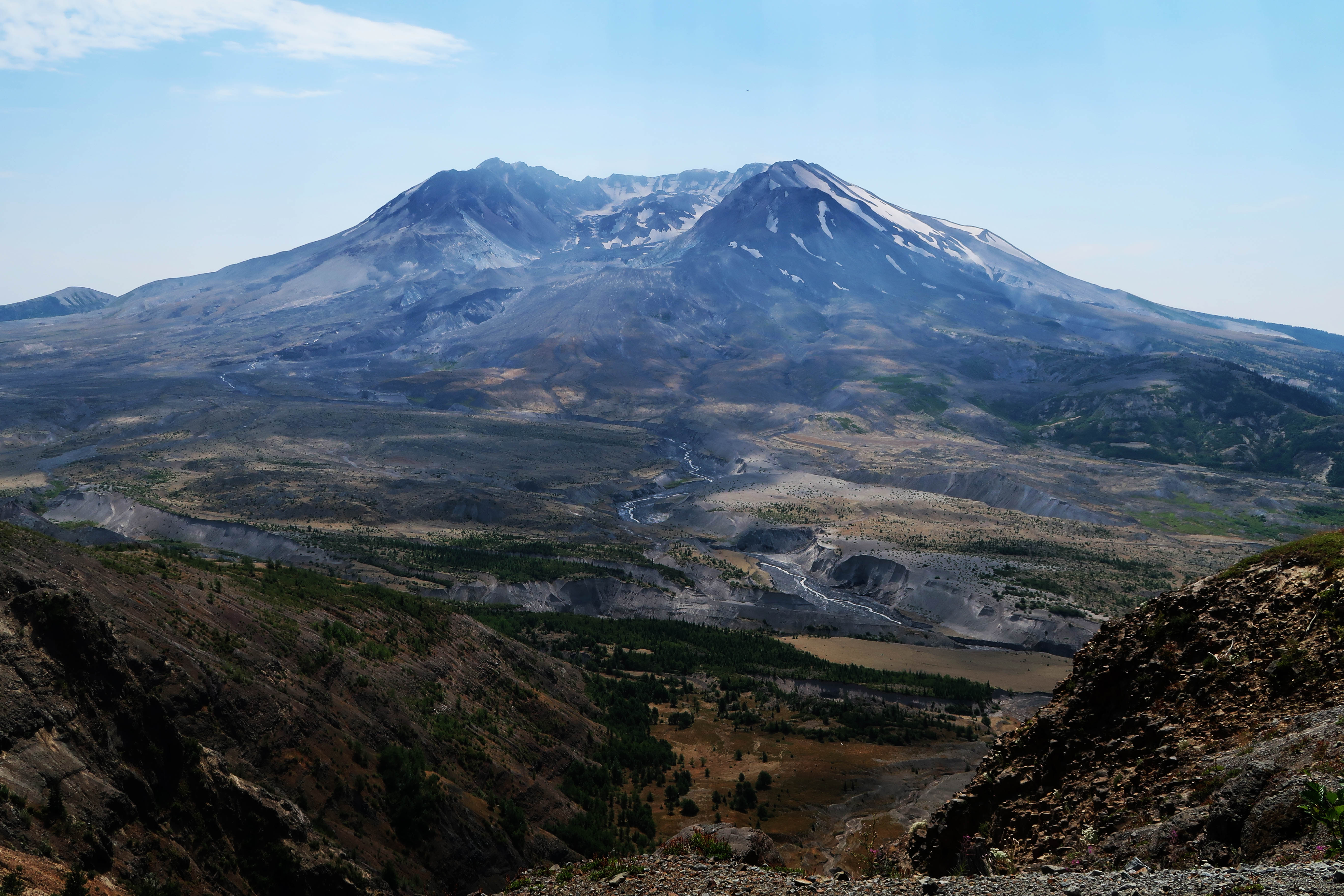
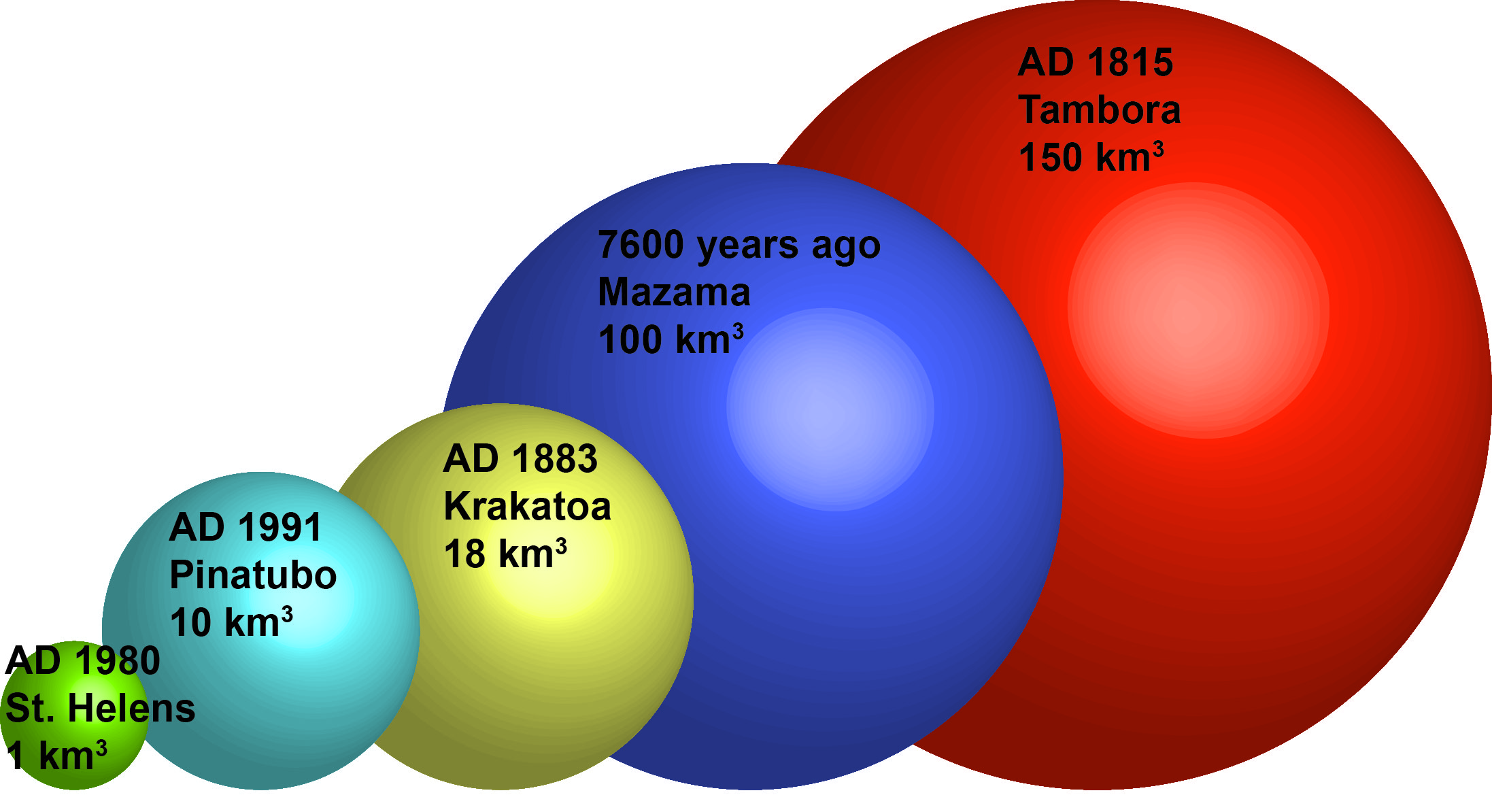
It is safe to say that when people think of Alberta they rarely think of volcanoes. Prairies, check; mountains, check; boreal forest, check; volcanoes, ummm, no? This is a fair reaction because Alberta can’t currently claim a single volcano. However, take a look at a map and you can see that we aren’t actually that far, relatively speaking, from the impressive volcanic peaks that dot the west coast – Mount St. Helens, Rainier, Baker, Meager, to name a few. Far enough to avoid the damaging effects of an eruption? Perhaps not. On May 18th 1980, Albertans learned that we are close enough to have our province impacted by major volcanic eruptions. The eruption of Mount St. Helens, which killed 57 people locally, spread ash far and wide. Enough ash accumulated in southern Alberta to cause problems, with reduced visibility, vehicles, and people with respiratory illnesses. A light dusting of ash was even reported as far north as Edmonton. No visible layer of that eruption remains on the landscape of Alberta. But what about the past?
When we look under the ground, at pits dug during construction, road cuts, river banks and other exposures of the ground we walk upon, we can see a history of large eruptions blanketing parts of our province in volcanic ash. This record of eruptions begins after the large ice-sheets that once buried Alberta started retreating 18,000 years ago, exposing a scoured and barren landscape. The slow recolonization of Alberta’s flora and fauna is punctuated in the southern part of our province by a distinct ash bed from a massive eruption of Glacier Peak around 13,500 years ago. We know it was big because unlike Mount St. Helens, this volcanic ash was thick enough to be preserved in the geologic record and unearthed by geologists and archaeologists exploring the past.
Although the 1980 eruption of Mount St. Helens hasn’t left an obvious mark on the geologic landscape of Alberta, this volcano had a very active past that did impact Alberta in what would have been a much more frightening experience for those living here at the time. Mount St. Helens was quiet for close to 6000 years until it awoke dramatically around 4000 years ago in what turned out to be the largest eruption from this volcano in the last 10,000 years. The volcanic ash from this eruption, which we geologists call “Mount St. Helens Yn”, shot straight to the northeast, and today we can find it across large parts of the Rockies, foothills and out onto the prairies in central Alberta. It is especially conspicuous from the Nordegg area to Hinton, and has even been found in Hasse Lake, on Edmonton’s doorstep.
Keeping Mount St. Helens Yn company in the foothills and mountains of the central part of the province is another ash. It looks similar to Yn, white with dark specks when we find it in the field and dominated by tiny pumice shards under the microscope. This ash is a bit younger than Yn and from Mount Meager, one of the northern-most Cascade volcanoes near Pemberton BC. We call it the Bridge River Ash, and it is around 2500 years old. Covering a large part of central BC, Bridge River made it to Alberta and can be found along river banks from Calgary’s Fish Creek Provincial Park, and along the foothills, towards Hinton.


There is one more eruption to discuss, one distinct from the others mentioned here. The volcanic ashes we have mentioned so far were from very large volcanic eruptions, but this last one was almost unimaginable in size. The eruption of Mount Mazama 7600 years ago was one of the largest eruptions in the last 10,000 years of Earth’s history. An eruption so large it obliterated the volcano that it came from – leaving behind what is now Crater Lake in Oregon. This absolutely massive eruption spread ash across much of the western USA and Canada and is even found as a microscopic layer in Greenland. Today we can find it all over southern and central Alberta, up to 15 cm thick in some locations. It would have had a devastating impact on the indigenous people living in the west – burying the landscape, muddying waters, and destroying food sources – making it very hard to travel and live. Archaeological evidence suggests that it displaced people, with a rich archaeological record below the ash, but a quiet time (that may have lasted a couple of hundreds year in some locations) above the ash. It is hard to understand what something like this would do to modern Alberta. The only eruption in historic times that was close in size to this event was the AD 1815 eruption of Tambora in Indonesia that caused the “year without summer,” devastated the local environment, and caused the deaths of hundreds of thousands of people. Luckily these events are incredibly rare and will not likely happen in our lifetimes. But isn’t it an interesting thought, that here in Alberta, the land of prairies, mountains and boreal forest, we also have a story to tell about volcanoes?

Today you can see these ashes yourself in river banks and road cuts across the province. Some of the best viewing is in the Nordegg area, where you can see Mazama, Mount St. Helens Yn and Bridge River all together. These ashes are important to geologists and archaeologists as markers for certain time periods because these distinct bands tell them how old the sediments and artifacts associated with them are. But as you examine these thin white bands of fine ash, think about how even a relatively small event like the 1980 eruption of Mount St. Helens reached our province and deposited ash, although not enough to be preserved on the landscape. Then see these visible ashes, think about how much bigger these eruptions were and what that could mean for Alberta today.
Written By: Britta Jensen (Assistant Professor, Department of Earth and Atmospheric Science, University of Alberta)
References
Jensen, B.J.L., Beaudoin, A., 2016. Geochemical characterization of tephra deposits at archaeological and palaeoenvironmental sites across south-central Alberta and southwest Saskatchewan. Archaeological Survey of Alberta Occasional Paper 36, 154-160.

Hello i live by a vent hole from a valcano water come out the hole but many many years ago lave came out of hole there is a large diposit of lave rock 150ft wide 200ft long and around 25 to 30ft thick