Cameron Creek (Oil Creek) and Cameron Lake (Oil Lake)

Most people understand the importance of the oil discovered at Leduc in 1947 and the oil and gas discovered in Turner Valley in 1914. However, Alberta’s oil and gas industry began in 1901 with an isolated oil well alongside a creek near the Canada-United States border.

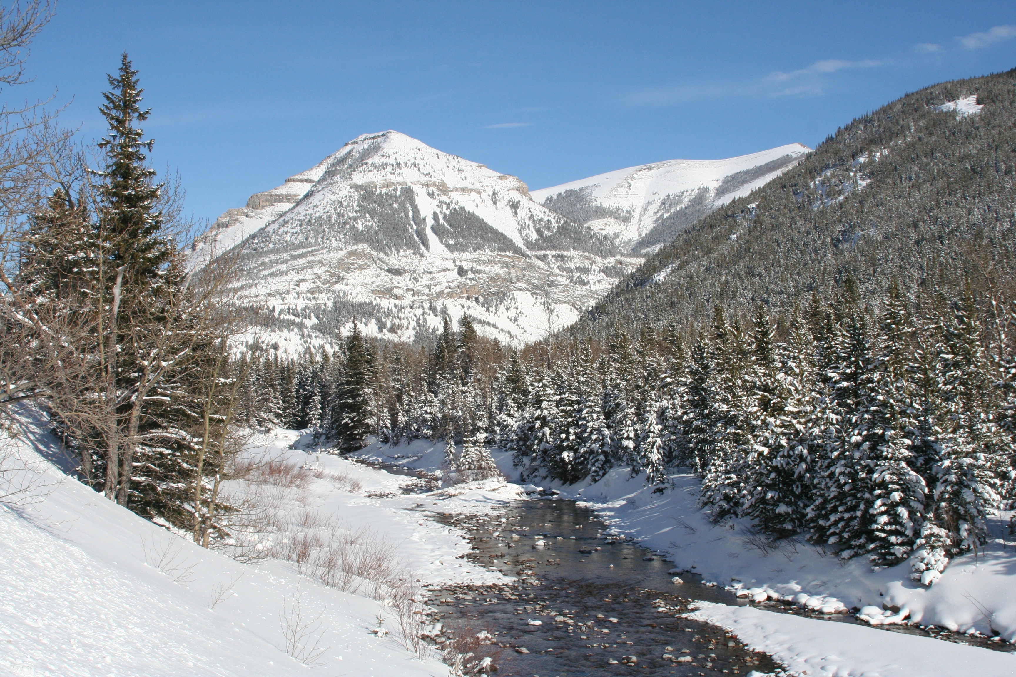
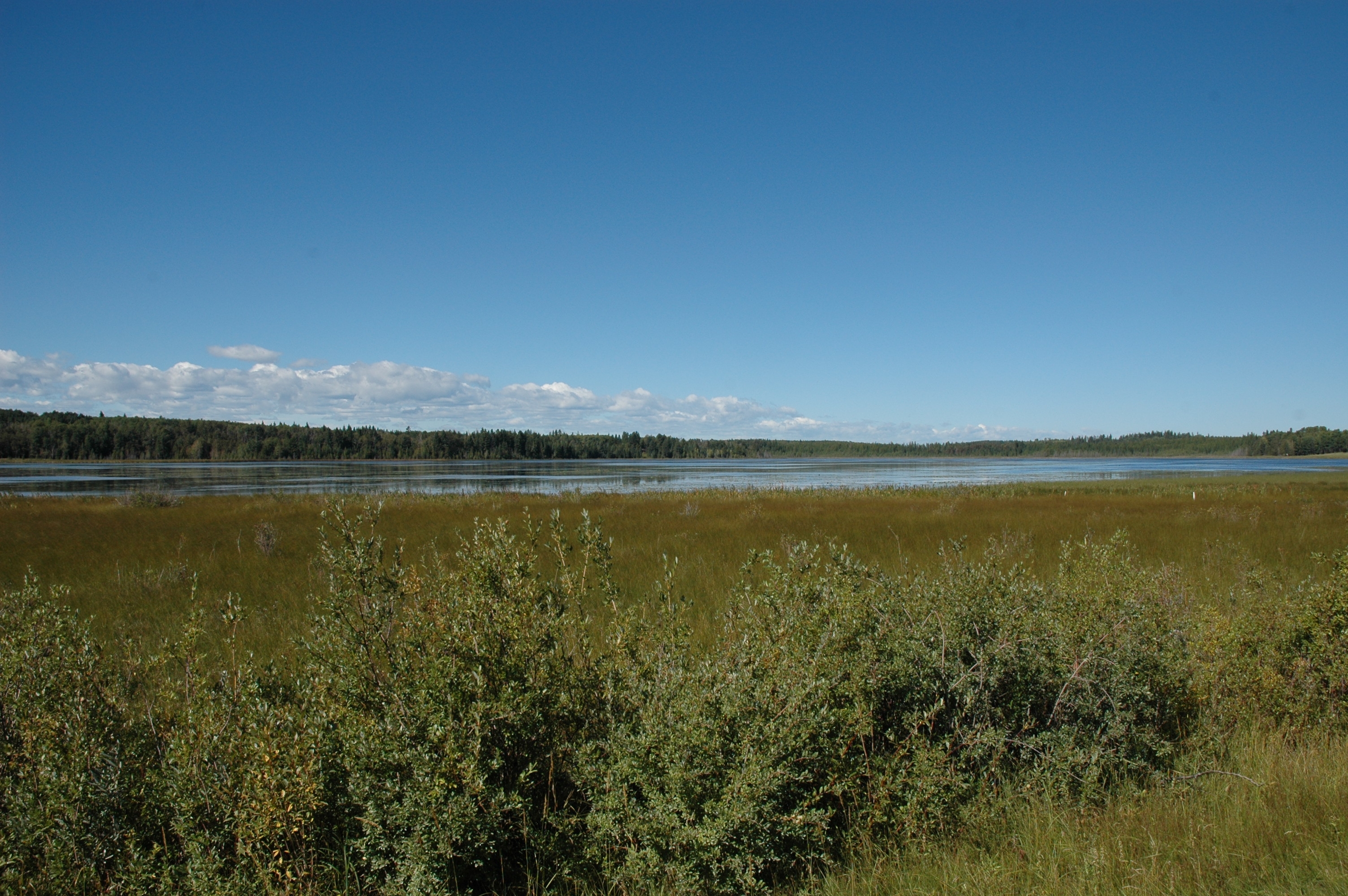
That creek was known as Oil Creek. Now known as Cameron Creek, this 15 kilometre long creek runs north-easterly for about 9 kilometres before turning and flowing south-easterly into Upper Waterton Lake. The source of the creek is Cameron Lake, a small lake on the Canada-U.S. border deep within Waterton Lakes National Park. The lake was once known as Oil Lake. (Do you see a pattern?)

Aerial Imagery of Waterton Lakes National Park, showing the locations of the Cameron Lake (formerly Oil Lake) Cameron Creek (formerly Oil Creek) and the First Oil Well in Western Canada National Historic Site of Canada.

The lake and the creek were noted, but not named, on George Dawson’s 1884 map of the Bow and Belly River region of the North-West Territories. During his surveys of the area in the 1880s (with the Geological Survey of Canada) and earlier (with the International Boundary Commission) in the 1870s, Dawson was made aware of oil and gas in the Waterton region. In 1901, the Rocky Mountain Development Company drilled Western Canada’s first oil well alongside a creek, which soon became known, for obvious reasons, as Oil Creek.

In 1915, during the survey of the Alberta-British Columbia border, the lake and creek were again noted. The 1917 report on the Alberta- B.C. boundary described them as: “Cameron Lake, a picturesque sheet of water, one mile and a half long by half a mile wide” and “Cameron Brook, a stream of considerable size, which flows to Upper Waterton Lake”.

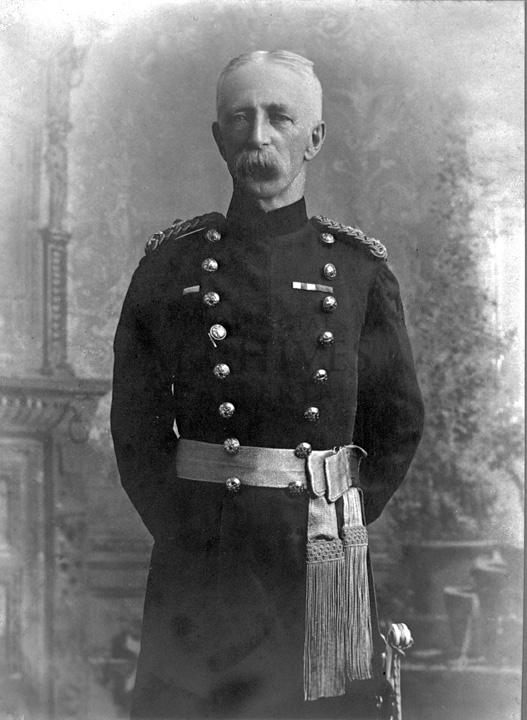
The lake and creek were named for Maj.-Gen. Donald Roderick Cameron, a Scottish-born Royal Artillery officer and son-in-law to Sir Charles Tupper. Prime Minister John A. Macdonald recommended Cameron’s appointment as the British Boundary Commissioner and head of the British-Canadian delegation to the International Boundary Commission. From 1872-76, Cameron oversaw the surveying of the Canada-U.S. border between the Lake of the Woods (in western Ontario) to the Rocky Mountains. He later represented Canada on numerous international commissions and conferences through the 1880s and he served as commandant of the Royal Military College in Kingston, Ontario from 1888 to 1896. For his services to the boundary commission he was appointed to the Order of St. Michael and St. George by Queen Victoria. General Cameron died in 1921. In 1943, Cameron Falls, just north of the Waterton Park town site, was also named in his honour.

Portrait of Capt. Donald R. Cameron, head of the British-Canadian contingent of the International Boundary Survey, in 1872.
Capt. Donald R. Cameron, head of the British-Canadian contingent of the International Boundary Survey, in 1872.

In 1915, the Geographic Board of Canada adopted Cameron Brook as the official name for the creek. Although, the name of the lake was not officially changed at the time, it nevertheless began appearing on federal government maps as Cameron Lake. The name Cameron Lake was officially adopted in 1928. The following year, the United States Board on Geographic Names adopted the same name for the portion of the lake located in Montana. In 1960, the Canadian Board on Geographical Names renamed Cameron Brook as Cameron Creek.

A photo of Cameron Creek, formerly known as Oil Creek, flows through the rugged terrain of Waterton Lakes National Park. Western Canada’s first oil well was located alongside this creek.
Cameron Creek, formerly known as Oil Creek, flows through the rugged terrain of Waterton Lakes National Park. Western Canada’s first oil well was located alongside this creek.

Although the names Oil Lake and Oil Creek are no longer official, the significance of the area in the development of Canada’s oil sector is commemorated by the Historic Sites and Monuments Board of Canada. In 1965, a monument was erected at the site the original oil well and the site was named the First Oil Well in Western Canada National Historic Site of Canada.

Written by: Ron Kelland, Historic Places Research Officer and Geographical Names Program Coordinator.

Location

Cameron Creek
National Topographic System Map Sheet: 82 H/04 – Waterton Lakes
Latitude/Longitude: 49°01’11N / 114°02’38”W to 49°02’41”N / 113°54’45”W
Alberta Township System: SW11-01-01-W5 to NW14-01-30-W4
Description: Flows into Upper Waterton Lake within the Waterton Park town site.

Cameron Lake
National Topographic System Map Sheet: 82 G/01 – Sage Creek
Alberta Township System: 2, 3, 10, 11-01-01-W5
Description: On the Canada/US border approximately 11 km south west of the Waterton Park town site and 1 km east of the Alberta/British Columbia boundary.

Additional Resources

More information about Cameron Creek, Cameron Lake, Maj-Gen. Donald R. Cameron and the First Oil Well in Western Canada can be found in:

Edwards, Victoria. “Major General Donald Roderick Cameron C.M.G.” eVeritas [electronic newsletter of the Royal Military College Club], available from http://everitas.rmcclub.ca/?p=4485. (Accessed 16 Oct 2013).

Parks Canada. “First Oil Well in Western Canada National Historic Site of Canada,” [webpage], available from http://www.pc.gc.ca/docs/v-g/pm-mp/lhn-nhs/puits-well_e.asp. (Accessed 16 Oct 2013).

Rees, Tony. Arc of the Medicine Line: mapping the World’s Longest Undefended Border across the Western Plains. Lincoln, NB: University of Nebraska Press, 2007.

Alberta and the coronation of Queen Elizabeth II

Queen Elizabeth II in coronation robes
Queen Elizabeth II in coronation robes. © Cecil Beaton, 1953.

Last Sunday (June 2nd) was the 60th anniversary of  Queen Elizabeth II’s coronation. She had been Queen for over a year at the time. (She ascended to the throne upon the death of King George VI, her father, in February 1952.) The timing allowed for a period of mourning for the late King and to organise the pomp and ceremony of a coronation.

Canada marked the occasion by naming a large mountain range in Jasper National Park for our new Queen. Many places names in Canada have been inspired by members of the Royal family. To learn more about this you could revisit our post on the Royal Jubilee, Queen Elizabeth II and Place Names.

Written by: Ron Kelland, Historic Places Research Officer and Geographical Names Program Coordinator.

Adams Lake: Officially Recognizing a Long–standing Local Name

Adams Lake (looking west), August 29, 2012, Alberta Geographical Names Program

The Alberta Historical Resources Foundation and the Minister of Culture has officially adopted the name Adams Lake for a small lake in Red Deer County (see information bulletin). The lake is approximately 100 hectares (250 acres) in size and located about two kilometres south of Raven and 35 kilometres west of Innisfail. The adoption of this name is significant as it commemorates the Adams family, who homesteaded in the region, and recognizes a name that has been used locally for about 100 years.

David Arthur and Julia Marie Adams, 1902, Photograph courtesy of the Adams family

The name commemorates the family of David and Julia Adams. David Arthur Adams was born in Stratford, Ontario. As a young man he met Julia Marie Hedlund, of Chippewa County, Minnesota at a hotel in Lakota, North Dakota. They were married in 1902 and lived for a time with David’s parents in Birtle, Manitoba. The couple soon struck out on their own and lived for a time in Vancouver and Mission, British Columbia and in Calgary, Alberta. Ultimately, in 1912, they settled on a homestead in the Raven District. The homestead, NW2-36-4-W5, was on the eastern shore of a small lake. The lake had been previously noted as “Lake No. 3” in a 1904 Dominion Land Survey Plan of Township 36-4-W5 and it appears unnamed on most federal government maps of the region following that date. It became popular with people from as far away as Spruce View for skating in the winter months and after 1912, it became known to locals as “Adams Lake,” likely due to the family’s proximity.

By the time the Adams’ had settled near Raven, they were raising six children, and four more were born during their time at the homestead. According to David and Julia’s descendents, the land the family was working was not ideal for agriculture and, perhaps for this reason, at the age of 42, David Adams enlisted for service with the 187th (Central Alberta) Regiment during the First World War. Following the war he returned to farming. However, as the older children grew up and left home for farms in the neighbouring districts, and other careers of their own in Spruce View, Bowden, Innisfail and Rocky Mountain House, the farmstead was not sustainable and at some point in the 1920s David and Julia also left the area. David passed away in Calgary in 1942. Julia lived with her children in the Dickson and Kevisville districts and the Pigeon Lake area before also passing away in Calgary in 1966.

Aerial Imagery: Adams LakeAlthough the Adams family remained in the general area for some time, their direct association with the lake was relatively short. However, field research done by the Alberta Geographical Names Program in 1981 and 2012 found that the name Adams Lake was still being used by many local residents and that the name had been in use since at least the 1920s, probably even longer. The lake has also been identified by that name in local publications, newspapers and water conservation reports for the area.

In Alberta, geographical names are adopted after being evaluated against the “Principles of Geographical Naming.” These principles can be found in the Geographical Names Manual. The principles to approve names are based on national and international standards and guidelines and hold that names that have a demonstrated local and/or historical usage should be given primacy when names are being considered for features with no official name. In 2011, Robert Nanninga, a resident of the Raven area applied to Alberta Culture to have the long-standing, but unofficial name given official recognition by Alberta Culture. A considerable amount of information was provided by the applicant and the region’s local history (Grub Axe to Grain…). However, the real breakthrough came when another area resident put researchers in touch with Ken Adams, a grandson of David and Julia. Through him connections were made with Georgina O’Coin, a granddaughter, and Edith Hudson (née Adams), the last surviving child of David and Julia. When these three family members were interviewed in Red Deer in August 2012, Mrs. Hudson was 101 years old. The information given during this interview proved invaluable in firming up the history of the lake and family by providing more details than were included in the local history. It was a true pleasure to be able to meet with the descendents of this homesteading family.

LtoR: Georgina O’Coin, Ken Adams, Edith Hudson (née Adams). Taken at Red Deer, August 29, 2012, Alberta Geographical Names Program

The Adams Lake naming proposal was supported by the Municipal Council of Red Deer County. The Board of the Alberta Historical Resources Foundation decided to officially adopt the name during their October 20, 2012 meeting in Banff. On November 19, 2012, the Minister of Culture concurred with the board’s decision and the adoption of the name became official. Notification of the adoption of the name Adams Lake was published in Alberta Gazette on January 15, 2013. Notification of the new official name has been communicated to provincial mapping authorities and to the Secretariat of the Geographical Names Board of Canada for inclusion in the Canadian Geographical Names Database, ensuring that the name will appear on new maps of the region produced by the federal and provincial governments.

Written by: Ron Kelland, Historic Places Research Officer and Geographical Names Program Coordinator

Location

National Topographic System Map Sheet: 83 B/1 – Markerville

Latitude/Longitude: 52° 04′ 05″ N & 114° 29′ 05″ W

Alberta Township System: Sec. 3 Twp. 36 Rge. 4 W5

Description: Approximately two km south of Raven and 35 km west of Innisfail (town).

Additional Resources 

Additional information about the lake and the Adams family can be found in:

Grub Axe to Grain…: A History of Craig, Dickson, Happy Hill, Heckla, Hola, Markerville, New Hill, North Raven, Raven, Red Raven, Rich Hill, Spruce View (Spruce View: Spruce View School Area Historical Society, 1973). Available from Our Future Our Past: The Alberta Heritage Digitization Project, University of Calgary, http://www.ourfutureourpast.ca/loc_hist/toc.aspx?id=7618.

Alberta Wheat Pool Grain Elevator, Big Valley

Alberta Wheat Pool Grain Elevator (DSC_5353 Historic Resources Management Branch).

Today’s blog post will no doubt please all of our railroad and grain elevator enthusiasts out there in the ether. On August 27, 2012, the Alberta Wheat Pool Grain Elevator in Big Valley was designated as a Provincial Historic Resource and added to the Alberta Register of Historic Places. This grain elevator has heritage significance due essentially to the fact that it is…, well, it’s a grain elevator. These once dominant, landmark structures in rural Alberta have become iconic symbols, speaking to the province’s agricultural, social and railroad transportation history. This particular elevator also contributes to the cultural landscape of Big Valley, aiding in the visual communication of the community’s history as one of the province’s busiest railroad divisional points.

Wood-cribbed grain elevators such as the Alberta Wheat Pool elevator in Big Valley were once a dominant presence in the lives of most rural Albertans. These imposing, structures stood out on the horizon and could be seen from miles around. They were essential facilities for the sorting, storage, and transportation of grains and, as such, they also served an important social function as meeting places for area farmers. Although there were some variations in elevator design, size and services, they remained consistently similar in basic design and form over the years. This Alberta Wheat Pool grain elevator was a relatively late addition, being built in 1960, but it shares much with its earlier predecessors, notably its vertical orientation, gable-roofed cupola, shed-roofed drive shed with earthen ramps and overall lack of fenestration.

(DSC_2647 Historic Resources Management Branch).
View of the Alberta Wheat Pool Grain Elevator, Big Valley (DSC_2647 Historic Resources Management Branch).

In 1912, Big Valley had been selected as a divisional point on the Canadian Northern Railway’s (CNoR) Battle River Subdivision. At one point it possessed a large railyard and a number of important railroad maintenance facilities and storage areas for fuel, water and freight. Largely supported by the railroad, Big Valley was a bustling centre with a large population. In the late-1920s, Big Valley’s boom period came to an end when the divisional point was moved to Mirror on the former Grand Trunk Pacific Railway line.

Although the 1960 Alberta Wheat Pool grain elevator was built long after the Big Valley’s glory days as a divisional point, its presence adds to the interpretation of the community’s railroad heritage, particularly when considered together with the presence of other designated historical resources, such as the historic CNoR railway station and the remains of the roundhouse and frequent visits by the Canadian National Railways 6060 steam locomotive.

More information on the Alberta Wheat Pool grain elevator in Big Valley can be found on the Alberta Register of Historic Places.

Written by: Ron Kelland, Historic Places Research Officer and Geographical Names Program Coordinator

Queen’s Hotel, Fort Macleod

Mid-way through last year, the Queen’s Hotel in Fort Macleod was added to the Alberta Register of Historic Places. The Queen’s Hotel was designated as a Provincial Historic Resource on May 22, 2012. The building was deemed to possess heritage significance as it is an excellent example of the type of substantial hotels built in Alberta’s urban centres during boom periods of the late 1800s and early 1900s. The hotel also contributes to the heritage character of the Fort Macleod Provincial Historic Area.

The Queen’s Hotel, Fort Macleod, 2007. DSC_8336, Historic Resources Management Branch

Fort Macleod was one of Alberta’s earliest and most important urban centres during the settlement period. As a thriving commercial hub and service centre for the surrounding ranching and farming communities, a number of buildings were constructed in the town’s downtown area. Locally-quarried sandstone became the building material of choice, largely due to its fire-proofing properties and the sense of stability and permanence it lent to the business and town.

The Queen’s Hotel was one of the first buildings in Fort Macleod to be built of sandstone. It was built in 1903 to replace an earlier, smaller, wood-frame hotel of the same name. The hotel is a three-storey, flat-roofed building with a U-shaped footprint. It is a prominent building in downtown Fort Macleod, being located on the northeast corner of 24th Street and Second Avenue in the town’s main commercial district. It is constructed of rough-faced sandstone blocks and is crowned by a substantial, pressed metal cornice. On completion, the Queen’s Hotel was touted as Fort Macleod’s finest lodgings and it was the most expensive accommodations in town. The Queen’s Hotel quickly became the hotel of choice for travelling business people, politicians and government officials and other well-heeled visitors to the area.

The Fort Macleod Provincial Historic Area (Queen’s Hotel at left), 2010. DSC_1150, Historic Resources Management Branch

Like most small-town hotels, the Queen’s fortunes declined following the Second World War. As tastes in travel accommodations changed, the hotel became known more as a downtown tavern with low-cost rental apartments. The hotel has also undergone a number of alterations over the years, a substantial one-storey addition has been added to the rear of the building and, as is often the case in buildings of this nature, the layout of the main floor has been dramatically altered. However, the hotel’s sandstone construction and overall style and design continue to communicate its historical significance as an early, business-class hotel and it continues to serve as an impressive visual anchor to Fort Macleod’s historic commercial district.

More information on the Queen’s Hotel can be found on the Alberta Register of Historic Places.

Written by: Ron Kelland, Historic Places Research Officer and Geographical Names Program Coordinator

St. Luke’s Anglican Church, Red Deer


St. Luke’s Anglican Church, ca. 1906 (prior to the construction of the tower) PA-377-8, Glenbow Archives

St. Luke’s Anglican Church in Red Deer is one of the more recent additions to the Alberta Register of Historic Places. St. Luke’s is significant due to its Gothic Revival style of architecture and the use of sandstone in its construction. The Government of Alberta previously designated the church as a Registered Historic Resource in 1978. The designation was revaluated and upgraded to a Provincial Historic Resource on August 27, 2012. St. Luke’s was also designated as a Municipal Historic Resource by the City of Red Deer in 2009.

(DSC-3460.jpg) View of the sanctuary and altar. Historic Resources Management Branch, 2008

The parish of St. Luke’s was formed in 1893. In 1899, Reverend Joshua Hinchliffe became the parish priest and proposed the construction of a new church at a central location in Red Deer. Construction, which was done in stages, began in the summer of 1899. The chancel and sanctuary were completed in 1900, followed by the nave in 1904 and vestry and tower in 1906. The church was built by an Edmonton-based firm, but it is very likely that Rev. Hinchliffe played a large role in the design. Hinchliffe had trained for the priesthood in England where he would undoubtedly have been influenced by architectural theories of the Ecclesiological Society. This group of Anglican theorists developed architectural guidelines for Anglican cathedrals and churches. Amongst other things, they strongly mandated the use of the Gothic Revival style, a clear definition between areas of the church and the use of natural materials, particularly stone walls with wood interiors and roofs.

(Photo DSC_4871.jpg) Interior view of the west-facing stained glass window. Historic Resources Management Branch, 2009

St. Luke’s Anglican Church incorporates many of the design and construction elements characteristic of the principles mandated by the Ecclesiological Society. It is constructed of locally-acquired sandstone and features Gothic arches throughout. There is a clear demarcation between the sanctuary and nave and it is oriented on an east-west axis, with the altar to the east and the main entrance and tower to the west. Somewhat unusual in a province where most early churches were built of wood, St. Luke’s is a wonderful, if smaller than typical, example of an Ecclesiological Society-influenced church in Western Canada.

(DSC-4868a.jpg) View showing the west and north elevations. Historic Resources Management Branch, 2009

St.  Luke’s Anglican Church remains in use as an active church and is the oldest actively-used church in Red Deer. More information on St. Luke’s can be found on the Alberta Register of Historic Places.

Written by: Ron Kelland, Historic Places Research Officer and Geographical Names Program Coordinator

Andrew

Apparently we can use some kind of built in WordPress web analytics tool to find out which search terms people enter into their web browsers to arrive at RETROactive. Curiously, over the past few days, there have been a number of searches for the origin of the name Andrew, which is a village in east-central Alberta. There is nothing on RETROactive that will provide that information, so I figured I would make the origin of the name of the Village of Andrew the subject of this post. So, anonymous searching person, I don’t know if you are still out there, but This One’s For You!!!

Andrew is a village located in east-central Alberta, approximately 70 km northeast of Edmonton and 45 km NNW of Vegreville. The community is named for prominent, early resident Andrew Whitford, who was a member of the large Métis, Whitford family that resided in the vicinity of Victoria Settlement. The nearby Whitford Lake, Whitford Creek and the hamlet of Whitford are all named for the family.

Andrew MapAndrew Whitford was born about 1830. It appears that he worked as a freighter and travelled extensively throughout the North West Territories. In 1885, he served as a scout during the North-West Rebellion, for which he, along with other scouts and militia members, received two adjacent quarter sections of land. Whitford selected the SE and SW quarters of Section 32, Township 56, Range 16, West of the 4th Meridian. He was widely acknowledged as a leader in the community; issues of the Edmonton Bulletin note many instances of his support for local charitable causes and his frequent support for orphaned children and destitute families in the Star/Whitford/Andrew region through the late 1890s. He also served as a founding trustee and later treasurer of the local school district, which was established in 1895 and called, fittingly enough, the Whitford School District No. 393. In the spring of 1901, a small pox epidemic broke out in east-central Alberta. Andrew Whitford contracted the disease and passed away on April 26. A short obituary appeared in the May 3, 1901 issue of the Edmonton Bulletin:

Died, at Whitford on April 26th, 1901, Andrew Whitford, aged about 70 years of small pox and complications. The demise of Mr. Whitford removes from our midst a man of universal respect and an old land mark of the west who could tell many reminiscences of early life between old Fort Gary and Vancouver. He was a trusted and worthy scout of ’85, and saw much of the stirring rebellion. At his death he was treasurer of Whitford P.S.D., April 26, 1901.

Main Street of Andrew, Alberta, ca. 1930. Photograph by Nicholas W. Gavinshuk, Provincial Archives of Alberta, G208.
Main Street of Andrew, Alberta, ca. 1930. Photograph by Nicholas W. Gavinchuk, Provincial Archives of Alberta, G208.

John Borwick, a long-time guide and early settler in the same region, operated a stopping house at NW28-56-16-W4, near the junction of the Winnipeg Trail and the Calgary-Pakan Trail. Following Whitford’s death, Borwick named the stopping house the Andrew Hotel, in honour of his friend and long-time compatriot. Alongside the Andrew Hotel was a store owned by Ed Carey. On March 1, 1902, a post office was established and given the name Andrew. Eliza Borwick, John’s wife, was the first postmaster. A small, but thriving rural community began developing around these three facilities.

In 1928, after much lobbying by area residents, the Canadian Pacific Railway built a line through the region and surveyed a town site at SE32-56-16-W4 on the north side of the tracks. The rural community of Andrew was located mostly on the neighbouring quarter section to the southeast. The Andrew Hotel, the post office, the store and most of the rest of the community moved to the new surveyed town site. Fittingly, the new town site of Andrew was located on one of Andrew Whitford’s original quarter sections. Two years later, on June 24, 1930, Andrew was erected as a village. According to 2011 Census of Canada, the Village of Andrew has a population of 379, down from 465 in 2006.

Written by: Ron Kelland, Historic Places Research Officer and Geographical Place Names Coordinator

Location

National Topographic System Map Sheet: 83 H/16 – Willingdon

Latitude/Longitude:

53° 52’ 42” N & 112° 20’ 07” W

Alberta Township System:

Sec 32 Twp 56 Rge 16 W4

Description:

Approximately 70 km northeast of Edmonton and 45 km NNW of Vegreville.

Additional Resources

More information about the Village of Andrew can be found in:

Andrew Historical Society, Dreams and Destinies: Andrew and District, (Andrew: Andrew Historical Society, 1980).

Cathy Chorniawy, Commerce in the Country: A Land Use and Structural History of the Luzan Grocery Store, (Edmonton: Alberta Culture, Government of Alberta, 1989).

Canadian Pacific Railway Section House, Coronation

(Photo 20060621_8707.JPG)
View from the southeast, showing the Section House and the former rail yard.
Historic Resources Management Branch, 2006

The Canadian Pacific Railway Section House in Coronation is the latest addition to the Alberta Register of Historic Places. The building was previously designated as a Registered Historic Resource in 2002. The resource was  revaluated and its designation was upgraded to Provincial Historic Resource on August 27, 2012. The building, also known as the Section Foreman’s or Roadmaster’s House is significant as it is representational of CPR divisional point architecture and demonstrates the type of housing provided by the railway to essential railway employees.

(Photo 20060621_8714.JPG)
View from the southwest (trackside).
Historic Resources Management Branch, 2006

Coronation, which is located about 120 km east of Stettler, became the divisional point for the CPR’s Lorraine subdivision, which eventually connected Youngstown in the south and the coal mines at Halkirk in the north to the main line. The Section Foreman was responsible for track maintenance on the subdivision. The CPR believed that men with established families were better qualified for positions of responsibility and housing was often provided for them as a way of attracting and retaining such people. At one point Coronation had three section houses in a line adjacent to the town’s rail yard. These houses were built according to a CPR standard plan, and were utilitarian in nature and featured simple ornamentation and were constructed of low-maintenance materials.

(Photo 20060621_8646.JPG)
Section House Interior, Dining Room.
Historic Resources Management Branch, 2006

With changing technology, the use of divisional points evolved and many section houses were either abandoned, lifted and moved or simply torn down. The Coronation section house, which is now used as a local museum, remains on its original site and effectively communicates its provenance as an essential, and often over-looked, element of railway infrastructure.

More information on the Canadian Pacific Railway Section House in Coronation can be found on the Alberta Register of Historic Places.

Written by: Ron Kelland, Historic Places Research Officer and Geographical Names Program Coordinator

Lee Creek (Or is it “Lee’s Creek”?) – Part 2 of 2

In Part 1, we read about “Lee’s Creek,” as mentioned in Corb Lund’s song “The Truth Comes Out” and how Lee Creek in the Cardston area is named for early pioneer William Samuel Lee.  So, what’s up with the different spelling? Is it Lee Creek or Lee’s Creek? It may actually be both. Confused? Read on for more. 

Even though Lee only lived on the creek named for him for about three years (1867-1870), the name stuck. A map produced by the Geological Survey of Canada in 1884 identifies the creek as “Lee’s Creek.” In 1894, the name “Lee Creek” (without the possessive apostrophe) was recorded by the Dominion Land Survey in the field notes of surveyor Fred W. Wilkins and in the diary of Arthur O. Wheeler (for more about Wheeler see the St. Nicholas Peak post of December 22, 2011). In 1901, the Geographic Board of Canada approved the non-possessive form of the name – Lee Creek – for use on official maps. The portion of the creek south of the 49th parallel remained officially unnamed until 1929, when the United States Board on Geographical Names (USBGN) sanctioned the name Lee Creek for their portion of the water feature.

So why the different spellings of Lee/Lee’s Creek? The use of the possessive form of words in place names is generally discouraged. Some of the rationales for not using the possessive form of names are that geographical features do not belong to a single person or group, but to all people; that place names are not words with a specific dictionary meaning, but are labels to which standard grammatical rules do not necessarily apply; and that the presence of apostrophes cause confusion, particularly when attempting to retrieve names in modern databases, internet search engines and directional software used by emergency services (police, ambulance, fire). There is also a belief (likely apocryphal) that apostrophes were not used on early maps because they were often confused with the standard cartographic notation indicating the presence of stones and rocks.

Lee Creek with a Kainai (Blood) encampment in the distance,
taken near Cardston, 1898.

The USBGN and the Committee for Geographical Names in Australia both have policies prohibiting the use of the possessive apostrophe in the official names of geographical features. Many naming regulatory bodies in the United Kingdom have been eliminating apostrophes from their official names. Canada and Alberta also discourage the use of the possessive apostrophe, however Principle 5(A) of Alberta’s “Principles of Geographical Naming” does allow for the use of possessive forms if it can be demonstrated that form of the name is in long-standing local use.

However, despite all of the official naming standards and policies, local names and forms die hard. In the case of Lee Creek, even more than 110 years after that form of the name was officially adopted the locals still refer to it as “Lee’s Creek. When asked if the Lee Creek on the map was the same as the Lee’s Creek in his song, Corb Lund replied

Yup. Same one. It flows right through our ranch near Beazer. I grew up swimming and fly fishing it. My Grandpa, whose father homesteaded the place, called it “Lee’s Creek.” “Lee’s Crick to be really precise, but I’ve seen it called “Lee Creek.” In my experience, the locals I knew called it “Lee’s” and the book name was always “Lee,” but your mileage may vary…

At the end of the day, whatever the form the name takes, Lee (or Lee’s) Creek, the creek and its name continues to commemorate one of Alberta’s earliest pioneers.

To read Part 1, click here.

Written by: Ron Kelland, Historic Places Research Officer and Geographical Names Program Coordinator 

Location: 

National Topographic System Map Sheet: 82 N/09 – Hector Lake

Latitude/Longitude:

48° 59’ 53” N & 113° 36’ 02” W (at US/Canada border) to

49° 13′ 25″ N & 113° 15′ 59″ W (at confluence with St. Mary River)

Alberta Township System:

SW ¼, Sec 6 Twp 1 Rge 27 W4 (at US/Canada border) to

SW ¼, Sec 23 Twp 3 Rge 25 W4 (at confluence with St. Mary River)

Description:

Flows generally north-easterly from the border for approximately 65 km (35 km straight line) until it joins the St. Mary River just north of the Town of Cardston 

Additional Resources: 

More information about and images of Lee Creek and William Samuel Lee can be found in:

C. Drain, “Lee, William – The Pass was his Bull Run,” Crowsnest and its People, 2nd printing, (Coleman: Crowsnest Pass Historical Society, 1980), 662-663

Lee Creek (Or is it “Lee’s Creek”?) – Part 1 of 2

The inspiration for some of these blog posts comes from the darndest places and some have extremely long gestation periods. Such is the case with this one.

William Samuel Lee, ca. 1900

Place names have a long history of being used in popular music. While American references abound, finding songs that mention Alberta, or even Canadian places or names are much harder to find. It seems that people would rather leave their heart in San Francisco than in Sangudo or spread the news about New York rather than New Sarepta. But if you look hard enough, there are examples of Alberta place names used in songs.

It was early January 2012. I was desperately trying to get the once enjoyable, but now overplayed and cloyingly sentimental tones of Bing Crosby and Nat King Cole from running through my head like the soundtrack to some never-ending, slightly demented holiday television special. So, I popped one of my favourite CDs into the player and the wonderful sounds of Corb Lund and the Hurtin’ Albertans started emanating from my speakers. The disc eventually came around to Track 8, “The Truth Comes Out.” Now, the house is pretty quiet, and I am listening to the lyrics much more closely than I otherwise might, and I hear:

You gotta’ look out for bear when you’re fishing on Lee’s Creek

They come ‘round the bend and they’ll make your knees weak

There’s grizzlies where there was no grizzly bears before.

Now, I know that Corb Lund is from southern Alberta and even though I am the names guy, I am not all that familiar with the southern reaches of the province. After mulling over the song for awhile, I start to wonder if there really is a “Lee’s Creek.” So, I fire up the old Alberta Geographical Names Database and sure enough there is a “Lee’s Creek,” or more properly there is a Lee Creek (more on that in a moment) in southern Alberta. It is a substantial creek with an interesting history.

Lee Creek is located in south-western Alberta. It rises within Montana’s Glacier National Park and flows generally north-easterly, crossing into Canada about 16 kilometres west of the Carway, AB / Peigan, MT border crossing. It continues to meander generally north-easterly for about 60 km (35 km as the crow flies), passing through the Town of Cardston before joining the St. Mary River in Section 23, Township 3, Range 25, West of the 4th Meridian (approximately 60 km south-west of Lethbridge).

The creek is named for William Samuel Lee. According to a local history of the Crowsnest Pass region, Lee was born in England at about 1830. As a young man, he migrated to the United States and worked in New York and Ohio before making his way to California hoping to make his fortune in the gold rush. Like most prospectors, Lee’s hopes of quick wealth in the gold fields were disappointed and he headed north to Fort Benton, Montana District to try his hand at fur trading. In 1867, Lee crossed the border into Rupert’s Land where he came upon a well-used ford across a substantial creek. He established a small trading post beside the ford (just west of present-day Beazer). The creek soon became known as “Lee’s Creek.”

Lee did not stay long on the creek named for him; he moved to the Pincher Creek area in 1870 and began ranching. He squatted on land along the shores of a lake (Lee Lake, go figure) about three km south east of present day Burmis. A few years later, Lee was evicted by the Hudson’s Bay Company and he moved his ranch, buildings and all, to a site north of Burmis. Lee is an important figure in the history of the Crowsnest Pass. He is considered to be the first non-native resident of the Pass; he discovered sulphur springs near present-day Frank; opened a boarding house; and built the region’s first school. William Lee spent the rest of his life in the Crowsnest region; he died of pneumonia in 1896.

Curious to learn more? Check out Part 2.

Written by: Ron Kelland, Historic Places Research Officer and Geographical Names Program Coordinator

Location:

National Topographic System Map Sheet: 82 N/09 – Hector Lake

Latitude/Longitude:

48° 59’ 53” N & 113° 36’ 02” W (at US/Canada border) to

49° 13′ 25″ N & 113° 15′ 59″ W (at confluence with St. Mary River)

Alberta Township System:

SW ¼, Sec 6 Twp 1 Rge 27 W4 (at US/Canada border) to

SW ¼, Sec 23 Twp 3 Rge 25 W4 (at confluence with St. Mary River)

Description:

Flows generally north-easterly from the border for approximately 65 km (35 km straight line) until it joins the St. Mary River just north of the Town of Cardston 

Additional Resources: 

More information about and images of Lee Creek and William Samuel Lee can be found in:

C. Drain, “Lee, William – The Pass was his Bull Run,” Crowsnest and its People, 2nd printing, (Coleman: Crowsnest Pass Historical Society, 1980), 662-663