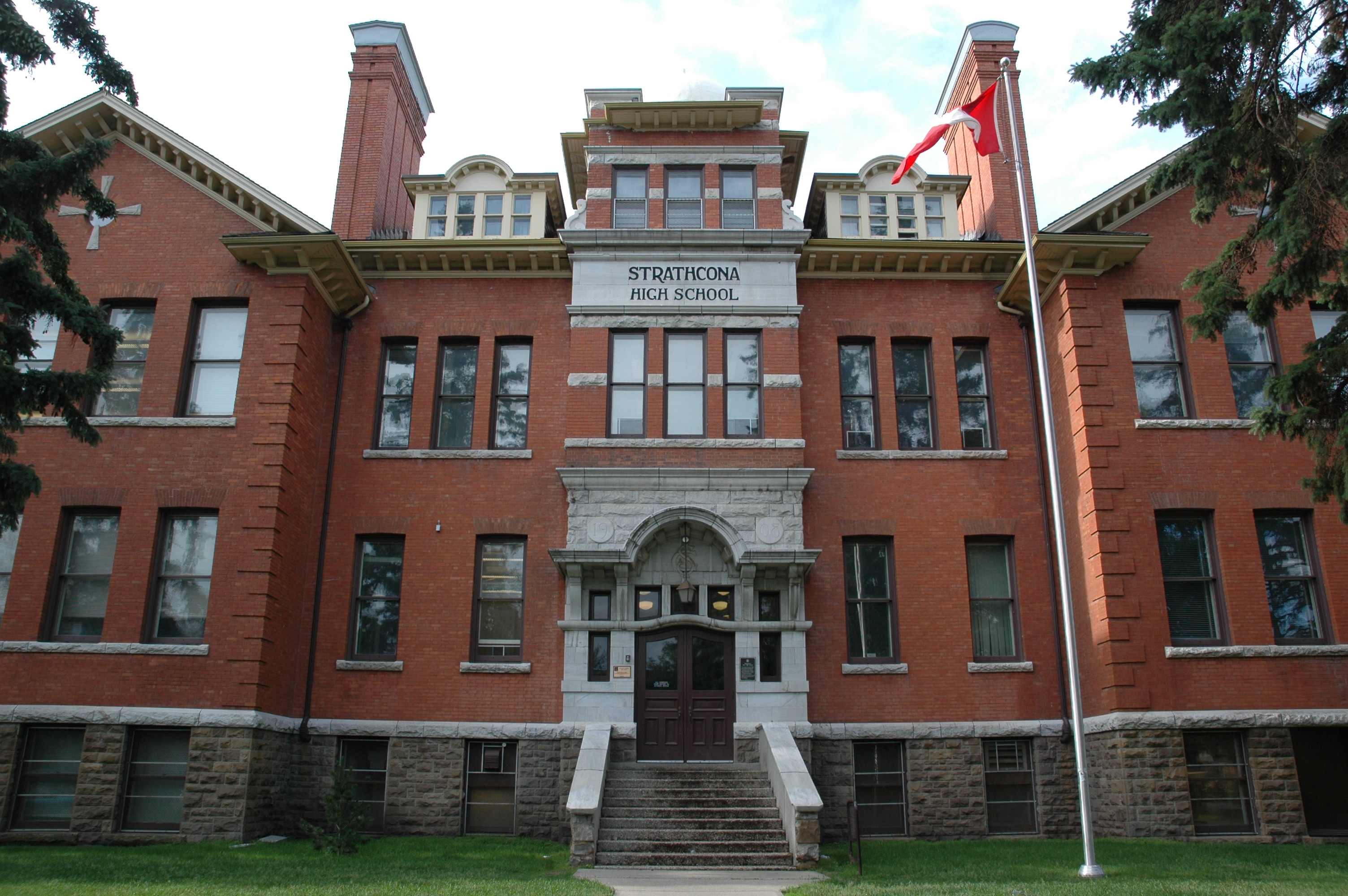
In the spirit of back to school season, here is a previous post highlighting the history of the Strathcona Collegiate Institute/Old Scona Academic High School. It was originally published on RETROactive on October 11, 2011. Enjoy!
Strathcona Collegiate Institute/Old Scona Academic High School, Edmonton
When the Calgary & Edmonton Railway arrived at the south bank of the North Saskatchewan River in 1891, the C & E immediately subdivided a townsite which it named South Edmonton. Being at the end of steel, the community steadily grew throughout the decade until, in 1899, it was incorporated as the Town of Strathcona with a population exceeding 1,000. As with Edmonton to the north, Strathcona grew rapidly in the wake of the Klondike gold rush, and, in 1907, it was incorporated as a city with an estimated population of 3,500. Edmonton, however, was destined to grow at an even greater Read more →
This post was originally published on RETROactive on August 2, 2011. The last paragraph is an addition from another blog post featuring the Wainwright Hotel, New Uses for Old Places – The Wainwright Hotel, published on March 20, 2014.
When the Grand Trunk Pacific Railway completed its line between Saskatoon and Edmonton in 1908, vast tracts of land in east central Alberta south of the Canadian Northern line were opened up for homesteading. At key points along the line, the GTP erected stations and subdivided townsites. One of these was near a small community called Denwood, where a post office and store had been opened in 1907. The new townsite, to where Denwood residents and businesses now moved, was called Wainwright, after the second vice-president of the GTP. One of the structures moved from Denwood to Wainwright was the Denwood Hotel, which soon became the Wainwright Hotel. It was owned by M.L. Forster, a strong community minded individual who served on the first village council and was mayor of the Town of Wainwright from 1927 to 1935. Read more →
Note : This post was originally published on RETROactive July 12, 2011.
Log house at the Oxley Ranch Site.
When the Montana cattle industry began to thrive in the aftermath of the American civil war, and the extension of railways to the western states, many cattle barons began to extend their activity north of the 49th Parallel. Sensitive to the encroachment of American influence in western Canada, the Dominion government took several measures to ensure the “Canadianization” of this region. A Department of the Interior was formed to oversee developments on the central prairies, a North-west Mounted Police force was formed to establish law and order, and a Dominion Lands Act was passed to see to the orderly disposition of Crown lands to British subjects, or those who would agree to become British subjects. Plans were also put in place to extend a transcontinental railway through the region. Read more →
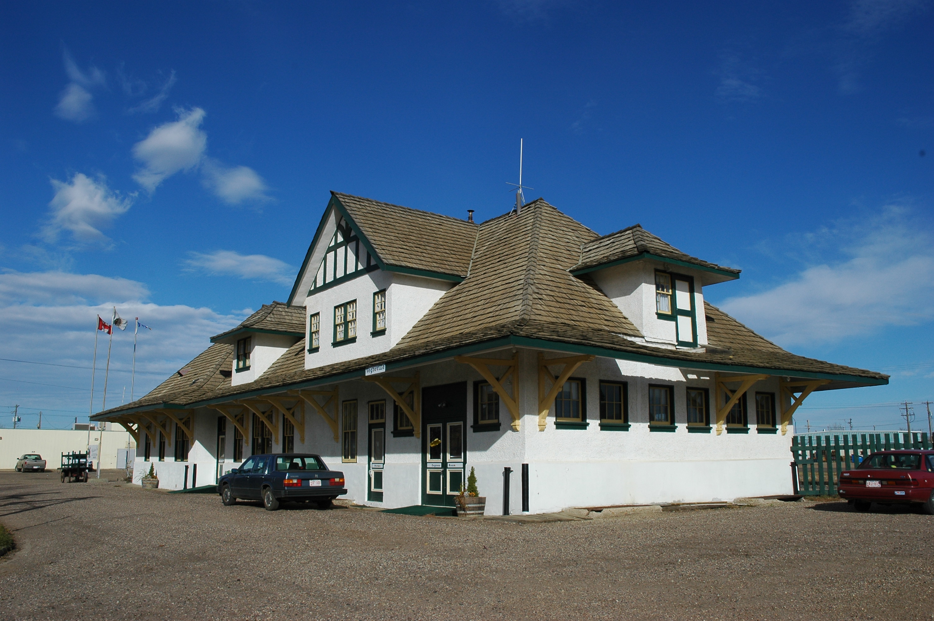
Canadian National Railway Station, Vegreville (DSC_3053 Historic Resources Management Branch).
When the Canadian Northern Railway strung its line through east central Alberta during 1904-05, a number of sidings were put up. At a few locations, stations were erected and townsites subdivided. One of the townsites was near the tiny community of Vegreville, named after the Oblate priest, Father Valentin Vegreville, in 1895 when a post office was opened. The name was probably suggested by Father Morin, who was trying to establish a Roman Catholic Francophone colony in the area. A few French settlers did come in, and, by the turn of the 20th century, a few English settlers were around as well. A number of Ukrainians were also beginning to arrive, some spilling over from Ukrainian settlements further to the east. In time, Vegreville became known as, primarily, a Ukrainian district, exhibiting many trappings of Ukrainian culture.
With the coming of the railway, many more settlers arrived, and the earlier community was soon replaced by the railway center. With the railway, farmers in the district could at last ship their produce directly to markets in the East. As the hinterland was so large, a building boom occurred in Vegreville. In August 1906, the community was incorporated, first as a village and then as a town, with over 400 people.
The district experienced much prosperity during World War I, but, like the rest of rural Alberta, it suffered from reduced grain prices following the War. The Canadian Northern was also suffering, and, in 1919, it was taken over by the Dominion government and made part of the Canadian National system of railways.
The late 1920’s was a period of high grain prices and high crop yields in Alberta. The farming population around Vegreville prospered accordingly, and also grew. By this time, CN was well aware that the old train station, built in 1906, was hardly adequate for the needs of the district. It had been built to a third class 100-3 design, as had most stations between Lloydminster and Edmonton. According to railway historian Les Kozma, most of these stations were then recognized to be inadequate. On 10 April 1929, the local Board of Trade wrote to CN Superintendent Devenish to complain that:
… the present CNR station is an eyesore and a blemish on the fair face of the town, and the facilities provided the travelling public at this station were ridiculously inadequate for the size of the town the station intended to serve.
By this time, the Canadian Pacific Railway had begun building a branch line south from Willingdon. Possibly in recognition of the coming competition, CN decided to build a new station in Vegreville. This was a two-story wood frame structure, measuring 107’ x 37’, with a stucco exterior. It was divided into four separate functional areas on the ground floor (waiting room, ticket and express office, express room, and two washrooms). The second floor was made into living quarters for the station manager and his family. A storage room and a boiler room occupied the basement. The waiting room itself was subdivided into compartments, one serving as a ladies waiting room, and another as a smoking room. The Vegreville Observer was evidently satisfied, for it observed that:
… The CN, as our pioneer railway, has always been generous to Vegreville, not unduly so, but sufficiently for our present needs.
The station’s historical significance lies in its service as a station for the entire Vegreville district from 1930 to 1975. As such, it was the nerve centre for the export of agricultural produce, and the import of finished products. It also provided a passenger service for people travelling east or west, and contained the district telegraph office.
This 1930 CN Station in Vegreville served the community as a station until 1975, at which time it was sold to the town and converted into other uses, including a seniors drop-in centre. Currently, the station houses a restaurant and provides meeting space upon request.
Visit the Alberta Register of Historic Places to learn more about the heritage value of theCanadian National Railway Station in Vegreville. In order for a site to be designated a Provincial Historic Resource, it must possess province-wide significance for either its history or architecture. To properly assess the historic importance of a resource, a historian crafts a context document that situates a resource within its time and place and compares it to similar resources in other parts of the province. This allows staff to determine the importance of a resource to a particular theme, time, and place. Above, is some of the historical information used in the evaluation of the Canadian National Railway Station.
In the summer of 1909, Dominion Land Surveyor Walter MacFarlane subdivided 17 townships on the Grande Prairie in northwestern Alberta into quarter-sections for land settlement. In the spring of 1910, the townships were thrown open of homesteading, and, during the next four years, there were 2,675 applications made for land on the Prairie, with 1,854 of them (69%) being proven up. One of the districts to receive considerable attention was that of Glen Leslie, just south of Kleskun Hill, where 144 settlers took out land. In all, these settlers made 164 applications for land, with 86 of these being proven up.
One of the homesteaders in this district was Thomas Leslie from Roslin, Ontario, who filed for and proved up NE26 TP72 R4 W6. His sons, Bruce and Norman, filed for land close by. With so much settlement in the area, Thomas applied to be the district postmaster in August, 1914. His application was granted, which was natural as his homestead was already serving as the district store. The name proposed for the post office was Glen Leslie, which reflected Leslie’s Scottish heritage. Leslie’s home also facilitated church services conducted by the Presbyterian minister Alexander Forbes from Grande Prairie.
In November 1913, Leslie and Forbes jointly applied for ten acres of SW6 TP72 R3 W6 in order to build a church and plot ground for a cemetery. The land contained a substantial bog and was not suitable for cultivation. The land granted, and, during the winter of 1914-15, logs were cut by local volunteers for a church building. Construction began on the structure that would become known as the Glen Leslie Church the following spring, with Alf Olson as the coordinator. The building committee consisted of Dan Minchin, Alex Milne, Lewis Fowler, and Bruce and Norman Leslie. The total cost, born by local fundraisers, turned out to be $468. The first service was conducted by Reverend Forbes in October, 1915. In the meantime, a cemetery was plotted just to the north
The population of the Glen Leslie district was interdenominationally Protestant, and so attendees at the Glen Leslie Church were not exclusively Presbyterian. The church building was maintained by local volunteers and was made part of the new United Church of Canada in 1925. From 1918 to 1928, it also served as the Glen Leslie School. Many other social events were held there.
In 1928, the cemetery was taken over by the Municipal District of Grande Prairie. When church services were curtailed in 1964, the County of Grande Prairie took over the church building as well. Having been well maintained, the structure was still useful for social events. It was provided with a foundation in 1970 and re-shingled in 1976. Special events continued to be held there, and, on 6 October 2011, the church was designated a Provincial Historic Resource. Its significance lies in its provision of structural evidence of the small community of Glen Leslie, one of the many districts on the Grande Prairie, from 1915 until today. The structure is important also in providing structural evidence of an early Presbyterian church in northwestern Alberta.
Visit the Alberta Register of Historic Places to learn more about the heritage value of theGlen Leslie Church. In order for a site to be designated a Provincial Historic Resource, it must possess province-wide significance for either its history or architecture. To properly assess the historic importance of a resource, a historian crafts a context document that situates a resource within its time and place and compares it to similar resources in other parts of the province. This allows staff to determine the importance of a resource to a particular theme, time, and place. Above, is some of the historical information used in the evaluation of the Glen Leslie Church.
In 1905, the Canadian Northern Railway completed a line between Lloydminster and Edmonton. As it did so, vast areas of open parkland between the two centers became immediately viable for homesteading. As the incipient farms spread out from the rail line, tiny farming communities sprang up to serve them. One of these was called Dewberry, 50 km northwest of Lloydminster, where a store and post office was erected in 1907. Among the settlers in the district was Lee Green from Illinois, who filed for a homestead on NE26 TP54 R4 W4, 10km north of Dewberry, in 1909. He also took two quarters with South African scrip four miles to the north of this, and proceeded to prove them up before returning to Illinois to marry Aleta Fleming in 1912 and bring his bride back to his farm north of Dewberry where they intended to develop it and raise a family.
Before long, Lee and Aleta began to expand their farm. During the next several years, they also raised four children. Lee was a progressive mixed farmer, apparently bringing the first gasoline powered breaking outfit to the area. He also brought in a highly valued stock of purebread Belgian horses, and built up a large herd of Aberdeen Angus cattle. As his farm expanded, he required more land, so he purchased all of section 23 TP54 R4, just to the south, from the CPR. It was on the southwest quarter of this section that he centered his operation during the 1920’s, having several buildings erected over the course of the next two decades, including a house, a large barn, a separate pig barn, a blacksmith shop, a machine shop, and a separate residence for hired help. He even built a teacherage for teachers of the nearby Riverton School in 1948. By this time, the farm became a model for the district, which had become known as Greenlawn, and the farm Greenridge. The viability of the expanded operation had been given validity by the extension of a CPR line through Dewberry in 1927.
Being among the more prominent residents in the district, Lee and Aleta were active in community affairs, especially musical, for they were both musicians. They were also both prominent parishioners of the local United Church. Lee was active politically as well, being involved in the local branch of the United Farmers. In 1949, he would run, unsuccessfully, as a CCF candidate in the federal election for the riding of Battle River. Lee and Aleta remained on their farm, passing away in the 1960’s.
By this time, the operation had been taken over by their son, Harlan. Because of its size and the innovations introduced by Lee and others, and the contributions of the Greens to the district, it continued its status as a model farm. On 16 February 2006, it was designated a Provincial Historic Resource.
Written by: David Leonard, Historian
Visit the Alberta Register of Historic Places to learn more about the heritage value of the Greenridge Farm. In order for a site to be designated a Provincial Historic Resource, it must possess province-wide significance. To properly assess the historic importance of a resource, a historian crafts a context document that situates a resource within its time and place and compares it to similar resources in other parts of the province. This allows staff to determine the importance of a resource to a particular theme, time, and place. Above, is some of the historical information used in the evaluation of the Greenridge Farm.
Among the immigrant groups to settle in the Dakota’s during the latter 19th century were the Icelanders. Due to severe drought conditions during the mid-1880s however, several of these immigrants decided to seek new horizons in the more northerly climes of western Canada. By this time, the trail between Calgary and Edmonton had become a well used wagon road, and the community at Red Deer Crossing could offer many services to incoming homesteaders. As the district southwest of the Crossing was largely open, appeared fertile, and had just been surveyed, it was recommended by certain Icelandic South Dakotan advance scouts that it offered a good chance for a new life. These people possibly preferred this more hilly and wooded environment to the Dakotas as it was more similar to Iceland, and the Dakota flatlands had not brought them prosperity. They were also intent on mixed, and not just flatland, grain farming, a pursuit more suited to parkland than open prairie.
In the summer of 1888, some fifty Icelandic South Dakotans headed north from Calgary, crossed the Red Deer River, and took homesteads off the banks of the Medicine River, mostly to the east. A community was established called Tindastoll after a mountain in Iceland. The following year, another party of Icelanders arrived from South Dakota and settled further north. This party included Stephan Stephansson, who had founded the Icelandic Cultural Society of South Dakota. While in Alberta, he would become recognized as the greatest poet in the Icelandic language since the 13th Century. His concern for his Icelandic heritage was reflected elsewhere in the community, and, in 1892, a literary and debating society was formed, the same year that a school district was established. The women of Tindastoll also formed their own community club called Vonin, meaning “hope.” The first president of Vonin was Stepansson’s sister, Sigurlaud Kristinsson.
For years, social events conducted by the sisters of Vonin were presented from a Lutheran perspective. Indeed, their socials seem to have taken the place of regular church services until 1905, when the Reverend Sjera Peter Hjalmsson arrived from Winnipeg with his wife, Jonina, to establish a Lutheran church as part of the Icelandic Synod of western Canada, headquartered in Winnipeg. Serja had been trained in theology in Copenhagen and Reykjavek. He immediately began to conduct services in the newly constructed Fensela Hall, but strongly urged the members of his congregation to pull together to construct a regular church. Finally, in the spring of 1907, a group of men, including John Olsen, Asmundur Christianson, John Hillman and Chris Johanson, formed a committee and planned the construction of a wood frame church building on NE26 TP36 R2 W5, on land donated by J.M. Johnson. This was in close proximity to the other buildings constituting the community of Markerville, which were also constructed on Johnson’s land.
Work on the new church began immediately, with sandstone for the foundation being hauled in from the Red Deer River. By the end of the year, the building was completed, with a bell tower and a wooden Celtic cross added the following year. Sjera Hjalmsson continued to serve the MarkervilleLutheranChurch until 1935, although, in later years, he was blind. He passed away in 1950. All the while, Jonina continued to play the organ, while A. J. Christvinson served as secretary-treasurer to the congregation from 1915 until 1964.
As a community, Markerville never became big enough to become incorporated as a village. It was too close to Innisfail and Penhold on the Calgary & Edmonton Railway, and so grain shipment and major shopping for the district settlers took place at either of these two centers. Markerville nonetheless continued to harbour the trappings of Icelandic culture, made stronger by the international reputation of Stephan Stephansson. Structural evidence of the founding of this community, including the community church, therefore survived, and, together, present strong trappings of Icelandic culture. In August 2009, The Markerville Lutheran Church was designated a Provincial Historic Resource.
Written by: David Leonard, Historian
Visit the Alberta Register of Historic Places to learn more about the heritage value of the Markerville Lutheran Church. In order for a site to be designated a Provincial Historic Resource, it must possess province-wide significance. To properly assess the historic importance of a resource, a historian crafts a context document that situates a resource within its time and place and compares it to similar resources in other parts of the province. This allows staff to determine the importance of a resource to a particular theme, time, and place. Above, is some of the historical information used in the evaluation of the Markerville Lutheran Church.
When the Canadian Pacific Railway began to survey a grade west from Lacombe to Kerrobert, Saskatchewan in 1904, a number of prospective farmers began to apply for homesteads on land just off of the rail grade. By 1906, interest began to subside, for the line had not gotten east of Stettler. In the spring of 1909 however, the government of Alberta announced lucrative bond guarantees for the extension of branch lines, and, during the following summer, construction activity was intense throughout the province. This included the CPR line east from Stettler to the Beaver Dam Creek. Here, at the end of steel, a station was erected and a townsite subdivided called Castor, the French word for Beaver. As the agricultural hinterland instantly filled up with settlers, the community of Castor became an agricultural boom town. In November 1909, it was incorporated as a village, and, in June of the following year, it became a town with over 500 people, holding all the commercial and social facilities required of a farming center.
Among the necessities for such a town were grain elevators. As early as June 1910, it was announced that the Alberta Pacific Grain Company was building at Castor, Halkirk and Tees. The 35,000 bushel structure at Castor would be completed later that fall. During the winter of 1910-11, local farmers were able to market their grain. In an unusual move, the elevator was located on the same side of the railway track as Main Street. In 1913, the rail line was extended eastward past Coronation, eventually reaching Kerr Robert. This gave Castor a direct line to the grain terminals at the Lakehead. As a result, three other elevators were soon built, and Castor soon began to benefit from the high grain prices of World War I. Indeed, by 1917, the original Alberta Pacific elevator was proving too small, and so the Company constructed a larger one, designed to store upward to 45,000 bushels.
Although Castor soon began to decline as a community, its population dropping to 625 by 1941, the elevators continued to survive, being in the center of such a rich agricultural district. In 1967, The 1917 Alberta Pacific structure was taken over by the Federal Grain Company, and, in 1972, by the Alberta Wheat Pool. Its most recent owner/operator was the United Grain Growers, which closed it down in the mid 1990’s in favor of a larger and more efficiently run concrete structure in the district. The structure survived however and was eventually acquired by the Castor & District Museum Society, which is attempting to undertake its restoration.
The historical significance of the Alberta Pacific Grain Elevator in Castor lies in its provision of structural evidence of the method of storing and marketing grain in rural Alberta during most of the 20th century. This structure is particularly important in that it dates from 1917, a period in time when crops were bountiful and the demand for wheat was high because of the war in Europe. It is important also for the role it played in the development of Castor, a community which sprang to life in 1910 with the arrival of the railway, and continued to serve a large agricultural hinterland, the existence of which depended upon the marketing of grain.
Written by: David Leonard, Historian
Visit the Alberta Register of Historic Places to learn more about the heritage value of the Alberta Pacific Grain Elevator. In order for a site to be designated a Provincial Historic Resource, it must possess province-wide significance. To properly assess the historic importance of a resource, a historian crafts a context document that situates a resource within its time and place and compares it to similar resources in other parts of the province. This allows staff to determine the importance of a resource to a particular theme, time, and place. Above, is some of the historical information used in the evaluation of the Alberta Pacific Grain Elevator.
When it was announced, in 1881, that the Canadian Pacific Railway would be passing by the site of Fort Calgary, interest in land around the Fort, which was east of the Elbow River, began to grow. By the time the railway was approaching, a community had sprung up outside the Fort. As land prices were consequently high, the CPR decided to skirt the existing community and acquire cheaper land to the west of the Elbow on which to erect its station. An exodus of people from east of the Elbow soon followed. A few earlier residents stayed however, including Major James Walker of the North-West Mounted Police, Major John Stewart, also of the NWMP, and William Pearce of the federal Department of the Interior. Walker’s home, called Inglewood, would later give its name to this community, and it was from his house that the first crude telephone system was installed in Calgary, when, in 1885, Walker ran a line from it to his lumber mill, two miles away.
Walker’s telephone system eventually had several other subscribers, but it was scrapped shortly after 1887, when Calgary Town Council invited the Bell Telephone Company to erect a system in the rapidly growing town. By the turn of the 20th century, Bell had a complete network throughout the City, operating from a central exchange. The City however was not pleased by the monopoly enjoyed by Bell, a feeling reflected by the new provincial government which came into being in 1905. By this time, Bell had set up systems in both Calgary and Edmonton, and in most towns in Alberta, but it would not extend costly services to most rural areas. As a result, the government bought out Bell’s interests in the province and set up a Crown corporation called Alberta Government Telephones. Soon, telephone services were moving to the rural areas, while those in the larger centers were improved.
In Calgary, which reached a population of 29,265 by 1909, the manual exchange system was proving woefully inadequate, and so AGT decided to install an automated one. This was a red brick structure at 1311-9th Avenue East, which was designed by Alberta’s Provincial Architect, A. M. Jeffers who designed most of the first major government buildings in the province. The new Calgary telephone building, which was opened in 1909, served as a sub-station to the main exchange on 7th Avenue. It was equipped by the Automatic Electric Company to handle 300 telephone lines, but, as this soon proved inadequate, the building was enlarged the following year to enable it to handle 1,000 lines.
Before long, other exchanges became operational as, by 1921, most homes and businesses in Calgary were equipped with telephones. What became known as the East End Telephone Exchange continued to serve the southeast end of the City until 1957, when it was closed down in favor of newer and more modern facilities. The building was then leased to various other interests and served different purposes, including a nursery and a shoe repair store.
In 1972, the building was sold by AGT to the Inglewood Community Association and began to serve as the Silverthreads Community Center. In 1981, it was declared a Registered Historic Resource by the Alberta Minister of Culture, and, in April 2009, it was designated a Provincial Historic Resource. Its historical significance lies both in its representation of the introduction of an automated telephone system to Calgary in 1909, and the establishment of Alberta Government Telephones, the province’s first Crown Corporation, the year before. It is important too as a structural representative of the rapid urban development of Calgary prior to World War I, and as a landmark in the Inglewood district.
Written by: David Leonard, Historian
Visit the Alberta Register of Historic Places to learn more about the heritage value of the Inglewood Telephone Exchange. In order for a site to be designated a Provincial Historic Resource, it must possess province-wide significance. To properly assess the historic importance of a resource, a historian crafts a context document that situates a resource within its time and place and compares it to similar resources in other parts of the province. This allows staff to determine the importance of a resource to a particular theme, time, and place. Above, is some of the historical information used in the evaluation of the Inglewood Telephone Exchange.
With the turn of the 20th century, Edmonton was beginning a period of rapid development, initiated mainly by its position as the commercial gateway to northwestern Canada. In 1904, Edmonton became a city, and, in 1905, two other events occurred which would solidify its position as a metropolis. First, the city was named the capital of the new province of Alberta, and, second, just as the first Legislative Assembly was convening in September, the tracks of the Canadian Northern Railway were being laid, giving the city a direct line to Winnipeg and the markets of eastern Canada. Four years later, the Canadian Northern was joined by the Grand Trunk Pacific, with a line through the city’s north end and a spur to the city center.
The arrival of these railways brought dramatic change to the city center where, to the west end, a large warehouse district evolved. The north side also saw extensive development as many large industries chose to locate plants and warehouses near the tracks. The railways and the industries they spawned brought masses of working class immigrants to Edmonton, most of who chose to live in neighborhoods near their centers of employment, such as McCauley, Norwood, Riverdale and Bellevue. As a result, small community commercial areas sprang up to provide easy shopping for residents, and facilitate local businesses.
Being close to the city center, the McCauley district had little need for a separate shopping district, and yet there remained an inclination for many small businesses to locate as close to the people as possible. As a result, Namayo Avenue (97th Street) was soon developed into a commercial artery, extending from Jasper Avenue all the way to 111th Avenue, with sections of the street also holding small dwellings. North of the tracks, the street soon assumed the appearance of a small community shopping district, with grocery stores, drug stores, hardware stores, restaurants, barber shops, laundries and convenience stores. The shops were mostly modest two story structures, and often the proprietors would live in the same buildings.
In June 1914, when the commercial boom in Edmonton had actually just passed its apex, a headline in the Edmonton Bulletin read “New $35,000 Block for Namayo Avenue.” The owner of the property on the corner of Namayo Avenue and Sutherland Street (9664-106th Avenue) was the Calgary business tycoon, William Roper Hull, who apparently saw the need for an office complex in the area. As designed by E.C. Hopkins and opened the following year, the building was no doubt expected to facilitate small retail businesses and apartment dwellers, as well as office space. The concept of the combined facility was not unlike the Beuna Vista Apartments and the Gibbard Block recently erected among small commercial buildings in other areas of the city that were surrounded by extensive urban development.
Among the first tenants in what became known as the Hull Block was Herb E. Thomson Drugs, which would occupy the premises until 1940. Countless other tenants also came to occupy the building, which today appears to be serving the same purpose for which it was built 87 years ago. Its historical significance lies in its representation of the tremendous commercial growth of downtown Edmonton during the early part of the 20th century. It is also representative of the kind of commercial structure intended to evoke the ethos of a large office complex, but, due to its location near an urban population, was also made to facilitate small retail businesses and apartment dwellers. It is also a significant landmark in the McCauley district of Edmonton. In July 2003, it was designated a Provincial Historic Resource.
Written by: David Leonard, Historian
Visit the Alberta Register of Historic Places to learn more about the heritage value of the Hull Block. In order for a site to be designated a Provincial Historic Resource, it must possess province-wide significance. To properly assess the historic importance of a resource, a historian crafts a context document that situates a resource within its time and place and compares it to similar resources in other parts of the province. This allows staff to determine the importance of a resource to a particular theme, time, and place. Above, is some of the historical information used in the evaluation of the Hull Block.