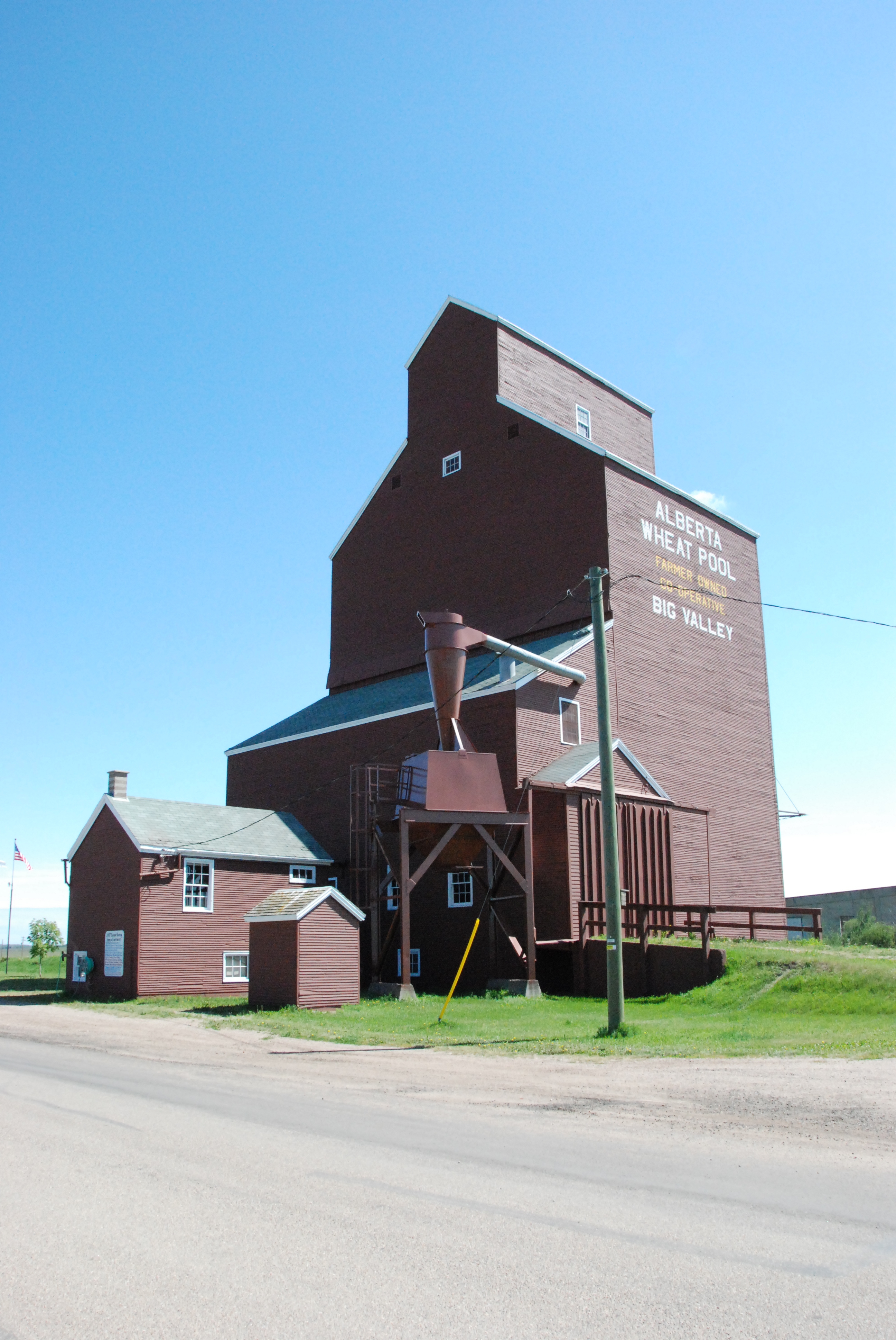
Alberta Wheat Pool Grain Elevator (DSC_5353 Historic Resources Management Branch).
Today’s blog post will no doubt please all of our railroad and grain elevator enthusiasts out there in the ether. On August 27, 2012, the Alberta Wheat Pool Grain Elevator in Big Valley was designated as a Provincial Historic Resource and added to the Alberta Register of Historic Places. This grain elevator has heritage significance due essentially to the fact that it is…, well, it’s a grain elevator. These once dominant, landmark structures in rural Alberta have become iconic symbols, speaking to the province’s agricultural, social and railroad transportation history. This particular elevator also contributes to the cultural landscape of Big Valley, aiding in the visual communication of the community’s history as one of the province’s busiest railroad divisional points.
Wood-cribbed grain elevators such as the Alberta Wheat Pool elevator in Big Valley were once a dominant presence in the lives of most rural Albertans. These imposing, structures stood out on the horizon and could be seen from miles around. They were essential facilities for the sorting, storage, and transportation of grains and, as such, they also served an important social function as meeting places for area farmers. Although there were some variations in elevator design, size and services, they remained consistently similar in basic design and form over the years. This Alberta Wheat Pool grain elevator was a relatively late addition, being built in 1960, but it shares much with its earlier predecessors, notably its vertical orientation, gable-roofed cupola, shed-roofed drive shed with earthen ramps and overall lack of fenestration.
View of the Alberta Wheat Pool Grain Elevator, Big Valley (DSC_2647 Historic Resources Management Branch).
In 1912, Big Valley had been selected as a divisional point on the Canadian Northern Railway’s (CNoR) Battle River Subdivision. At one point it possessed a large railyard and a number of important railroad maintenance facilities and storage areas for fuel, water and freight. Largely supported by the railroad, Big Valley was a bustling centre with a large population. In the late-1920s, Big Valley’s boom period came to an end when the divisional point was moved to Mirror on the former Grand Trunk Pacific Railway line.
Although the 1960 Alberta Wheat Pool grain elevator was built long after the Big Valley’s glory days as a divisional point, its presence adds to the interpretation of the community’s railroad heritage, particularly when considered together with the presence of other designated historical resources, such as the historic CNoR railway station and the remains of the roundhouse and frequent visits by the Canadian National Railways 6060 steam locomotive.
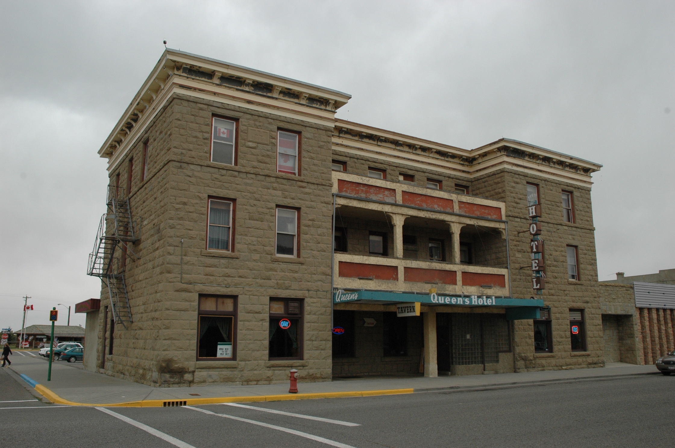
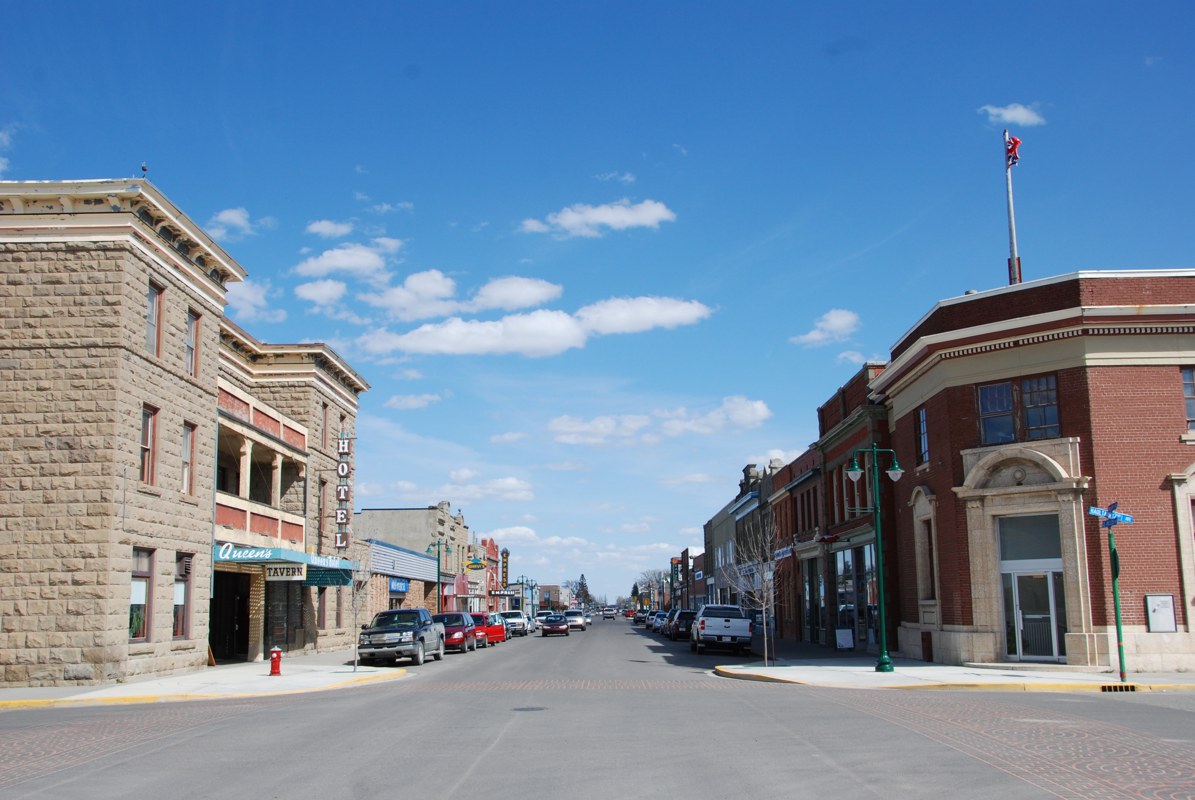
Mid-way through last year, the Queen’s Hotel in Fort Macleod was added to the Alberta Register of Historic Places. The Queen’s Hotel was designated as a Provincial Historic Resource on May 22, 2012. The building was deemed to possess heritage significance as it is an excellent example of the type of substantial hotels built in Alberta’s urban centres during boom periods of the late 1800s and early 1900s. The hotel also contributes to the heritage character of the Fort Macleod Provincial Historic Area.
The Queen’s Hotel, Fort Macleod, 2007. DSC_8336, Historic Resources Management Branch
Fort Macleod was one of Alberta’s earliest and most important urban centres during the settlement period. As a thriving commercial hub and service centre for the surrounding ranching and farming communities, a number of buildings were constructed in the town’s downtown area. Locally-quarried sandstone became the building material of choice, largely due to its fire-proofing properties and the sense of stability and permanence it lent to the business and town.
The Queen’s Hotel was one of the first buildings in Fort Macleod to be built of sandstone. It was built in 1903 to replace an earlier, smaller, wood-frame hotel of the same name. The hotel is a three-storey, flat-roofed building with a U-shaped footprint. It is a prominent building in downtown Fort Macleod, being located on the northeast corner of 24th Street and Second Avenue in the town’s main commercial district. It is constructed of rough-faced sandstone blocks and is crowned by a substantial, pressed metal cornice. On completion, the Queen’s Hotel was touted as Fort Macleod’s finest lodgings and it was the most expensive accommodations in town. The Queen’s Hotel quickly became the hotel of choice for travelling business people, politicians and government officials and other well-heeled visitors to the area.
The Fort Macleod Provincial Historic Area (Queen’s Hotel at left), 2010. DSC_1150, Historic Resources Management Branch
Like most small-town hotels, the Queen’s fortunes declined following the Second World War. As tastes in travel accommodations changed, the hotel became known more as a downtown tavern with low-cost rental apartments. The hotel has also undergone a number of alterations over the years, a substantial one-storey addition has been added to the rear of the building and, as is often the case in buildings of this nature, the layout of the main floor has been dramatically altered. However, the hotel’s sandstone construction and overall style and design continue to communicate its historical significance as an early, business-class hotel and it continues to serve as an impressive visual anchor to Fort Macleod’s historic commercial district.
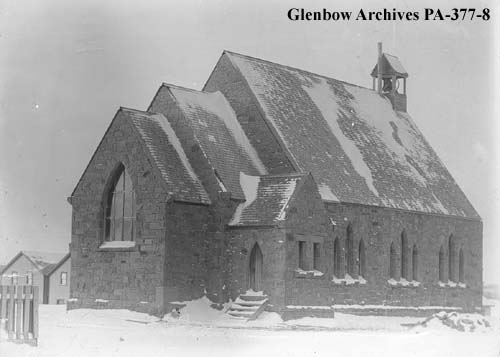
St. Luke’s Anglican Church, ca. 1906 (prior to the construction of the tower) PA-377-8, Glenbow Archives
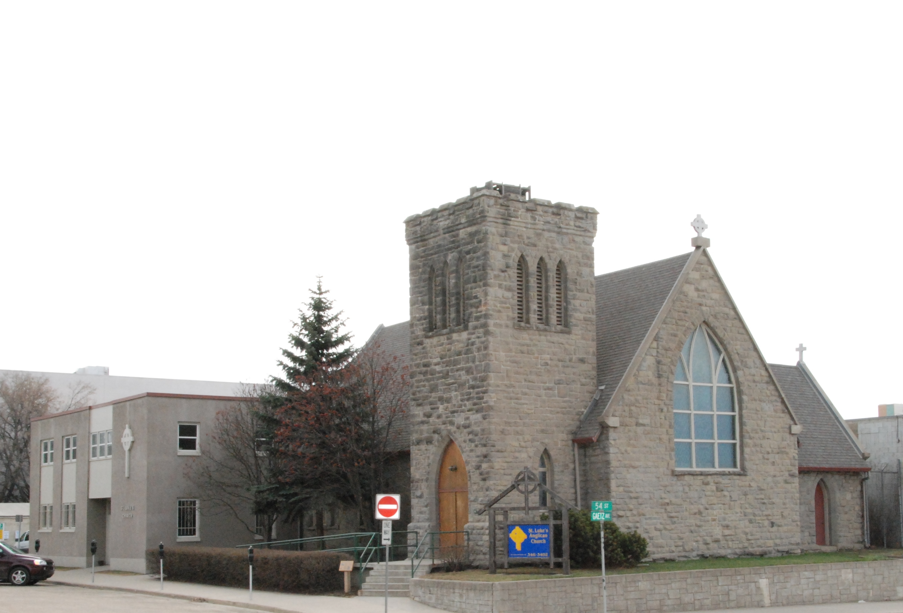
St. Luke’s Anglican Church in Red Deer is one of the more recent additions to the Alberta Register of Historic Places. St. Luke’s is significant due to its Gothic Revival style of architecture and the use of sandstone in its construction. The Government of Alberta previously designated the church as a Registered Historic Resource in 1978. The designation was revaluated and upgraded to a Provincial Historic Resource on August 27, 2012. St. Luke’s was also designated as a Municipal Historic Resource by the City of Red Deer in 2009.
(DSC-3460.jpg) View of the sanctuary and altar. Historic Resources Management Branch, 2008
The parish of St. Luke’s was formed in 1893. In 1899, Reverend Joshua Hinchliffe became the parish priest and proposed the construction of a new church at a central location in Red Deer. Construction, which was done in stages, began in the summer of 1899. The chancel and sanctuary were completed in 1900, followed by the nave in 1904 and vestry and tower in 1906. The church was built by an Edmonton-based firm, but it is very likely that Rev. Hinchliffe played a large role in the design. Hinchliffe had trained for the priesthood in England where he would undoubtedly have been influenced by architectural theories of the Ecclesiological Society. This group of Anglican theorists developed architectural guidelines for Anglican cathedrals and churches. Amongst other things, they strongly mandated the use of the Gothic Revival style, a clear definition between areas of the church and the use of natural materials, particularly stone walls with wood interiors and roofs.
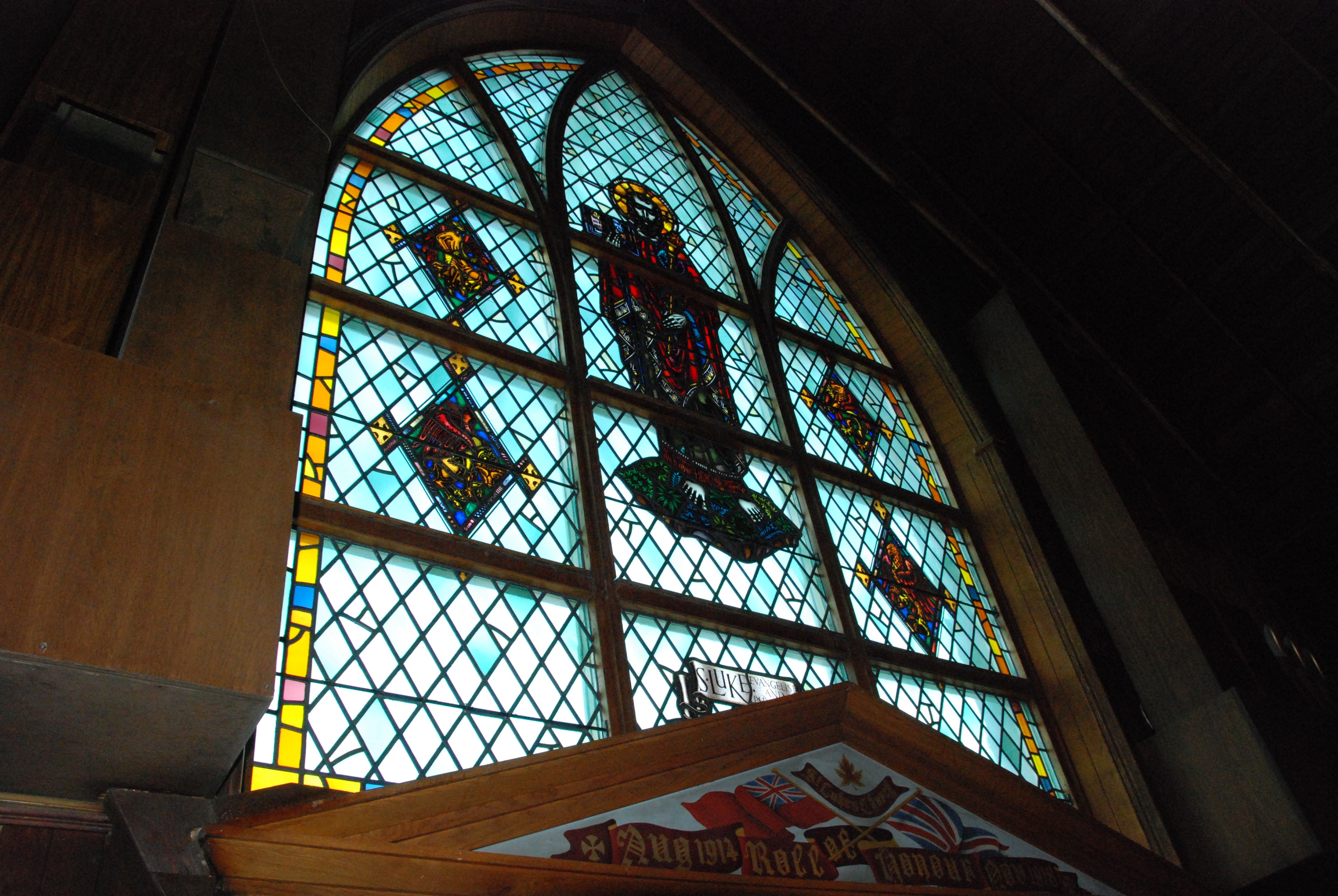
(Photo DSC_4871.jpg) Interior view of the west-facing stained glass window. Historic Resources Management Branch, 2009
St. Luke’s Anglican Church incorporates many of the design and construction elements characteristic of the principles mandated by the Ecclesiological Society. It is constructed of locally-acquired sandstone and features Gothic arches throughout. There is a clear demarcation between the sanctuary and nave and it is oriented on an east-west axis, with the altar to the east and the main entrance and tower to the west. Somewhat unusual in a province where most early churches were built of wood, St. Luke’s is a wonderful, if smaller than typical, example of an Ecclesiological Society-influenced church in Western Canada.
(DSC-4868a.jpg) View showing the west and north elevations. Historic Resources Management Branch, 2009
St. Luke’s Anglican Church remains in use as an active church and is the oldest actively-used church in Red Deer. More information on St. Luke’s can be found on the Alberta Register of Historic Places.
Written by: Ron Kelland, Historic Places Research Officer and Geographical Names Program Coordinator
Apparently we can use some kind of built in WordPress web analytics tool to find out which search terms people enter into their web browsers to arrive at RETROactive. Curiously, over the past few days, there have been a number of searches for the origin of the name Andrew, which is a village in east-central Alberta. There is nothing on RETROactive that will provide that information, so I figured I would make the origin of the name of the Village of Andrew the subject of this post. So, anonymous searching person, I don’t know if you are still out there, but This One’s For You!!!
Andrew is a village located in east-central Alberta, approximately 70 km northeast of Edmonton and 45 km NNW of Vegreville. The community is named for prominent, early resident Andrew Whitford, who was a member of the large Métis, Whitford family that resided in the vicinity of Victoria Settlement. The nearby Whitford Lake, Whitford Creek and the hamlet of Whitford are all named for the family.
Andrew Whitford was born about 1830. It appears that he worked as a freighter and travelled extensively throughout the North West Territories. In 1885, he served as a scout during the North-West Rebellion, for which he, along with other scouts and militia members, received two adjacent quarter sections of land. Whitford selected the SE and SW quarters of Section 32, Township 56, Range 16, West of the 4th Meridian. He was widely acknowledged as a leader in the community; issues of the Edmonton Bulletin note many instances of his support for local charitable causes and his frequent support for orphaned children and destitute families in the Star/Whitford/Andrew region through the late 1890s. He also served as a founding trustee and later treasurer of the local school district, which was established in 1895 and called, fittingly enough, the Whitford School District No. 393. In the spring of 1901, a small pox epidemic broke out in east-central Alberta. Andrew Whitford contracted the disease and passed away on April 26. A short obituary appeared in the May 3, 1901 issue of the Edmonton Bulletin:
Died, at Whitford on April 26th, 1901, Andrew Whitford, aged about 70 years of small pox and complications. The demise of Mr. Whitford removes from our midst a man of universal respect and an old land mark of the west who could tell many reminiscences of early life between old Fort Gary and Vancouver. He was a trusted and worthy scout of ’85, and saw much of the stirring rebellion. At his death he was treasurer of Whitford P.S.D., April 26, 1901.
Main Street of Andrew, Alberta, ca. 1930. Photograph by Nicholas W. Gavinchuk, Provincial Archives of Alberta, G208.
John Borwick, a long-time guide and early settler in the same region, operated a stopping house at NW28-56-16-W4, near the junction of the Winnipeg Trail and the Calgary-Pakan Trail. Following Whitford’s death, Borwick named the stopping house the Andrew Hotel, in honour of his friend and long-time compatriot. Alongside the Andrew Hotel was a store owned by Ed Carey. On March 1, 1902, a post office was established and given the name Andrew. Eliza Borwick, John’s wife, was the first postmaster. A small, but thriving rural community began developing around these three facilities.
In 1928, after much lobbying by area residents, the Canadian Pacific Railway built a line through the region and surveyed a town site at SE32-56-16-W4 on the north side of the tracks. The rural community of Andrew was located mostly on the neighbouring quarter section to the southeast. The Andrew Hotel, the post office, the store and most of the rest of the community moved to the new surveyed town site. Fittingly, the new town site of Andrew was located on one of Andrew Whitford’s original quarter sections. Two years later, on June 24, 1930, Andrew was erected as a village. According to 2011 Census of Canada, the Village of Andrew has a population of 379, down from 465 in 2006.
Written by: Ron Kelland, Historic Places Research Officer and Geographical Place Names Coordinator
Location
National Topographic System Map Sheet: 83 H/16 – Willingdon
Latitude/Longitude:
53° 52’ 42” N & 112° 20’ 07” W
Alberta Township System:
Sec 32 Twp 56 Rge 16 W4
Description:
Approximately 70 km northeast of Edmonton and 45 km NNW of Vegreville.
Additional Resources
More information about the Village of Andrew can be found in:
Andrew Historical Society, Dreams and Destinies: Andrew and District, (Andrew: Andrew Historical Society, 1980).
Cathy Chorniawy, Commerce in the Country: A Land Use and Structural History of the Luzan Grocery Store, (Edmonton: Alberta Culture, Government of Alberta, 1989).
(Photo 20060621_8707.JPG) View from the southeast, showing the Section House and the former rail yard. Historic Resources Management Branch, 2006
The Canadian Pacific Railway Section House in Coronation is the latest addition to the Alberta Register of Historic Places. The building was previously designated as a Registered Historic Resource in 2002. The resource was revaluated and its designation was upgraded to Provincial Historic Resource on August 27, 2012. The building, also known as the Section Foreman’s or Roadmaster’s House is significant as it is representational of CPR divisional point architecture and demonstrates the type of housing provided by the railway to essential railway employees.
(Photo 20060621_8714.JPG) View from the southwest (trackside). Historic Resources Management Branch, 2006
Coronation, which is located about 120 km east of Stettler, became the divisional point for the CPR’s Lorraine subdivision, which eventually connected Youngstown in the south and the coal mines at Halkirk in the north to the main line. The Section Foreman was responsible for track maintenance on the subdivision. The CPR believed that men with established families were better qualified for positions of responsibility and housing was often provided for them as a way of attracting and retaining such people. At one point Coronation had three section houses in a line adjacent to the town’s rail yard. These houses were built according to a CPR standard plan, and were utilitarian in nature and featured simple ornamentation and were constructed of low-maintenance materials.
With changing technology, the use of divisional points evolved and many section houses were either abandoned, lifted and moved or simply torn down. The Coronation section house, which is now used as a local museum, remains on its original site and effectively communicates its provenance as an essential, and often over-looked, element of railway infrastructure.
In Part 1, we read about “Lee’s Creek,” as mentioned in Corb Lund’s song “The Truth Comes Out” and how Lee Creek in the Cardston area is named for early pioneer William Samuel Lee. So, what’s up with the different spelling? Is it Lee Creek or Lee’s Creek? It may actually be both. Confused? Read on for more.
Even though Lee only lived on the creek named for him for about three years (1867-1870), the name stuck. A map produced by the Geological Survey of Canada in 1884 identifies the creek as “Lee’s Creek.” In 1894, the name “Lee Creek” (without the possessive apostrophe) was recorded by the Dominion Land Survey in the field notes of surveyor Fred W. Wilkins and in the diary of Arthur O. Wheeler (for more about Wheeler see the St. Nicholas Peak post of December 22, 2011). In 1901, the Geographic Board of Canada approved the non-possessive form of the name – Lee Creek – for use on official maps. The portion of the creek south of the 49th parallel remained officially unnamed until 1929, when the United States Board on Geographical Names (USBGN) sanctioned the name Lee Creek for their portion of the water feature.
So why the different spellings of Lee/Lee’s Creek? The use of the possessive form of words in place names is generally discouraged. Some of the rationales for not using the possessive form of names are that geographical features do not belong to a single person or group, but to all people; that place names are not words with a specific dictionary meaning, but are labels to which standard grammatical rules do not necessarily apply; and that the presence of apostrophes cause confusion, particularly when attempting to retrieve names in modern databases, internet search engines and directional software used by emergency services (police, ambulance, fire). There is also a belief (likely apocryphal) that apostrophes were not used on early maps because they were often confused with the standard cartographic notation indicating the presence of stones and rocks.
Lee Creek with a Kainai (Blood) encampment in the distance, taken near Cardston, 1898.
The USBGN and the Committee for Geographical Names in Australia both have policies prohibiting the use of the possessive apostrophe in the official names of geographical features. Many naming regulatory bodies in the United Kingdom have been eliminating apostrophes from their official names. Canada and Alberta also discourage the use of the possessive apostrophe, however Principle 5(A) of Alberta’s “Principles of Geographical Naming” does allow for the use of possessive forms if it can be demonstrated that form of the name is in long-standing local use.
However, despite all of the official naming standards and policies, local names and forms die hard. In the case of Lee Creek, even more than 110 years after that form of the name was officially adopted the locals still refer to it as “Lee’s Creek. When asked if the Lee Creek on the map was the same as the Lee’s Creek in his song, Corb Lund replied
Yup. Same one. It flows right through our ranch near Beazer. I grew up swimming and fly fishing it. My Grandpa, whose father homesteaded the place, called it “Lee’s Creek.” “Lee’s Crick to be really precise, but I’ve seen it called “Lee Creek.” In my experience, the locals I knew called it “Lee’s” and the book name was always “Lee,” but your mileage may vary…
At the end of the day, whatever the form the name takes, Lee (or Lee’s) Creek, the creek and its name continues to commemorate one of Alberta’s earliest pioneers.
SW ¼, Sec 23 Twp 3 Rge 25 W4 (at confluence with St. Mary River)
Description:
Flows generally north-easterly from the border for approximately 65 km (35 km straight line) until it joins the St. Mary River just north of the Town of Cardston
Additional Resources:
More information about and images of Lee Creek and William Samuel Lee can be found in:
C. Drain, “Lee, William – The Pass was his Bull Run,” Crowsnest and its People, 2nd printing, (Coleman: Crowsnest Pass Historical Society, 1980), 662-663
The inspiration for some of these blog posts comes from the darndest places and some have extremely long gestation periods. Such is the case with this one.
William Samuel Lee, ca. 1900
Place names have a long history of being used in popular music. While American references abound, finding songs that mention Alberta, or even Canadian places or names are much harder to find. It seems that people would rather leave their heart in San Francisco than in Sangudo or spread the news about New York rather than New Sarepta. But if you look hard enough, there are examples of Alberta place names used in songs.
It was early January 2012. I was desperately trying to get the once enjoyable, but now overplayed and cloyingly sentimental tones of Bing Crosby and Nat King Cole from running through my head like the soundtrack to some never-ending, slightly demented holiday television special. So, I popped one of my favourite CDs into the player and the wonderful sounds of Corb Lund and the Hurtin’ Albertans started emanating from my speakers. The disc eventually came around to Track 8, “The Truth Comes Out.” Now, the house is pretty quiet, and I am listening to the lyrics much more closely than I otherwise might, and I hear:
You gotta’ look out for bear when you’re fishing on Lee’s Creek
They come ‘round the bend and they’ll make your knees weak
There’s grizzlies where there was no grizzly bears before.
Now, I know that Corb Lund is from southern Alberta and even though I am the names guy, I am not all that familiar with the southern reaches of the province. After mulling over the song for awhile, I start to wonder if there really is a “Lee’s Creek.” So, I fire up the old Alberta Geographical Names Database and sure enough there is a “Lee’s Creek,” or more properly there is a Lee Creek (more on that in a moment) in southern Alberta. It is a substantial creek with an interesting history.
Lee Creek is located in south-western Alberta. It rises within Montana’s Glacier National Park and flows generally north-easterly, crossing into Canada about 16 kilometres west of the Carway, AB / Peigan, MT border crossing. It continues to meander generally north-easterly for about 60 km (35 km as the crow flies), passing through the Town of Cardston before joining the St. Mary River in Section 23, Township 3, Range 25, West of the 4th Meridian (approximately 60 km south-west of Lethbridge).
The creek is named for William Samuel Lee. According to a local history of the Crowsnest Pass region, Lee was born in England at about 1830. As a young man, he migrated to the United States and worked in New York and Ohio before making his way to California hoping to make his fortune in the gold rush. Like most prospectors, Lee’s hopes of quick wealth in the gold fields were disappointed and he headed north to Fort Benton, Montana District to try his hand at fur trading. In 1867, Lee crossed the border into Rupert’s Land where he came upon a well-used ford across a substantial creek. He established a small trading post beside the ford (just west of present-day Beazer). The creek soon became known as “Lee’s Creek.”
Lee did not stay long on the creek named for him; he moved to the Pincher Creek area in 1870 and began ranching. He squatted on land along the shores of a lake (Lee Lake, go figure) about three km south east of present day Burmis. A few years later, Lee was evicted by the Hudson’s Bay Company and he moved his ranch, buildings and all, to a site north of Burmis. Lee is an important figure in the history of the Crowsnest Pass. He is considered to be the first non-native resident of the Pass; he discovered sulphur springs near present-day Frank; opened a boarding house; and built the region’s first school. William Lee spent the rest of his life in the Crowsnest region; he died of pneumonia in 1896.
SW ¼, Sec 23 Twp 3 Rge 25 W4 (at confluence with St. Mary River)
Description:
Flows generally north-easterly from the border for approximately 65 km (35 km straight line) until it joins the St. Mary River just north of the Town of Cardston
Additional Resources:
More information about and images of Lee Creek and William Samuel Lee can be found in:
C. Drain, “Lee, William – The Pass was his Bull Run,” Crowsnest and its People, 2nd printing, (Coleman: Crowsnest Pass Historical Society, 1980), 662-663
Aerial View of Zama City, looking south. Photograph courtesy of Curtis Johnston.
Much of Alberta’s natural resource wealth is found in the northern parts of the province, but despite the importance of our northern reaches, many of us do not often think about the north until we are somehow forcibly reminded to do so. One of these moments occurred on Thursday, July 12, 2012 when much of north-western Alberta was blanketed with smoke. People in Edmonton awoke to hazy skies and the unmistakable smell of smoke in the air. So, where did this smoke come from? Most were surprised to hear that it came from a massive forest fire near Zama City, about 700 km north.
News reports about the fire and its location had people asking “Zama City? Where is Zama City? And what kind of name is that anyways?”
Zama refers to a place and a few geographical features. These names are presented in order of their official adoption.
Zama River
The Zama River rises in the wetlands around Bootis Hill about 30 km northwest of Zama City and flows generally south for approximately 85 km before entering Hay Lake. The river was named by Ernest Wilson Hubbell of the Dominion Land Survey. Hubbell was born in Brockville, Canada East (later Ontario) in 1862. He joined the military and served as a Lieutenant during the Riel Rebellion, following which he attended the Royal Military College in Kingston, graduating in 1881. A few years later, he was employed by the Dominion Land Survey.
As chief of a survey party, Hubbell traveled extensively throughout western Canada. He recorded the name “Zammah River” in his 1921 field notes. That same year, Hubbell drew a map of Hay Lake. On this map he notes the “Zamah River” being on average two chains wide, four feet deep, having a current of two mph and flowing through muskeg and swamp. He also notes an “Indian trail” on the river’s west side. In a letter dated 21 March 1922 to the Geographic Board of Canada (GBC), Hubbell noted that “[d]uring the season of 1921, I traversed Hay Lake, Northern Alberta, and named rivers … being unable to identify those streams with any others previously recorded.” He further explained that the name “Zammah [is] the transliteration of the name of the Slavey Chief whose trail follows up this river.” The GBC accepted the name during its 4 July 1922 meeting, but altered the spelling to Zama River; no explanation being given for the alteration.
Other surveyors have also commented on the river, notably B. M. Rustad in 1965, who noted in Section 34 of Township 116-7-W6, that the Zama River was 13 feet wide and flowed through “gently undulating country well stocked with Poplar and Spruce to 12 inches diameter, Willow and Alder.” The Dene Tha’ people (formerly known as the Slave or Slavey Indians) identify the river by the traditional name Kólaa Zahéh, which translates as “Old Man River.” There is some thought that this may be a reference to Dene chief Zamba or Zammah referred to by Hubbell, but it is more likely to be a reference to First Nations spirituality and creation stories.
Location
National Topographic System Map Sheet: 84 L/15 – Habay
Latitude/Longitude:
59° 15’ 11” N & 119° 10’ 58” W (approximate location of head waters) to
58° 31′ 38″ N & 118° 50′ 13″ W (at point of entry to Hay Lake)
Alberta Township System:
Sec 18 Twp 118 Rge 7 W6 (approximate location of head waters) to
Sec 31 Twp 113 Rge 5 W6 (at point of entry to Hay Lake)
Description: Generally south for approximately 85 km (47 km strait line) until it enters Hay lake about 50 km NE of the Town of Rainbow Lake and 105 km WNW of the Town of High Level.
Zama Lake
Zama Lake is located about 50 km southwest of Zama City. The lake also appears to have been named by E. W. Hubbell, DLS. Oddly, the Zama River does not directly enter Zama Lake; Zama Lake and Hay Lake are connected by a substantial wetland. Although the name for both the river and lake were recorded in 1921, the name Zama Lake was not officially adopted until November 6, 1944. The Dene Tha’ do not use the name Zama Lake, but use traditional names to identify the lake. Some of the Dene Tha’ use the name K’ah Woti Túé, which translates as “Main Blind Lake” (referring to a hunting or duck blind). The Dene around Assumption on the Hay Lake Reserve identify the lake with the name Tulonh Mieh, which translates as “Where the Water Ends.” This is thought to be a reference to the lake being the western-most of the Hay-Zama Lakes group.
Location (approximate centre of lake)
National Topographic System Map Sheet: 84 L/11
Latitude/Longitude: 58° 45’ 00” N & 119° 05’ 00” W
Alberta Township System: Twp 112 Rge 7 W6
Description: Approximately 25 km NE of the Town of Rainbow Lake and 115 km WNW of the Town of High Level.
Zama Lake Indian Reserve No. 210
The Zama Lake Indian Reserve No. 210 is an irregularly-shaped, 2,307 hectare (5,700 acre) reserve located just west of Zama Lake. The reserve is one of seven administered by the Dene Tha’ people. The Zama Lake reserve was created by provincial Order-in-Council No. 547/50, which was signed on May 15, 1950. To “enable Canada to fulfil its obligations under the treaties with the Indians of the Province” the order set aside the land, and transferred title to the Dominion of Canada, to be known as the Zama Lake Indian Reserve No. 210. This transfer was confirmed by Order-in-Council 594/50, which was signed on May 22, 1950. There are no official or permanent settlements on the reserve and it is administered from the band office at Chateh on the Assumption reserve about 30 km to the east.
Location (approximate centre of reserve)
National Topographic System Map Sheet: 84 L/11
Latitude/Longitude: 58° 44’ 12” N & 119° 14’ 27” W
Alberta Township System: Twp 112 Rge 8 W6
Description: Approximately 23 km NE of the Town of Rainbow Lake and 115 km WNW of the Town of High Level.
Zama City
Imperial Oil Seismic Crew in the Zama Lake/Rainbow Lake Region, Summer 1950 Glenbow Archives (S-236-46) .
Zama City is a hamlet administered by Mackenzie County. It is located approximately 115 km in a straight line (150 km by road) northwest of High Level. It is a service centre for the Zama oil field, which is possibly the largest oil and gas field in the province. According to the 2011 Census of Canada, there are 93 permanent residents in Zama City, but the hamlet often supports a transient workforce population approaching 4,000 people.
The oil fields of the Zama region were discovered between 1965 and 1969. It is unclear exactly when the community was founded. The 1:250,000 NTS Map for the region (Bistcho Lake) produced in 1963 shows the nearby airfields, but no town site. A local history of the High Level area, Notes of the North,published in 1977, suggests that a small community had been established by 1968. It may have been originally known as “Cameron Corner” after an early oil company, but soon became known as Zama City, after the nearby lake and river and the oil field it depended on (It is assumed the “city” was intended as irony). The name of the community was officially recognized as Zama City on September 10, 1980. Although still a relatively isolated northern outpost, Zama City boasts most of the services and facilities one would expect to find anywhere in the province.
In mid-July, 2012, a massive forest fire near Zama City threatened the community, coming within 10 km of the hamlet. Residents of Zama City were evacuated on Wednesday, July 11. The fire was held off and the evacuation order was lifted on July 20, allowing residents to return to their homes.
Location
National Topographic System Map Sheet: 84 M/02 – Moody Creek
Latitude/Longitude: 59° 09’ 09” N & 118° 40’ 50” W
Alberta Township System: Sec 7 Twp 112 Rge 4 W6
Description: Approximately 115 km NE strait-line of the Town of High Level (150 km by road).
Hay-Zama Lakes Wildland Provincial Park
The Hay-Zama Lakes Wildland Provincial Park is a large park that encompasses the wetlands surrounding Hay Lake and Zama Lake. The park is 486 square kilometres (188 square miles) in size and is made up of a complex network of rivers, creeks, lakes, floodplains, and muskeg. The wetlands are on three of the four major duck migration roots and are a significant habitat for numerous other types of waterfowl and furbearing mammals. The park is also serving as a re-introduction site for wood bison. In 1982, the Hay-Zama Lakes wetland was recognized as a Wetland of International Importance under the Ramsar Convention on Wetlands, which has been promoting wetlands conservation since 1971. The Hay-Zama Lakes Wildland Provincial Park was created by Order-in-Council 202/99, which was signed on May 5, 1999.
Location (approximate centre of park)
National Topographic System Map Sheet: 84 L/15
Latitude/Longitude: 58° 45’ 56” N & 118° 58’ 53” W
Alberta Township System: Twp 112 Rge 6 W6
Description: Approximately 37 km NE of the Town of Rainbow Lake and 105 km WNW of the Town of High Level.
Written by: Ron Kelland, Historic Places Research Officer and Geographical Names Program Officer
Additional Resources:
More information about these Ernest Hubbell and the Zama group of geographical features and places can be found at:
The Clear Hills Watershed Initiative’s Lake and Creek Names Research Project
The Clear Hills Watershed Initiative is working on a research project to uncover the local, historical and traditional names used by area residents to identify the creeks and lakes in their region. The Initiative is concerned with water use and quality, and educating the residents of the region about the local water supply. The Initiative believes that researching the names of their creeks and lakes and disseminating that information will raise the profile of these creeks and lakes and will increase the pride and value that people place on these resources.
Volunteers of the Clear Hills Watershed Initiative naming project making research notes on maps of the region. Eureka River Hall, March 31, 2012.
The Alberta Geographical Names Program was first approached by the Clear Hills Watershed Initiative in 2010 when they were seeking information on having new geographical names officially adopted. The group has been actively interviewing many of the older residents of the region, with particular attention to the trappers, First Nations people and the men and women who have lived and worked in the backwoods of that section of northern Alberta. What the researchers are discovering is that although many of the creeks and lakes in Clear Hills County are not officially named on maps, there are numerous local and historical names used to identify them. The researchers are also discovering the origin stories behind some of the existing official names. These names are often descriptive of the feature’s physical characteristics or commemorate original settlers or trappers that have worked in the area. In all these, local and historical names shed some light on the history of the Clear Hills region.
Sherri Larsen, organizer of the group and a driving force behind the naming project, invited me to attend a meeting of the Initiative’s naming group and to speak at a community supper held at the Eureka River Community Hall on March 31, 2012. What I saw when I arrived was a group of people who are proud of their heritage and who are dedicated to uncovering as much of that heritage as they can while the sources, many of whom are senior citizens, are still able to relate their knowledge. People with knowledge of the region’s back country and waterways are identified and interviewed. Notes are taken about the names they use to identify water features and these names are then annotated on the appropriate 1:50,000 NTS Map Sheets for the region.
At the community dinner these maps were laid on large tables for viewing. As people came into the hall, a number of them drifted over to the map table and made comments on what was named and what wasn’t. Spirited discussion often followed about what such-and-such a creek or lake was named and who had had their trapping cabin on it or which forestry road went by.
Following dinner I gave a short speech to the assembled residents focused on the importance of geographical names as navigational aids and reminders of our heritage. However, with all of my degrees and experience the importance of the Clear Hills Naming Project was succinctly summed up by a junior high school student, who presented a school project about his favourite place in the county. For him this was “Stoney Lake” (officially named Montagneuse Lake). He remembered important gatherings of family and friends and other members of the community at the recreation area on this lake and that lake and those events made him feel connected to his community. He also said that he was able to get most of his information about the lake from his grandfather.
That in essence sums up the role of place names – they are more than navigational aids and points on a map. They represent our community values and history. The knowledge of many of these names and the origin stories behind them lie with many of the older members of our community.
Following the speeches, even more people found their way to the maps and more comments were made, more creeks were identified and more stories were exchanged. As with most community-based heritage, people often believe that they do not have any knowledge of any value or interest; that nobody wants to know what it was like so many years ago. However, it is usually the people who believe that they have nothing interesting to tell that possess the most valuable information of all. It is important for this knowledge of the past to be passed on to the next generation. The volunteers working on the Clear Hills Naming Project are seeking to record this naming and community heritage while the opportunity is still there.
As the Clear Hills Watershed Initiative uncover more historical and local names for their creeks and lakes, they hope to submit them to the Alberta Geographical Names program to be officially adopted. Keep checking this blog, there should be many more interesting names and stories coming out of Clear Hills County in the near future.
Since the March meeting, the Naming Project has acquired the services of a researcher, Dallas Bjornson. Dallas will be spending most of the summer talking to people and recording their stories about the water features in the area. If you can assist the volunteers of the Clear Hills Watershed Initiative in their geographical names research, they would be pleased to hear from you. Contact information can be found at the Initiative’s website under the “Naming Our Creeks and Lakes” link on the website’s main page.
The 100th anniversary of the Calgary Exhibition and Stampede came to a close this past Sunday, July 15, 2012. Today’s blog post will complete the short series about the Big Four and the geographical features named for them. The Big Four were the ranchers and businessmen that funded Guy Weadick’s 1912 wild west show and rodeo, which grew to become today’s Calgary Stampede. Part One of our series was posted on July 10, 2012 and featured Stavely area rancher George Lane and Lane Creek; Part Two was about A. E. Cross and Cross Creek. Today’s post will feature Calgary-based rancher and industrialist Patrick Burns.
Pat Burns: Rancher, Businessman, Industrialist and Senator
Senator Patrick Burns
Pat Burns is arguably the most successful and well-known of the Big Four. Pat Burns was born and raised in the Lake Simcoe region, near Oshawa, Canada East (later Ontario) in 1856. He migrated west in 1878 and tried his hand at homesteading in Manitoba. While homesteading, he acquired some oxen and hired himself out as a freighter. He also dabbled in livestock trading. Encouraged by the Canadian Pacific Railway, which wanted to prove the viability of long-distance livestock shipments, Burns bought six carloads of hogs and had them shipped east; the venture was profitable. Seeing greater opportunities in livestock trading, Burns abandoned the homestead in 1885 and began trading cattle full-time.
In 1887, Burns was contracted to provide meat to railway construction camps, and within two years he was supplying camps from Maine in the east to Calgary and Edmonton in the west. He established a slaughterhouse in Calgary in 1890 and established a ranch, the first of many, near Olds the following year. In 1902, Burns acquired from William Roper Hull a chain of retail stores and the associated the Bow Valley Ranche (now a Provincial Historic Resource) on Fish Creek south of Calgary. Burns’ company, P. Burns and Co., soon became one of Canada’s largest meat-packing companies, with production facilities and retail stores across the west. It also maintained up to 45,000 head of cattle on numerous ranches in central and southern Alberta, including the Bar U and the Flying E, which were acquired following the death of George Lane in 1927. Burns diversified his company’s investments by successfully expanding into dairy production and fruit and dry goods distribution and, less successfully into the American dairy market and into coal and copper mining and oil and gas exploration.
Burns was active in the community and was a noted philanthropist, providing funding to schools, hospitals, orphanages, old-age homes and widows’ funds. He was also known to send train loads of food to disaster stricken areas. Burns, a supporter of the Liberal Party, was appointed to the Canadian Senate by Conservative Prime Minister, R. B. Bennett; Burns sat as an Independent from 1931 until 1936, when he retired due to health reasons. Pat Burns died on February 24, 1937 at Calgary.
Two geographical features in Alberta are named directly for Patrick Burns, although four features bear his name (Confused? Bear with me).
Mount Burns
Mount Burns is an approximately 2,940 metre (9635’) mountain on the north side of the Sheep River about 40 km west of Turner Valley. In the 1910s, coal had been discovered in Sheep River Valley below this mountain and, in 1913, Pat Burns invested in a coal mine alongside the river. According to historian Grant MacEwan, Burns visited the mine site frequently. The Geological Survey of Canada recommended that the mountain be named Mount Burns, due to the nearby mine and its association with the Calgary businessman. The name was officially adopted by the Geographical Board of Canada On May 2, 1922 and began appearing on federal government maps, such as the 1926 Calgary Sectional Sheet, soon after that.
National Topographic System Map Sheet: 82 J/10 – Mount Rae
Latitude/Longitude: 50° 38’ 39” N & 114° 51’ 40” W
Alberta Township System: Sec 26 Twp 19 Rge 07 W5
Description: On the north side of the Sheep River Valley, approximately 40 km west of The Town of Turner Valley
Burns Creek
Burns Creek flows off the eastern slopes of the Mount Rae/ Mount Arethusa massif. The creek flows south-easterly off the mountain face into the northern end of a small, high altitude lake (Burns Lake) approximately 1.7 hectares (4.25 acres) in size. The creek exist the south side of the lake and proceeds south-east and then north-east until it meets Rae Creek to form the Sheep River. The creek is approximately eight km in length.
Not much is known about the naming of Burns Creek. The creek is named on the 1926 Calgary Sectional Sheet and it is most certainly named due to its association with the nearby mountain and coalmine. Mountains often lend their names to associated geographical features, such as creeks and lakes. Typically, these creeks run directly off the mountain. For example, Storm Creek runs off Storm Mountain and Warspite Creek runs off Mount Warspite. However, in the case of Burns Creek, the creek is not directly associated with Mount Burns, but is located on the opposite side of the sheep River Valley.
National Topographic System Map Sheet: 82 J/10 – Mount Rae
Latitude/Longitude: 50° 37’ 00” N & 114° 57’ 58” W (approximate location of head waters) to 50° 37′ 25″ N & 114° 53′ 25″ W (at confluence with Rae Creek and Sheep River)
Alberta Township System: SW ¼, Sec 19 Twp 19 Rge 7 W5 (approximate location of head waters) to NS ¼, Sec 22 Twp 19 Rge 7 W5 (at confluence with Rae Creek and Sheep River)
Description: Flows off the east face of Mount Rae and Mount Arethusa for eight km until it meets Rae Creek to form the Sheep River about 45 km west of the Town of Turner Valley.
Burns Lake (1)
Burns Lake is both fed and drained by Burns Creek. It was not officially named until the 1980s. In the mid 1980s, Alberta Fish & Wildlife made plans to stock this lake with fish. Information about the lake would be published in the stocking program’s reports and possibly in tourist and angling literature. A Fish & Wildlife officer familiar with the region recommended that the name Burns Lake be officially adopted. This proposal met with the approval of the Citizens’ Action Committee on Kananaskis Country on March 5, 1985 and by the Alberta Historical Resources Foundation on November 14, 1986 and by the Minister of Culture on May 5, 1987.
National Topographic System Map Sheet: 82 J/10 – Mount Rae
Latitude/Longitude: 50° 36′ 16″ N & 114° 56′ 38″ W
Alberta Township System: Sec 29 Twp 31 Rge 27 W5
Description: On the south side of the Sheep River Valley, approximately 47 km west of the Town of Turner Valley.
Burns Lake (2)
The second Burns Lake in Alberta is located near the Town of Olds. It is approximately 22 hectares (54 acres) in size. It is located in the County of Mountain View, about 25 km south east of the Town of Olds and 22 km east of the Town of Didsbury. Pat Burns operated ranches in the general vicinity of this lake. In 1922, S. L. Evans of the Dominion Land Survey recorded the name of the lake as Burns Lake on the plan he drew for Township 31-27-W4. The name was officially adopted by the Geographic Board of Canada for mapping purposes on January 20, 1955.
National Topographic System Map Sheet: 82 P/12 – Lonepine Creek
Latitude/Longitude: 51° 41′ 13″ N & 113° 48′ 09″ W
MacEwan, Grant, Pat Burns, Cattle King, (Saskatoon: Western Producer Prairie Books, 1979)
Archie McLean
You may have noticed that this is a series about the Big Four, yet there were only three parts, George Lane and Lane Creek; A. E. Cross and Cross Creek; and Pat Burns and Mount Burns, Burns Creek and two Burns Lakes. What about the other member of the Big Four?
The other member of the Big Four that funded the Calgary Stampede was Archibald “Archie” McLean. McLean was arguably just as successful as his three contemporaries, he was a successful rancher in the Taber and Fort Macleod regions, was elected to the Legislative Assembly of Alberta in 1909, 1913 and 1917. However, unlike his three contemporaries, there are no geographical features named for Archie McLean. A bridge on Highway 864 crossing the Oldman River just outside of Taber is named for him (49° 48’ 48”N & 112° 10’ 15”W) and there is a small lake just east of Lethbridge that is locally known by some as “McLean Lake” (49° 41’ 47” N & 112° 45’ 22” W).
For information about Archie McLean can be found on a recent blog post by Lethbridge’s Galt Museum & Archives, which can be accessed at:


")


")


")
")
