Okotoks Big Rock – Managing Vandalism with Technology

The word ‘Okotoks’ translates from the Blackfoot language as ‘Big Rock.’ The name was given by the resident indigenous people to a very large boulder that is known as a glacial erratic – boulders that have been moved from their original location by glacial ice. Okotoks is by far the largest erratic in Alberta; it is about the size of a two-story house and is estimated to weigh nearly seven million kilograms. The Big Rock is a well-known landmark in southern Alberta. It is a designated provincial historic resource owned by the Government of Alberta, and is accessible to the public by means of a hiking trail, signage and a parking lot. What is not well-known is that the Okotoks Big Rock has a great deal of Aboriginal rock art painted on its surfaces.

Okotoks Big Rock Erratic

Rock art includes pictographs (paintings) made with a red paint composed of iron-rich hematite (red ochre). The existence of a few red ochre images on the Big Rock has been known for decades, but the revolution in digital photography and image enhancement has brought to light a whole lot more art on the Okotoks erratic than previously known. Specifically, we now know that some areas of the rocks were extensively rubbed with red ochre. Since these red areas lack definable rock art figures like humans and animals, it was long believed that the red blotches were simply part of the rocks’ natural colour. Through enhancement we can now pick out hand prints and finger swipes, telling us these red blotches were indeed made by human beings.

Rock art at Okotoks Big Rock
Photo-enhanced areas of red ochre smeared on Okotoks Erratic. Note hand prints at top.

All rock art sites are sacred to Native people; rock art represents communication between human beings and the spirit world. Blackfoot people still visit the Okotoks site, conduct ceremonies, and hold the site in great reverence. Thus, it is all the more sad and frustrating that the Okotoks erratic has been subjected to extensive and increasingly frequent bouts of vandalism. As the site is operated by the province and is open to the public, there comes a point where some action needs to be taken. It is an eyesore, an embarrassment and severely disrespectful to the Blackfoot beliefs about the sacred character of the rock. But what can be done with a massive rock surface covered with graffiti that underneath lies fragile, precious painted pictures that tell stories of ancient Aboriginal people?

In the past few years, serious incidences of graffiti were washed off the rock face using a high pressure water sprayer. More recently, an environmentally friendly paint stripper had been used with good success. But critical to any graffiti removal has been potential impact to underlying rock art. We realized that we could never properly manage the site until we had a high-quality “map” of the rocks that plots the complex rock structure and the locations of all the rock art images. We realized that the best way to make a physical record of the Big Rock was to record it in 3D using a portable laser scanner. While documentation won’t stop vandalism at Okotoks, it will make us much better prepared to deal with future instances in a way that protects significant historical resources.

This slideshow requires JavaScript.

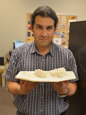
A partnership with the internationally respected organization CyArk was formed. CyArk is a nonprofit organization dedicated to digital recording and preservation of the world’s most significant sites. Among their credits are 3D recordings of the statues of Easter Island, Pompeii, ancient Thebes, and Mt. Rushmore. CyArk also digitally stores the 3D information for each site, serving as a world archive of heritage data. CyArk retained a local service provider to assist with the equipment and expertise to conduct the laser scanning. In early October 2013 the entire external surface of the Okotoks Big Rock, including the tops of the rocks and some internal crevices, was scanned during two days of field work. The result is a strikingly accurate rendering of the Okotoks erratic in both its geometric shape and the plotting of all known rock art images. The project also resulted in production of an accurate 1:200 scale model of the Rock that will be useful for planning and educational purposes.

3D rendering of point cloud data from laser scan at Okotoks with enhanced photography overlaid. Red areas are red ochre paint; note square-bodied human figure at upper left.

In addition to the rendering and scale model, the project also raised awareness about negative impacts associated with graffiti and heightening understanding of the value and importance of historic resources to the community. Further Alberta Culture now has a sophisticated tool to use for site management.

Alireza Farrokhi holding 1:200 scale model of the Big Rock

Sadly, the rocks have already been subjected to more graffiti in the months since our project ended; however, we now have accurate information on the type and location of rock art that will assist in graffiti removal efforts. There are other threats to the cultural and natural significance of the Okotoks erratic. It has long been a favoured place for climbers, subdivisions are rapidly encroaching on the site, and public visitation is increasing. There are many challenges ahead in the long-term management of the Big Rock, but thanks to the careful recording conducted through Innovation Program funding we have a solid baseline of information about this very special place that will guide future management.

Written by: Jack Brink, Curator, Royal Alberta Museum and Alireza Farrokhi, Head of Conservation and Construction Services, Historic Places Stewardship


Icons of Lethbridge’s historic Chinatown

Bow On Tong entraceway (2014.04.17)

The Bow On Tong Building and the Manie Opera Society Building are two well-known places in downtown Lethbridge that contribute to the distinctive cluster of buildings that make up Lethbridge’s Chinatown district. Recognizing their remarkable history and exceptional significance, the City of Lethbridge’s council recently designated each as a Municipal Historic Resource. The buildings are now undergoing comprehensive rehabilitation, including extensive structural repairs and the careful retention of historic elements found nowhere else in Alberta. I had the opportunity to visit these fascinating places just before Easter, gaining a glimpse into Lethbridge’s Chinese community during the first half of the last century.

Ted Stilson showing me Apothecary's showroom and work area. (April 17, 2014)
Ted Stilson showing me Apothecary’s showroom and work area. (April 17, 2014)

A 1907 City bylaw restricting all laundries to this area was enforced only if the laundry was Chinese-owned. Other Chinese-owned businesses followed the laundries into the neighbourhood west of Galt Gardens. The Bow On Tong was constructed in 1916 in the middle of the city block known as Chinatown, on 2nd Avenue South. Beside it stood the Manie Opera House Building (not its original name), built about a decade previously. Lethbridge’s Chinatown had begun.

The basement of the Bow On Tong Building in the middle of rehabilitation (April 17, 2014)

My tour of the buildings started on the main floor of the Bow On Tong and was led by Ted Stilson, coordinator of Lethbridge’s Main Street Program, and Kevin Peterson, general contractor for the rehabilitation project. I learned that Way Leong, a Chinese apothecary, opened the Bow On Tong Co. in the 1920s, from where he dispensed traditional remedies to the Chinese community. Shelves and cupboards, labeled with Chinese characters, line the walls of the small shop and tell of Mr. Leong’s practice which operated here into the 1950s. Several of the varnished wood drawers still contain the apothecary’s supplies and equipment. (Unfortunately, while I was there, I did not have the pleasure of meeting Way’s son, Albert Leong, who lived in the building up until rehabilitation work started.)

The basement of the Manie Opera Society is just as interesting. Even with all the construction work going on, I could make out traces of the frail partitions dividing the basement into little rooms. Immigrant coal miners from China once lived down here; their tiny, cramped quarters wallpapered in newspaper still clinging to the walls. A few rooms seem to have been decorated with pictures of American celebrities clipped from magazines—icons of the popular culture of their new homeland.

Kevin Peterson shows us a portion of one of the makeshift walls. Pictures of american celebrities cut out of magazines are everywhere. (April 17, 2014)

Rehabilitation began last year when cracks appeared in the upper wall of the Bow On Tong, leading to the discovery of structural problems throughout both buildings that was slowly causing them to collapse. Major parts of the work are now in progress include the shoring up of a crucial load-bearing wall shared by both buildings and upgrades to meet the current fire code. Even with the urgency of the structural repairs, the work is being done with painstaking care to avoid destroying historic materials. The pressed metal ceiling of the apothecary, for example, has been carefully removed piece by piece. Each piece is numbered and its location mapped before careful cleaning and repainting. After structural reinforcement of the ceiling and the installation of new fire-resistant drywall (required by the building code), the ceiling will be reassembled, with each piece installed in the sequence in which it was removed.

The ambitious and painstaking work I saw is a testament to the dedication of the community of Lethbridge, which has supported the project through local fundraising activities and the donated time of many volunteers. Kevin Petersen, the general contractor, has himself contributed much of his own time. When the rehabilitation work is complete, Albert Leong will return to his lifelong home in the Bow On Tong Building. It, and the neighbouring Manie Opera Society Building, will continue the legacy of Lethbridge’s Chinatown.

Written by: Michael Thome, Municipal Heritage Services Officer.

Nine in a line – a vanished skyline

Prairie Sentinels

The tall silhouette of a wooden grain elevator on the horizon once symbolized rural landscape across the prairies. “Against open space,” in the words of distinguished American photographer Frank Gohlke, “grain elevators were the presence against which that emptiness could be measured.”

A long row of eight elevators had been built at Vulcan by 1924 and provided a backdrop for this harvest scene at Vulcan. (Glenbow Archives, ND-8-218).

Early Elevator Row

In 1891, the Calgary and Edmonton Railway built Siding 19, soon to be named Leduc, on the west side of its mainline. The length of the siding—long enough to build a row of six elevators—showed the railway’s faith in the district’s grain growing potential. By 1905 a row of three elevators lent a vertical silhouette across the tracks from the station. The first grain company to build at a new siding tried to choose the best position for attracting customers, and for loading cars with the greatest ease. Each elevator had sufficient space on the siding to load two grain cars. Elevator construction along the Calgary and Edmonton railway set a pattern followed across Alberta as main lines and branch lines slowly spread their reach.

As elevator rows developed they created a varied sky line: there was considerable difference in size and shape of elevators built from the 1890s to the 1920s. After 1920 many of the early variants were replaced and grain companies built traditional elevators with a gable roof and a gable roofed cupola on top. Wood clad elevators were almost always painted CPR red, and what differentiated each company’s elevator was its name (and its logo, if it had one) painted high up on the walls, emblazoned in white along with the name of the town. In contrast, metal clad elevators were galvanized or painted white.

Elevators Everywhere

Competition between the grain companies resulted in the rapid emergence of rows of elevators at the most significant grain delivery points. By 1911 there were 142 sidings with grain elevators, and 43 of them had three or more elevators. Carstairs, High River and Nanton, along with Edmonton and Calgary, had five elevators, while Westaskiwin had six. Eight years later, in 1919, the total number of elevator delivery points in the province totalled 334, of which 150 had three or more elevators. Barons had emerged as the point with the longest row of elevators, with eight, followed by Nanton with seven. A number of towns had six: Blackie, Bow Island, Carmangay, Chinook, Claresholm, Cluny, Gleichen, Granum, Magrath, Oyen, Provost, Vulcan, and Youngstown. Edmonton and Calgary also had six. The points with the largest elevator capacities were mainly in the wheat-growing area of the southern part of the province, but by the 1940s as farming thrived in the Peace River country, impressive rows evolved at Sexsmith and Grimshaw.  Vulcan in southern Alberta however, holds the record for the longest row—12 elevators in 1956.

The elevator row became a towering beacon for Alberta’s growing hamlets, villages, and towns with bustling commercial main streets and residential areas. Through the 1950s into the 1960s a long unbroken row symbolized prosperity. A town with five elevators rather than three had a more lucrative tax base and better services, all of which could be traced back to its life line—the railway.

Barons, 1913. (Glenbow Archives, NA-2059-27)

Elevator Consolidation Begins

From the 1960s, as paved highways increasingly linked Alberta’s major towns with hamlets and rural districts, and one railway station after another closed in smaller centres and on branch lines that were being abandoned, farmers chose to take their business to larger centres. Farmers benefitted from the competition between elevators at larger centres, and grain companies closed more isolated grain buying points due to loss of business, the threat of further branch line closure and changes in car allocation rules. Grain companies consolidated their elevators making for longer rows at fewer points. Towns that had secured multiple elevators flourished; the more elevators in a town, the greater its prestige and the better its prospects for business and further development seemed to be.

All the Colours of the Rainbow

It was in the 1960s that elevator row began to take on the appearance that many of us remember. The grain companies repainted their elevators when the CPR red began to fade. First came white, adopted by the United Grain Growers. A splash of colour marked the beginning of modern company branding. First came white, adopted by the United Grain Growers. Pioneer Grain Company first painted the shingled roofs of their elevators yellow, and then in 1962 went for bright orange on the elevator walls, complemented by yellow roofs. The story goes that on the Victoria Day weekend in 1962 as a Pioneer engineer and his wife toured the countryside, she suggested orange (the colour of her pants that day) would cheer up the appearance of the elevators on the landscape. The company agreed to the experiment and the first dazzling orange elevators on prairie rows surprised everyone. Federal Grain adopted white by the time it took over Alberta Pacific Grain (1943) Ltd. in 1968. The Alberta Wheat Pool adopted a turquoise green colour, which slowly dominated the rows after 1972 as AWP took over Federal Grain in 1972, painting all the white Federal elevators turquoise-green as well. Parrish and Heimbecker adopted a mustard colour in 1976.

The Fall of the Sentinel

More change came to elevator row as the grain companies began to replace ageing elevators with larger single and double composite elevator designs in the 1970s. The sky line began to transform as holes began to appear in the great Alberta rows. By the 1980s elevator row was gap-toothed. Grain companies rapidly consolidated business on sidings where there was enough room to fill more grain cars at one time. Then in 1995 the federal government ended the Crow Rate that subsidized freight rates to the port terminals, and deregulated the railways in 1996. The economy of scale changed. In 1997 there were still major rows of elevator complexes that sometimes included an older elevator as an annex: six at Hussar, six at McGrath, six at Sexsmith, five at Standard, four at Arrowood, and four at Champion and finally seven at Warner. The same year, scores of unwanted elevators, many remnants of once proud rows began to fall. Finally, at the turn of the 21st century, operating grain elevator rows were completely replaced by large inland concrete terminal silo-style structures. Warner is an aberration: with six of its original traditional elevators (forming four elevator complex facilities) still standing and used to handle the local mustard crop, it is a significant legacy of a vanished skyline.

Written by: Judy Larmour.

Curling at the Straw Pile

Curling rinks, long low windowless buildings popped up in towns and hamlets, as each community grew. Inside were sheets of natural ice, 146 feet long and between 14 and 15 feet wide, marked out with lines and the target (called the house) for the rocks or stones as they are also known. Old curling rinks were cold places, but that was exactly the point—they had to be. In 1953 avid curlers in the small farming community of Conjuring Creek, south of Calmar, built a natural ice rink using straw bales for insulation. When someone unsuccessfully tried to buy the stack of bales, the rink became known thereafter as The Straw Pile!

The straw pile, date unknown. (Photo is courtesy of the Conjuring Lake Curling Club.)

Albertans were already avid curlers by the late 1880s with clubs in Edmonton, Fort McLeod, Banff and the mining town of Anthracite. By 1902, Edmonton had a club with a three sheet indoor rink and 100 members. Vegreville curlers began on a pond in 1907; a year later they builit a three sheet indoor rink.

The introduction of mechanical ice plants to make artificial ice for curling rinks was a major change for the sport. Ice could be kept at the ideal temperature -5° (Celsius) to -3° with an ambient temperature of 4° at chest height. Artificial ice came to city centres first, although Claresholm, plagued by chinooks, installed an artificial ice plant in their rink in 1952. Vegreville opened a new professionally engineered and constructed a six-sheet artificial ice rink in 1955 at a cost of $80,000.

Just as artificial ice was gaining momentum, the Conjuring Creek Curling Club was formed. Lumber was pricey, so Club members decided to build with straw bales, a tried and tested construction method for curling rinks. Square straw bales made thick walls which provided good insulation to control rink temperature. The bales were lined up, and spruce posts were spaced along their length to keep the bales together. The exterior walls were covered in wood slabs, and the rink was wired and lit by a generator. The first Straw Pile proved to be temporary, and in 1956 a new building was erected. Straw bales were used again, but this time the Club sprang for exterior siding and also lined the interior walls. The rink was bigger, with 2 sheets of ice. Further improvements in 1973 included fluorescent lighting and comfy red bench car seats in the viewing area.

The mural painted in the Calmar Curling rink to commemorate the Conjuring Lake curling Club. (Photo courtesy of the Conjuring Lake Curling Club.)

Preparing the ice took time. Sawdust was spread to the edges of the bale walls against the advice of B.E Olson, whose 1929 pamphlet The Art of Making True Curling Ice noted it was not a good conductor of cold and was inclined to go mouldy in spring. The rink was flooded in layers slowly and evenly; if it was too cold during flooding the ice would crack and peel off. At the right level the surface was planed with a homemade scraper, and then a scriber, a board with saw-teeth spaced to mark the rings of the house, was used to etch the ice. A hole made in the centre of the house to anchor a measuring stick for use during play. The water pumped from nearby Conjuring Creek was a little yellow so powered milk was added to whiten the ice, until it was decided to tank water in. The hacks for placing a player’s feet were frozen into the ice as the flooding progressed. The coloured lines and rings were painted on using paint mixed with oil and then frozen over, and finally the ice surface was pebbled. Closing the doors and turning off the lights in between games kept the rink cold.

An ice pebbler, one of the Conjuring Lake Curling Club artifacts donated to the Alberta Sports Hall of Fame. It was invented by E.B. Olson, who founded Olson Curling Supplies, in Edmonton in 1933. Pebbling involves sprinkling warm water on the surface of the ice to give some grip for the rocks; if the ice was completely smooth it would not be possible to “curl” the stones.  (Photo by Judy Larmour, Courtesy of the Alberta Sports Hall of Fame.)
An ice pebbler, one of the Conjuring Lake Curling Club artifacts donated to the Alberta Sports Hall of Fame. It was invented by E.B. Olson, who founded Olson Curling Supplies, in Edmonton in 1933. Pebbling involves sprinkling warm water on the surface of the ice to give some grip for the rocks; if the ice was completely smooth it would not be possible to “curl” the stones. (Photo by Judy Larmour, Courtesy of the Alberta Sports Hall of Fame.)

The Conjuring Lake curling rink was a community gathering place. Part of the fun was preparing the ice and the social aspect of curling included cheering from the viewing area, which eventually hosted 5 generations of eager spectators. The first prizes included jam, cigarettes, eggs and chocolate! Trophies came later. By 2010, however, it was no longer viable to keep the rink going and it was demolished, the straw pile burned in 2011. It’s not known how many natural ice rinks were built using straw bales in Alberta, but Conjuring Lake rink was probably the last one in use. We hope to be proved wrong—is there yet one more quintessentially prairie ice rink out there somewhere?

Written by: Judy Larmour.

Lonely Lookouts

Perched high above the tree tops, braced to mountain peaks or balanced on steel towers, fire lookouts have a magnificent view. And that is the idea—they provide a place to watch for the first wisps of smoke that may signal the beginning of a wild fire. Detection, identification and then communication of the whereabouts of fires has been the job of the seasonal fire lookout observer in Alberta for over a hundred years.

The abandoned Black Rock Lookout, near Banff, August 2009. (Photo courtesy of Alberta Sustainable Resource Development.)

By the 1890s forest fires were increasingly a cause for concern, not only because of economic opportunity lost when marketable timber burned, but because of a long term threat to water conservation. (Forests increase precipitation, prevent erosion and slow the evaporation of ground water.) In response the Dominion Forestry Branch developed trails for their patrol routes, and then began building a system of fire lookouts in Alberta’s extensive area of Forest Reserves and Parks. When jurisdiction over crown lands was transferred to Alberta in 1930, the Albert Forest Service expanded the system further, particularly during the 1950s.

The first tower lookouts were temporary, improvised from building materials the forest rangers found while on patrol. They were often no more than “crawl” tree structures—trees with their branches removed serving as supports for bush ladders, steps between poles attached to two trees. A pre-requisite for a permanent staffed lookout was a phone line. Available after 1910, the phone allowed the man in the tower to talk to someone in the nearest ranger station. Seasonal employees were hired to man lookouts during fire season and their job included maintaining the trails and telephone lines, as well as making weather observations.

A photograph of a person atop a simple lookout in 1912.
Tree crawl lookout, Brazeau Forest, 1912. (Photo courtesy of Alberta Sustainable Resource Development.)

After 1912 there were two types of lookouts: summit lookouts, built on the ground or on short stilts, which provided a vantage point from high alpine peaks, and towers, built on high hills in the boreal forest, which elevated the observer over any obstacles to vision.

On mountaintops the earliest summit lookouts were single, square wood frame 12 by 12 foot structures with a pyramidal roof. Later designs featured a 14 by 14 foot structure with a cabin at ground level and a second story for observation. At these locations everything was constructed from planed boards, the easiest and lightest material for horses to haul. The lookouts were held down by steel cable that ran from a post on the roof to wherever they could be secured in earth. Open windows with hinged wood shutters that pulled upwards gave a 360 degree view.

Burke Lookout (later renamed Cameron Lookout) built in 1929 on the summit of Mount Burke in the Livingstone Range is one example. At a staggering elevation of 8,330 feet (2,540 meters), it was the highest in Canada. It was hard work getting supplies up there each summer. The observer had to find his own wood supply for the stove to cook and keep warm; at Cameron this meant a long walk down the mountain to get below the tree line. Cameron was closed in 1953 and replaced by two lookouts positioned at lower altitudes that were easier to get to. Cameron is still visible with binoculars from Highway 2.

Packing in supplies to Cameron Lookout, 1929. Note the rain barrel for catching rain water. (Photo courtesy of Alberta Sustainable Resource Development.)

In the boreal forest area, a variety of tower types evolved. A smaller version of square lookouts, such as that built at House Mountain, near Whitecourt, was placed on broad-based wooden towers. Other towers were narrower, up to 60 feet high, with a small cupola lookout on top. They were constructed from either timber or steel. Introduced in the 1920s, steel increasingly replaced wood for tower construction. The later version of these steel towers replaced the wooden octagonal cupola with a fiberglass design in the 1960s.

Inside the lookout observers used binoculars to scan the forest then locate the fire with a rudimentary fire finder. Then in 1945, lookouts adopted the Osborne, an instrument used to help determine the precise location of a fire in relation to the tower. Mounted on a stand in the middle of the cupola, it measures the azimuth between true north and the location of a fire. Alberta is the only agency in the world that added a telescopic sight to the Osborne. Promoted by a couple of lookout observers in the 1960s, it was developed for use by the province to locate fires with precision over great distances.

The new steel tower at House Mountain, 1953. (Photo courtesy of Alberta Sustainable Resource Development.)

In the early days, the real challenge was to communicate the location of a fire to the nearest ranger stations; the telephone system, a tree-line or tripod system in the mountains, employed cable strung between trees and held on with insulators. It was susceptible to lightning, sometimes with frightening results when a bolt hit the line and the charge travelled along it and up into the lookout. The telephone also went down when trees fell across the line in summer and snow load would take it down prior to the fire season. In 1938, the first two-way radios, run on a generator, were installed in lookouts for communications.

The importance of fire lookouts has not diminished. Many of Alberta’s 127 operational fire lookouts are rebuilt on the location of the first generation of lookouts. Although working conditions are more comfortable, the job requirements for lookout observers—strong physical and mental health to withstand the rigors of climbing the lookout tower, loneliness and often monotonous routines—have changed little. “You have to like yourself to take the job;” that’s what the old hands say about life on the lone lookout.

Written by: Judy Larmour.

Coming in Low

The story of the Alberta Wheat Pool Elevator at Leduc.

A photograph of the former Alberta Wheat Pool Grain Elevator at Leduc, taken in 2007.
Leduc Grain Elevator in 2007. Photo by Judy Larmour, Courtesy of Alberta Legacy Development Society.

Have any elevator enthusiasts out there ever noticed that the former Alberta Wheat Pool Elevator at Leduc looks a little different? It is a unique low-profile version of the Pool’s single composite 130,000 bushel elevator built on a standard plan during the 1960s and 1970s. It’s also unique as the only grain elevator that lies directly under the flight path to the main runway of an international airport and therein lies a story.

In 1976 the Alberta Wheat Pool revealed its intent to build a new elevator at the siding in Leduc. It wanted an elevator that would have a large enough capacity to replace all their aging elevators on the row, allowing for easier and more efficient grain handling. A single composite elevator built to the standard design stood normally over 27 meters hight (approximately 90 feet). This was considered a navigational hazard for airplanes approaching the airport—too high to get clearance from Transport Canada. So the Alberta Wheat Pool engineers went back to the drawing board to adjust the design, reducing its height. Transport Canada was satisfied with the new design, gave the green light and Leduc issued a building permit. Work began under AWP construction foreman Jim Pearson in spring 1978.

All elevators were basically built the same way. First a hole was excavated, cement foundation pads were poured and the steel pan set flush in the pit. The crew began construction of the sturdy cribbed walls, built to withstand the weight of the grain. The cribbing timbers were laid flat and spiked together. The cribbing of the exterior walls continued in rounds, in step with the cribbing of the inside bins, so that the elevator rose at an even height. As the cribbing progressed the crew installed the leg to elevate the grain, the distribution spout or gerber, the hopper and scales on the work floor, and the loading spout to the track below. The cupola on top was put together with pre-cut wood studs and shiplap or plywood walls. Finally the driveway was added, and the whole structure was clad with wood siding.

At Leduc, as Pearson later explained, changes had to be made to the standard plan. Instead of the standard 67 foot walls, the walls and bins were cribbed up only 59 feet, and the cribbing strength was reduced proportionately to the overall height of the building. The standard rounds of 2 by 6 cribbing were reduced by 5 feet and the higher 2 by 4 cribbing by 3 feet. To partially compensate for the lost volume, the design incorporated an annex 10 feet longer than was standard, giving the structure a footprint of 38 feet by 100 feet.

Lowering the walls 8 feet was still not enough to meet the required height restrictions. Another factor came into play. Elevators compress when they are filled with grain. The term telescope is used to describe a number of ways to allow the building to move in response to changing loads without causing damage to the structure. Normally, the leg is in one piece, so the cupola must be high enough to clear it as the elevator compresses. The Pool, wishing to install two metal legs—one for receiving grain and one for shipping, as was common by the 1970s—had to devise special legs at Leduc. They were telescoped in the middle and moved with the elevator to allow a lower profile than the standard one piece leg. A floating pulley in the pit took up the slack in the belt inside the leg. This one-of-a-kind system designed by Pool engineers allowed them to construct the cupola thirty inches below the regular height. When the new elevator was complete it was about the same height as the three 1920s elevators that it replaced.

The flight path-friendly elevator, with a capacity of 121, 000 bushels, was more expensive than a standard elevator. It cost $592,752 to build and opened in December 1978—the official ribbon cutting deferred until April 1979. It proudly served the farmers of Leduc until July 2000. When its days were clearly numbered and it, too, was faced with demolition the newly formed Alberta Legacy Development Society sprang into action to ensure its survival. Designated as a Provincial Historic Resource in 2003 and with fresh coat of paint in September 2007, it flaunts the once familiar and omnipresent Alberta Wheat Pool crest and logo.

So the next time you fly over Leduc into Edmonton, just before landing, look down to spot Alberta’s special stubby, one of the last Alberta Wheat Pool single-composite elevators standing and still the tallest building in downtown Leduc.

This slideshow requires JavaScript.

Written by: Judy Larmour.

Ever Wonder How a Grain Elevator Worked?

We’ve published articles on Alberta’s historic grain elevators in the past and they’ve struck a cord. We’re preparing a few more articles about Alberta elevator’s, so stay tuned. In the meantime, we though you may wish to know how a grain elevator worked.

A diagram illustrating how a standard grain elevator operated.
A diagram of a standard grain elevator.

The interior of a traditional elevator contained two open areas: an attached covered driveway and an open space under the suspended bins, known as the work floor, in the centre of the elevator. A fully-loaded vehicle was parked on the large receiving scale, which took up most of the driveway floor. The agent weighed a farmer’s fully-loaded truck, wagon or sleigh using a balance beam to the side of the scale. The farmer then dumped his load through a grate on the scale floor and the now empty vehicle was re-weighed. The agent took a sample of the grain, which he analysed for type and quality.

The grain flowed through the grate into the pit below. This pit was an open triangular shaped steel pan. The agent then used the leg to elevate the grain from the pan or pit. The leg stretched from the pit to the top of the elevator. The leg — originally powered by a 15 horsepower, one-cylinder gasoline engine mounted under the office, and later by an electric motor—was an endless belt with cups attached running inside a wooden chute up the elevator,. As the leg turned, it elevated grain to the head distribution spout or gerber. The gerber was moved from one bin spout to another to direct the grain to the desired bin. The gerber was controlled from the work floor with a wooden pedal and a large hand wheel attached to the front of the leg chute.

Most spouts in the cupola fed into a storage bins (there were at least 18 but often more). The load was stored in a bin holding the same type and grade of grain. One spout led directly outside the elevator on the track side; it could be positioned over the track for loading grain into grain cars. Another spout returned grain from within the elevator to the driveway where it could be dumped into a waiting wagon or truck.

When the agent wanted to ship a quantity of grain he drew grain from the selected bin into the shipping scale bellow the scale hopper. After it was weighed the grain was dropped into the pit, the leg re-elevated itand directed it through the gerber and into the rail car loading spout and down into a grain car waiting on the siding beside the elevator.

Written By: Judy Larmour.

Drumheller: From Coal to Cool

There’s more than dinosaur fossils in ‘em hills.

Early discoveries foreshadowed Drumheller’s evolution as a community. In 1884, geologist Joseph Burr Tyrrell discovered huge coal outcrops and a 70-million-year-old dinosaur skull in the Red Deer River Valley.
In 1884, geologist Joseph Burr Tyrrell discovered huge coal outcrops and a 70-million-year-old dinosaur skull in the Red Deer River Valley.

Drumheller’s history is strongly linked to its wealth of natural resources. More than 130 coalmines operated in the valley between 1911 and 1979. Though Drumheller has since become world-renowned for dinosaur fossils, it was the abundant coal deposits within the surrounding badlands that gave life to the community.

The town received its name when entrepreneur Samuel Drumheller (behind the whee cira 1910l) won a coin toss against homesteader Tom Greentree over whose name the site would bear. (Glenbow Archives NA-2389-20).
Samuel Drumheller (behind the wheel circa 1913-15) won a coin toss in 1910 against homesteader Tom Greentree over whose name the site would bear. (Glenbow Archives NA-2389-20).

Peter Fidler encountered pronounced coal seams by the Red Deer River at Kneehills Creek while surveying the area for the Hudson’s Bay Company in 1793. After Samuel Drumheller bought local land in 1910 and sold it to Canadian National Railway for further development as a townsite, Drumheller’s coal rush began. The community’s first mine, Newcastle, opened in 1911. Several mines were subsequently founded before Drumheller’s incorporation as a village in 1913, as a town in 1916 and as a city in 1930.

By 1920, Drumheller’s main street was bustling with businesses, horse drawn wagons, cars and pedestrian traffic—a result of a flourishing coal industry and a rail line. (Provincial Archives of Alberta A15275).
By 1920, Drumheller’s main street was a bustling centre of a growing community. (Provincial Archives of Alberta A15275).

At its peak, this “Wonder Town of the West” was a booming coalmining mecca with over 30,000 residents and once among the fastest growing municipalities in Canada. Some of the valley’s mines lasted for decades. When the region’s last closed in 1979 amid oil and natural gas expansion, it marked the end of the valley’s coalmining era. In the vacuum created by a fallen coal industry, plans to construct a world class museum were put into motion. The Tyrrell Museum of Palaeontology opened in 1985.

Atlas Mine after restoration. The last wooden tipple standing in Canada, it now endures as a National Historic Site and one of the region’s star attractions.
Atlas Coal Mine National Historic Site: the last wooden tipple standing in Canada.

Today, Drumheller celebrates its unique heritage as a modern hub of the Red Deer River badlands. This is the place where many of the world’s most extraordinary dinosaur specimens are excavated and showcased, and where some of Western Canada’s greatest coal production occurred. Drumheller Valley is one of Alberta’s best known tourism destinations. Here, you can explore both ancient and modern landscapes.

Written by:  Jeff Sterr, Historical Places Research Assistant.

Alberta’s Wooden Country Grain Elevators

In February one of our Facebook fans asked how many grain elevators still stand on the Alberta horizon. Dorothy Field, our Heritage Survey Program Coordinator has compiled some statistics.

The twentieth century saw the rise and fall – literally – of the wooden country grain elevator in Alberta. As rail lines spread across the province, grain elevators sprouted like mushrooms after a spring rain. The high water mark for wooden country grain elevators was in 1934. New elevators were added in every decade, but this has been exceeded by the rate of demolition or closure ever since. Check out the following “index” of Alberta’s wooden country elevators, called “elevators” for short in this list.

Rowley Grain Elevator Row, Provincial Historic Resource

Number of elevators in Alberta:

  • in 1934:  1,781
  • in 1951:  1,651
  • in 1982:  979
  • in 1997: 327
  • in 2005: 156
  • in 2012 on railway rights-of-way:  130

Number of communities with:

  • at least one elevator:  95
  • 2 or more elevators:  26
  • 3 or more elevators:  7
  • 4 or more elevators:  1 (Warner)
Alberta Pacific Grain Elevator Site Complex, Meeting Creek, Provincial Historic Resource

Additional statistics:

  • Number of elevators in Alberta’s longest row:  6
  • Oldest remaining elevator: 1905 (Raley)
  • Number of remaining elevators that pre-date 1910:  3 (Raley, St. Albert, De Winton)
  • Newest remaining elevator: 1988 (Woodgrove)
  • Decade with the largest number of surviving elevators:  1920s (33)
  • Decade with the second largest number of surviving elevators:  1980s (26)
  • Decade with the fewest (after pre-1910) number of surviving elevators:  1940s (5)
  • Number of elevators that have been designated a Provincial Historic Resource (PHR):  13
  • Number of communities with at least one elevator designated as a PHR:  10
  • Oldest designated elevator: 1906 (St. Albert)
  • Newest designated elevator:  Leduc (1978)
Alberta Wheat Pool Grain Elevator, Paradise Valley, Provincial Historic Resource

For a list of communities in Alberta with designated and non-designated elevators, please click here.

Please Note:

  • Grain elevators that have been moved off railway rights-of-way – to a farmyard or a museum, for instance – are not included in these statistics.
  • Grain elevators located on railway rights-of-way where the rails have been torn up are included in these statistics.
  • Concrete or steel elevators are not included.
  • Elevators used for other purposes, such as seed cleaning or fertilizer storage, are not included.
  • Most of these elevators were last documented by the Heritage Survey in 2005. It is possible that some of the elevators on the list are now gone.

Additional Information:

Written by: Dorothy Field, Heritage Survey Program Coordinator