Alberta’s history is rife with many stories of interesting and fascinating cowboys and ranchers. High in this company stands John Ware, a black cowboy and rancher of near-mythic standing in Alberta’s history. John Ware has become almost an unofficial emblem of Alberta and western Canada, featuring prominently in centennial exhibits, in books and even on a Canada Post stamp. He is often portrayed as an embodiment of western Canadian values and as a demonstration of the levelling effect of the pioneer period and the cultural tolerance that was only possible on the Canadian prairies. There is little doubt that John Ware truly did enjoy the respect of his fellow ranchers and cowboys and his story, even if exaggerated, is an inspiring one. Yet, despite this outpouring of goodwill, respect and admiration, for many years John Ware was commemorated by a racially derogatory name prominently displayed on maps.
John Ware with his wife Mildred and two of their children, Robert and Nettie, ca. 1896. Glenbow Archives: NA-263-1
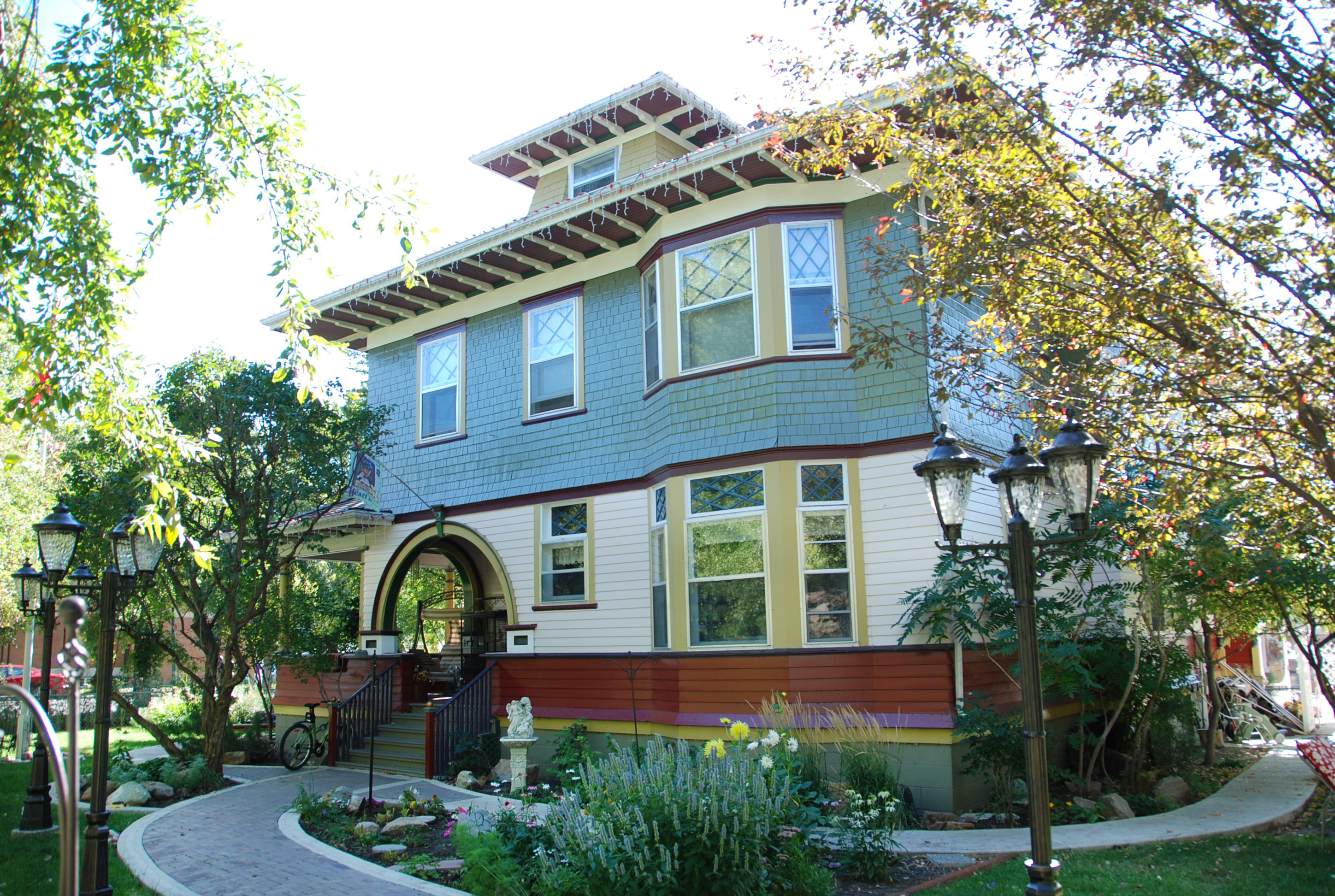
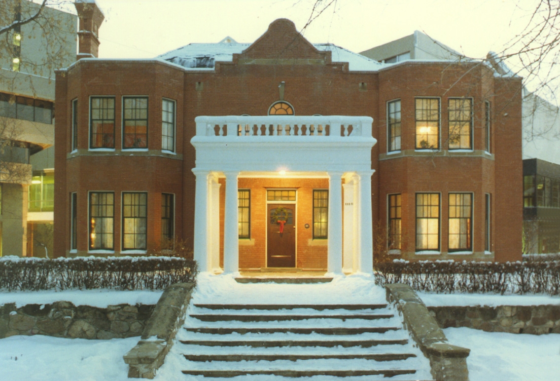
The residence known as Annandale, one of Lethbridge’s best known heritage homes, has been designated as a Provincial Historic Resource and is listed on the Alberta Register of Historic Places.
Exterior of Annandale in Lethbridge from the northwest, showing the entry porch with large arches, the wood shingle siding, bow windows and dormer window. September 2009. Alberta Culture and Tourism, Government of Alberta.
A recent Government of Alberta information bulletin announced a new Provincial Historic Resource. Check it out:
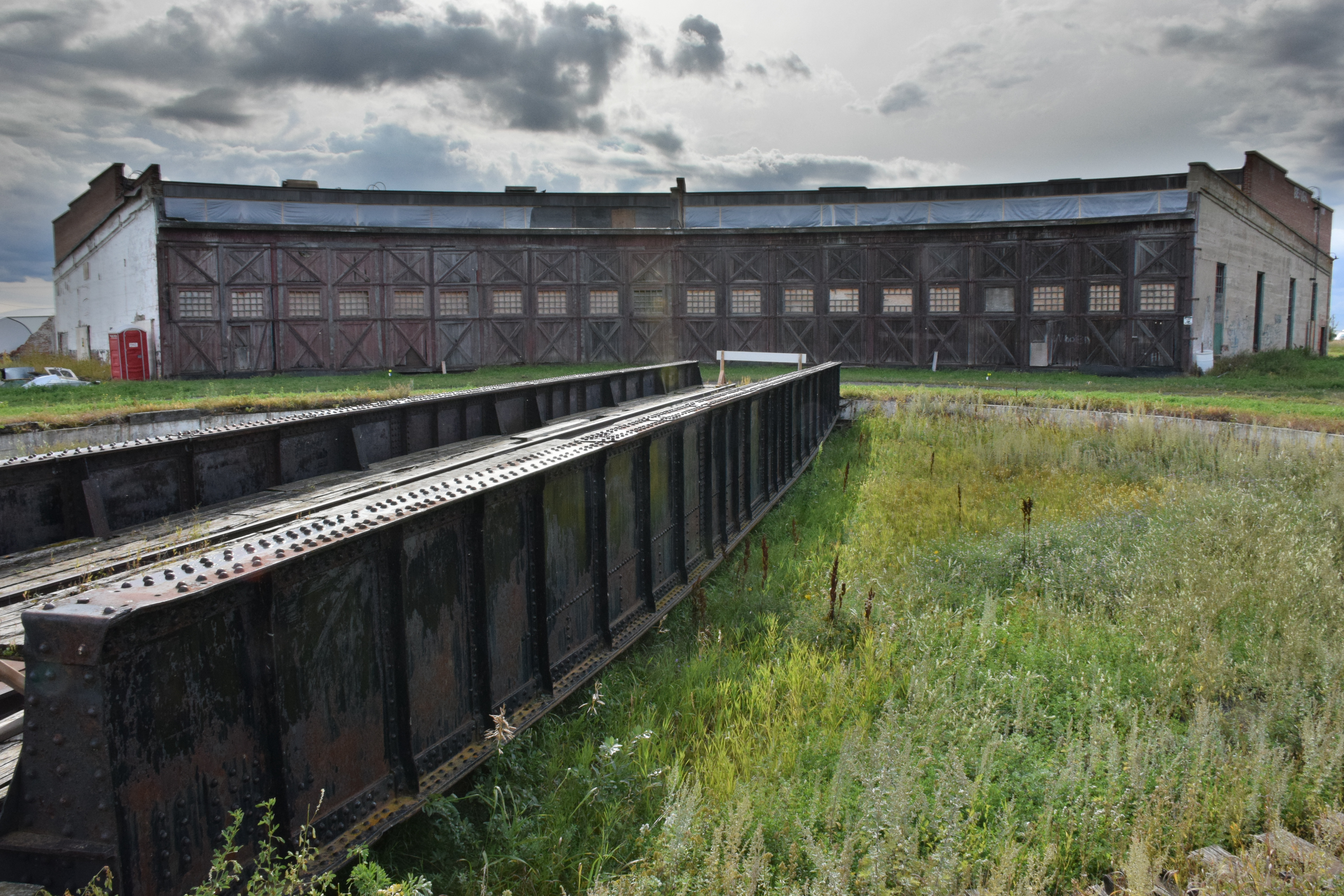
In August, 2015, a rare and important piece of Alberta’s railroading and transportation heritage has been designated as a provincial historic resource.
Exterior of the Canadian Northern Railway Roundhouse, showing the large, double doors, which provide access to the locomotive stalls. The turntable and bridge are in the foreground, September 2014. Alberta Culture and Tourism, Government of Alberta.
In 1917, surveyor and mountaineer Arthur O. Wheeler of the Interprovincial Boundary Survey wrote that “in a valley surrounded by towering peaks, lies Upper Kananaskis Lake, a large sheet of deep-blue water of irregular shape, dotted with heavily-timbered islands.” The lake, as described by Wheeler, no longer exists, its shape has changed and its islands are mostly gone.
Upper Kananaskis Lake, 1914, showing the islands (LtoR) Cressy, Pegasus, Hawke, Hogue, Schooner and Aboukir. To compare this photograph alongside a 2007 photograph, go to http://explore.mountainlegacy.ca/historic_captures/1880/comparisons. Mountain Legacy Project, WHE14-6. The Mountain Legacy Project is based at the School of Environmental Studies, University of Victoria, Victoria, BC. For more information, go to mountainlegacy.ca, or email mntnlgcy@uvic.ca.
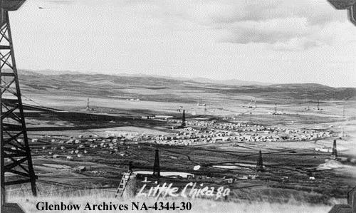
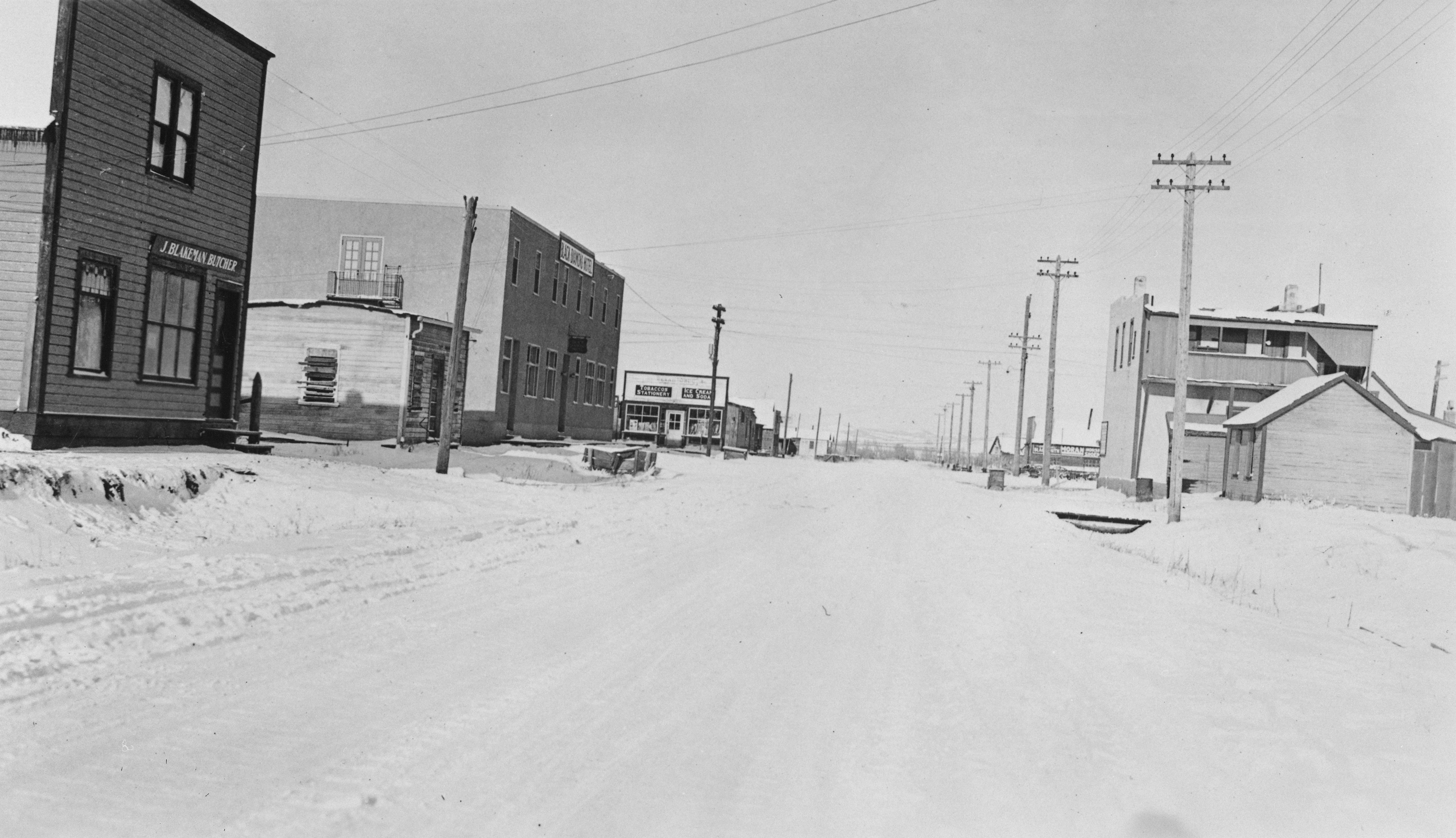
A few months back, we ran a blog post about the establishment of Alberta’s oil and gas industry at Turner Valley and the two major, and still extant, towns that developed to serve that industry – Turner Valley and Black Diamond. These two places were not the only communities that grew so suddenly and substantially with the discovery of oil in the region. In 1936, the Turner Valley Royalties Company struck oil near Longview Hill (known locally as “The Big Hill”). Oil workers again flooded to the region and numerous new communities were established. Two notable communities were given unofficial, and ironically refined, monikers – “Little Chicago” and “Little New York.”
Detail of the 1945 edition of NTS Map Sheet 82 J/09. Royalties and Longview are at the south end of the map. Although smaller than both Turner Valley and Black Diamond to the north, the two boom towns are shown as being of considerable size. Source: Department of Mines and Resources. Map 819A, Turner Valley, West of the Fifth Meridian, Alberta. Scale 1:63,360 (1 Inch to 1 Mile), 82 J/09. Ottawa: Government of Canada, 1945. Available from Natural Resources Canada. GeoGratis http://geogratis.gc.ca/geogratis/Home?lang=en.
Royalties (aka “Little Chicago”)
About 15 kilometres south of Turner Valley and Black Diamond along Highway 22 is the former community of Royalties. Little remains there today, but it was once a bustling community. Following the discovery of oil at the Turner Valley Royalties No. 1 well, a collection of shops and dwellings quickly grew nearby. In 1937, a post office opened at the town site and, due to the community’s proximity to and association with the nearby oil well, the post office and town site were given the name Royalties, but most of its residents and other locals did not use that name. Most of them called the community “Little Chicago.”
The precise origin of the name “Little Chicago” is not known, but there are a number of theories. One story is that the many American oil workers in the area ironically compared the frenetic activity of the little town site to the bustling mid-west American city. To further complement the comparison, a small slough near the town site became known as “Lake Michigan.” Another, and even more colourful origin story, concerns Rex Warman, the owner of the first store in the community. According to Rex’s wife Florence, her husband was known locally as “Little Al Capone” or “Little Scarface” due to a scar on his upper lip. Although, she also said that some people felt the store’s prices, marked high to cover transportation costs, were extortionist, which may have contributed to her husband’s Capone-esque nickname – Al “Scarface” Capone, being the legendary Chicago mob boss and rum-runner. It is an easy leap for the store location to become known as “Little Chicago.”
Little Chicago (Royalties), Alberta, 1940. Little New York (Longview) to the south and Little Chicago developed quickly after the 1936 oil strike in Turner Valley. (Glenbow Archives, NA-4344-30).
According to the local history Tales and Trails, at its height, Royalties consisted of a Hudson’s Bay store, two oil well supply depots, three trucking companies, a machine shop, three lumber yards, two garages, a furniture store, three grocery stores, many boarding houses, restaurants and a dance hall with a theatre. The boom times in Royalties did not last. As drilling tapered off, people and businesses left the community. The post office closed in 1969 and the sole remaining business, a gas station, shut down a short time later. Today, there is really nothing left on the landscape to show the existence of the community.
Longview (aka “Little New York”)
Located about 15 kilometres south of Turner Valley and Black Diamond (and four kilometres south of Royalties) is the village of Longview. Longview predates the discovery of oil and gas in the region, but the community flourished because of the oil. The name Longview came into official use when a post office of that name was opened in July 1908 in Section 25 of Township 18-2-W5. A number of possible origins for the name have been proposed. The most likely origin is that the name came about due to the location of the post office near the “Big Hill” which allowed one to see for a considerable distance, or have a “long view.” Other accounts suggest the community was named for Thomas Long, a schoolteacher who arrived in the area in 1895 and filed for a homestead on the hill.
View from the Longview Hill, November 1936. The oilfield community of Longview, or Little New York, was established near the foot of this prominent hill. (Glenbow Archives, IP-6d-3-13).
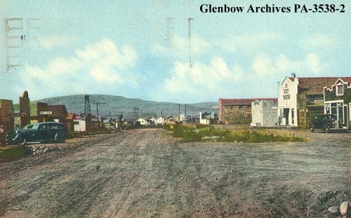
Historically, the Longview area had been associated with agriculture (ranching and farming); and today it is well known for its connections to Canadian country music (Ian Tyson shout out!). However, following the 1936 oil discovery, a boom town developed in Section 20 of Township 18-2-W5, about eight miles west of the Longview post office. Like Royalties to the north, the town site was quickly flooded with rig workers, their families and a range of associated camp followers. Mud-clogged or dust-chocked streets, depending on the weather, criss-crossed the community and inexpensive and rudimentary shacks were built practically overnight for use as houses, stores, banks and other services. The level of activity was so frantic that Longview became known, probably with a great deal of tongue-in-cheek, as “Little New York.” A local history of Longview suggests that the community’s residents did not want to be upstaged by “Little Chicago” up the road and did them one better by adopting the larger American city as their unofficial namesake.
Longview, Alberta 1940-1945. The community was known as “Little New York” following a 1936 oil discovery in Turner Valley. It was likely a sarcastic reference to the frantic pace of development at the town site. (Glenbow Archives, PA-3538-2).
In 1937, the Longview post office moved from the hill to the town site and the community became Longview, although it continued to be referred to as “Little New York” for many years. Towards the end of the 1940s, oil boom growth had settled and with it, so did the pace of development in the area. Unlike Royalties, which essentially disappeared, Longview continued to exist as a rather sedate little hamlet. On January 1, 1964, Longview, with a population of 206 was officially made a village.
Through history, many resource communities have been given ironic, unusual and occasionally ribald names. Often these names are not the ones that end up being approved by naming authorities for use on official maps. For many of these communities and places, such as Longview and Royalties, the unofficial names continue to be used by those most familiar with the place and its history. The culture and history of a place can be read through the names on its maps, but sometimes, the names not on the maps can tell us much more.
Written by: Ron Kelland, Historic Places Research Officer and Geographical Names Program Coordinator.
Sources and Additional Resources:
In the Light of the Flares: History of Turner Valley Oilfields, (Turner Valley: Sheep River Historical Society, 1979).
Tales and Trails: A History of Longview and Surrounding Area, (Longview: Tales and Trails History Book Society, 1973).
May 14, 2014 was the one-hundredth anniversary of the discovery of oil and gas at Turner Valley. In recognition of this milestone, we are offering a short series highlighting some of the place names associated with the oil and gas heritage of the Turner Valley area.
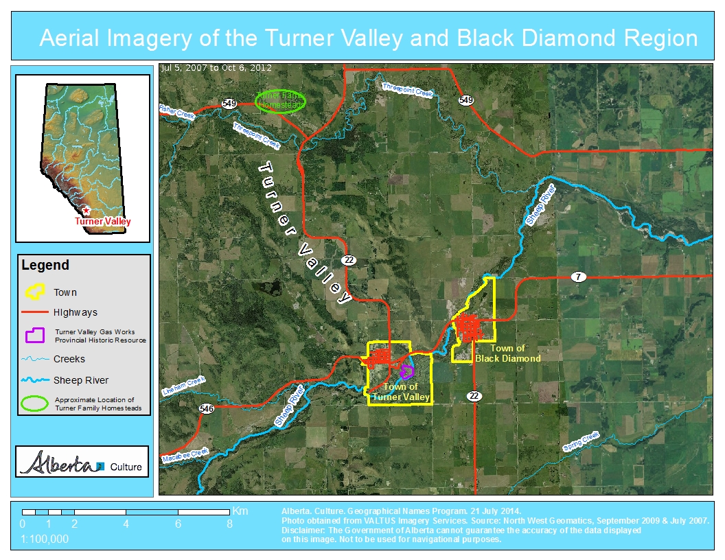
Turner Valley
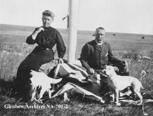
In 1886, two brothers from Scotland, Robert and James Turner, filed for homestead on neighbouring quarter sections (the S.E. and S.W. quarters of Section 10, Township 21, Range 3, West of the Fifth Meridian) at the northern end of a large valley near the north fork of “Sheep Creek.” (To add a heaping helping of confusion to this story, what was then called Sheep Creek is now the Sheep River and its north fork, or tributary, is now named Threepoint Creek. Isn’t naming fun!) The Turner brothers, soon joined by a cousin, John Turner, acquired more land for their ranch and became noted breeders of purebred Clydesdale horses.
Due to the early arrival and prominence of the Turner family, the valley containing their original homesteads soon became known as Turner Valley. At the time, responsibility for naming geographical features lay with the federal government and the name Turner Valley was adopted by the Geographic Board of Canada as the valley’s official name in December 1943, although it was being used on government maps since at least 1926.
Photo of Catherine (née Dawson) and Robert Turner, ca. 1905, taken on the Turner ranch at the northern end of Turner Valley. (Glenbow Archives, NA-701-2.)
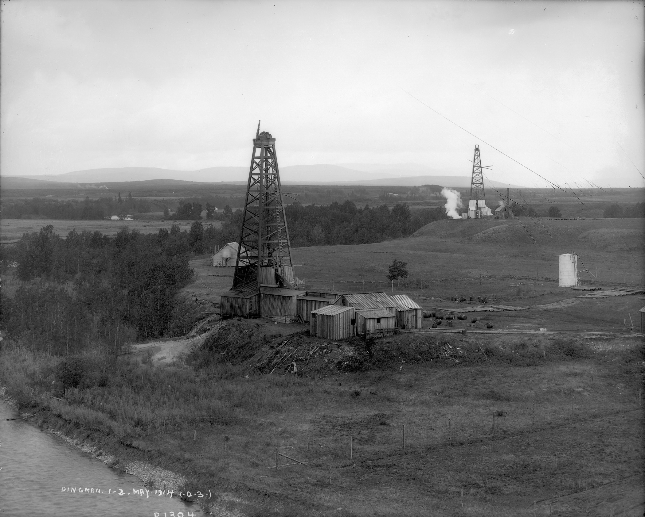
On May 14, 1914, towards the other end of the valley, an oil well known as Dingman No. 1, owned by Calgary Petroleum Products struck gas. Although DIngman No. 1 was not the first productive well in Alberta—that distinction goes to a well in Waterton Lakes National Park (See Cameron Creek) it was our province’s the first significant discovery.
The Dingman No. 1 and Dingman No. 2 wells on the banks of the Sheep River, Turner Valley, 1914. These two wells ushered in Alberta’s first major oil boom, which saw the drilling of hundreds of wells and the establishment of numerous communities in the Turner Valley region. (Provincial Archives of Alberta, P1304.)
Over the ensuing decades the name Turner Valley became one of the best known locales in the province and the name became synonymous with Alberta’s oil and gas sector. A town site, also named Turner Valley was established. A post office opened here in 1926 and, in 1930, with a population of about 700 people, Turner Valley was incorporated as a village. It became a town in 1977.
Black Diamond
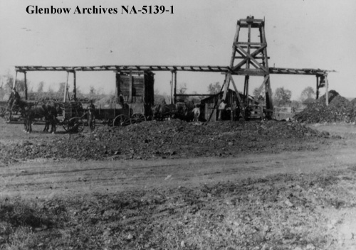
Just to the east of the Town of Turner Valley, is the Town of Black Diamond. The name is inspired by the coal deposits found in the area. A coal mine opened in 1899 and a small community serving the mine and the area’s ranchers and homesteaders began to develop.
According to local lore, in 1907, when it came time to choose a name for the newly established post office, two contenders arose: “Arnoldville” was championed by the Arnold brothers who owned the general store that would house the post office, and “Black Diamond” was put forward by Addison McPherson, the owner and operator of the Black Diamond Coal Mine a short distance to the southwest. Allegedly, both were written on scraps of paper and put into a hat. You can guess which name was drawn.
Addison McPherson’s “Black Diamond” coal mine, ca. 1913-1916. The local post office and the community it served were named for this coal mine. (Glenbow Archives, NA-5139-1.)
Following the Dingman No. 1 discovery, Black Diamond boomed, reaching a reported population of 800 by 1930. A local history tells of round-the-clock construction and single lots containing up to seven homes. Black Diamond became a village in 1929. It suffered during the Great Depression, loosing up to a quarter of its official population before rebounding in 1937 following a major oil discovery in 1936. Black Diamond was the largest population centre in the immediate area, reaching a population of 1,380 in 1947 before falling again through the late-1940s and 1950s. Regardless, in 1956, with a population of 991, Black Diamond was incorporated as a town.
Commercial district of Black Diamond, January 1932. Although it Pre-existed the Turner Valley oil and gas discovery, Black Diamond grew rapidly to serve the burgeoning industry. (Provincial Archives of Alberta , A6999.)
To be continued … More Turner Valley oil and gas names to come!
Written by: Ron Kelland, Historic Places Research Officer and Geographical Names Program Coordinator.
Location
Turner Valley (valley)
National Topographic System Map Sheet: 82 J/09 – Turner Valley
Latitude/Longitude: 50°42’33”N / 114°18’11”W (approximate mid-point)
Alberta Township System: 23-20-3-W5 (approximate mid-point)
Description: Large valley with a northwest to southeast orientation, located approximately 40 kilometres southwest of downtown Calgary
Turner Valley (town)
National Topographic System Map Sheet: 82 J/09 – Turner Valley
Latitude/Longitude: 50°44’31”N / 114°16’49”W
Alberta Township System: 12-20-3-W5
Description: Near the southeastern edge of the valley, approximately 45 kilometres SSW of downtown Calgary
Black Diamond (town)
National Topographic System Map Sheet: 82 J/09 – Turner Valley
Latitude/Longitude: 50°41’17”N / 114°14’04”W
Alberta Township System: 8-20-2-W5
Description: Approximately 40 kilometres SSW of downtown Calgary and three kilometres northeast of Turner Valley (town)
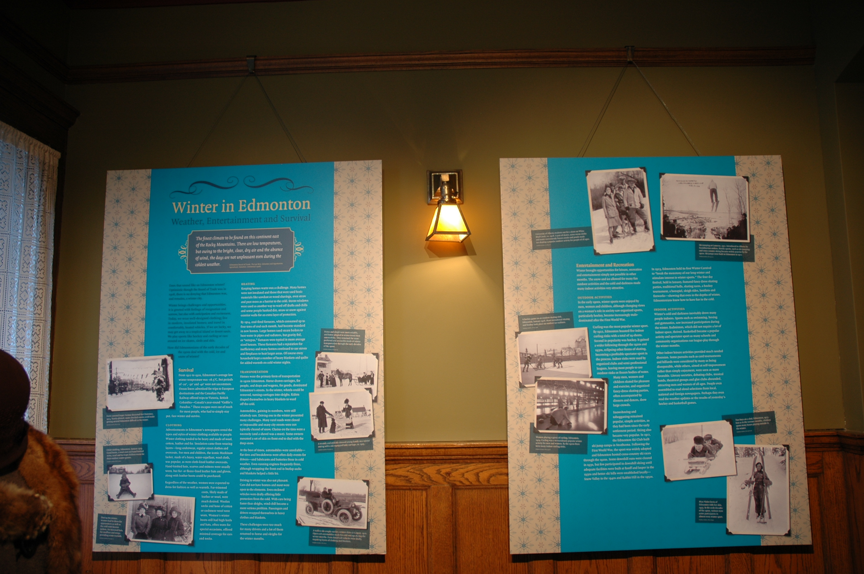
The Rutherford House Historic Site and Museum Christmas season exhibit is now on display. This year the exhibit is Winter in Edmonton – Weather, Entertainment and Survival. The exhibit runs from December 2013 until January 24, 2014.
Rutherford House Historic Site and Museum in winter (2005).
Edmonton is a winter city. That undeniable fact was clearly demonstrated a few weeks ago when the thermometer dropped to -30°C. On cold and snowy days many of us stay inside our centrally-heated homes and shudder as we look out over wind-swept, icy and snow-covered streets and sidewalks.
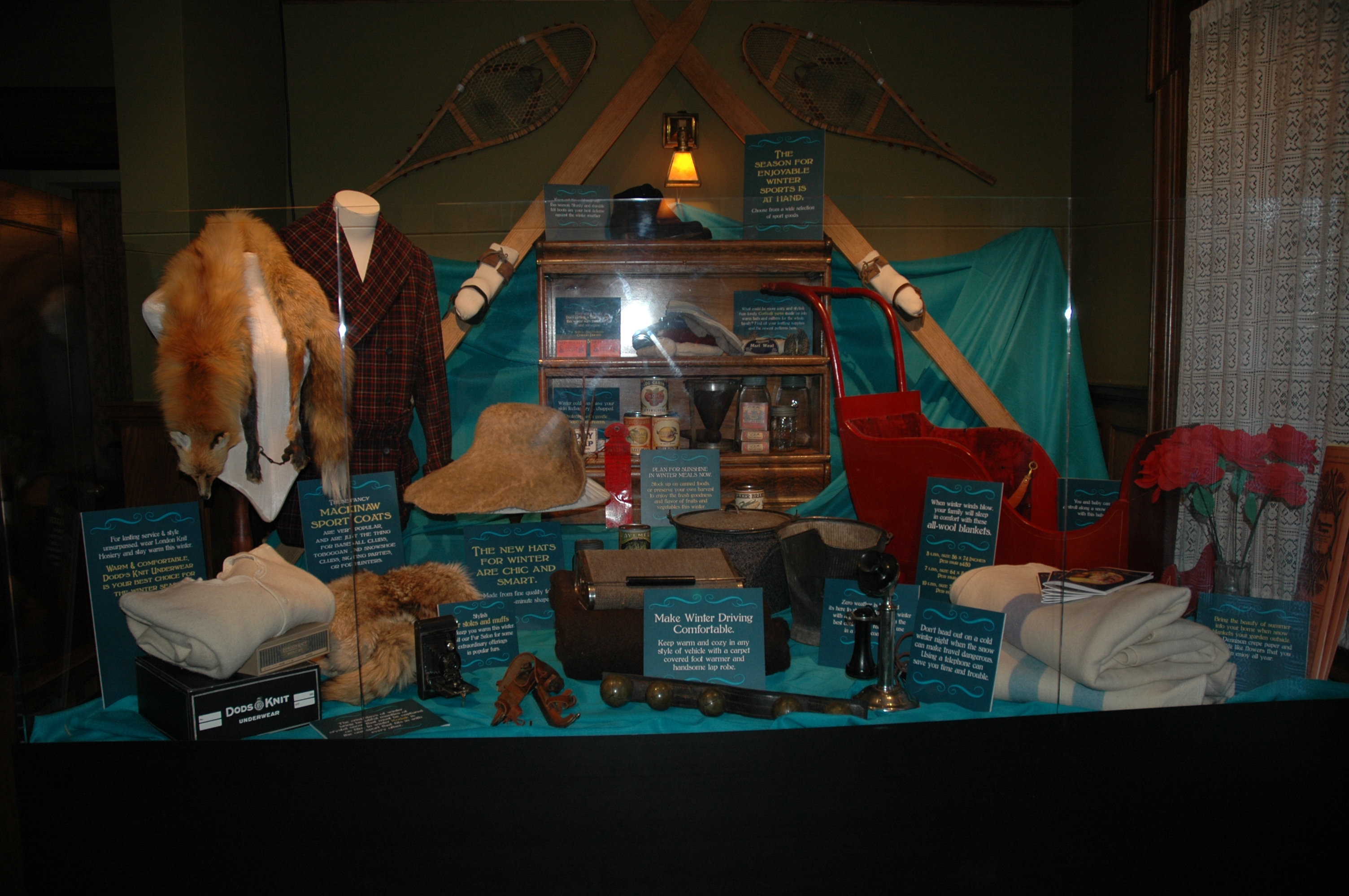
A selection of winter-related artifacts from the Rutherford House collection and the Royal Alberta Museum are on display at the Rutherford House Historic Site and Museum until January 24, 2014.
Winter is not all cold and dreariness, of course. Winter is a season of fun and outdoor games. It is a season of snowmen and skating parties, of shinny and skiing. It is a season of companionship amongst friends and family, of hot chocolate and large meals.
Whether you enjoy bracing walks outside or a book by a warm fire inside, have you ever wondered how did Edmontonians of the 1910s to the 1930s deal with winter? How did they keep warm outside? How did they heat their homes? How did they get around their community? What did they do for fun in the snow? What did they do when it was too cold to go outside?
Interpretive panels and archival photographs explain and illustrate how Edmontonians survived and enjoyed winter in the 1920s and 1930s.
Visit the Winter in Edmonton exhibit at the Rutherford House Historic Site and Museum for the answers to these questions and to learn about this Provincial Historic Resource – one of Edmonton’s early architectural gems and the historic family home of Alberta’s first Premier.
The Rutherford House Historic Site and Museum is located on the University of Alberta campus at 11153 Saskatchewan Drive. Winter hours are 12 (noon) until 5:00pm, Tuesday through Sunday. While you are there, stop and visit the newly re-opened gift shop for great Christmas stocking stuffers.
Written by: Ron Kelland, Historic Places Research Officer and Geographical Names Program Coordinator.
Most people understand the importance of the oil discovered at Leduc in 1947 and the oil and gas discovered in Turner Valley in 1914. However, Alberta’s oil and gas industry began in 1901 with an isolated oil well alongside a creek near the Canada-United States border.
That creek was known as Oil Creek. Now known as Cameron Creek, this 15 kilometre long creek runs north-easterly for about 9 kilometres before turning and flowing south-easterly into Upper Waterton Lake. The source of the creek is Cameron Lake, a small lake on the Canada-U.S. border deep within Waterton Lakes National Park. The lake was once known as Oil Lake. (Do you see a pattern?)
Aerial Imagery of Waterton Lakes National Park, showing the locations of the Cameron Lake (formerly Oil Lake) Cameron Creek (formerly Oil Creek) and the First Oil Well in Western Canada National Historic Site of Canada.
The lake and the creek were noted, but not named, on George Dawson’s 1884 map of the Bow and Belly River region of the North-West Territories. During his surveys of the area in the 1880s (with the Geological Survey of Canada) and earlier (with the International Boundary Commission) in the 1870s, Dawson was made aware of oil and gas in the Waterton region. In 1901, the Rocky Mountain Development Company drilled Western Canada’s first oil well alongside a creek, which soon became known, for obvious reasons, as Oil Creek.
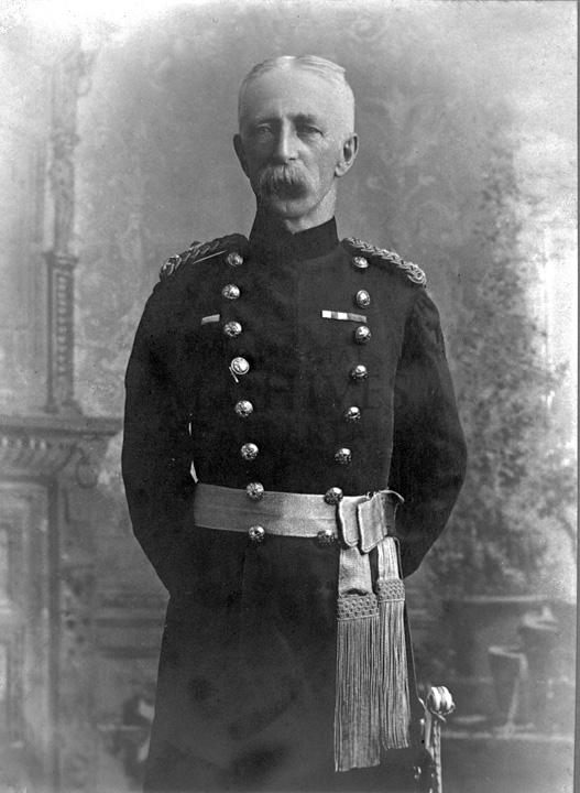
In 1915, during the survey of the Alberta-British Columbia border, the lake and creek were again noted. The 1917 report on the Alberta- B.C. boundary described them as: “Cameron Lake, a picturesque sheet of water, one mile and a half long by half a mile wide” and “Cameron Brook, a stream of considerable size, which flows to Upper Waterton Lake”.
The lake and creek were named for Maj.-Gen. Donald Roderick Cameron, a Scottish-born Royal Artillery officer and son-in-law to Sir Charles Tupper. Prime Minister John A. Macdonald recommended Cameron’s appointment as the British Boundary Commissioner and head of the British-Canadian delegation to the International Boundary Commission. From 1872-76, Cameron oversaw the surveying of the Canada-U.S. border between the Lake of the Woods (in western Ontario) to the Rocky Mountains. He later represented Canada on numerous international commissions and conferences through the 1880s and he served as commandant of the Royal Military College in Kingston, Ontario from 1888 to 1896. For his services to the boundary commission he was appointed to the Order of St. Michael and St. George by Queen Victoria. General Cameron died in 1921. In 1943, Cameron Falls, just north of the Waterton Park town site, was also named in his honour.
Capt. Donald R. Cameron, head of the British-Canadian contingent of the International Boundary Survey, in 1872.
In 1915, the Geographic Board of Canada adopted Cameron Brook as the official name for the creek. Although, the name of the lake was not officially changed at the time, it nevertheless began appearing on federal government maps as Cameron Lake. The name Cameron Lake was officially adopted in 1928. The following year, the United States Board on Geographic Names adopted the same name for the portion of the lake located in Montana. In 1960, the Canadian Board on Geographical Names renamed Cameron Brook as Cameron Creek.
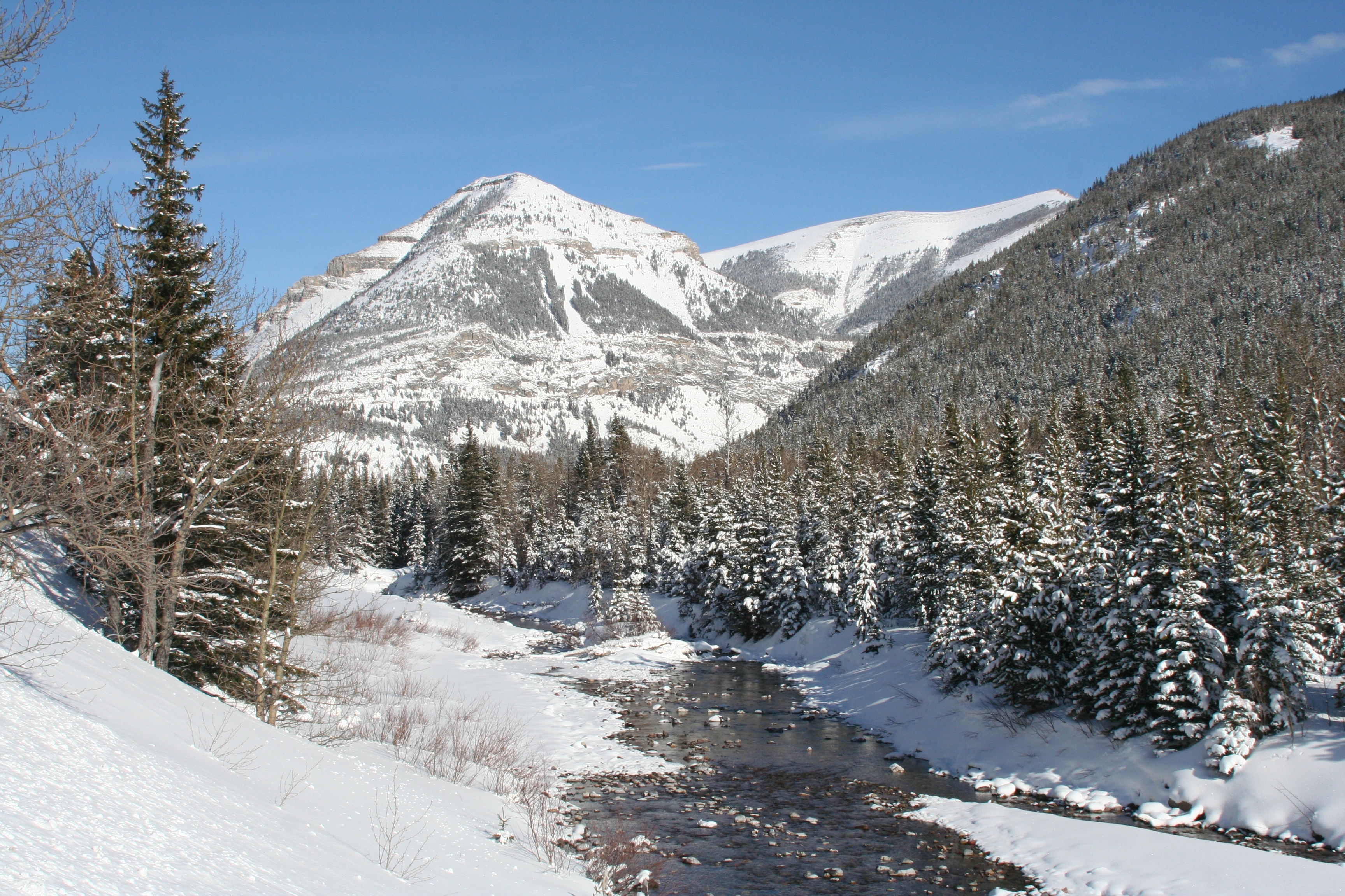
Cameron Creek, formerly known as Oil Creek, flows through the rugged terrain of Waterton Lakes National Park. Western Canada’s first oil well was located alongside this creek.
Although the names Oil Lake and Oil Creek are no longer official, the significance of the area in the development of Canada’s oil sector is commemorated by the Historic Sites and Monuments Board of Canada. In 1965, a monument was erected at the site the original oil well and the site was named the First Oil Well in Western Canada National Historic Site of Canada.
Written by: Ron Kelland, Historic Places Research Officer and Geographical Names Program Coordinator.
Location
Cameron Creek
National Topographic System Map Sheet: 82 H/04 – Waterton Lakes
Latitude/Longitude: 49°01’11N / 114°02’38”W to 49°02’41”N / 113°54’45”W
Alberta Township System: SW11-01-01-W5 to NW14-01-30-W4
Description: Flows into Upper Waterton Lake within the Waterton Park town site.
Cameron Lake
National Topographic System Map Sheet: 82 G/01 – Sage Creek
Alberta Township System: 2, 3, 10, 11-01-01-W5
Description: On the Canada/US border approximately 11 km south west of the Waterton Park town site and 1 km east of the Alberta/British Columbia boundary.
Additional Resources
More information about Cameron Creek, Cameron Lake, Maj-Gen. Donald R. Cameron and the First Oil Well in Western Canada can be found in:
Edwards, Victoria. “Major General Donald Roderick Cameron C.M.G.” eVeritas [electronic newsletter of the Royal Military College Club], available from http://everitas.rmcclub.ca/?p=4485. (Accessed 16 Oct 2013).
Rees, Tony. Arc of the Medicine Line: mapping the World’s Longest Undefended Border across the Western Plains. Lincoln, NB: University of Nebraska Press, 2007.
Last Sunday (June 2nd) was the 60th anniversary of Queen Elizabeth II’s coronation. She had been Queen for over a year at the time. (She ascended to the throne upon the death of King George VI, her father, in February 1952.) The timing allowed for a period of mourning for the late King and to organise the pomp and ceremony of a coronation.
Canada marked the occasion by naming a large mountain range in Jasper National Park for our new Queen. Many places names in Canada have been inspired by members of the Royal family. To learn more about this you could revisit our post on the Royal Jubilee, Queen Elizabeth II and Place Names.
Written by: Ron Kelland, Historic Places Research Officer and Geographical Names Program Coordinator.
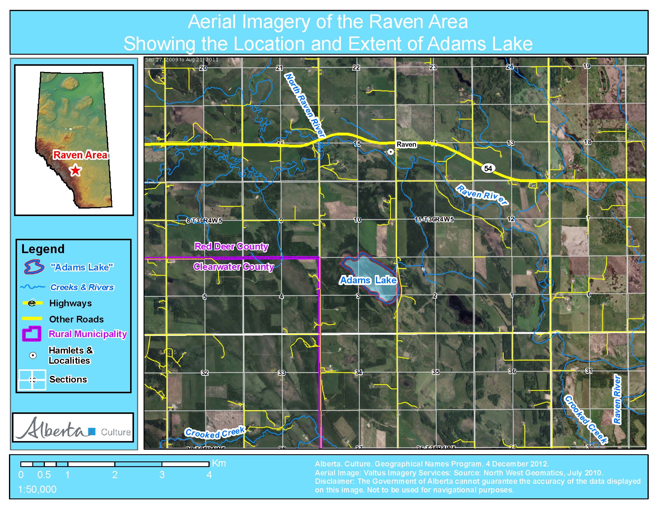
Adams Lake (looking west), August 29, 2012, Alberta Geographical Names Program
The Alberta Historical Resources Foundation and the Minister of Culture has officially adopted the name Adams Lake for a small lake in Red Deer County (see information bulletin). The lake is approximately 100 hectares (250 acres) in size and located about two kilometres south of Raven and 35 kilometres west of Innisfail. The adoption of this name is significant as it commemorates the Adams family, who homesteaded in the region, and recognizes a name that has been used locally for about 100 years.
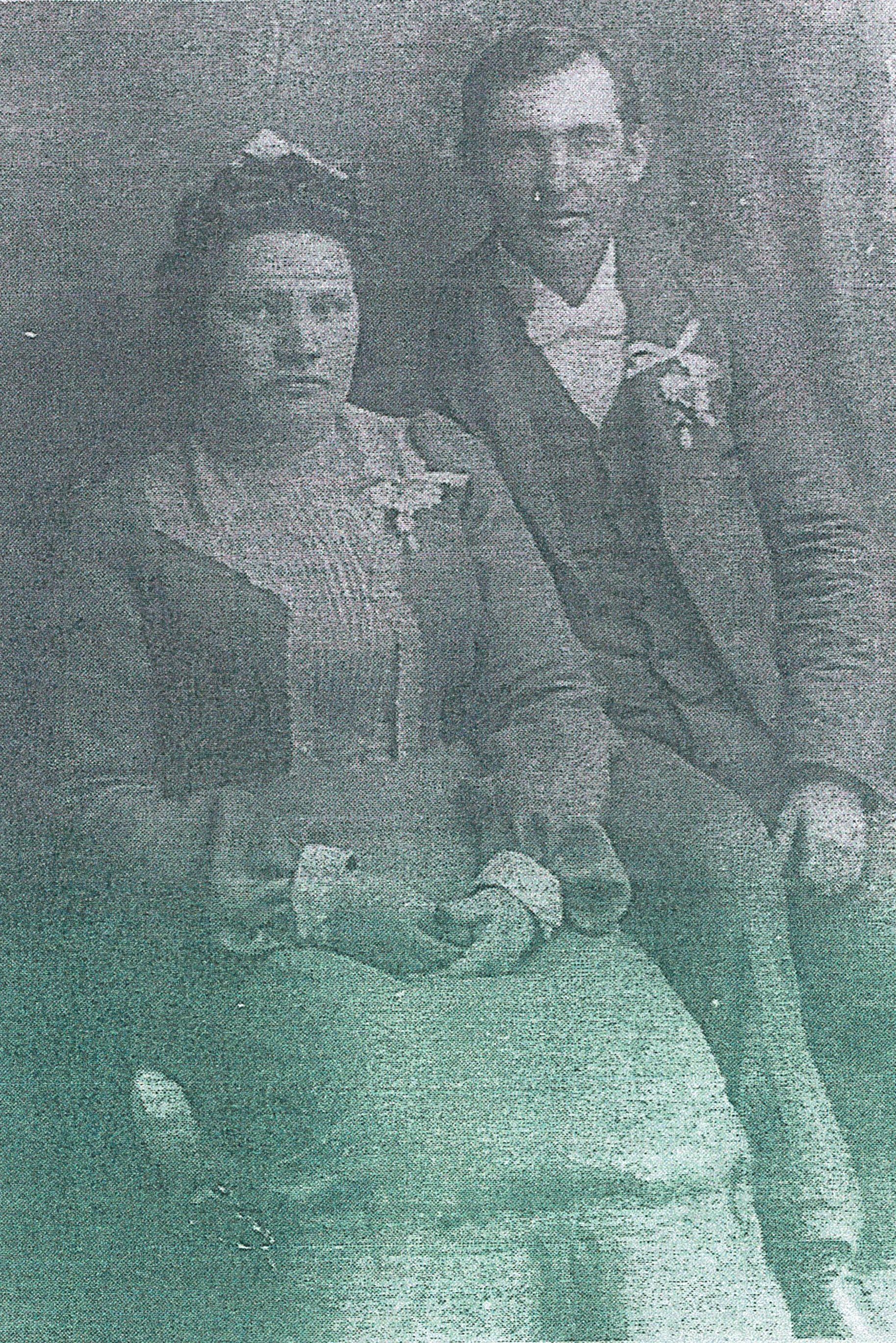
David Arthur and Julia Marie Adams, 1902, Photograph courtesy of the Adams family
The name commemorates the family of David and Julia Adams. David Arthur Adams was born in Stratford, Ontario. As a young man he met Julia Marie Hedlund, of Chippewa County, Minnesota at a hotel in Lakota, North Dakota. They were married in 1902 and lived for a time with David’s parents in Birtle, Manitoba. The couple soon struck out on their own and lived for a time in Vancouver and Mission, British Columbia and in Calgary, Alberta. Ultimately, in 1912, they settled on a homestead in the Raven District. The homestead, NW2-36-4-W5, was on the eastern shore of a small lake. The lake had been previously noted as “Lake No. 3” in a 1904 Dominion Land Survey Plan of Township 36-4-W5 and it appears unnamed on most federal government maps of the region following that date. It became popular with people from as far away as Spruce View for skating in the winter months and after 1912, it became known to locals as “Adams Lake,” likely due to the family’s proximity.
By the time the Adams’ had settled near Raven, they were raising six children, and four more were born during their time at the homestead. According to David and Julia’s descendents, the land the family was working was not ideal for agriculture and, perhaps for this reason, at the age of 42, David Adams enlisted for service with the 187th (Central Alberta) Regiment during the First World War. Following the war he returned to farming. However, as the older children grew up and left home for farms in the neighbouring districts, and other careers of their own in Spruce View, Bowden, Innisfail and Rocky Mountain House, the farmstead was not sustainable and at some point in the 1920s David and Julia also left the area. David passed away in Calgary in 1942. Julia lived with her children in the Dickson and Kevisville districts and the Pigeon Lake area before also passing away in Calgary in 1966.
Although the Adams family remained in the general area for some time, their direct association with the lake was relatively short. However, field research done by the Alberta Geographical Names Program in 1981 and 2012 found that the name Adams Lake was still being used by many local residents and that the name had been in use since at least the 1920s, probably even longer. The lake has also been identified by that name in local publications, newspapers and water conservation reports for the area.
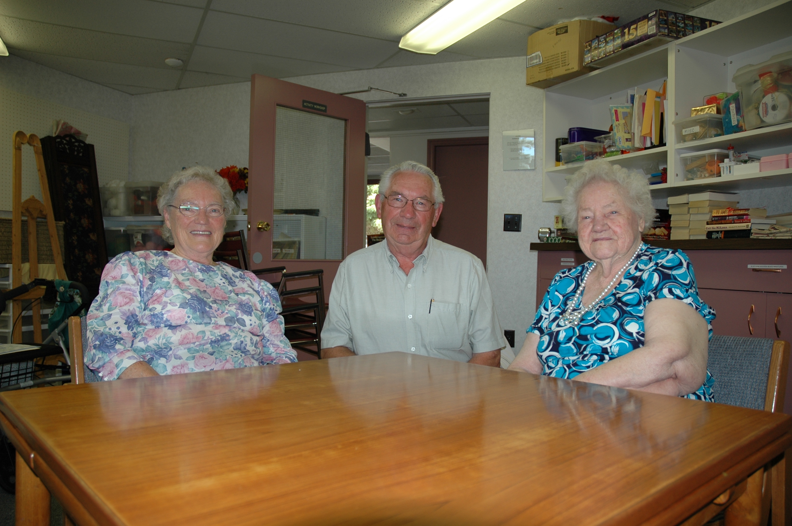
In Alberta, geographical names are adopted after being evaluated against the “Principles of Geographical Naming.” These principles can be found in the Geographical Names Manual.The principles to approve names are based on national and international standards and guidelines and hold that names that have a demonstrated local and/or historical usage should be given primacy when names are being considered for features with no official name. In 2011, Robert Nanninga, a resident of the Raven area applied to Alberta Culture to have the long-standing, but unofficial name given official recognition by Alberta Culture. A considerable amount of information was provided by the applicant and the region’s local history (Grub Axe to Grain…). However, the real breakthrough came when another area resident put researchers in touch with Ken Adams, a grandson of David and Julia. Through him connections were made with Georgina O’Coin, a granddaughter, and Edith Hudson (née Adams), the last surviving child of David and Julia. When these three family members were interviewed in Red Deer in August 2012, Mrs. Hudson was 101 years old. The information given during this interview proved invaluable in firming up the history of the lake and family by providing more details than were included in the local history. It was a true pleasure to be able to meet with the descendents of this homesteading family.
LtoR: Georgina O’Coin, Ken Adams, Edith Hudson (née Adams). Taken at Red Deer, August 29, 2012, Alberta Geographical Names Program
The Adams Lake naming proposal was supported by the Municipal Council of Red Deer County. The Board of the Alberta Historical Resources Foundation decided to officially adopt the name during their October 20, 2012 meeting in Banff. On November 19, 2012, the Minister of Culture concurred with the board’s decision and the adoption of the name became official. Notification of the adoption of the name Adams Lake was published in Alberta Gazette on January 15, 2013. Notification of the new official name has been communicated to provincial mapping authorities and to the Secretariat of the Geographical Names Board of Canada for inclusion in the Canadian Geographical Names Database, ensuring that the name will appear on new maps of the region produced by the federal and provincial governments.
Written by: Ron Kelland, Historic Places Research Officer and Geographical Names Program Coordinator
Location
National Topographic System Map Sheet: 83 B/1 – Markerville
Latitude/Longitude: 52° 04′ 05″ N & 114° 29′ 05″ W
Alberta Township System: Sec. 3 Twp. 36 Rge. 4 W5
Description: Approximately two km south of Raven and 35 km west of Innisfail (town).
Additional Resources
Additional information about the lake and the Adams family can be found in:
Grub Axe to Grain…: A History of Craig, Dickson, Happy Hill, Heckla, Hola, Markerville, New Hill, North Raven, Raven, Red Raven, Rich Hill, Spruce View (Spruce View: Spruce View School Area Historical Society, 1973).Available from Our Future Our Past: The Alberta Heritage Digitization Project, University of Calgary, http://www.ourfutureourpast.ca/loc_hist/toc.aspx?id=7618.