The Historic Resources Management Branch of Alberta Culture works with Aboriginal communities to help preserve and protect their cultural heritage sites. Alberta Culture also recognizes the benefit of working collaboratively with Aboriginal communities on the promotion and interpretation of Aboriginal cultural heritage and welcomes inquiries from communities who would like assistance in this regard.
June 21 is National Aboriginal Day, a day for all Canadians to celebrate the cultures and contributions to Canada of First Nations, Metis and Inuit peoples. The history of National Aboriginal Day harkens back to 1982 when the National Indian Brotherhood (now the Assembly of First Nations) called for the creation of National Aboriginal Solidarity Day to be celebrated on June 21. Thirteen years later in 1995, the Royal Commission on Aboriginal Peoples recommended that a National First Peoples Day be designated. National Aboriginal Day is now part of a series of Celebrate Canada days, beginning with National Aboriginal Day and followed by the National Holiday of Quebec on June 24, Canadian Multiculturalism Day on June 27, and concluding with Canada Day on July 1.
The word ‘Okotoks’ translates from the Blackfoot language as ‘Big Rock.’ The name was given by the resident indigenous people to a very large boulder that is known as a glacial erratic – boulders that have been moved from their original location by glacial ice. Okotoks is by far the largest erratic in Alberta; it is about the size of a two-story house and is estimated to weigh nearly seven million kilograms. The Big Rock is a well-known landmark in southern Alberta. It is a designated provincial historic resource owned by the Government of Alberta, and is accessible to the public by means of a hiking trail, signage and a parking lot. What is not well-known is that the Okotoks Big Rock has a great deal of Aboriginal rock art painted on its surfaces.
Okotoks Big Rock Erratic
Rock art includes pictographs (paintings) made with a red paint composed of iron-rich hematite (red ochre). The existence of a few red ochre images on the Big Rock has been known for decades, but the revolution in digital photography and image enhancement has brought to light a whole lot more art on the Okotoks erratic than previously known. Specifically, we now know that some areas of the rocks were extensively rubbed with red ochre. Since these red areas lack definable rock art figures like humans and animals, it was long believed that the red blotches were simply part of the rocks’ natural colour. Through enhancement we can now pick out hand prints and finger swipes, telling us these red blotches were indeed made by human beings.
Rock art at Okotoks Big RockPhoto-enhanced areas of red ochre smeared on Okotoks Erratic. Note hand prints at top.
All rock art sites are sacred to Native people; rock art represents communication between human beings and the spirit world. Blackfoot people still visit the Okotoks site, conduct ceremonies, and hold the site in great reverence. Thus, it is all the more sad and frustrating that the Okotoks erratic has been subjected to extensive and increasingly frequent bouts of vandalism. As the site is operated by the province and is open to the public, there comes a point where some action needs to be taken. It is an eyesore, an embarrassment and severely disrespectful to the Blackfoot beliefs about the sacred character of the rock. But what can be done with a massive rock surface covered with graffiti that underneath lies fragile, precious painted pictures that tell stories of ancient Aboriginal people?
In the past few years, serious incidences of graffiti were washed off the rock face using a high pressure water sprayer. More recently, an environmentally friendly paint stripper had been used with good success. But critical to any graffiti removal has been potential impact to underlying rock art. We realized that we could never properly manage the site until we had a high-quality “map” of the rocks that plots the complex rock structure and the locations of all the rock art images. We realized that the best way to make a physical record of the Big Rock was to record it in 3D using a portable laser scanner. While documentation won’t stop vandalism at Okotoks, it will make us much better prepared to deal with future instances in a way that protects significant historical resources.
This slideshow requires JavaScript.
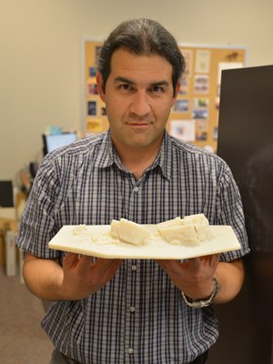
A partnership with the internationally respected organization CyArk was formed. CyArk is a nonprofit organization dedicated to digital recording and preservation of the world’s most significant sites. Among their credits are 3D recordings of the statues of Easter Island, Pompeii, ancient Thebes, and Mt. Rushmore. CyArk also digitally stores the 3D information for each site, serving as a world archive of heritage data. CyArk retained a local service provider to assist with the equipment and expertise to conduct the laser scanning. In early October 2013 the entire external surface of the Okotoks Big Rock, including the tops of the rocks and some internal crevices, was scanned during two days of field work. The result is a strikingly accurate rendering of the Okotoks erratic in both its geometric shape and the plotting of all known rock art images. The project also resulted in production of an accurate 1:200 scale model of the Rock that will be useful for planning and educational purposes.
3D rendering of point cloud data from laser scan at Okotoks with enhanced photography overlaid. Red areas are red ochre paint; note square-bodied human figure at upper left.
In addition to the rendering and scale model, the project also raised awareness about negative impacts associated with graffiti and heightening understanding of the value and importance of historic resources to the community. Further Alberta Culture now has a sophisticated tool to use for site management.
Alireza Farrokhi holding 1:200 scale model of the Big Rock
Sadly, the rocks have already been subjected to more graffiti in the months since our project ended; however, we now have accurate information on the type and location of rock art that will assist in graffiti removal efforts. There are other threats to the cultural and natural significance of the Okotoks erratic. It has long been a favoured place for climbers, subdivisions are rapidly encroaching on the site, and public visitation is increasing. There are many challenges ahead in the long-term management of the Big Rock, but thanks to the careful recording conducted through Innovation Program funding we have a solid baseline of information about this very special place that will guide future management.
Written by: Jack Brink, Curator, Royal Alberta Museum and Alireza Farrokhi, Head of Conservation and Construction Services, Historic Places Stewardship
The National Main Streets Conference is a big event. This year over 1,400 people attended the conference and there were approximately 75 sessions to choose from. Needless to say it was difficult to choose which sessions to attend. Of the sessions that I attended two stood out for me as being really helpful for our Main Street members: “The Naked Truth about Well-Dressed Windows” and “Main Street Makeover – Surviving and Thriving during Construction”.
Storefront Windows
Store owners only have a few seconds to convince a passerby to enter their establishment. The quality and interest of store window displays goes a long way in enticing potential shoppers. “The Naked Truth about Well-Dressed Windows” provided by Seanette Corkill of Frontdoor Back, a retail consultant based out of Vancouver, Washington, included a lot of practical advice on how to plan for and manage your window displays.
Seanette covered planning and investment for window dressings and stressed the importance of budgeting for lighting and props to build a collection that can be used over time. The decision on what type of backdrop to use is important and you can choose from full disclosure (store is visible behind the display), partial disclosure (where the store is partially visible but separated from the display) and closed (display blocked from the rest of the store). Decals are a good addition to storefront but they should be modest in size, not interrupt sightlines and placed to direct the eye to the display itself. Lighting is immensely important and should consist of tracked lighting that will light the top and front of the product on display.
Switching topics from the pretty to the dirty, Kristi Trevarrow’s session on “Surviving and Thriving during Construction” drew on her role with the Rochester Downtown Development Authority in coordinating a main street upgrade project in Rochester, Michigan. The project involved a complete overhaul of the roads, underground services and streetscape and affected their downtown main street for several months. Her responsibility was to minimize the impact of the construction project on local businesses.
According to Kristi, the key to managing business during a successful construction project is pre-planning and communication. In her case, Kristi started holding information meetings two years in advance of the construction and met with everyone she could think of including business owners, residents, local organizations, major employers, property owners and adjacent municipalities. Communications for the project included a project website with regular updates; a brochure with frequently asked questions for businesses to hand out to their patrons; a comprehensive media engagement strategy; social media updates; a field office on the main street for the project (which they built into the project contract); monthly community meetings throughout the duration of the project; and last but not least, a presence on the street every day during construction to field questions and respond to concerns. There were still hiccups that occurred along the way but the high level of planning and engagement by the Development Authority minimized negative experiences.
Both high quality window displays and infrastructure renewal projects can go a long way to ensuring your main street is looking top notch. These sessions were helpful in teaching the ins and outs of how to schedule and manage aesthetic projects from the small to large.
Written by: Rebecca Goodenough, Municipal Heritage Services Officer
The Bow On Tong Building and the Manie Opera Society Building are two well-known places in downtown Lethbridge that contribute to the distinctive cluster of buildings that make up Lethbridge’s Chinatown district. Recognizing their remarkable history and exceptional significance, the City of Lethbridge’s council recently designated each as a Municipal Historic Resource. The buildings are now undergoing comprehensive rehabilitation, including extensive structural repairs and the careful retention of historic elements found nowhere else in Alberta. I had the opportunity to visit these fascinating places just before Easter, gaining a glimpse into Lethbridge’s Chinese community during the first half of the last century.
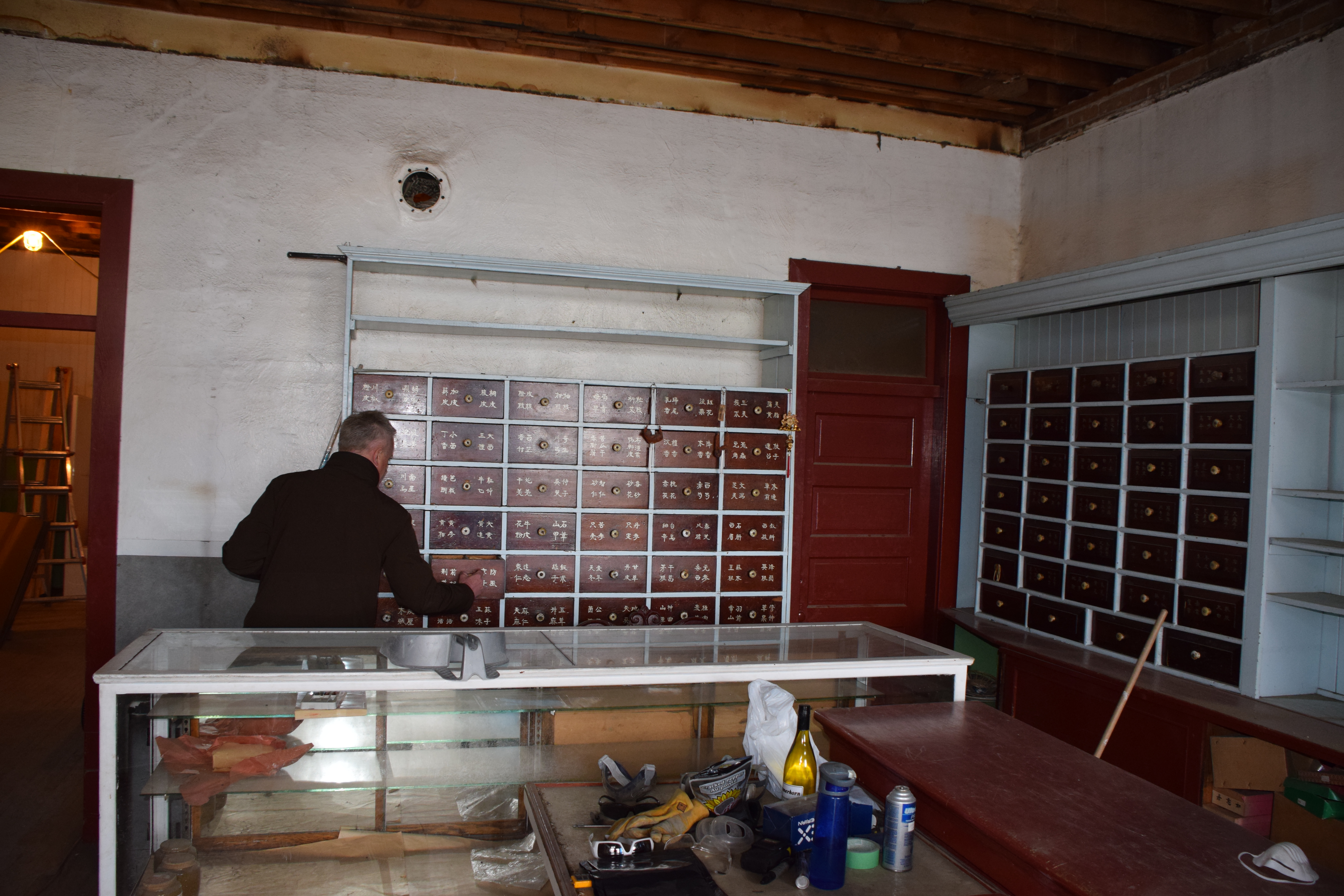
Ted Stilson showing me Apothecary’s showroom and work area. (April 17, 2014)
We peek inside the cabinets to find, well, I’m not sure.
Boxes full of remedies, including “kidney pills”.
A 1907 City bylaw restricting all laundries to this area was enforced only if the laundry was Chinese-owned. Other Chinese-owned businesses followed the laundries into the neighbourhood west of Galt Gardens. The Bow On Tong was constructed in 1916 in the middle of the city block known as Chinatown, on 2nd Avenue South. Beside it stood the Manie Opera House Building (not its original name), built about a decade previously. Lethbridge’s Chinatown had begun.
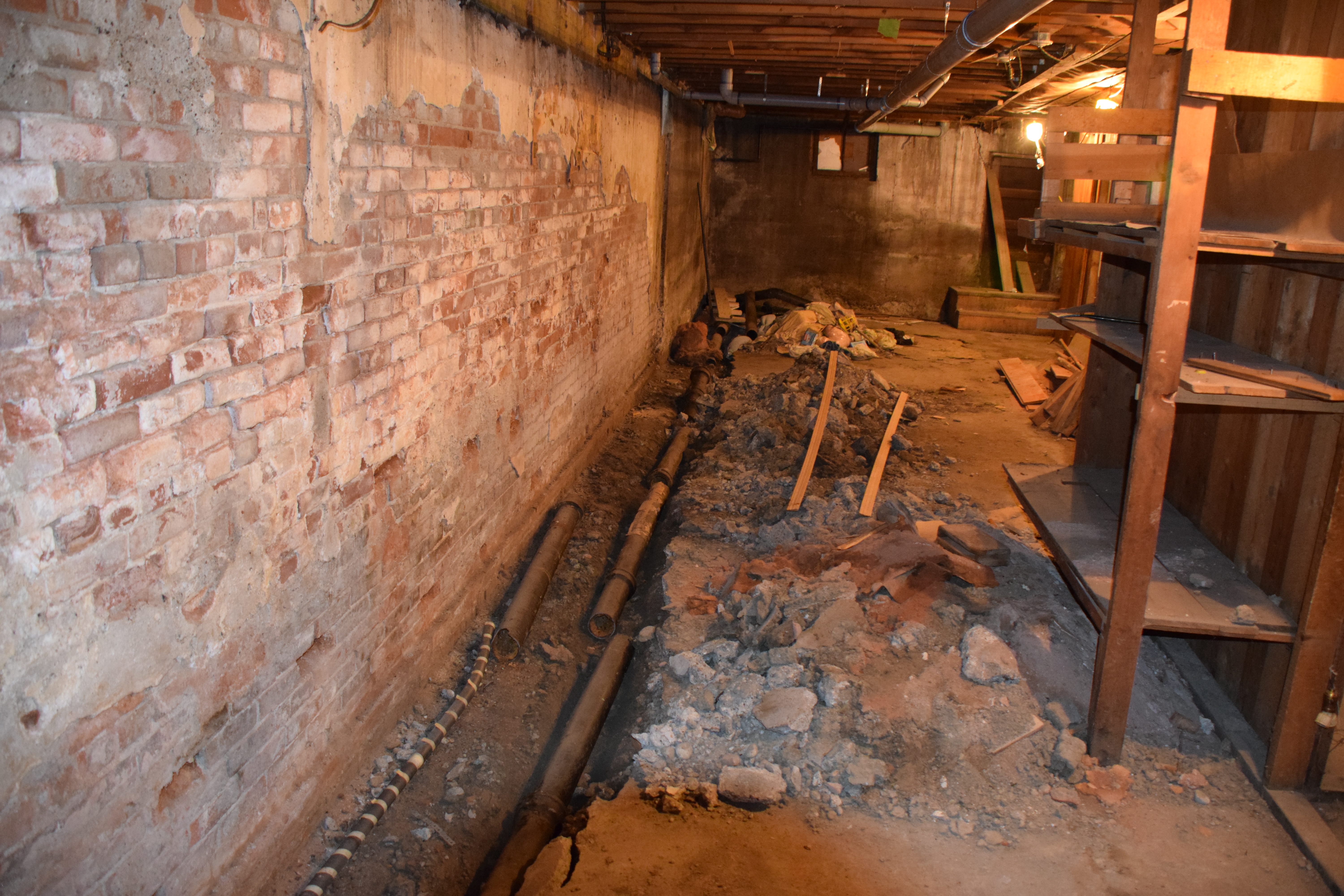
The basement of the Bow On Tong Building in the middle of rehabilitation (April 17, 2014)
My tour of the buildings started on the main floor of the Bow On Tong and was led by Ted Stilson, coordinator of Lethbridge’s Main Street Program, and Kevin Peterson, general contractor for the rehabilitation project. I learned that Way Leong, a Chinese apothecary, opened the Bow On Tong Co. in the 1920s, from where he dispensed traditional remedies to the Chinese community. Shelves and cupboards, labeled with Chinese characters, line the walls of the small shop and tell of Mr. Leong’s practice which operated here into the 1950s. Several of the varnished wood drawers still contain the apothecary’s supplies and equipment. (Unfortunately, while I was there, I did not have the pleasure of meeting Way’s son, Albert Leong, who lived in the building up until rehabilitation work started.)
The basement of the Manie Opera Society is just as interesting. Even with all the construction work going on, I could make out traces of the frail partitions dividing the basement into little rooms. Immigrant coal miners from China once lived down here; their tiny, cramped quarters wallpapered in newspaper still clinging to the walls. A few rooms seem to have been decorated with pictures of American celebrities clipped from magazines—icons of the popular culture of their new homeland.
Kevin Peterson shows us a portion of one of the makeshift walls. Pictures of american celebrities cut out of magazines are everywhere. (April 17, 2014)
Rehabilitation began last year when cracks appeared in the upper wall of the Bow On Tong, leading to the discovery of structural problems throughout both buildings that was slowly causing them to collapse. Major parts of the work are now in progress include the shoring up of a crucial load-bearing wall shared by both buildings and upgrades to meet the current fire code. Even with the urgency of the structural repairs, the work is being done with painstaking care to avoid destroying historic materials. The pressed metal ceiling of the apothecary, for example, has been carefully removed piece by piece. Each piece is numbered and its location mapped before careful cleaning and repainting. After structural reinforcement of the ceiling and the installation of new fire-resistant drywall (required by the building code), the ceiling will be reassembled, with each piece installed in the sequence in which it was removed.
The basement in the Maine Opera Society Building was once wallpapered in newspaper.
Some of the pages are still visible.
The ambitious and painstaking work I saw is a testament to the dedication of the community of Lethbridge, which has supported the project through local fundraising activities and the donated time of many volunteers. Kevin Petersen, the general contractor, has himself contributed much of his own time. When the rehabilitation work is complete, Albert Leong will return to his lifelong home in the Bow On Tong Building. It, and the neighbouring Manie Opera Society Building, will continue the legacy of Lethbridge’s Chinatown.
Written by: Michael Thome, Municipal Heritage Services Officer.
This is the second in a series of posts on our experience attending the National Main Street Conference in Detroit.
I had the pleasure of attending the 2014 National Main Street Conference recently, in Detroit, Michigan. Several Albertans were there with me, including four people representing two of our main street communities: the Town of Olds and the City of Camrose. The (U.S.) Main Street Program has been operating in the United States for over 35 years now. As Alberta continues to revitalizes our its Main Street program, we continue to learn from the American counterpart.
The Canadians after the opening plenary session. Each american state formed a delegation, so we formed one of our own.
In the late 1970s, the (U.S.) National Trust for Historic Preservation was exploring ways to facilitate the preservation of historic downtowns. All over North America, businesses and residents had been leaving downtown and moving to new suburban neighbourhoods and consequently many historic places were neglected and being abandoned. The National Trust realized that solving the problem would not be as simple as restoring dilapidated buildings; restoring historic commercial areas meant bringing people back down town. It launched a three-year Main Street Project in 1977 to study ways to revitalise declining downtowns. The main street pilot project was so successful that it was made a permanent program in 1980 and was soon helping hundreds of communities throughout the United States revitalise their historic commercial areas.
A Main Street project works by pursuing four equally important activities: organizing business owners and residents around a common purpose; economic restructuring or strengthening the existing businesses while also diversifying the mixture of business types; designing a functional and pleasant streetscape that highlights the authentic historic places; and promotion, or rekindling a sense of pride in the downtown. Economic restructuring ensures that businesses are successful and the Main Street is able to pay its own way. Design ensures that Main Street has a functional and pleasant streetscape—built around authentic historic buildings—and creates an inviting place that people want to work, live and play in. Promotion ensures that the community (and visitors from away) know what the area has to offer and feel welcome. Organization ensures that business owners, residents and other stakeholders take shared responsibility for the success of their downtown.
The keynote by Donovan Rypkema presented a straightforward and compelling explanation of how the program works and why it works so well. (Mr. Rypkema is an internationally regarded specialist in the economics of historic preservation.) He argued that Main Street is the most effective, sustainable and “cheapest” economic development strategy he’s come across, for historic areas or otherwise. This is because the four pillars of a Main Street align with the four factors that set the value of real estate.
Mr. Rypkema compared the four pillars of Main Street (design, organization, economic restructuring and promotion) with the four forces of value: economic, physical, social, and political. Mr. Rypkema talked about how Main Street works because each of the four points is aimed at increasing a corresponding area of value. When an area restructures economically by ensuring a mixture of complementary businesses, it increases the number of visitors and therefore the profitability of each business and consequently the value of the real estate.
A Main Street Program adds to the physical value of property when it restores dilapidated historic places and otherwise upgrades the streetscape. It adds to the social value of property by improving how the community feels about the area, by increasing local pride in a historic area. Finally, it adds to the political value of property when the range of possible, profitable and acceptable uses increases. He calls it the most successful economic restructuring programs ever tried in the United States. (On a somewhat related note, Mr. Rypkema joked that Main Street was working on smart growth and new urbanism before these planning philosophies were proposed.)
The best part about the conference was the opportunity to learn from peers in the Main Street movement. There were excellent sessions around all the four points. I attended lots of sessions on using social media effectively (big surprise) and community organization. I highly suggest that anyone interested in these ideas look into the National Main Street Center. I look forward to perhaps attending next year’s in Atlanta, Georgia.
Written by: Michael Thome, Municipal Heritage Services Officer.
The tall silhouette of a wooden grain elevator on the horizon once symbolized rural landscape across the prairies. “Against open space,” in the words of distinguished American photographer Frank Gohlke, “grain elevators were the presence against which that emptiness could be measured.”
A long row of eight elevators had been built at Vulcan by 1924 and provided a backdrop for this harvest scene at Vulcan. (Glenbow Archives, ND-8-218).
Early Elevator Row
In 1891, the Calgary and Edmonton Railway built Siding 19, soon to be named Leduc, on the west side of its mainline. The length of the siding—long enough to build a row of six elevators—showed the railway’s faith in the district’s grain growing potential. By 1905 a row of three elevators lent a vertical silhouette across the tracks from the station. The first grain company to build at a new siding tried to choose the best position for attracting customers, and for loading cars with the greatest ease. Each elevator had sufficient space on the siding to load two grain cars. Elevator construction along the Calgary and Edmonton railway set a pattern followed across Alberta as main lines and branch lines slowly spread their reach.
As elevator rows developed they created a varied sky line: there was considerable difference in size and shape of elevators built from the 1890s to the 1920s. After 1920 many of the early variants were replaced and grain companies built traditional elevators with a gable roof and a gable roofed cupola on top. Wood clad elevators were almost always painted CPR red, and what differentiated each company’s elevator was its name (and its logo, if it had one) painted high up on the walls, emblazoned in white along with the name of the town. In contrast, metal clad elevators were galvanized or painted white.
Elevators Everywhere
Competition between the grain companies resulted in the rapid emergence of rows of elevators at the most significant grain delivery points. By 1911 there were 142 sidings with grain elevators, and 43 of them had three or more elevators. Carstairs, High River and Nanton, along with Edmonton and Calgary, had five elevators, while Westaskiwin had six. Eight years later, in 1919, the total number of elevator delivery points in the province totalled 334, of which 150 had three or more elevators. Barons had emerged as the point with the longest row of elevators, with eight, followed by Nanton with seven. A number of towns had six: Blackie, Bow Island, Carmangay, Chinook, Claresholm, Cluny, Gleichen, Granum, Magrath, Oyen, Provost, Vulcan, and Youngstown. Edmonton and Calgary also had six. The points with the largest elevator capacities were mainly in the wheat-growing area of the southern part of the province, but by the 1940s as farming thrived in the Peace River country, impressive rows evolved at Sexsmith and Grimshaw. Vulcan in southern Alberta however, holds the record for the longest row—12 elevators in 1956.
The elevator row became a towering beacon for Alberta’s growing hamlets, villages, and towns with bustling commercial main streets and residential areas. Through the 1950s into the 1960s a long unbroken row symbolized prosperity. A town with five elevators rather than three had a more lucrative tax base and better services, all of which could be traced back to its life line—the railway.
Barons, 1913. (Glenbow Archives, NA-2059-27)
Elevator Consolidation Begins
From the 1960s, as paved highways increasingly linked Alberta’s major towns with hamlets and rural districts, and one railway station after another closed in smaller centres and on branch lines that were being abandoned, farmers chose to take their business to larger centres. Farmers benefitted from the competition between elevators at larger centres, and grain companies closed more isolated grain buying points due to loss of business, the threat of further branch line closure and changes in car allocation rules. Grain companies consolidated their elevators making for longer rows at fewer points. Towns that had secured multiple elevators flourished; the more elevators in a town, the greater its prestige and the better its prospects for business and further development seemed to be.
All the Colours of the Rainbow
It was in the 1960s that elevator row began to take on the appearance that many of us remember. The grain companies repainted their elevators when the CPR red began to fade. First came white, adopted by the United Grain Growers. A splash of colour marked the beginning of modern company branding. First came white, adopted by the United Grain Growers. Pioneer Grain Company first painted the shingled roofs of their elevators yellow, and then in 1962 went for bright orange on the elevator walls, complemented by yellow roofs. The story goes that on the Victoria Day weekend in 1962 as a Pioneer engineer and his wife toured the countryside, she suggested orange (the colour of her pants that day) would cheer up the appearance of the elevators on the landscape. The company agreed to the experiment and the first dazzling orange elevators on prairie rows surprised everyone. Federal Grain adopted white by the time it took over Alberta Pacific Grain (1943) Ltd. in 1968. The Alberta Wheat Pool adopted a turquoise green colour, which slowly dominated the rows after 1972 as AWP took over Federal Grain in 1972, painting all the white Federal elevators turquoise-green as well. Parrish and Heimbecker adopted a mustard colour in 1976.
The Fall of the Sentinel
More change came to elevator row as the grain companies began to replace ageing elevators with larger single and double composite elevator designs in the 1970s. The sky line began to transform as holes began to appear in the great Alberta rows. By the 1980s elevator row was gap-toothed. Grain companies rapidly consolidated business on sidings where there was enough room to fill more grain cars at one time. Then in 1995 the federal government ended the Crow Rate that subsidized freight rates to the port terminals, and deregulated the railways in 1996. The economy of scale changed. In 1997 there were still major rows of elevator complexes that sometimes included an older elevator as an annex: six at Hussar, six at McGrath, six at Sexsmith, five at Standard, four at Arrowood, and four at Champion and finally seven at Warner. The same year, scores of unwanted elevators, many remnants of once proud rows began to fall. Finally, at the turn of the 21st century, operating grain elevator rows were completely replaced by large inland concrete terminal silo-style structures. Warner is an aberration: with six of its original traditional elevators (forming four elevator complex facilities) still standing and used to handle the local mustard crop, it is a significant legacy of a vanished skyline.
Written by: Judy Larmour.
Barons, 1913. (Glenbow Archives, NA-2059-27)
A long row of eight elevators had been built at Vulcan by 1924 and provided a backdrop for this harvest scene at Vulcan. (Glenbow Archives, ND-8-218).
Elevator row at Vegreville in 1926 illustrates the variety of heights and shapes that defined Alberta’s skyline. (Provincial Archives of Alberta, B.2749.)
Elevator row at Consort, 1950s. (Provincial Archives of Alberta, PA116.2.).
Warner elevator row as it appeared in 1997. Today the six elevator row at Warner, albeit with modifications, is the longest elevator row standing in Alberta. (Alberta Heritage Survey, 97-R0297-09a).
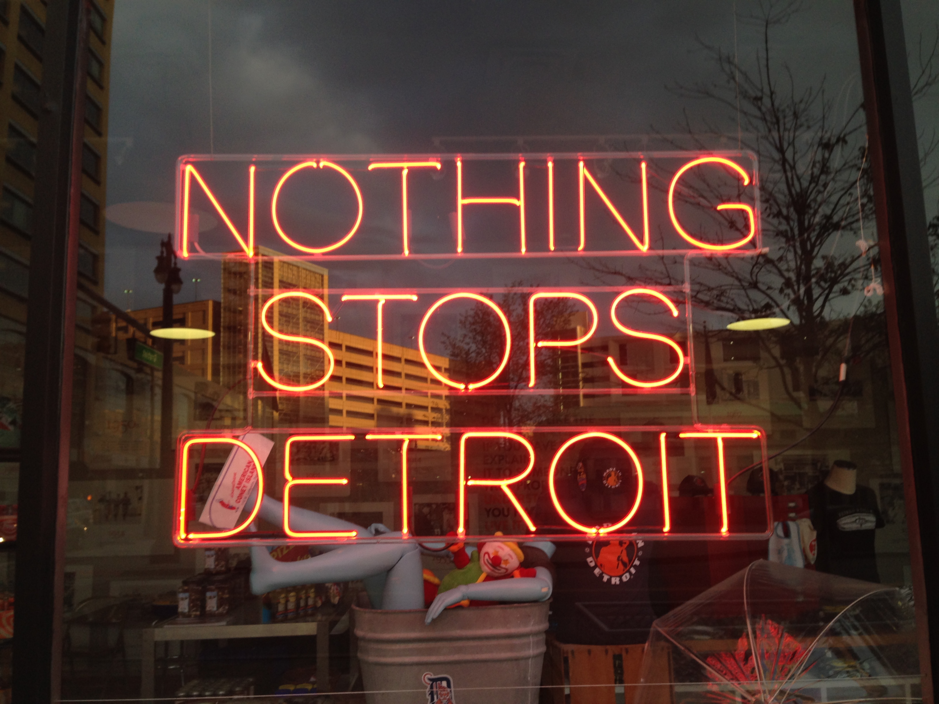
You have no doubt heard of the trials and tribulations of the City of Detroit: the near death of the auto industry, massive population loss, infrastructure woes and high crime rates. The negative connotations have led to a public image of a city abandoned and in upheaval whereas the best-case-scenario associations portray it as a playground of urban decay and rock-bottom housing prices. When I learned that the National Main Street Conference was being held in Detroit this year, I was pleased that I would be able to see it for myself, albeit in the cocoon of a programmed conference setting.
Having now been there I can make a few comments. First, it is a stunning city. There are architectural marvels (both in use and abandoned), striking parks and trail networks and an eclectic mix of things to do. Second, the city is hard at work. Travelling in and around the downtown core, there is evidence of a community working to rebuild and repair. Third, the city seems to be acutely aware of the volunteerism and resources required to improve its image. Bike patrols and on-foot clean-up crews strive to ensure the downtown core is safe and clean. Residents are cheerful and exceptionally welcoming.
This said, did I really see Detroit? Visiting as part of a conference I no doubt had a curated experience of the city and limited time for exploration. It is important to remember that there are layers that we do not understand: a history of labour and race disputes, urban renewal programs and community activism. There is a long-standing population who is probably growing weary from being under the microscope. I would encourage everyone to visit and appreciate the people, public spaces and community spirit, along with the many restaurants, sports events, markets, museums, and music that make up Detroit. However, visit with an appreciation of the modern urban realities facing the city. Acknowledge and be aware of the complex layers of economic, social and political issues (past and present) that continue to inform the fabric of the city. Detroit is a fascinating and many-faceted city and I would encourage you to make the trip.
This slideshow requires JavaScript.
Stay tuned for upcoming posts about the content of the National Main Streets Conference!
Written by: Rebecca Goodenough, Municipal Heritage Services Officer
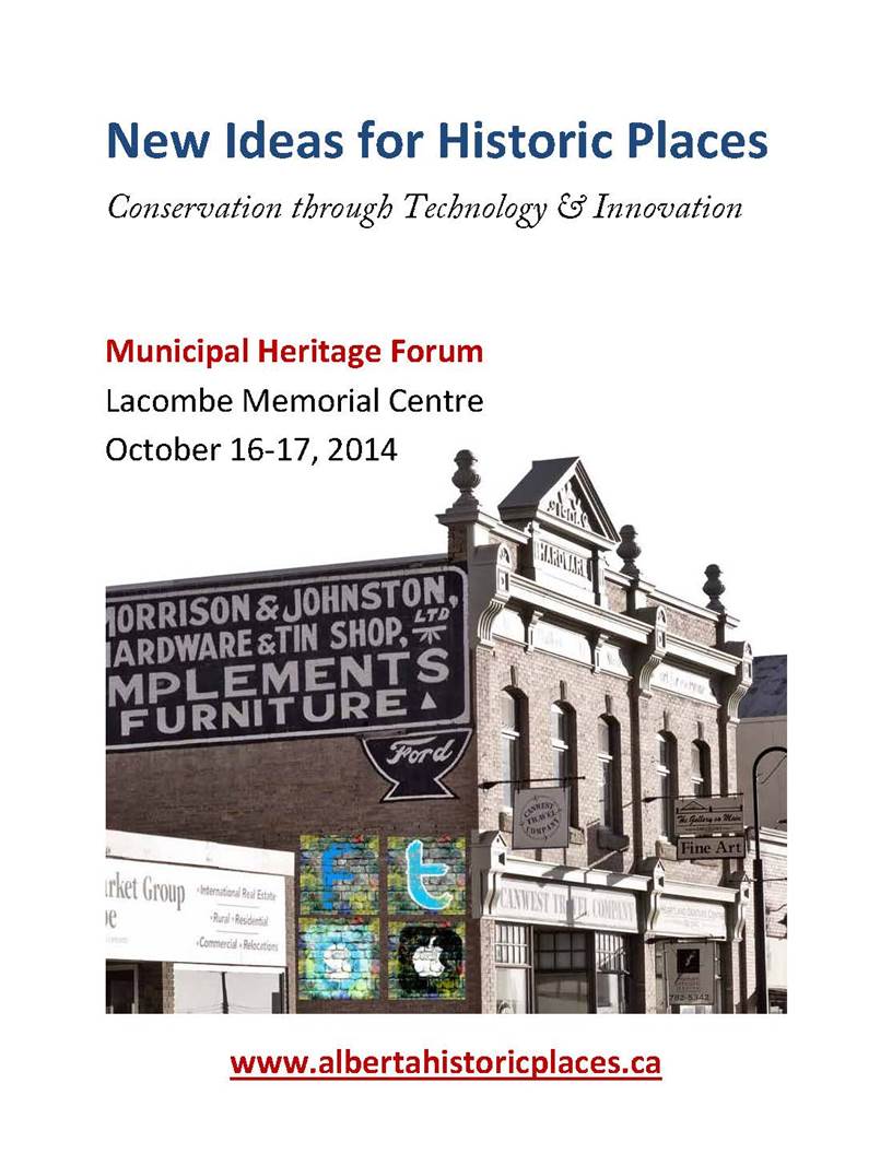
As previously announced, the 2014 Municipal Heritage Forum will be held on October 16th and 17th at the Lacombe Memorial Centre with sessions to be held in and around their award winning Main Street. The theme of this year’s forum is “New Ideas for Historic Places: Conservation through Technology and Innovation”. We are planning some exciting sessions to get you thinking about social media, mapping and documentation as well as workshops on using technology for building conservation. We hope to see you there! Registration will open and keynote speakers will be announced in June.
(Note: social media graffiti not actually real!)
For those of you who have attended past Forum’s you will be familiar with the Municipal Show and Tell sessions. Show and Tell is an opportunity for municipalities and volunteer groups to present projects they have been working on to their peers. It is a great way to learn about different heritage initiatives and to make valuable contacts for the future. The challenge we always have organizing Municipal Show and Tell is that you heritage conservationists are a humble group – many of you don’t realize how interesting your projects are and how much others can learn from you. Year after year we get feedback telling us how valuable the Show and Tell is to participants so we strongly encourage you to send us your ideas or recommendations! Presentations are approximately 15 minutes long, with time for questions included. If you would like to forward an idea for the Municipal Show and Tell e-mail us at albertahistoricplaces@gov.ab.ca.
This slideshow requires JavaScript.
Written by: Rebecca Goodenough, Municipal Heritage Services Officer
The Town of Sexsmith is now one step closer to completing their first Municipal Heritage Inventory. On April 30th the Town, in partnership with project consultant Donald Luxton and Associates Inc., held a public open house to present information on the Heritage Inventory project to the community. Approximately 14 residents attended the session to review possible themes related to the development of their community and to provide information on specific buildings.
The following day the Town’s Heritage Advisory Board (HAB) met to review the proposed Statements of Significance for 16 potential locally-significant historic resources within Town boundaries. Their local knowledge of the people and events from Sexsmith’s past provided the project consultant with valuable information. Revisions will be made to the Statements of Significance and we anticipate the final report will be presented for review by Town Council by the end of summer.
Participants in the Sexsmith Heritage Inventory Project (From left to right): Chelsea Dunk (Donald Luxton & Associates Inc.), James Obniawka (HAB), David Olson (resident), Larry Anderson (HAB), Vella Anderson (HAB), Carolyn Gaunt (Town of Sexsmith), Jean Rycroft, Sam Boisvert (Donald Luxton & Associates Inc.). Missing from photo: Grant Berg, Isak Skjaveland
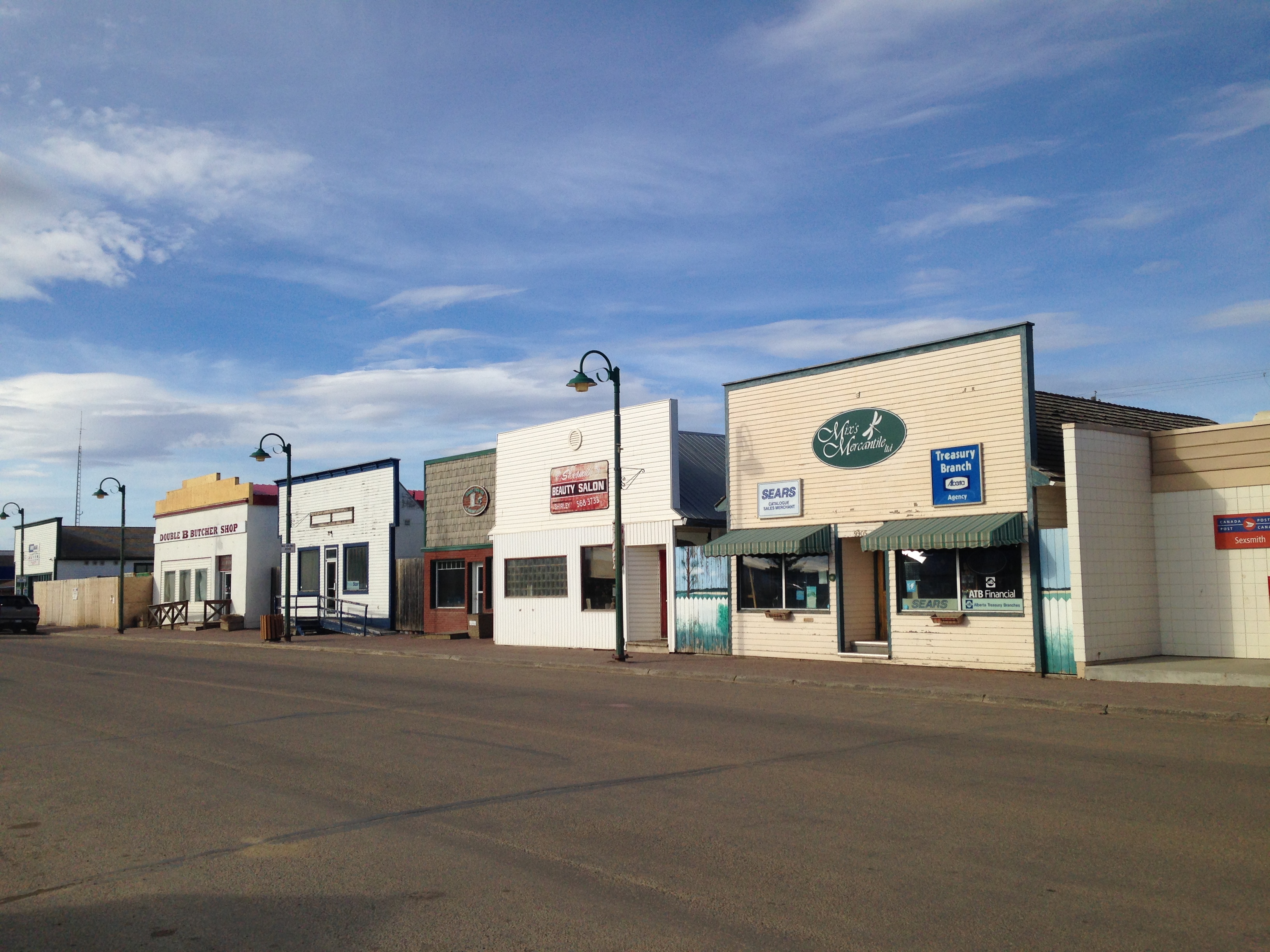
Originally known as Benville, Sexsmith was first settled in the early 1900s but experienced growth following the establishment of the ED&BC railway in 1916. The proximity of the community to the rail line caused expansion of agricultural production and established Sexsmith as a major hub for grain export. Sexsmith was once known as ‘The Grain Capital of the British Empire’ during the 1920s and 30s and at one time there were nine grain elevators situated adjacent to the railway. Today three remain and the Town is in the process of acquiring one for conservation purposes. The community is further characterized by its relatively intact boomtown commercial main street, located directly opposite of the rail line and by the presence of two Provincial Historic Resources: the Northern Alberta Railway Station and the Sexsmith Blacksmith Shop.
100 Street (Main Street), Sexsmith
Heritage inventory projects are supported by the Municipal Heritage Partnership Program and provide municipalities with the process and tools to assess possible historic sites within their boundaries for future municipal historic resource designation.
Written by: Rebecca Goodenough, Municipal Heritage Services Officer
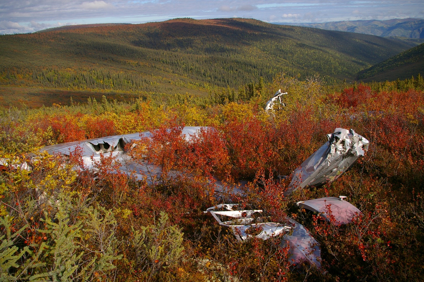
Plane wrecks are unique and dramatic physical records of human movement. We document here the archaeology and history of a 1952 B-17 plane crash to help illustrate the deep and fascinating roots of northern aviation. We reconstructed mission details from accident reports and discovered interesting connections to the famous Northwest Staging Route, which was a significant transportation network that spanned Alberta.
Scale of the SB-17G and the 8 crew members on the ill-fated 1952 flight (diagram T. Kristensen).
On July 11, 1952, a modified B-17 (an SB-17G) set out from Alaska on a search mission in the Yukon to locate a crashed Royal Canadian Air Force plane that had disappeared in June. The B-17 was originally a Second World War era high altitude bomber, legendary for the damage it could endure in combat. Its durability, combined with the availability of surplus aircraft after the war, meant that B-17s were used for many post-war activities including weather survey, forest firefighting, and search and rescue.
Mountainous terrain in which the SB-17G met its untimely fate (photo T. Kristensen).
Eight crew members of the United States Air Force 10th Air Rescue Squadron were aboard the SB-17G as it entered a small mountain valley. The navigator was unfamiliar with local topography and 15 seconds into the valley, the crew began adjusting power in an attempt to avoid a fast approaching valley wall. Because of its original purpose in high altitude flight, the SB-17G was not particularly maneuverable and couldn’t recover from its predicament. Stalling within meters of the ground, the left wing struck an alpine slope sending the aircraft into an arching skid path that tore through birch trees and bedrock cobbles for several hundred meters before coming to rest. The wreck was quickly consumed by flames. Five men evacuated immediately but the remaining three caught fire in their frantic attempts to depart. An heroic lieutenant escaped the wreck and pulled one man to safety while another emerged from the wreck engulfed in flames. Although he was immediately doused, the airman couldn’t recover from severe burns and died six hours later. The crew spent a somber night in the cold mountains before being rescued the next day.
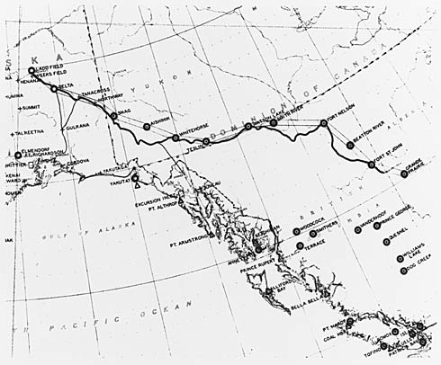
Northwest Staging Route in Canada and Alaska. Yukon Archives. Department of Defence Collection, 91/37 #51, PHO 419.
The story of the SB-17G crash represents a small but significant piece of aviation history. Northern aviation assumed an international importance with the growth of the Northwest Staging Route in the 1930s. The Canadian portion began in Edmonton and linked a series of northern airstrips up to Alaska and Russia. Like Edmonton, most towns along the route were initially First Nations gathering spots that developed into fur trade posts when traders arrived. They eventually grew into agricultural, mining, forestry, or oil and gas centres. The Alaska Highway was built to connect these centres to help protect North America from a potential Pacific attack. After the war, the Northwest Staging Route remained important for military exercises (which drew the SB-17G to the Yukon) and as a transportation route to other international conflicts.
Reconstructed flight path of the SB-17G to its final resting spot (photo T. Kristensen).
Given their experience on the land, First Nations people were hired as guides to help survey the Alaska Highway before construction. Consequently, much of the highway followed First Nations trails that existed for millennia. Other portions followed Gold Rush trails that started to criss-cross the north in the late 1800s. This synopsis illustrates how modern transportation systems in the north have deep histories. The interconnected travel network that now links northern towns has witnessed birchbark canoe paddlers, moccasins, Gold Rush wagons, tank treads, and jet streams.
SB-17G (S/N 44-83722) used in the US Military Air Rescue Service (photo credit 060526-F-1234S-009.jpg, National Museum of the US Air Force).B-17G-50-VE (S/N 44-8167) during in-flight high altitude bomb drop in WWII (photo credit 050610-F-1234P-011.jpg, National Museum of the US Air Force).B-17F flying fortress formation in WWII (photo credit 050615-F-1234P-006.jpg, National Museum of the US Air Force).SB-17G propeller and engine (photo T. Kristensen).SB-17G gear wheel (photo T. Kristensen).Charred measurement tags from SB-17G (photo T. Kristensen).Canister from SB-17G (photo T. Kristensen).Wreckage of the SB-17G overlooking the valley it was unable to climb (photo T. Kristensen).
Territorial and provincial heritage legislation exists to preserve the remains of historic events like the SB-17G plane crash. A research permit is required to excavate any historic resource be it a 2 million year old fossil, a 2000 year old fishing camp, or a Second World War era aircraft. Historic objects are not permitted to leave the territories or provinces unless authorized by respective governments, which means artifacts can’t be re-located without permission. This legislation has created some conflicts in the past between heritage managers and people interested in salvaging plane wrecks but positive relationships and advance communication can help ensure that aviation historians and archaeologists work together to share their passion for the past. The story of the SB-17G crash highlights the military importance of the north and the historical depth of human movement.
Written by: Todd Kristensen, Northern Archaeologist & Mike Donnelly, Archaeologist.


")
")

")
")