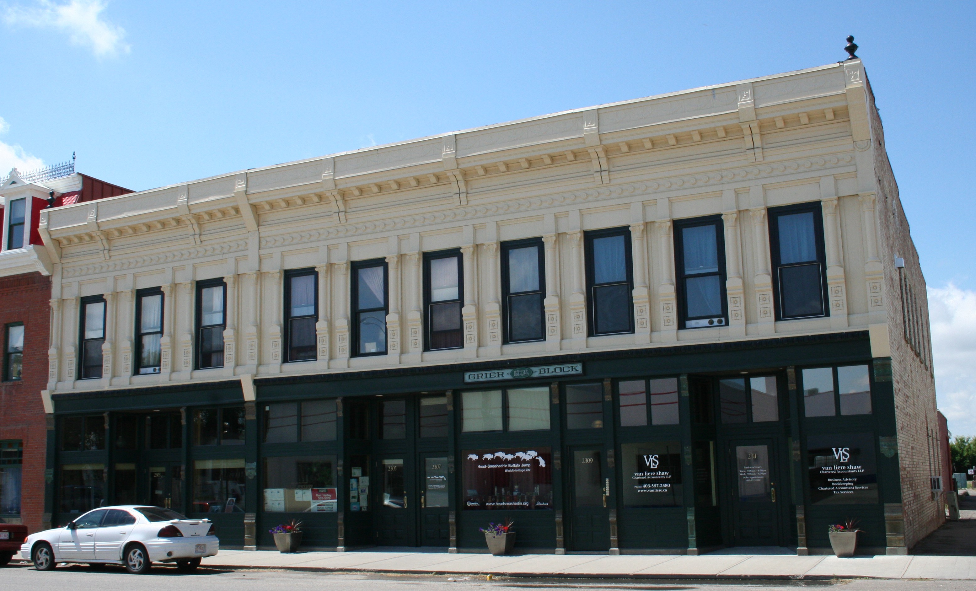
The Grier Block, built in 1902, was one of the first and largest commercial buildings in Fort MacLeod. It has one of the only pressed-metal facades in western Canada, highly decorated with an elaborate cornice and pilasters (columns between the window bays). Peter Maas recalls that by the early 2000s, when he and his brother Hans purchased it, the once-distinguished building was “pretty dilapidated.” The brothers spent seven years on a major rehabilitation (working full time, without pay, living on the premises) that brought the building back as a prominent and attractive contributor to Fort Macleod’s historic downtown. They recently added some long-missing and key elements, returning the building to its full glory.
The rehabilitation work included adding insulation and making other upgrades to the building envelope (the outer shell separating the interior from the exterior), accurately replacing the historic windows and frames, and preserving the original pressed-metal facade still present on the upper floor. (For a detailed account of the rehabilitation of the Grier Block, see pages 6 to 9 of the Standards and Guidelines for the Conservation of Historic Places in Canada.)
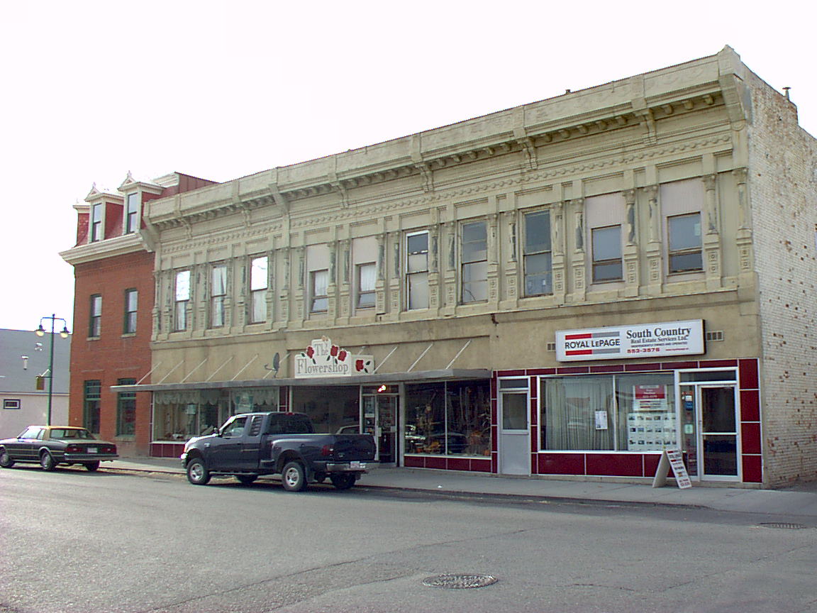
Unfortunately, the first-storey cast-iron pilasters had been missing since the 1960s, so the brothers only restored what was there at the time. It was fairly common to remove decorative facades from commercial buildings during the 1950s, ’60s, and early ’70s, says Fraser Shaw, the Heritage Conservation Advisor for Southern Alberta. Ground-level elements corrode more readily. Also, at mid-century, out-of-fashion ornamented facades were often modernized at street level, as this one was, with expanses of plate glass windows with plain surrounds.
The brothers were never satisfied with what they considered an incomplete restoration: “That was the only piece to the puzzle that was missing,” Peter says. “We’ve gone 100 percent on everything else, and that was the only thing that was left to attend to, so it was important to us to have that finished.”
Now—thanks to their perseverance, resourcefulness, and the lucky confluence of the right people at the right time and place—those first-storey pilasters have been replicated and are back in place. It’s “the crowning touch…the icing on the cake,” says Fraser. The building is designated as a Provincial Historic Resource, so his role during both the original rehabilitation and this project was to verify the historical accuracy of the proposed changes and monitor the work.
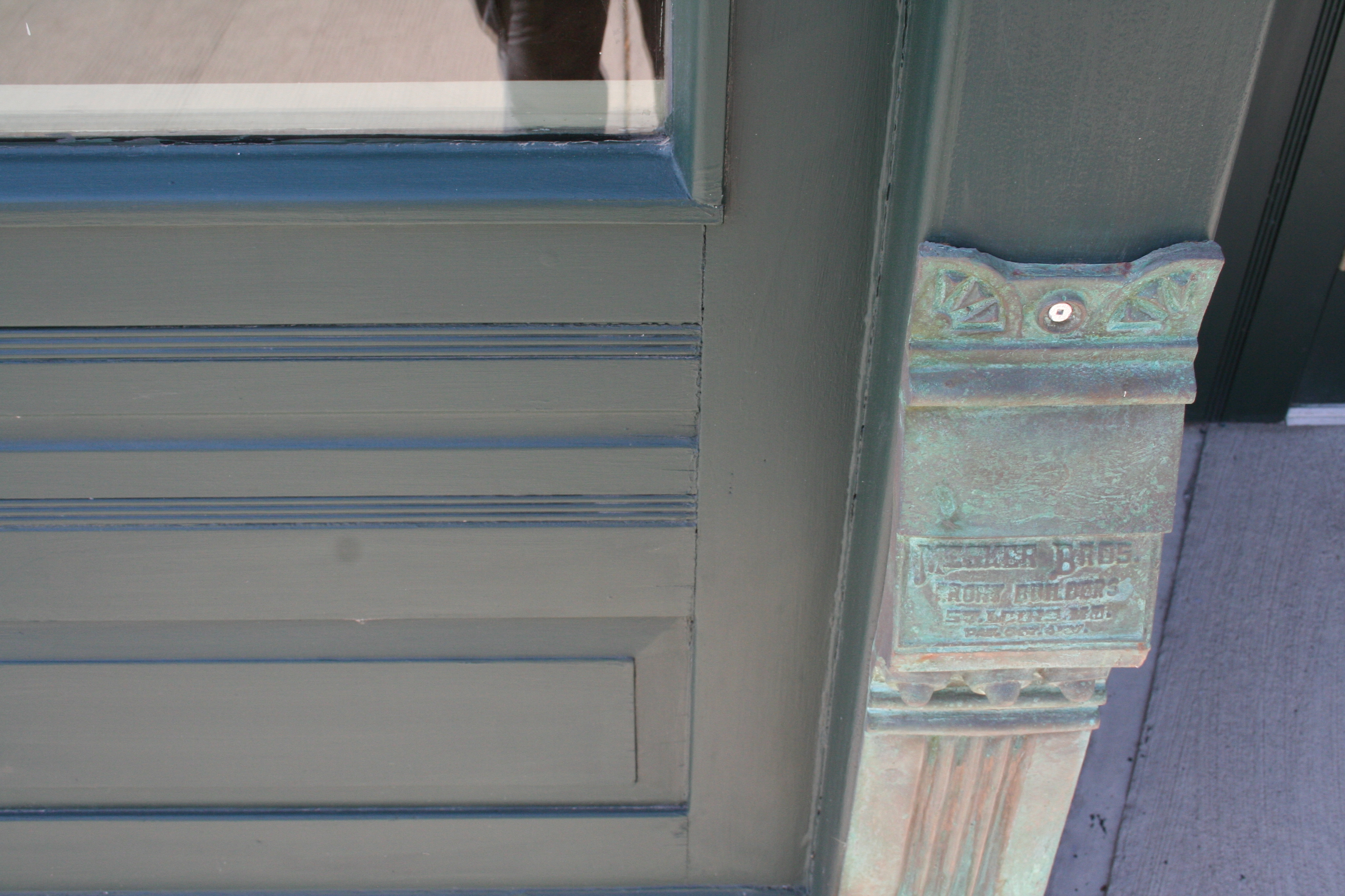
During the rehabilitation project, the architect in charge, Robert Hirano, made an important discovery: the building has a Mesker Brothers facade. In the late 1800s and early 1900s manufacturers introduced mass-produced prefabricated building components made from sheet-metal panels stamped with decorative motifs and iron elements cast in moulds. These processes provided an easy and inexpensive way to imitate elaborate decorations that historically had been created by craftsmen in more expensive materials such as carved stone. The products were sold through mail-order catalogues and shipped by rail throughout North America. Mesker Brothers Iron Works of St. Louis, Missouri, was one of several companies that created and shipped entire building facade and storefront assemblies. (One competitor was the George L. Mesker Company of Evansville, Ind., owned by another brother.)
Buildings with Mesker Brother facades are plentiful in the U.S. East and Midwest, with numerous Western examples as well, especially in Colorado, Wyoming, Montana, and Washington. The Grier Block has one of only a handful of Mesker facades known to have existed in Canada, with two other Mesker facades installed in nearby Lethbridge—the Metcalfe Block (“Club Cigar”) and Lethbridge Hotel—no longer surviving. Fraser speculates that the developer of the Grier Block might have had U.S. connections, and benefitted from convenient cross-border rail service between southern Alberta and the U.S.
Over the years, Peter Maas had been hunting for Mesker storefronts with pilasters identical to those that once graced the Grier Block, hoping to replicate them. Specifically, he needed to find models for pilasters that are six inches and thirteen inches wide, each with a lower, a middle, and an upper component. All together, 33 individual elements needed to be produced to complete the lower facade.
The original structural steel pilasters of the Grier Block were still intact. Outlines of old paint showed where the ornamental cast-iron pilasters had been, and there were even tool marks showing where they had been hacked off. The owners had historic photographs of the building and the Mesker Brothers catalogue to show how the missing elements should look, and Hirano had produced drawings. “But at the end of the day, you need something that’s full scale and more tangible” to create the accurate, full-sized building elements, Fraser says.
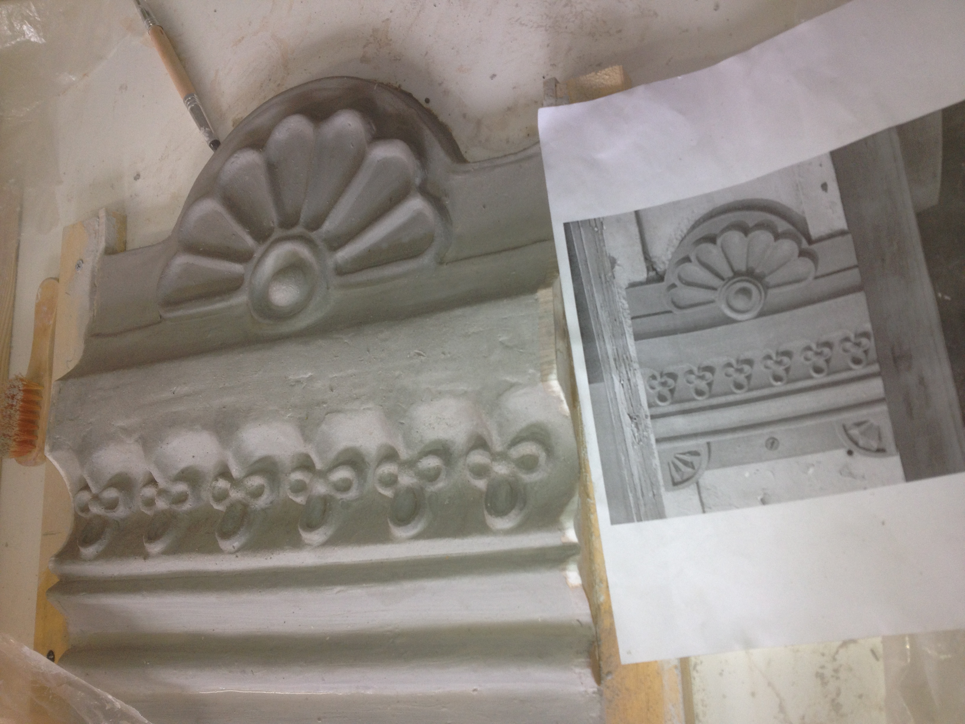
During the rehabilitation work, the Maas brothers hired a carver to create the pilasters out of wood, but the result was disappointing. Later they located a Mesker Brothers building with one of the two needed sizes of pilasters while vacationing in New York State, and used those to create rubber moulds. But because those pilasters had decades of encrusted paint, the resulting moulds lacked definition.
Then everything came together last year when Peter was on vacation in Colorado.
Always on the lookout for Mesker Brothers buildings, he tracked one down in the small town of Mancos, in southwestern Colorado near Durango. It had the six-inch pilasters he needed! While gazing at them, he struck up a fortuitous conversation with a passer-by. That was Collette Webster, a professional potter. She considered how to replicate the pilasters, then came up with a solution.
Remarkably, the building owner allowed them to temporarily remove the pilasters. Collette was able to make plaster moulds of the three sections, and from those make clay templates that could be used for casting the elements in metal through the lost wax process.
On the same trip, Peter found a Mesker Brothers building with the thirteen-inch pilasters on the main street of Telluride, Colorado. In that case, the pilasters couldn’t be removed, so he took lots of photographs. Collette referred to those and to the moulds for the six-inch pilasters to create scaled-up models in wood of the thirteen-inch pilasters. These could then be used to make the necessary plaster moulds and wax models.
Some decorative detailing was still needed. As a potter, Collette was able to craft the missing roundels, florets, and other flourishes out of clay and then attach those shapes to the templates used to create the wax models.
The sections were cast in bronze by craftsman Dimitry Domani at his foundry in Cortez, Colorado, then shipped to Sweetgrass, Montana, for Peter to collect at the border. Domani recommended using bronze rather than the original iron because it has the potential to develop an attractive natural patina over time, whereas the iron would need to be painted.
The Grier Block’s new pilasters are now bolted into place, as they would have been historically, and also welded on “as an extra safeguard,” Fraser says.
“In all, the project seems to have been a lucky convergence of passionate owners, Mesker buildings in Colorado to serve as templates, and a network of local (in southern Colorado) artisans to perform the work where the buildings were,” Fraser concludes. The project was assisted by a matching conservation grant from the Alberta Historical Resources Foundation.
Today the Grier Block is fully occupied. On the first-storey are an insurance and a real estate agency, a stained-glass artisan, a visitor display and offices for Head-Smashed-In Buffalo Jump, and one residential suite; the second storey contains seven residential suites.
“There’s no question that it’s an anchor within the historic commercial district,” Fraser says. And “now the building just resonates with character in a way that it didn’t before.”
“It’s a nice piece of history for the town,” Peter agrees.
Hans Maas, a chef by training, had completed the historic rehabilitation of a smaller Fort MacLeod building as a “hobby,” Peter says, before tackling the Grier Block. Peter had experience constructing new buildings, but this was his first historic rehabilitation project. “I’m addicted to historic buildings now,” he says. “I find the historical projects are way more rewarding…You’ve got to go back to good material and quality workmanship.” He has since purchased and is now hard at work restoring Fort MacLeod’s Reach Block.
Written by: Kerri Rubman.