Queen’s Hotel, Fort Macleod

Mid-way through last year, the Queen’s Hotel in Fort Macleod was added to the Alberta Register of Historic Places. The Queen’s Hotel was designated as a Provincial Historic Resource on May 22, 2012. The building was deemed to possess heritage significance as it is an excellent example of the type of substantial hotels built in Alberta’s urban centres during boom periods of the late 1800s and early 1900s. The hotel also contributes to the heritage character of the Fort Macleod Provincial Historic Area.

The Queen’s Hotel, Fort Macleod, 2007. DSC_8336, Historic Resources Management Branch

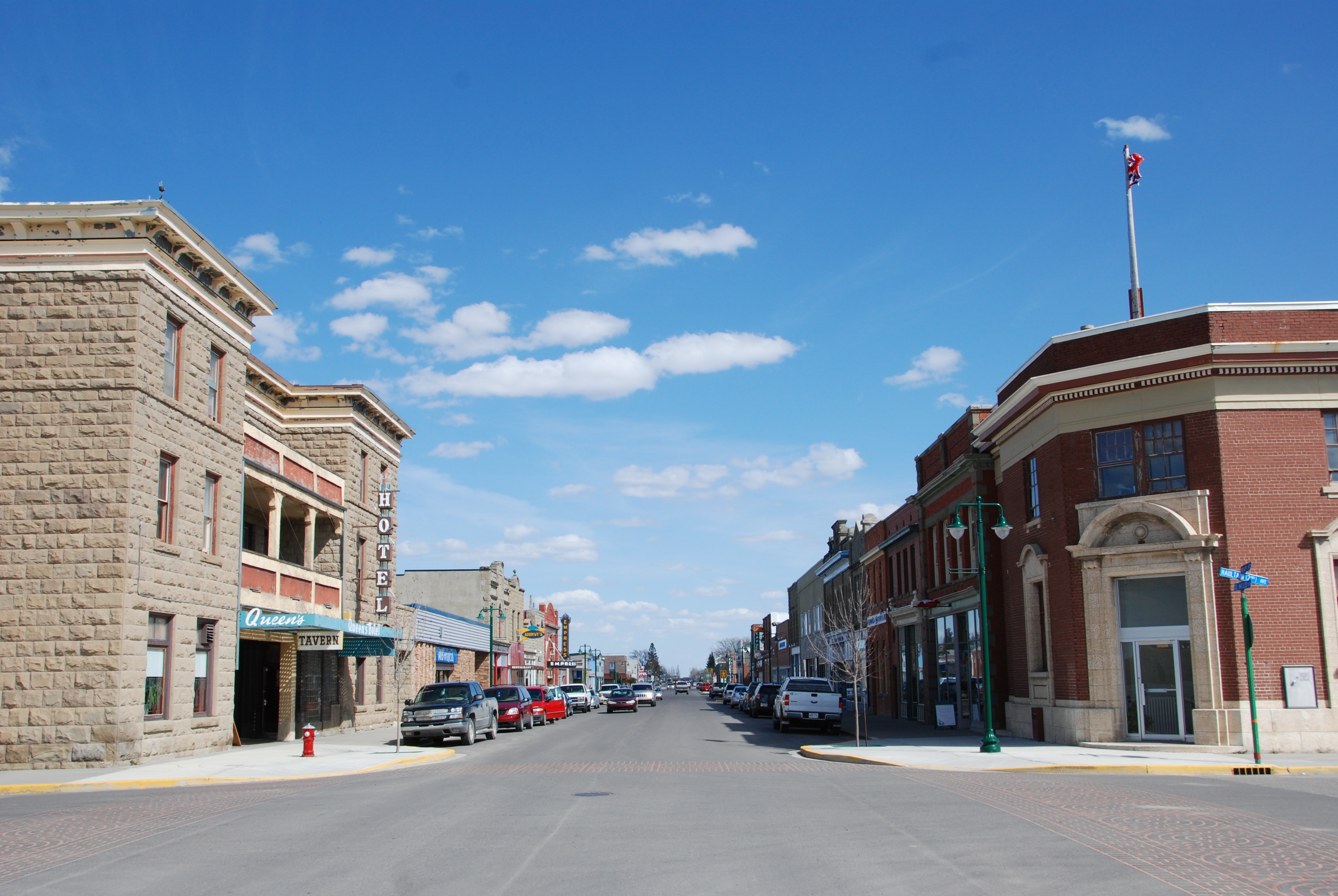
Fort Macleod was one of Alberta’s earliest and most important urban centres during the settlement period. As a thriving commercial hub and service centre for the surrounding ranching and farming communities, a number of buildings were constructed in the town’s downtown area. Locally-quarried sandstone became the building material of choice, largely due to its fire-proofing properties and the sense of stability and permanence it lent to the business and town.

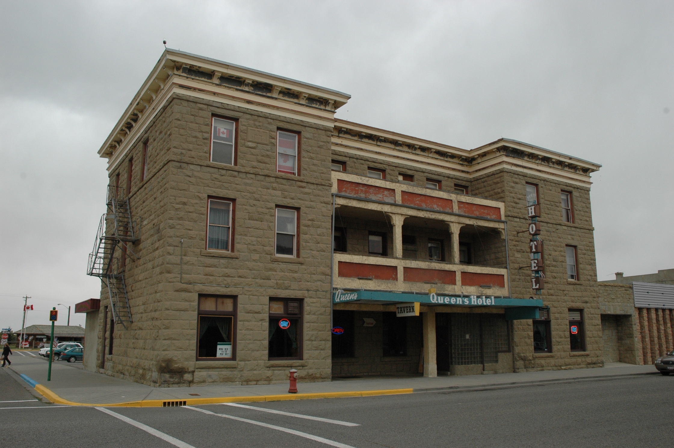
The Queen’s Hotel was one of the first buildings in Fort Macleod to be built of sandstone. It was built in 1903 to replace an earlier, smaller, wood-frame hotel of the same name. The hotel is a three-storey, flat-roofed building with a U-shaped footprint. It is a prominent building in downtown Fort Macleod, being located on the northeast corner of 24th Street and Second Avenue in the town’s main commercial district. It is constructed of rough-faced sandstone blocks and is crowned by a substantial, pressed metal cornice. On completion, the Queen’s Hotel was touted as Fort Macleod’s finest lodgings and it was the most expensive accommodations in town. The Queen’s Hotel quickly became the hotel of choice for travelling business people, politicians and government officials and other well-heeled visitors to the area.

The Fort Macleod Provincial Historic Area (Queen’s Hotel at left), 2010. DSC_1150, Historic Resources Management Branch

Like most small-town hotels, the Queen’s fortunes declined following the Second World War. As tastes in travel accommodations changed, the hotel became known more as a downtown tavern with low-cost rental apartments. The hotel has also undergone a number of alterations over the years, a substantial one-storey addition has been added to the rear of the building and, as is often the case in buildings of this nature, the layout of the main floor has been dramatically altered. However, the hotel’s sandstone construction and overall style and design continue to communicate its historical significance as an early, business-class hotel and it continues to serve as an impressive visual anchor to Fort Macleod’s historic commercial district.

More information on the Queen’s Hotel can be found on the Alberta Register of Historic Places.

Written by: Ron Kelland, Historic Places Research Officer and Geographical Names Program Coordinator

St. Luke’s Anglican Church, Red Deer


St. Luke’s Anglican Church, ca. 1906 (prior to the construction of the tower) PA-377-8, Glenbow Archives

St. Luke’s Anglican Church in Red Deer is one of the more recent additions to the Alberta Register of Historic Places. St. Luke’s is significant due to its Gothic Revival style of architecture and the use of sandstone in its construction. The Government of Alberta previously designated the church as a Registered Historic Resource in 1978. The designation was revaluated and upgraded to a Provincial Historic Resource on August 27, 2012. St. Luke’s was also designated as a Municipal Historic Resource by the City of Red Deer in 2009.

(DSC-3460.jpg) View of the sanctuary and altar. Historic Resources Management Branch, 2008

The parish of St. Luke’s was formed in 1893. In 1899, Reverend Joshua Hinchliffe became the parish priest and proposed the construction of a new church at a central location in Red Deer. Construction, which was done in stages, began in the summer of 1899. The chancel and sanctuary were completed in 1900, followed by the nave in 1904 and vestry and tower in 1906. The church was built by an Edmonton-based firm, but it is very likely that Rev. Hinchliffe played a large role in the design. Hinchliffe had trained for the priesthood in England where he would undoubtedly have been influenced by architectural theories of the Ecclesiological Society. This group of Anglican theorists developed architectural guidelines for Anglican cathedrals and churches. Amongst other things, they strongly mandated the use of the Gothic Revival style, a clear definition between areas of the church and the use of natural materials, particularly stone walls with wood interiors and roofs.

(Photo DSC_4871.jpg) Interior view of the west-facing stained glass window. Historic Resources Management Branch, 2009

St. Luke’s Anglican Church incorporates many of the design and construction elements characteristic of the principles mandated by the Ecclesiological Society. It is constructed of locally-acquired sandstone and features Gothic arches throughout. There is a clear demarcation between the sanctuary and nave and it is oriented on an east-west axis, with the altar to the east and the main entrance and tower to the west. Somewhat unusual in a province where most early churches were built of wood, St. Luke’s is a wonderful, if smaller than typical, example of an Ecclesiological Society-influenced church in Western Canada.

(DSC-4868a.jpg) View showing the west and north elevations. Historic Resources Management Branch, 2009

St.  Luke’s Anglican Church remains in use as an active church and is the oldest actively-used church in Red Deer. More information on St. Luke’s can be found on the Alberta Register of Historic Places.

Written by: Ron Kelland, Historic Places Research Officer and Geographical Names Program Coordinator

Canadian Pacific Railway Section House, Coronation

(Photo 20060621_8707.JPG)
View from the southeast, showing the Section House and the former rail yard.
Historic Resources Management Branch, 2006

The Canadian Pacific Railway Section House in Coronation is the latest addition to the Alberta Register of Historic Places. The building was previously designated as a Registered Historic Resource in 2002. The resource was  revaluated and its designation was upgraded to Provincial Historic Resource on August 27, 2012. The building, also known as the Section Foreman’s or Roadmaster’s House is significant as it is representational of CPR divisional point architecture and demonstrates the type of housing provided by the railway to essential railway employees.

(Photo 20060621_8714.JPG)
View from the southwest (trackside).
Historic Resources Management Branch, 2006

Coronation, which is located about 120 km east of Stettler, became the divisional point for the CPR’s Lorraine subdivision, which eventually connected Youngstown in the south and the coal mines at Halkirk in the north to the main line. The Section Foreman was responsible for track maintenance on the subdivision. The CPR believed that men with established families were better qualified for positions of responsibility and housing was often provided for them as a way of attracting and retaining such people. At one point Coronation had three section houses in a line adjacent to the town’s rail yard. These houses were built according to a CPR standard plan, and were utilitarian in nature and featured simple ornamentation and were constructed of low-maintenance materials.

(Photo 20060621_8646.JPG)
Section House Interior, Dining Room.
Historic Resources Management Branch, 2006

With changing technology, the use of divisional points evolved and many section houses were either abandoned, lifted and moved or simply torn down. The Coronation section house, which is now used as a local museum, remains on its original site and effectively communicates its provenance as an essential, and often over-looked, element of railway infrastructure.

More information on the Canadian Pacific Railway Section House in Coronation can be found on the Alberta Register of Historic Places.

Written by: Ron Kelland, Historic Places Research Officer and Geographical Names Program Coordinator

Glen Leslie Church, near Bezanson

In the summer of 1909, Dominion Land Surveyor Walter MacFarlane subdivided 17 townships on the Grande Prairie in northwestern Alberta into quarter-sections for land settlement. In the spring of 1910, the townships were thrown open of homesteading, and, during the next four years, there were 2,675 applications made for land on the Prairie, with 1,854 of them (69%) being proven up. One of the districts to receive considerable attention was that of Glen Leslie, just south of Kleskun Hill, where 144 settlers took out land. In all, these settlers made 164 applications for land, with 86 of these being proven up.

One of the homesteaders in this district was Thomas Leslie from Roslin, Ontario, who filed for and proved up NE26 TP72 R4 W6. His sons, Bruce and Norman, filed for land close by. With so much settlement in the area, Thomas applied to be the district postmaster in August, 1914.  His application was granted, which was natural as his homestead was already serving as the district store. The name proposed for the post office was Glen Leslie, which reflected Leslie’s Scottish heritage.  Leslie’s home also facilitated church services conducted by the Presbyterian minister Alexander Forbes from Grande Prairie.

In November 1913, Leslie and Forbes jointly applied for ten acres of SW6 TP72 R3 W6 in order to build a church and plot ground for a cemetery. The land contained a substantial bog and was not suitable for cultivation. The land granted, and, during the winter of 1914-15, logs were cut by local volunteers for a church building. Construction began on the structure that would become known as the Glen Leslie Church the following spring, with Alf Olson as the coordinator. The building committee consisted of Dan Minchin, Alex Milne, Lewis Fowler, and Bruce and Norman Leslie.  The total cost, born by local fundraisers, turned out to be $468. The first service was conducted by Reverend Forbes in October, 1915. In the meantime, a cemetery was plotted just to the north

The population of the Glen Leslie district was interdenominationally Protestant, and so attendees at the Glen Leslie Church were not exclusively Presbyterian. The church building was maintained by local volunteers and was made part of the new United Church of Canada in 1925.  From 1918 to 1928, it also served as the Glen Leslie School. Many other social events were held there.

In 1928, the cemetery was taken over by the Municipal District of Grande Prairie. When church services were curtailed in 1964, the County of Grande Prairie took over the church building as well. Having been well maintained, the structure was still useful for social events. It was provided with a foundation in 1970 and re-shingled in 1976. Special events continued to be held there, and, on 6 October 2011, the church was designated a Provincial Historic Resource.  Its significance lies in its provision of structural evidence of the small community of Glen Leslie, one of the many districts on the Grande Prairie, from 1915 until today.  The structure is important also in providing structural evidence of an early Presbyterian church in northwestern Alberta.

Visit the Alberta Register of Historic Places to learn more about the heritage value of the Glen Leslie Church. In order for a site to be designated a Provincial Historic Resource, it must possess province-wide significance for either its history or architecture. To properly assess the historic importance of a resource, a historian crafts a context document that situates a resource within its time and place and compares it to similar resources in other parts of the province. This allows staff to determine the importance of a resource to a particular theme, time, and place. Above, is some of the historical information used in the evaluation of the Glen Leslie Church. 

Written by: David Leonard, Historian

All Aboard! Big Valley Canadian Northern Railway Station Celebrates 100 Years

Canadian Northern Railway Station, Big Valley

At one time, more than 800 communities in Alberta had a train station. This is no longer the case. Fewer than 10% of Alberta’s train stations remain today, and even fewer continue to serve their original purpose. The Canadian Northern Railway Station at Big Valley – designated a Provincial Historic Resource in 2005 – is one of those few. Train excursions run regularly from Stettler to Big Valley, often with the mighty 6060 Steam Locomotive (also a Provincial Historic Resource) in the lead.

The Big Valley CNoR station in 2011

The Big Valley CNoR station received a restoration grant from the Alberta Historical Resources Foundation this year, just in time for its 100th birthday. The Canadian Northern Society is planning a big party in honour of the centenary on Saturday, September 29. Check out the poster! Make sure your visit includes the roundhouse, which was designated along with the railway station. Another site worthy of note in Big Valley is St. Edmund’s Anglican Church – the Blue Church at the top of the hill – which was designated a Provincial Historic Resource in 2002.

The Big Valley CNoR station in 1979 (79-R0375-27)

Sixteen other train stations have been designated Provincial Historic Resources. They are at Camrose, Claresholm, Didsbury, Empress, Fort Saskatchewan, Heinsburg, High River, Lethbridge, Meeting Creek, Paradise Valley, Peace River, Red Deer, Sexsmith, Smoky Lake, Strathcona (in Edmonton), and Vegreville. The stations at Beiseker, High River, Red Deer and Strathcona have also been designated by their respective municipalities. Additional recognition for Alberta train stations has come from the federal government, which has declared those at Banff, Empress, Hanna, Jasper, Lake Louise, Medicine Hat, Red Deer and Strathcona to be Heritage Railway Stations.

Written by: Dorothy Field, Heritage Survey Program Coordinator

Greenridge Farm, near Dewberry

In 1905, the Canadian Northern Railway completed a line between Lloydminster and Edmonton. As it did so, vast areas of open parkland between the two centers became immediately viable for homesteading.  As the incipient farms spread out from the rail line, tiny farming communities sprang up to serve them.  One of these was called Dewberry, 50 km northwest of Lloydminster, where a store and post office was erected in 1907.  Among the settlers in the district was Lee Green from Illinois, who filed for a homestead on NE26 TP54 R4 W4, 10km north of Dewberry, in 1909.  He also took two quarters with South African scrip four miles to the north of this, and proceeded to prove them up before returning to Illinois to marry Aleta Fleming in 1912 and bring his bride back to his farm north of Dewberry where they intended to develop it and raise a family.

Before long, Lee and Aleta began to expand their farm.  During the next several years, they also raised four children.  Lee was a progressive mixed farmer, apparently bringing the first gasoline powered breaking outfit to the area.  He also brought in a highly valued stock of purebread Belgian horses, and built up a large herd of Aberdeen Angus cattle.  As his farm expanded, he required more land, so he purchased all of section 23 TP54 R4, just to the south, from the CPR.  It was on the southwest quarter of this section that he centered his operation during the 1920’s, having several buildings erected over the course of the next two decades, including a house, a large barn, a separate pig barn, a blacksmith shop, a machine shop, and a separate residence for hired help.  He even built a teacherage for teachers of the nearby Riverton School in 1948.  By this time, the farm became a model for the district, which had become known as Greenlawn, and the farm Greenridge.  The viability of the expanded operation had been given validity by the extension of a CPR line through Dewberry in 1927.

Being among the more prominent residents in the district, Lee and Aleta were active in community affairs, especially musical, for they were both musicians.  They were also both prominent parishioners of the local United Church.  Lee was active politically as well, being involved in the local branch of the United Farmers.  In 1949, he would run, unsuccessfully, as a CCF candidate in the federal election for the riding of Battle River.  Lee and Aleta remained on their farm, passing away in the 1960’s.

By this time, the operation had been taken over by their son, Harlan.  Because of its size and the innovations introduced by Lee and others, and the contributions of the Greens to the district, it continued its status as a model farm.  On 16 February 2006, it was designated a Provincial Historic Resource.

Written by: David Leonard, Historian

Visit the Alberta Register of Historic Places to learn more about the heritage value of the Greenridge Farm. In order for a site to be designated a Provincial Historic Resource, it must possess province-wide significance. To properly assess the historic importance of a resource, a historian crafts a context document that situates a resource within its time and place and compares it to similar resources in other parts of the province. This allows staff to determine the importance of a resource to a particular theme, time, and place. Above, is some of the historical information used in the evaluation of the Greenridge Farm.

Markerville Lutheran Church

Among the immigrant groups to settle in the Dakota’s during the latter 19th century were the Icelanders. Due to severe drought conditions during the mid-1880s however, several of these immigrants decided to seek new horizons in the more northerly climes of western Canada. By this time, the trail between Calgary and Edmonton had become a well used wagon road, and the community at Red Deer Crossing could offer many services to incoming homesteaders. As the district southwest of the Crossing was largely open, appeared fertile, and had just been surveyed, it was recommended by certain Icelandic South Dakotan advance scouts that it offered a good chance for a new life. These people possibly preferred this more hilly and wooded environment to the Dakotas as it was more similar to Iceland, and the Dakota flatlands had not brought them prosperity. They were also intent on mixed, and not just flatland, grain farming, a pursuit more suited to parkland than open prairie.

In the summer of 1888, some fifty Icelandic South Dakotans headed north from Calgary, crossed the Red Deer River, and took homesteads off the banks of the Medicine River, mostly to the east. A community was established called Tindastoll after a mountain in Iceland. The following year, another party of Icelanders arrived from South Dakota and settled further north. This party included Stephan Stephansson, who had founded the Icelandic Cultural Society of South Dakota. While in Alberta, he would become recognized as the greatest poet in the Icelandic language since the 13th Century. His concern for his Icelandic heritage was reflected elsewhere in the community, and, in 1892, a literary and debating society was formed, the same year that a school district was established. The women of Tindastoll also formed their own community club called Vonin, meaning “hope.” The first president of Vonin was Stepansson’s sister, Sigurlaud Kristinsson.

For years, social events conducted by the sisters of Vonin were presented from a Lutheran perspective. Indeed, their socials seem to have taken the place of regular church services until 1905, when the Reverend Sjera Peter Hjalmsson arrived from Winnipeg with his wife, Jonina, to establish a Lutheran church as part of the Icelandic Synod of western Canada, headquartered in Winnipeg. Serja had been trained in theology in Copenhagen and Reykjavek. He immediately began to conduct services in the newly constructed Fensela Hall, but strongly urged the members of his congregation to pull together to construct a regular church.  Finally, in the spring of 1907, a group of men, including John Olsen, Asmundur Christianson, John Hillman and Chris Johanson, formed a committee and planned the construction of a wood frame church building on NE26 TP36 R2 W5, on land donated by J.M. Johnson. This was in close proximity to the other buildings constituting the community of Markerville, which were also constructed on Johnson’s land.

Work on the new church began immediately, with sandstone for the foundation being hauled in from the Red Deer River. By the end of the year, the building was completed, with a bell tower and a wooden Celtic cross added the following year. Sjera Hjalmsson continued to serve the MarkervilleLutheranChurch until 1935, although, in later years, he was blind.  He passed away in 1950.  All the while, Jonina continued to play the organ, while A. J. Christvinson served as secretary-treasurer to the congregation from 1915 until 1964.

As a community, Markerville never became big enough to become incorporated as a village.  It was too close to Innisfail and Penhold on the Calgary & Edmonton Railway, and so grain shipment and major shopping for the district settlers took place at either of these two centers.  Markerville nonetheless continued to harbour the trappings of Icelandic culture, made stronger by the international reputation of Stephan Stephansson. Structural evidence of the founding of this community, including the community church, therefore survived, and, together, present strong trappings of Icelandic culture. In August 2009, The Markerville Lutheran Church was designated a Provincial Historic Resource.

Written by: David Leonard, Historian

Visit the Alberta Register of Historic Places to learn more about the heritage value of the Markerville Lutheran Church. In order for a site to be designated a Provincial Historic Resource, it must possess province-wide significance. To properly assess the historic importance of a resource, a historian crafts a context document that situates a resource within its time and place and compares it to similar resources in other parts of the province. This allows staff to determine the importance of a resource to a particular theme, time, and place. Above, is some of the historical information used in the evaluation of the Markerville Lutheran Church.

Alberta Pacific Grain Elevator, Castor

When the Canadian Pacific Railway began to survey a grade west from Lacombe to Kerrobert, Saskatchewan in 1904, a number of prospective farmers began to apply for homesteads on land just off of the rail grade.  By 1906, interest began to subside, for the line had not gotten east of Stettler. In the spring of 1909 however, the government of Alberta announced lucrative bond guarantees for the extension of branch lines, and, during the following summer, construction activity was intense throughout the province.  This included the CPR line east from Stettler to the Beaver Dam Creek. Here, at the end of steel, a station was erected and a townsite subdivided called Castor, the French word for Beaver.  As the agricultural hinterland instantly filled up with settlers, the community of Castor became an agricultural boom town. In November 1909, it was incorporated as a village, and, in June of the following year, it became a town with over 500 people, holding all the commercial and social facilities required of a farming center.

Among the necessities for such a town were grain elevators.  As early as June 1910, it was announced that the Alberta Pacific Grain Company was building at Castor, Halkirk and Tees.  The 35,000 bushel structure at Castor would be completed later that fall.  During the winter of 1910-11, local farmers were able to market their grain.  In an unusual move, the elevator was located on the same side of the railway track as Main Street.  In 1913, the rail line was extended eastward past Coronation, eventually reaching Kerr Robert.  This gave Castor a direct line to the grain terminals at the Lakehead.  As a result, three other elevators were soon built, and Castor soon began to benefit from the high grain prices of World War I.  Indeed, by 1917, the original Alberta Pacific elevator was proving too small, and so the Company constructed a larger one, designed to store upward to 45,000 bushels.

Although Castor soon began to decline as a community, its population dropping to 625 by 1941, the elevators continued to survive, being in the center of such a rich agricultural district.  In 1967, The 1917 Alberta Pacific structure was taken over by the Federal Grain Company, and, in 1972, by the Alberta Wheat Pool.  Its most recent owner/operator was the United Grain Growers, which closed it down in the mid 1990’s in favor of a larger and more efficiently run concrete structure in the district.  The structure survived however and was eventually acquired by the Castor & District Museum Society, which is attempting to undertake its restoration.

The historical significance of the Alberta Pacific Grain Elevator in Castor lies in its provision of structural evidence of the method of storing and marketing grain in rural Alberta during most of the 20th century.  This structure is particularly important in that it dates from 1917, a period in time when crops were bountiful and the demand for wheat was high because of the war in Europe.  It is important also for the role it played in the development of Castor, a community which sprang to life in 1910 with the arrival of the railway, and continued to serve a large agricultural hinterland, the existence of which depended upon the marketing of grain.

Written by: David Leonard, Historian

Visit the Alberta Register of Historic Places to learn more about the heritage value of the Alberta Pacific Grain Elevator. In order for a site to be designated a Provincial Historic Resource, it must possess province-wide significance. To properly assess the historic importance of a resource, a historian crafts a context document that situates a resource within its time and place and compares it to similar resources in other parts of the province. This allows staff to determine the importance of a resource to a particular theme, time, and place. Above, is some of the historical information used in the evaluation of the Alberta Pacific Grain Elevator.

A Big Rock and a Colliery?

Whenever I travel Alberta for business I try to return to the office with fodder for future blog posts. As the last instalment from my April 2012 business trip, today’s blog post will feature the Big Rock Erratic, near Okotoks and the Leitch Collieries, in the Crowsnest Pass (near Burmis). Both sites are formally protected as Provincial Historic Resources and can be found on the Alberta Register of Historic Places.

Other blog posts stemming from my April travels include:

For those of you wondering if I only write about southern Alberta – don’t worry! At the end of June I will be travelling up to the MD of Opportunity. I wonder what kind of northern Alberta fodder I will discover….

Big Rock Erratic

Located off Highway 7, ten kilometres southwest of Okotoks, the Big Rock Erratic is, well, BIG! Measuring 9 metres high, 41 meters long and 18 meters wide, it is the largest rock in the Foothills Erratic Train. Essentially, some 10,000 years ago when the glacier covering the area melted, this rock and others were left behind – far from their mountain origins. Despite erosion, it still serves a huge landmark on the flat prairie.

One interesting feature of Big Rock is the large split down the middle. As shared on our Alberta Culture website, a Blackfoot story describes not only how this may have happened, but why bats have squashed-looking faces:

One hot summer day, Napi, the supernatural trickster of the Blackfoot peoples, rested on the rock because the day was warm and he was tired. He spread his robe on the rock, telling the rock to keep the robe in return for letting Napi rest there. Suddenly, the weather changed and Napi became cold as the wind whistled and the rain fell. Napi asked the rock to return his robe, but the rock refused. Napi got mad and just took the clothing. As he strolled away, he heard a loud noise and turning, he saw the rock was rolling after him. Napi ran for his life. The deer, the bison and the pronghorn were Napi’s friends, and they tried to stop the rock by running in front of it. The rock rolled over them. Napi’s last chance was to call on the bats for help. Fortunately, they did better than their hoofed neighbours, and by diving at the rock and colliding with it, one of them finally hit the rock just right and it broke into two pieces.

When driving along Highway 7, this site is difficult to miss. A large parking lot accommodates travellers and interpretive signs explain the science behind the rock’s presence. To read more about this site, click here.

Note: Quartzite is slippery to climb and although it is hard, pieces can break off in climbers’ hands. Please do not climb the rock, as tempting as it looks. Also, there are aboriginal pictographs on the rock, and these could easily be damaged by climbers. Enjoy the beautiful colours, textures and feel of the rock, but stay on the ground. Please help us protect this Provincial Historical Resource for others to enjoy.

Leitch Collieries

When established, in 1907, Leitch Collieries was one of the largest and most ambitious mines located in the Crowsnest Pass. Initially, a washery and tipple were erected along with railway connections to the CPR. By 1910 a total of 101 ovens were installed. A manager’s residence and a combined powerhouse/round house were also built on site. In an area immediately west of the Collieries, the town of Passburg grew. Ultimately, the coal mined at the Collieries turned out to be of poor coking quality and only five of the 101 ovens were used. Poor quality and economic hard times resulted in the company ceasing its operations in 1916. Most of the buildings in Passburg were relocated to Bellvue (another mining community in the Crowsnest Pass).

Both a Provincial Historic Resource and a Provincial Historic Site, Leitch Collieries is managed by the Government of Alberta as an interpreted historic site. At this site (located just east of the Frank Slide Interpretive Centre on Highway 3), visitors will find the remains of the tipple, powerhouse, coke ovens and manager’s house. Walking paths and interpretive signs allow visitors to explore the buildings and learn about the Collieries operations. The site is staffed from May 15 to Labour Day (10:00am to 5:00pm). After hours, and for the remainder of the year, the site is self-guided.

Unfortunately, my visit to Leitch Collieries was very brief. I quickly walked through the site and photographed some of the ruins. The next time you drive through the area consider pulling off the highway – spend some time wandering the remains and learn about an aspect of Alberta’s coal mining history. To read more about this site, click here.

Written by: Brenda Manweiler, Municipal Heritage Services Officer

Tour of the Peace (Part II)

I previously wrote about the Alberta Historical Resources Foundation board receiving a tour of historic places on the Peace River, during their May board meeting (see Part I). This blog post continues that tour with visits to the St. Augustine Roman Catholic Mission and the Twelve Foot Davis grave site.

The St. Augustine Roman Catholic Mission is located on the grounds of the Peace River Correctional Centre, south-west of the Town of Peace River. The church was once part of a mission established by the Oblates of Mary Immaculate, a Catholic religious institute of missionary priests. The oblates sent several waves of missionaries to western Canada during the second half of the 19th century. This church was built in 1894 by the oblate missionaries and brothers who ministered to First Nations and settlers in the area. It was part of the settlement that included farm buildings, a school and a small clinic. The vibrant religious community that lived here came to include members of the Sisters of Providence. In 1978 the site was designated a Provincial Historic Resource. Click here to read the Statement of Significance.

I first saw the church as we came round a small hill. Its size is striking. Even the most modest modern parish church is much, much larger than this tiny church. This church nevertheless housed a large community of worshippers. Entering the church, the other thing that strikes you is how carefully the building has been designed and decorated. You enter under a choir loft and the elaborate, pre-second Vatican council alter is visible against the opposite wall. Small statues of various saints are set upon wall mounted platforms surrounding the altar. Pointed-arch windows line the long-walls. They are simple but nevertheless designed with great care. The oblates efforts were even more impressive when you consider that these buildings were made of wood they hewed themselves.

The church was part of a settlement that included farm buildings, a convent and a school. The missionaries first served the surrounding aboriginal community and starting around 1907 the settlers. The sisters and the oblates ministered to the inhabitants and setters in the area, providing a church, school and makeshift hospital. The SS St. Charles, the fist steamboat on the Peace River, was built here in 1903. As the area was opened to settlement, the missionaries offered assistance to the newcomers who often arrived with very little.

Later, our tour concluded by visiting the Twelve Foot Davis grave site. Henry Fuller Davis was an American-born prospector who came to Canada to prospect during the Cariboo Gold Rush in the early 1860s. Davis earned his nickname (and a small fortune) by filing a claim on a 12 foot wide piece of land between two existing claims in Barkerville, BC. He subsequently began trading along Peace River in competition to the Hudson’s Bay Company.

Davis requested of his friend, Jim Cornwall, that he be interred on a hill overlooking the confluence of the Peace and Smoky rivers. The spot is just adjacent to Greene Valley Provincial Park and offers a magnificent view of the two rivers and the town itself. The Town of Peace River, Northern Sunrise County and Alberta Parks jointly oversaw the recent landscaping of the site and installed interpretive markers (including some interesting audio recordings).

After taking in the breathtaking views, the board went to a reception hosted by the Peace River Museum, Archives and Mackenzie Centre. They met members of the Town of Peace River council and many local history enthusiasts.

The board had a great discussion the next day and made several funding recommendations (which will be announced as soon as they are finalised. We had a great day and I know the board appreciates learning about how historic sites are conserved and appreciated.

Read Tour of the Peace (Part I), which featured the Board’s visit to the Northern Alberta Railway Station and the Shaftesbury Ferry.

Written by: Michael Thome, Municipal Heritage Services Officer