

Written by: Karl Giroux, Consultation Director, Driftpile Cree Nation and Laura Golebiowski, Aboriginal Consultation Adviser
Editor’s note: On July 24, 2018, Driftpile Cree Nation conducted a site visit with representatives of the Historic Resources Management Branch. The purpose of the site visit was to identify the “Drift-Pile Camp” referenced in the journal of George Mercer Dawson, as he traveled what is now Alberta for the Geological Survey of Canada in the late 1800s. Below, Laura Golebiowski (Aboriginal Consultation Adviser, Historic Resources Management Branch) and Karl Giroux (Consultation Director with Driftpile Cree Nation) share their experiences visiting the location.
“The Athabasca River derives its name from the great lake into which it flows, which is called A-pē-pas-kow by the Crees. The upper part of the river is known as Mas-ta-hi-sī-pī or Great River.
On reaching its north bank on our traverse from Sturgeon Lake, Mr. MacLeod and I had arranged to separate, Mr. MacLeod continuing on overland toward Dirt Lake, while I intended to make a canoe and descend the river. As no traces had yet been found of the party which was supposed to be on the way from Edmonton to meet us, we now set fire to a great pile of drift-logs on one of the bars, and sent one Indian up and another down the river to seek for information, but all with no result. It was further unexpectedly found that no cottonwood trees suitable for making a canoe existed in the valley, and as the river was evidently quite unsuited to be descended on a raft, by reason of its swiftness and the number of shoal bars which occur now on one side and now on the other, it became difficult to know in what way the programme could be carried out. It was finally decided to use the canvass cargo-covers and blanket wrapped in the construction of a canoe. To this all hands devoted themselves for three days, when we had the satisfaction of seeing a large canoe, properly framed and strengthened, which when painted over with a mixture of bacon fat and spruce gum was nearly water-tight.”
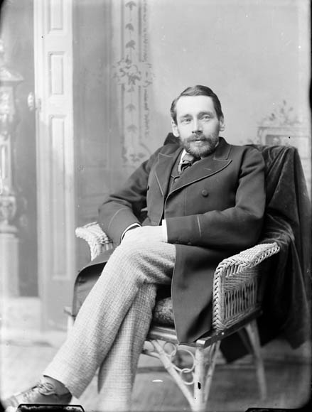
The above text is taken from George Mercer Dawson’s 1881 Report on Exploration from Port Simpson on the Pacifica Coast to Edmonton on the Saskatchewan. George Dawson was a Nova Scotia-born geographer who conducted numerous expeditions for the Geological Survey of Canada, beginning in 1875 until his unexpected death in 1901.
It is important to understand Dawson’s work within the context and as a product of colonialism, reflecting Canada’s assertion over the western territory. It is clear from his writings that Dawson had a great interest in the Indigenous cultures he encountered, and likely established friendships with the men he hired as guides and liaisons. Yet Indigenous peoples are notably absent from the majority of Dawson’s maps and official reports. In his PhD dissertation, Jason William Grek Martin suggests that—like many Europeans at the time—Dawson subscribed to the ‘Vanishing Indian’ belief that Indigenous cultures would not survive post European arrival. Indeed, in his reports of the area surrounding Drift-Pile Camp, Dawson describes several Indigenous travel routes and trading hubs as “abandoned” or “forgotten.” By relegating Indigenous peoples to a rapidly-disappearing past, or by excluding Nations from maps entirely, Dawson and his contemporaries presented the western territory as vast, uninhabited and ready to be acquired by Canada.
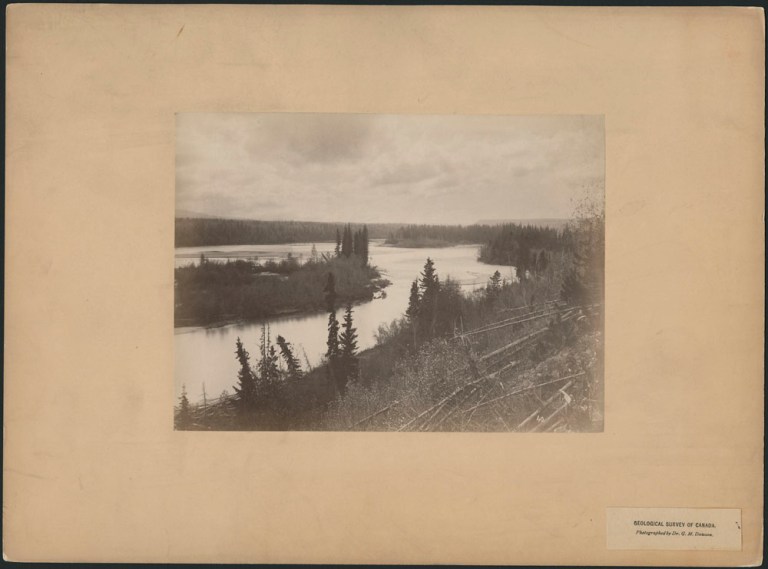
Dawson and his party spent three days in late September 1879 on the high banks of the Athabasca River, at a location he calls “Drift-Pile Camp,” west of present-day Whitecourt. In the journal, Dawson mentions a Cree guide named Antoine, and his son. Two additional Indigenous scouts traveled upstream and downstream of Dawson’s party, with the eventual goal of reaching Edmonton. Drift-Pile Camp is referenced multiple times in the journal; a sketch, photographs and rudimentary coordinates are even provided. Dawson makes no mention of an Indigenous presence on the land. Was this really the case?

Driftpile Cree Nation
Driftpile Cree Nation is a Treaty 8 First Nation with reserve lands on the south shore of Lesser Slave Lake. With approximately 800 on-reserve members today, Driftpile Cree Nation is a vibrant community that hosts an annual powwow attended by thousands. Karl Giroux is the Consultation Director for the Nation. When he started in the role in 2018, Karl quickly learned of his predecessors’ efforts to research possible connections between the Nation and the camp of the same name referenced in Dawson’s journal.
Today, Driftpile Cree Nation is one of five contemporary First Nations with reserve land bordering Lesser Slave Lake. However, at the time George Dawson surveyed the Athabasca and McLeod rivers, these communities were all part of one collective, known sometimes as Kinosayoo’s Band or the Lesser Slave Lake Band. When Treaty 8 was signed in 1899 south of present-day Grouard, Kinosayoo was selected as Chief and directed the surveying of two reserves, including one at Driftpile River.
Driftpile Cree Nation understands Drift-Pile Camp to be located within their traditional territory. According to recollections and oral tradition, Driftpile members would spend summers at Lesser Slave Lake and travel as far west as the mountains in the winter to hunt and trap. Despite cold temperatures, the Athabasca River never froze, making it a viable travel route year-round.
Dawson wrote: “From our starting point, Drift-Pile Camp, a few miles above the mouth of Marsh Head Creek, to the mouth of the McLeod River, the Athabasca valley probably averages two miles in width from rim to rim, and is from 300 to 400 feet in depth, though the banks become somewhat lower and retire further from the stream near its confluence with the McLeod.”
Can this location be found again?

Searching for Drift-Pile Camp
This was Karl’s and my first time at Drift-Pile Camp. Together, we continued the work of our predecessors, who conducted the first site visit to the area in 2010 after interest in George Dawson’s journal was initially piqued. Using Dawson’s coordinates and an analysis of air imagery, cross-referenced with the journal sketch, an approximate target location was identified. Nearly a decade later, despite leadership and staffing changes, the research and protection of Drift-Pile Camp remain a strong priority for the community. On this day, we are joined by Driftpile Elders Eugene Laboucan, George F. Giroux, Hank Giroux, Peter Okimaw, Duke Chalifoux and Nation staff member Victor Prinz and Archaeological Survey of Alberta regional archaeologist Todd Kristensen.
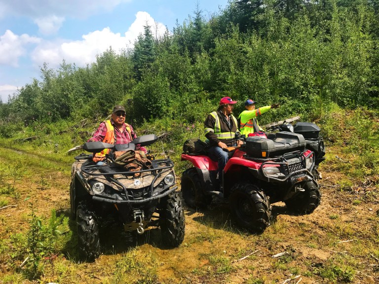
Accessing the camp location requires significant effort, and the extent of industrial disturbance on the landscape is impossible not to notice. We park our vehicles at a nearby well site and begin with a quad ride through a harvested cutblock. These trees were cut sometime in the last five years, and Driftpile Cree Nation is frustrated that forestry operations would be allowed in close proximity to a cultural landscape of high significance to the community.
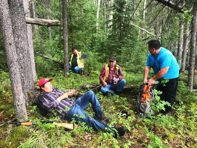
We enter the mixed boreal forest and make our way slowly down the steep slope leading to the Athabasca River, but not before Duke Chalifoux and George Giroux take note of what appear to be four or five tipi poles, resting against a tree along the ridge. The ground is densely vegetated and filled with deadfall. By the time we reach a terraced bank—marked by a contemporary lean-to that Driftpile members built in 2010 to serve as a landmark—everyone is ready for a rest.
We walk east and spot the first of approximately 30 culturally-modified trees (CMTs) that Driftpile Cree Nation has identified over the years. Hank Giroux was the first to locate the trees and takes pride in the fact he was able to do so without the aid of modern technology. The CMTs are girdled bark-stripped birches: horizontal, rectangular scars that span the entire circumference and in some locations reach higher than six feet up the tree. In the past—and today as continuing traditional practice—birch bark was peeled in large sheets, and used as material for containers, cradles, canoes and toboggans. The sap and pitch were used as both medicine and fire starter. Eugene Laboucan suspects the bark would have been stripped for canoe repairs; there are too many trees for the bark to only be used for moose calls. Could these trees have been used by Dawson and his party for the canoe-making efforts mentioned in his journal?

The understood location of Drift-Pile Camp is approximately 500 metres west of the lean-to, accessed by crossing an unnamed creek and following a series of game trails. Duke first suggested this area to be the location of the camp in 2011, based on both the landscape features of high archaeological potential (point terrace above the river) and the sketch and description of the camp location from Dawson’s journal. Through the trees, the muddied waters of the fast-moving Athabasca can be seen, as well as small islands—not unlike those appearing in the journal sketch. Driftpile members point to auspicious features on the landscape, including changes in vegetation. Others have said they smelled the scent of tanned hide in the air on previous site visits.
We have reached our destination. We sit down, eat a snack, and talk among ourselves—perhaps mere footsteps from where Antoine, George Dawson and the rest of their party did the same that late September in 1879.

The Future of Drift-Pile Camp
Tangible archaeological or historic evidence has not yet been able to confirm the exact location of Drift-Pile Camp. We cannot yet say for certain if this was the location where George Dawson and his team camped for three days while preparing their canoes to travel to Athabasca River. Regardless, this area is a significant cultural landscape for Driftpile Cree Nation and the community’s continued efforts to preserve it are admirable and have been recognized. Moreover, the act of experiencing the cultural landscape and Driftpile traditional territory together—sharing stories and enjoying each other’s company out on the land—can be considered an act of heritage preservation in and of itself.

When asked about the future of Drift-Pile Camp, Eugene told us: “I want to protect the trees. I want to make this area like a park, make it more accessible, for youth to come out and see how [early Indigenous Peoples] lived. We were here, and we are here.” With these efforts, Driftpile Cree Nation is reverting Dawson’s narrative of an uninhabited, untamed west, and reminding us all of the Indigenous peoples who occupied these lands long before the arrival of Europeans, and who continue to do so today. Similarly, Duke would like to see cabins constructed up on the ridge, to facilitate cultural camps and experiences for Indigenous youth. It is Duke’s hope that this could later become an Indigenous tourism experience and a new source of revenue and pride for the community.
Drift-Pile Camp has been afforded protections under the Historical Resources Act. This protection recognizes the significant efforts by Driftpile Cree Nation members to locate the site, as well as the Nation’s strong desire to preserve this special place for the education and enjoyment of future generations.
Thank you to Eugene, George, Hank, Peter, Duke, Karl and Victor for sharing their memories and knowledge with us. Hiy Hiy.
The Historic Resources Management Branch’s Aboriginal Heritage Section works with Indigenous communities to preserve and protect the cultural heritage sites that are an important part of Alberta’s heritage. To connect with the section, please email aboriginal.heritage@gov.ab.ca.
Sources:
Archaeology Branch, B.C. Ministry of Small Business, Tourism and Culture for the Resources Inventory Committee. (2001). Culturally modified trees of British Columbia: A handbook for the identification and recording of culturally modified trees. Province of British Columbia. Available here.
Dawson, George Mercer. 1881. Report on exploration from Port Simpson on the Pacifica Coast to Edmonton on the Saskatchewan. Geological Survey of Canada, Report of Progress, 1879-1880. Ottawa: Geological Survey of Canada.
Dictionary of Canadian Biography. Dawson, George Mercer. Available here.
Madill, Dennis F.K. 1986. Treaty Research Report: Treaty 8 (1899). Treaties and Historical Research Centre: Indian and Northern Affairs Canada. Available from https://www.rcaanc-cirnac.gc.ca/DAM/DAM-CIRNAC-RCAANC/DAM-TAG/STAGING/texte-text/tre8_1100100028810_eng.pdf.
Martin, Jason William Grek. 2009. Making settler space: George Dawson, the Geological Survey of Canada and the colonization of the Canadian West in the late 19th century (Doctorial dissertation, Queen’s University, Kingston, Canada). Available from https://qspace.library.queensu.ca/bitstream/handle/1974/5142/Grek-Martin_Jason_W_200909_PhD.pdf?sequence=1.
