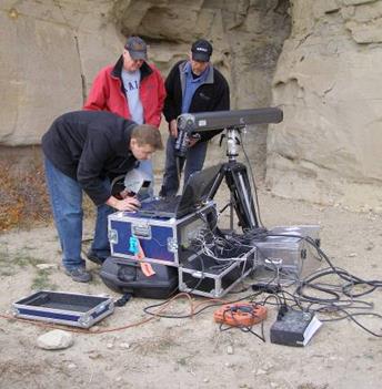
Have you ever discovered a projectile point, stone tool, ceramic, bone or other archaeological artifact? If so, we want to hear from you!
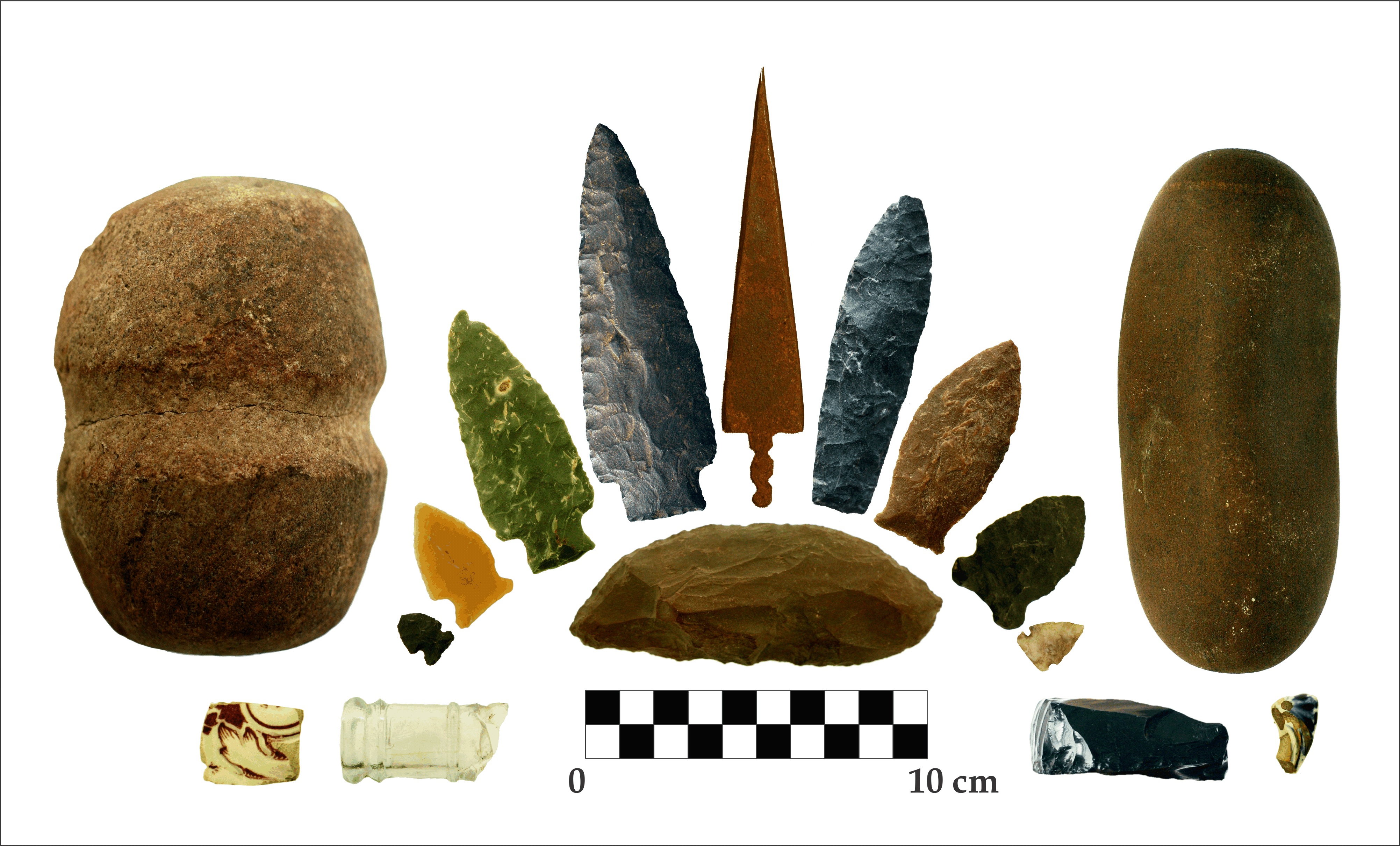
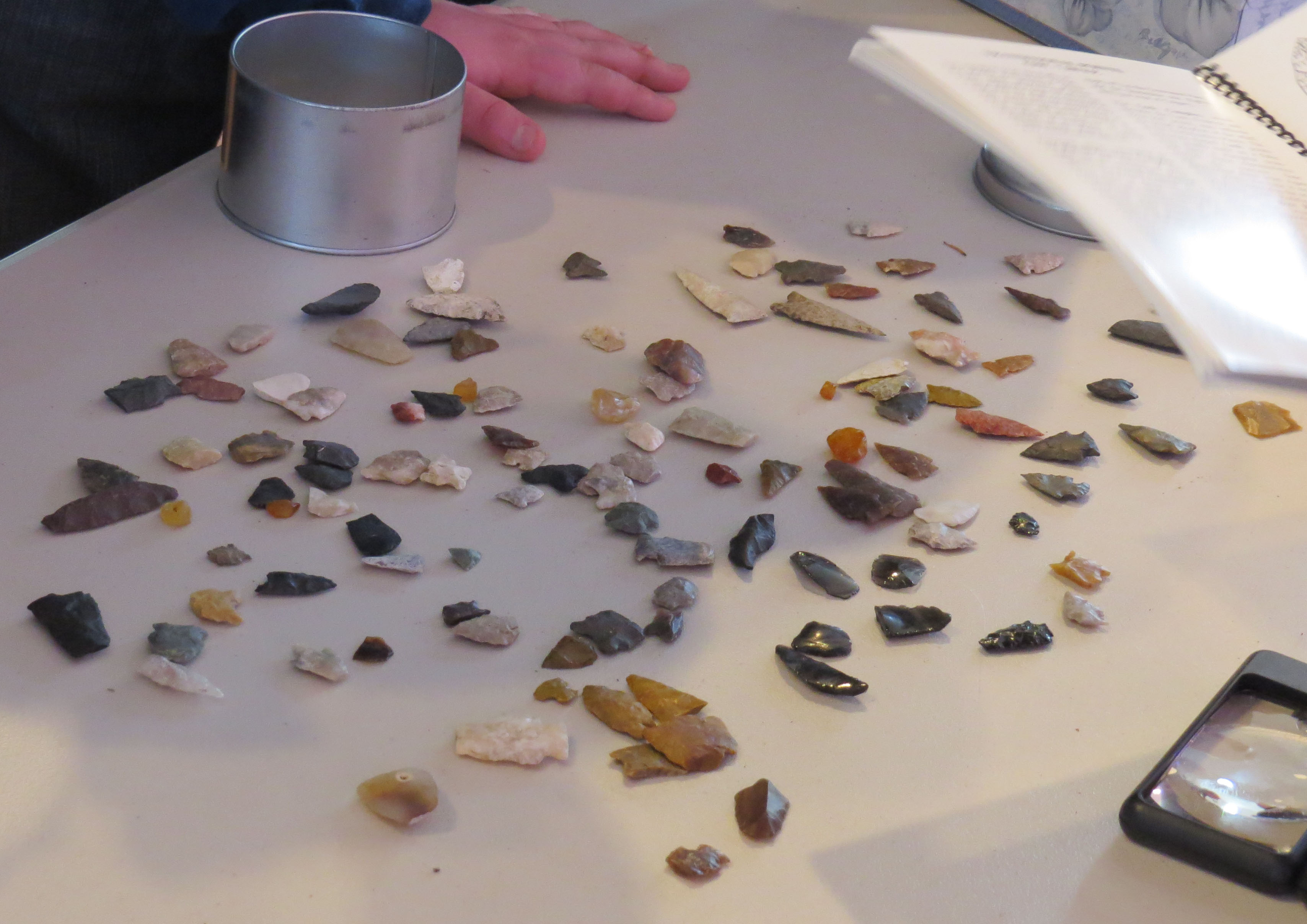
A variety of artifacts typically found in Alberta. Photo credit: Todd Kristensen.
Archaeological artifacts may be exposed by natural events (flooding, freeze/thaw cycles or tree throws) or human modification to a landscape (agriculture, recreation activities or development). As explained in a previous post, Alberta is Rich in Archaeology, archaeologists working in the province discover, or revisit, sites during the course of Historical Resource Impact Assessments. However, there are large stretches of the province that are not subject to Historical Resource Impact Assessments such as previously cultivated areas or areas that do not have development projects on them. This doesn’t mean there are not archaeology sites there. Often, people will discover archaeological artifacts and sites when they are out hiking, fishing, geocaching, working or cultivating their fields. This can include arrowheads or other stone tools, bones, ceramics or tipi rings and other stone features. So, what can people do when they make these discoveries? They can Report A Find!
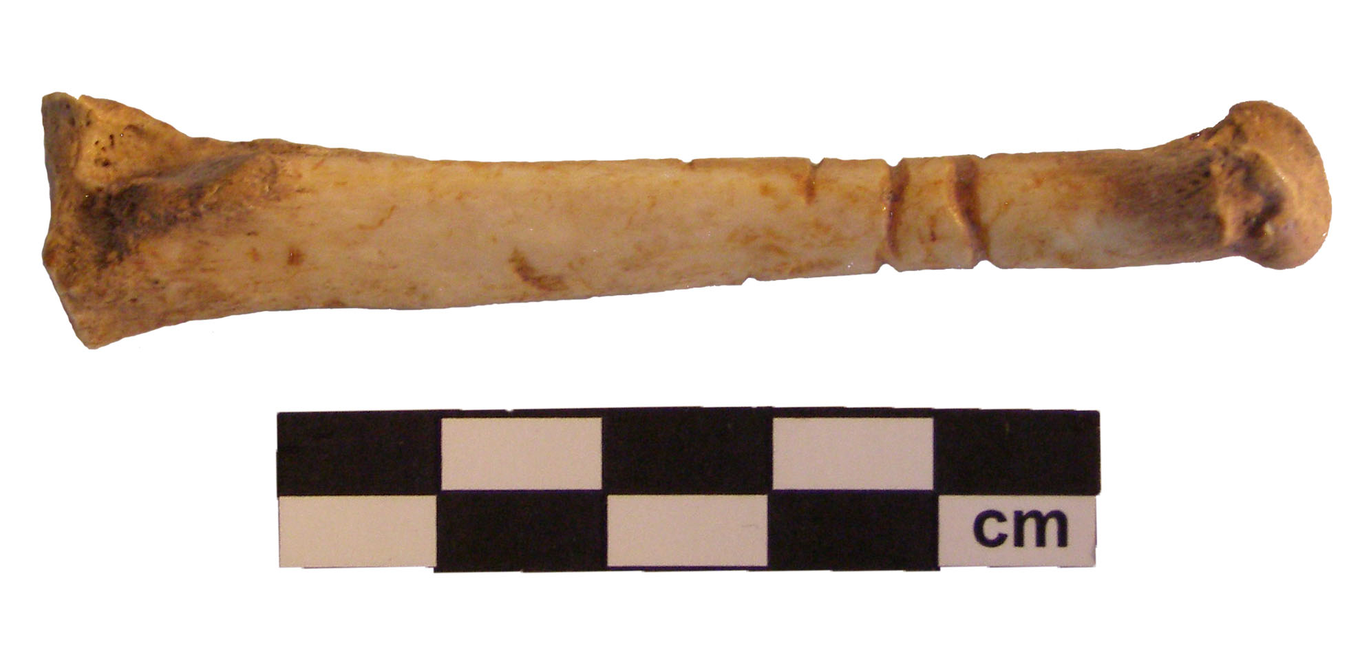
Bone artifact from a “Stones and Bones” event in Coaldale. Photo credit: Royal Alberta Museum.
The Archaeological Survey has set up a webpage where people can report their discoveries. You can get an expert opinion on your find and, who knows, possibly be credited with recording a new archaeological site! Recording this information is a big step in helping to preserve and protect Alberta’s historical resources. But, please remember that if you observe an artifact in your travels, the best practice is to leave it where you found it. Archaeological sites are protected under Alberta’s Historic Resources Act, regardless of where they were found. Removing an artifact from its original context disrupts the integrity of the site and may hinder efforts to further understand the significance of the object. You just need to provide us with a photo of your find and the location it was found, either by providing geographic coordinates or plotting the location on a map. Your find will be reported to staff at the Archaeological Survey and they will follow up with you and possibly ask for additional information. Staff will confirm if the site is already known or if the find warrants a new site designation!
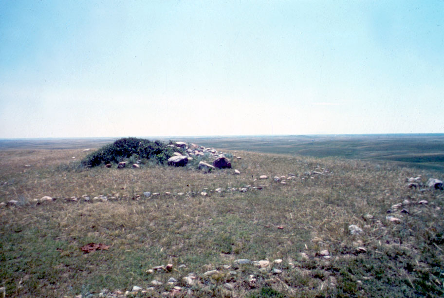
Medicine Wheel with outer rings and a central cairn. Photo credit: Royal Alberta Museum.
Reporting finds can provide valuable information that helps the staff at the Archaeological Survey manage, protect and preserve archaeological resources in Alberta. We can’t wait to hear about your discoveries!
Written by: Courtney Lakevold, Archaeological Information Coordinator.
Alberta Culture and Tourism manages the Online Permitting and Clearance (OPaC) system, which has two main purposes: to discover if a historic resource will be impacted by a proposed development and to regulate the approval of archaeological and palaeontological excavation permits.
Developers and municipalities use OPaC as a tool to determine if a proposed development may affect a historic resource. Before beginning development, the project’s proponent submits an application for approval to proceed. The application is reviewed by the Historic Resources Management Branch to determine if the proposed development has the potential to damage any historic resources, such as archaeological, palaeontological, historic or Aboriginal traditional use sites. The Branch reviews approximately 3,000 development applications each year!
Archaeologists and palaeontologists obtain permits through OPaC before proceeding with an excavation. Anyone who intends to excavate for the purpose of archaeological or palaeontological research must submit an application with the details of their project to the Historic Resources Management Branch for review. Permits are given out in order to regulate the amount of excavation activity that takes place in the province and to ensure that those who are excavating for archaeological and palaeontological purposes are qualified to do so. 500 applications for archaeological and palaeontological research permits are received per year by the Branch. The Archaeological and Palaeontological Research Permit Regulation has more information on the qualifications necessary to hold such permits and the conditions under which studies must take place.
Ten years ago, applications were managed the old fashioned, paper-based way and reviewing them was a much slower process. With the boom in the oil and gas industry, the workload increased substantially and this created the need for a more efficient permitting system. In 2009, the idea of OPaC was introduced as a semi-automated way to process applications. This was a welcome transition and has made the application procedure more convenient for developers who are seeking to conduct work on Alberta’s land as well as for the people managing the applications.
There are a number of advantages to the OPaC system:
It has brought a consistent approach to the process and ensures that applications and inquiries are addressed in a timely manner.
The online database stores information on the location of archaeological, palaeontological and historic resources as well as Aboriginal traditional use sites. This data is used to build a cumulative sense of the resources and developments that are on Alberta’s landscape. This way, strategic measures can be taken to protect the resources.
It serves as a starting point to capture heritage data and assists in identifying issues in advance to better protect Alberta’s historic resources.
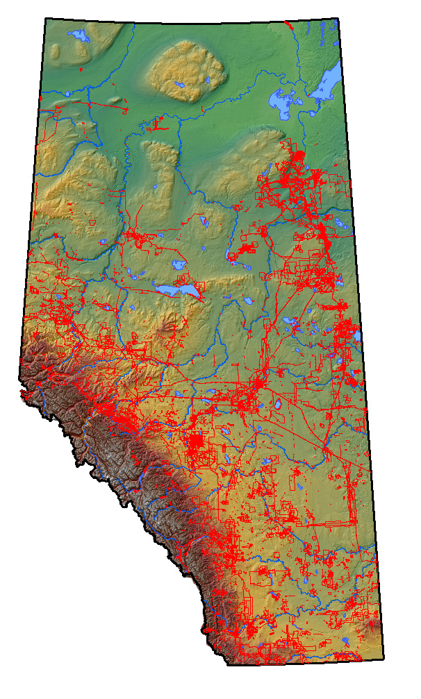
With the help of the Geographic Information System (GIS), we can map the locations of proposed developments and historic resources to help identify and minimize potential conflicts.
GIS map showing the locations of development projects that have been processed through OPaC.
OPaC has brought efficiency to the application process, but a wider significance lies in the fact that it supports a regulatory process that helps to discover historic resources that may otherwise go unnoticed and, therefore, unprotected – an important point, since the more we can preserve, the clearer picture we can create of Alberta’s past and this has immense benefits for future generations.
The Historic Resources Management Branch is responsible for the preservation and protection of Alberta’s historic resources as mandated by the Historical Resources Act. OPaC is a key tool in fulfilling this responsibility, as it allows experts the ability to easily and quickly determine the level of impact that could potentially threaten Alberta’s historic resources. Alberta Culture is committed to the preservation and protection of Alberta’s historic resources and this system helps to ensure that the opportunity for enhancing that knowledge is not lost.
For more information on OPaC, please refer to our website.
Written by: Erin Hoar, Historic Resources Management Branch Officer, with special thanks to the OPaC team for their assistance.
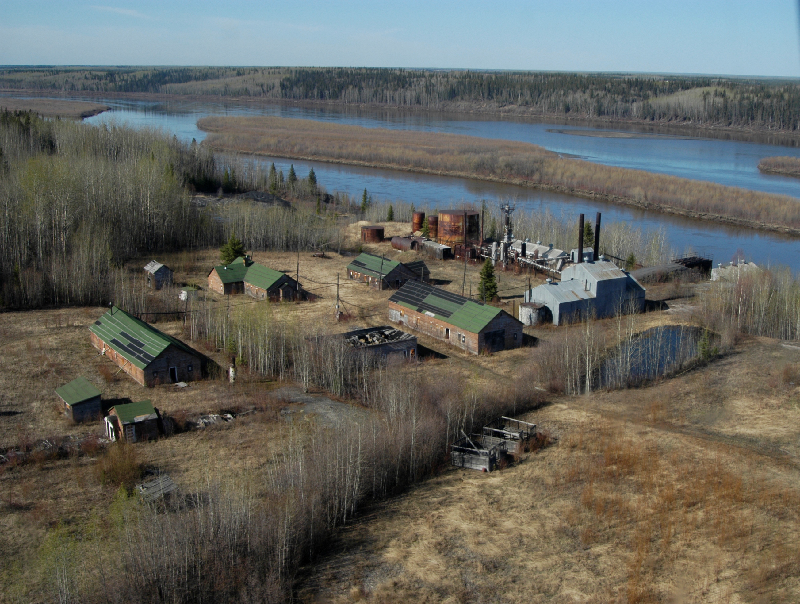
In the spring of 2010, I took award-winning poet David Martin on a tour of Bitumount, an oil sands separation plant located on the Athabasca River north of Fort McMurray, Alberta. This provincially-designated historic site was founded in the late 1920s by Robert Fitzsimmons, a man whose unique sense of entrepreneurship and ability to stir convention made him one of the most colourful characters in oil sands history.
Bitumount Site Provincial Historic Resource, near Fort McMurray (Historic Resources Management Branch, July 2005).
Fitzsimmons’ story is an important element of David’s recent work, a collection of poems that examines the oil sands milieu from historical, archaeological and even geological perspectives. His compositions have been published in literary journals such as The Malahat Review, Grain magazine, The Fiddlehead and CV2, and he won the 2014 CBC Poetry prize for his oil sands themed poem “Tar Swan.” Fitzsimmons and the oil sands archaeological record are also featured in “Ballad of RCF,” a song from Stone Boat, the second album from David’s pop rock group The Fragments.
Our visit to Bitumount, and the pre-contact period archaeological excavations nearby, provided David with insight into the oil sands past that he could not gain by other means. This illustrates an element of historic resource preservation that is rarely documented: literary inspiration. I spoke to David about the trip, oil sands as poetry and how he incorporates archaeological information into his work.
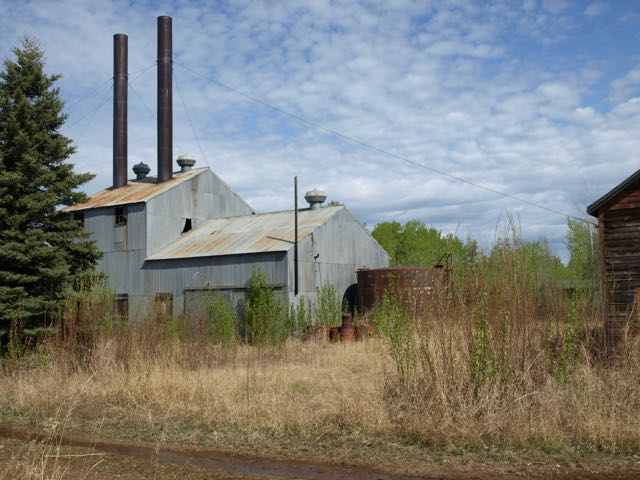
The powerhouse at Bitumount (photo by David Martin).
What drew you to write about Robert Fitzsimmons and Bitumount?
I felt that the Fitzsimmons story offered me a smaller, more manageable way to write about the oil sands, rather than to focus on current industrial operations. Fitzsimmons was undoubtedly a very charismatic person, so naturally I was drawn to his experiences. I read about him in several history books, as well as in his personal letters and a small pamphlet that he published; although I quickly learned that he was not always the most reliable source in discussing his own work.
How did the trip to Bitumount and the surrounding area influence your writing?
I had done a great deal of research before the trip, such as reading books and examining documents in the Provincial Archives. However, being at the actual site offered me many details that I would never have discovered in books or photographs. I was able to incorporate these small details into the poems, which I believe helps to give my work a sense of verisimilitude.
I was keen to visit Bitumount because it presented a tangible way to understand the development of the oil sands, and it was fascinating to see it in the context of the surrounding environment: an abandoned industrial site hidden within the boreal forest. As well, there are different phases of history within this single space, such as the original Fitzsimmons plant, the larger provincial pilot plant that was later built and the modern debris left by people who have passed through the area.
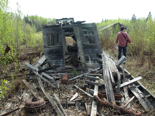
Remains of a small barge at Bitumount (photo by David Martin).
What site feature or landscape feature struck you the most?
I had previously seen a brief archival film of Fitzsimmons piloting his boat, The Golden Slipper, and it was an amazing moment for me to see the same boat tucked beneath a small A-frame shelter. The boat is slowly falling apart but the name is still visible, and this was a powerful way for me to connect the history I had been learning about with a physical object in front of me. It’s always inspiring when history appears in a concrete form.
It was also interesting, and a bit eerie, to see handwritten words at the entrance to one of the buildings, supposedly from Ernie Eakins, a long time caretaker of the Bitumount site. In neat blue cursive it reads: “You will never never make it home again if I catch you in this lab.” He probably wrote this note to scare off trespassers, but it was unsettling to read it in the abandoned building.
The incorporation of boreal forest archaeology in your poems is certainly unconventional. What role does archaeology play in your compositions? What source information did you draw upon?
The archaeological work in the Athabasca area was important for my poems because it reveals a historical context that extends back thousands of years. Just as important, though, was my learning about excavations of more recent sites, such as Fitzsimmons’ early drilling camp. The archeological dig serves as a narrative frame for my work; it demonstrates a way of literally uncovering history.
Another archaeological idea that is central to my work is debitage: making inferences about the past based on debris and fragments. Debitage analysis seems like a fitting analogy for what my poems are aiming for — building a connection to the past by using the imagination and the fragments that have survived from that time.
Will you continue to mine historical information for future compositions?
Currently I’m researching about lake sediment sampling for some poems. I’m drawn to the idea that a core sample can contain a great deal of information about what the environment was like thousands of years ago.
Written by: Robin Woywitka, Cultural Land Use Analyst, and a special thanks to David Martin for his participation.
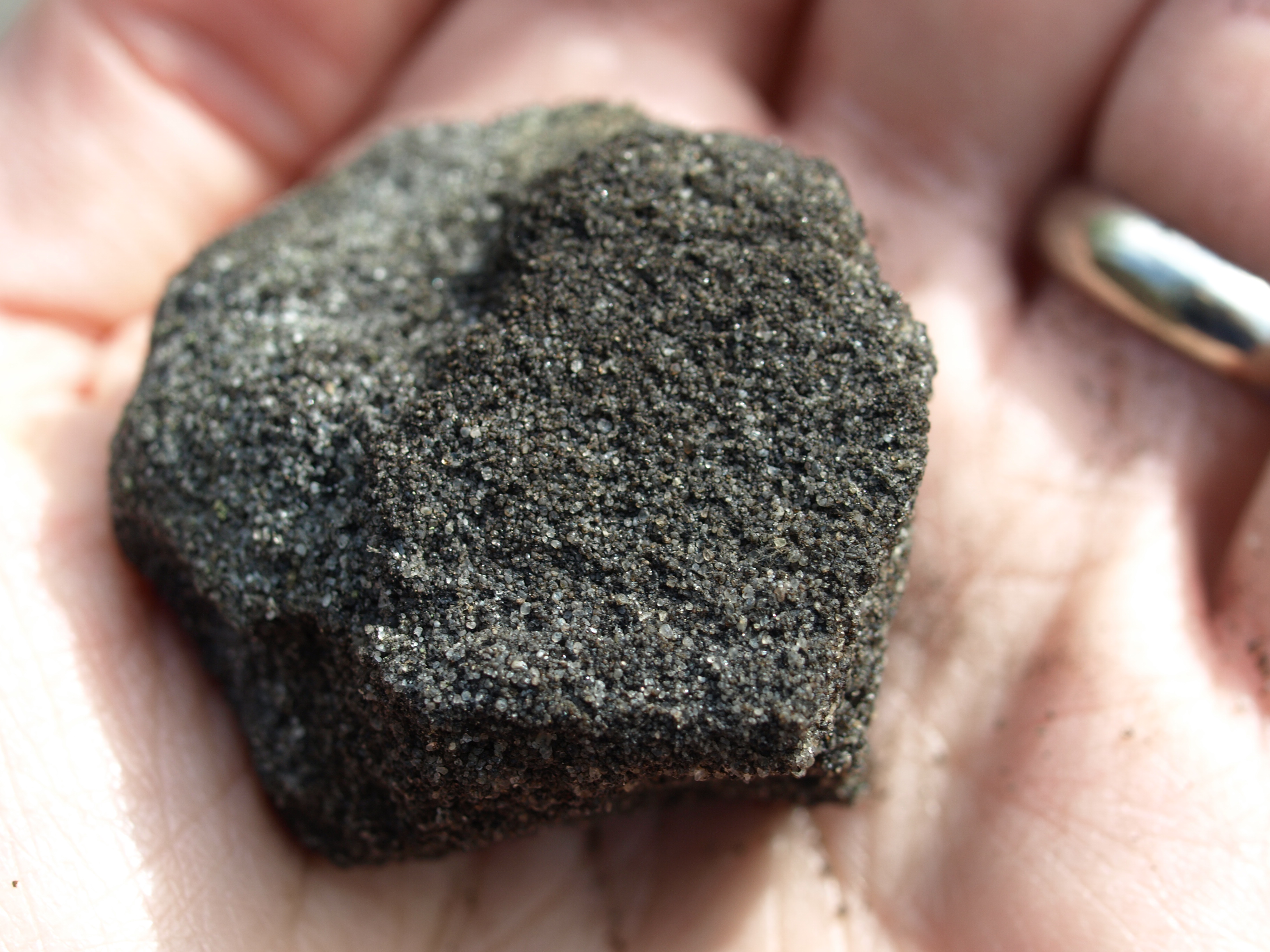
David holding a piece of bitumen (photo by David Martin).
Below is an excerpt from David Martin’s oil sands poetry manuscript:
The road, paved with bitu-phalt,
rutted, dimpled, summer-soft:
a stubborn swipe between
Fitzsimmons and Government.
Frogs draw in counterpoint
behind the boiler house.
Across the river, the Horizon Project,
a mouth-brooding grandnephew,
punctures its dull tonic
with bleats of backfiring cannons –
Where do you stand?
Where do you stand?
The boat is slack, leaves
and moss rising, no one to bail.
*
South: other minds left behind
a beached steam engine, fridge
shamed in the woods, wind-hewn
garage, stalagmite-filled pump house,
and clutches of tanks and tubs –
all mute actors in a government-funded
play that closed on opening night.
Behind the scrum: a muskeg’s frame
freed of its burden.
Topographic hills relent; a drop
of bitumen syrup galls the whorls,
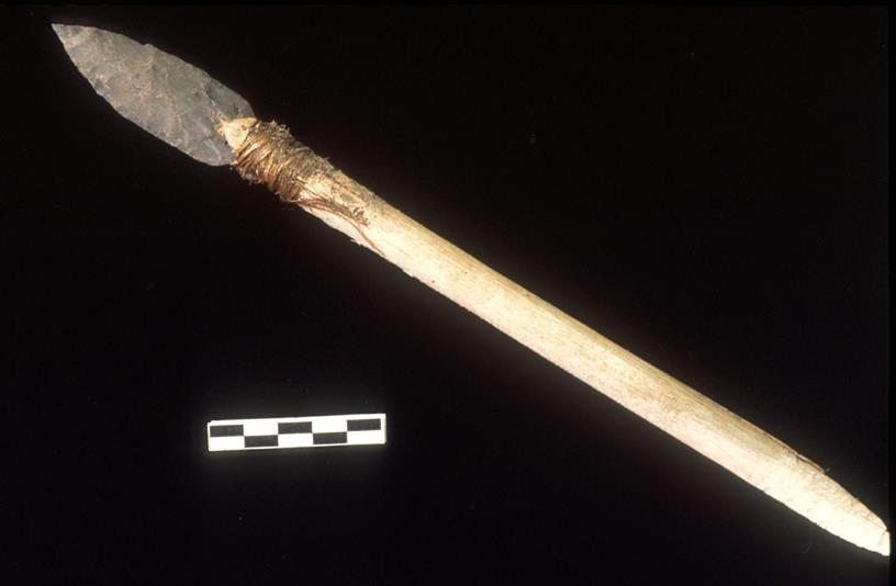
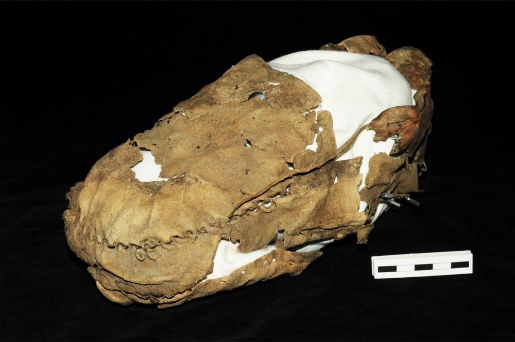
Recent archaeological research from Alaska to Yellowstone has revealed rare and delicate tools preserved in high altitude ice that tell of a deep human history in some of the most remote alpine habitats on the continent. These artifacts were lost by ancient hunters of alpine animals (like caribou and sheep) and had been encased in a barrier of ice that warming temperatures have recently unlocked. A race is now on to find frozen relics from the past before they, and the icy archives that house them, disappear.
This stone dart is over 4000 years old and is preserved in its original wooden shaft (courtesy of the Government of Yukon).
The story of prehistoric alpine hunters in North America owes its existence to Yukon biologists who discovered an odd piece of wood above the treeline. The find was reported to local archaeologists who realized that it was a wooden tool lost on the ice thousands of years ago. First Nations across the North still remember stories of traditional life in the alpine, but until that lucky Yukon find, archaeologists didn’t expect that much physical evidence of old activities could be preserved in the harsh high altitude conditions. It is very rare to find wooden tools that are thousands of years old, so the artifact triggered a series of research programs in the North.
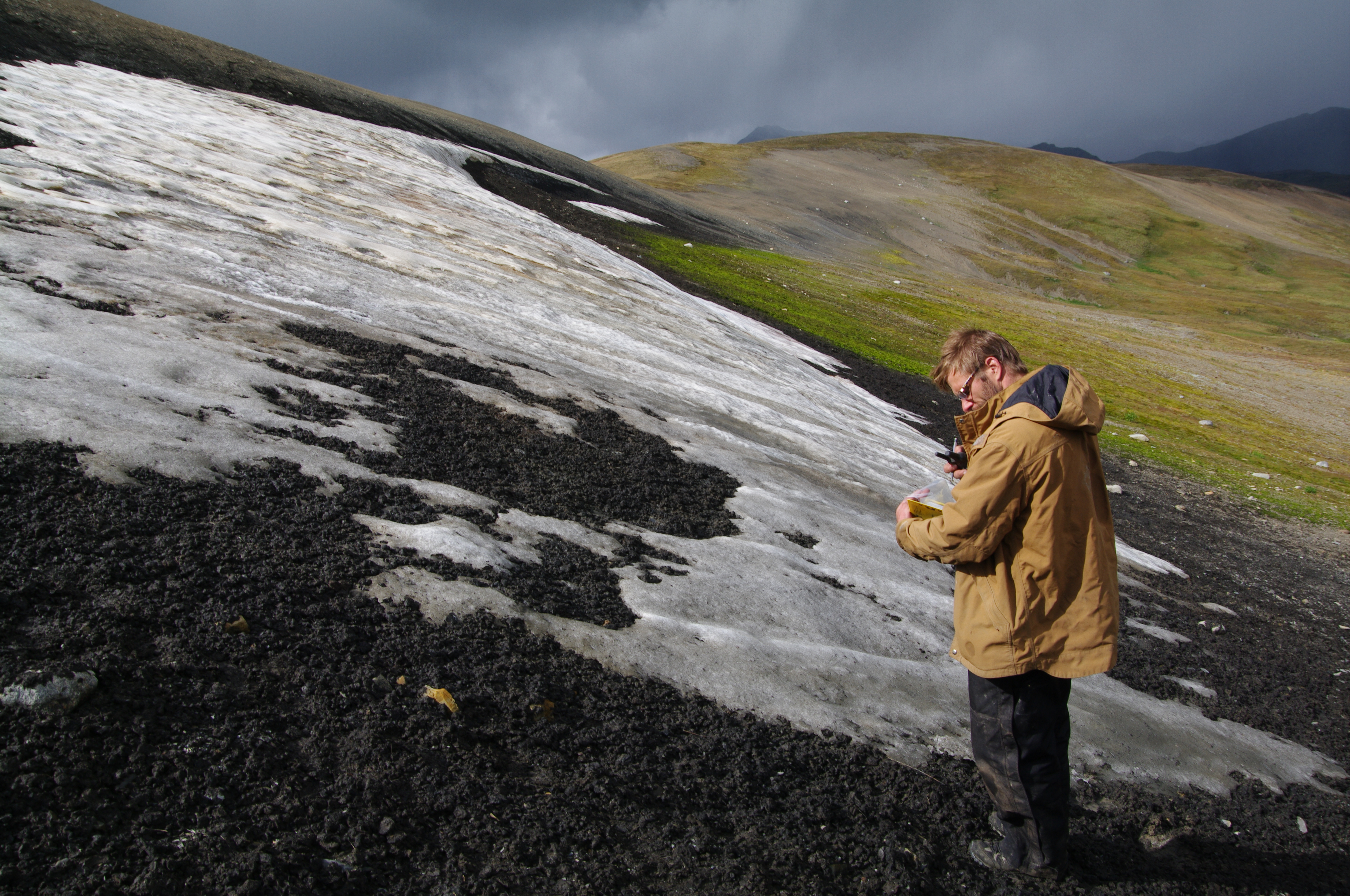
An archaeologist (Todd Kristensen) surveying a melting ice patch for artifacts (courtesy of Mike Donnelly).
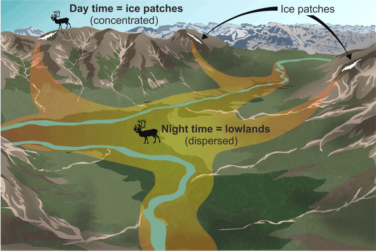
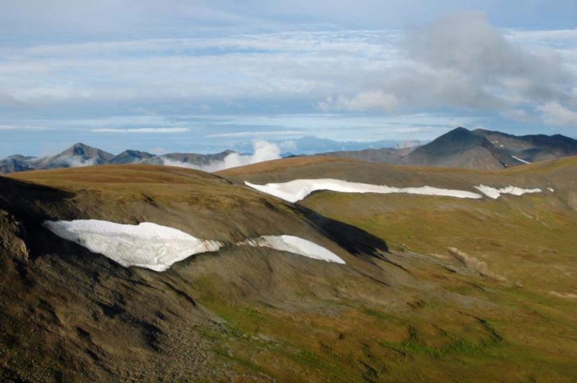
On a daily basis, caribou migrate upslope to colder heights during the hottest time of day only to return to the valleys at night. Alpine ice features provide animals relief from insects and hot temperatures. This long-lived habit of ice patch use makes these animals predictable. And so, as long as caribou and other animals have been gathering at ice patches in the North (for over 9000 years), people armed with sturdy moccasins and stone-tipped weapons have followed them.
Caribou gather on the upland ice features to stay cool in the midday heat (Todd Kristensen).
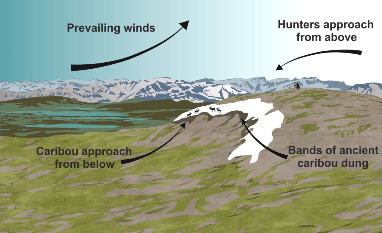
The perfect ice patch borders a round top that enabled hunters to lurk from above undetected (Todd Kristensen).
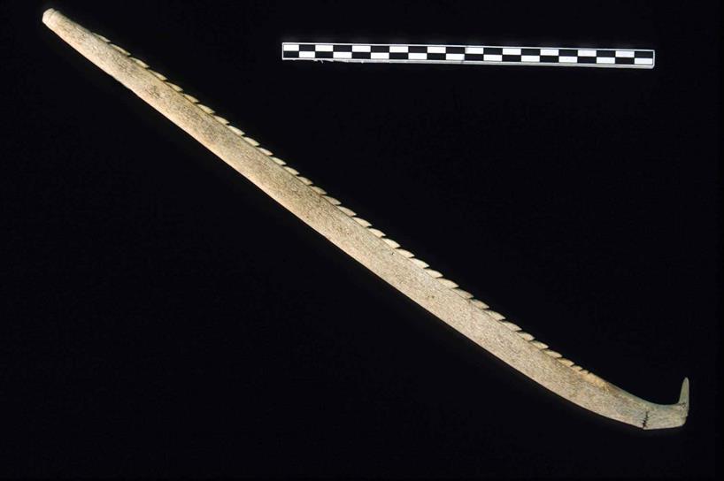
Archaeologists have found remnants of prehistoric hunting trips including possible broken spear shafts near Jasper, arrows, bows, darts, and an excellently preserved 1400 year old Yukon moccasin. Some arrows even retain the feathers that were tied to their shafts, which helped create drag that kept the arrows flying straight. (This is called ‘fletching’ and is the origin of the common European surname ‘Fletcher’. Arrowmaker is also a common First Nations family name for this reason.)
This moccasin held the foot of an alpine climber over a thousand years ago (courtesy of the Government of Yukon).Modern science is pin-pointing the materials used in ancient weapons (Todd Kristensen).
Archaeologists in N.W.T. have also found a snare in an alpine ice patch that was used to capture ground squirrels, the skins of which were stitched together to form beautiful robes. Based on First Nations traditional knowledge, up to 200 snares were set in a single alpine area and this could produce enough food to last for months. Add to this the supply of caribou, sheep, ptarmigan, and berries, and alpine life from late summer to early fall was good.
This barbed lance is a carved piece of antler from a Yukon ice patch (courtesy of the Government of Yukon).
Ice patches that lasted for over four millennia have vanished in the last 50 years and scientists are monitoring the implications for alpine ecology. While the causes of ice retreat are debated, the impact on the archaeological record is clear. Melting ice has unlocked a story of prehistoric hunting but at the same time, it has exposed those very clues of the ancient past to destructive high altitude weather. A book is opening and quickly closing and much remains to be learned before the fragile alpine artifacts decompose. If modern climbers find old bones, wood, or a potential artifact, please leave them in place and contact the authors with some photographs or map coordinates so we can continue to learn about the deep past of life in the alpine.
Ice patches in the North West Territories. (Tom Andrews, Government of N.W.T.).
A full version of this article appeared in the October issue of Alberta Outdoorsmen.
Written by: Todd Kristensen (Northern Archaeologist, Alberta’s Archaeological Survey); Tom Andrews (Territorial Archaeologist, Prince of Wales Northern Heritage Centre;, and Darryl Bereziuk (Director, Alberta’s Archaeological Survey)
Distribution of archaeology sites in Alberta, December 2014.
An archaeological resource in Alberta is defined as “a work of humans that is of value for its prehistoric, historic, cultural or scientific significance” and is protected under the Historical Resources Act. Sites are classed into two major groups: prehistoric and historic. Over 80% of the sites in the province are prehistoric (which predate the arrival of Europeans); just over 10% are historic (postdating European arrival); and the rest are a mix of both prehistoric and historic, contemporary, indigenous historic (such as Metis sites), and natural sites. Some of the most common prehistoric sites are campsites; stone features; animal kill sites; processing sites; rock art sites and ceremonial sites, such as medicine wheels and cairns. Historic sites include trading posts, police posts, early settlements, homesteads, and industrial sites.
Some of the oldest archaeological sites in Alberta date to as early as 13,000-8,000 years ago or what is known as the Palaeoindian Period. Prior to ~13,000 years ago what is now Alberta was covered by massive ice sheets that rendered the landscape uninhabitable. Shortly after the retreat of the ice sheets, however, animals and then people began moving into the area. At a site called Wally’s Beach in southern Alberta, archaeologists have recorded mammoth, camel and horse tracks. Not only that, they have discovered direct evidence of humans hunting these animals! Since then, what is now Alberta has been continuously occupied by numerous cultural groups, whose remnants we find in the form of discarded stone tools, butchered animal bones, hearths, broken pottery, buried palisade walls from forts and various other artifacts and features.
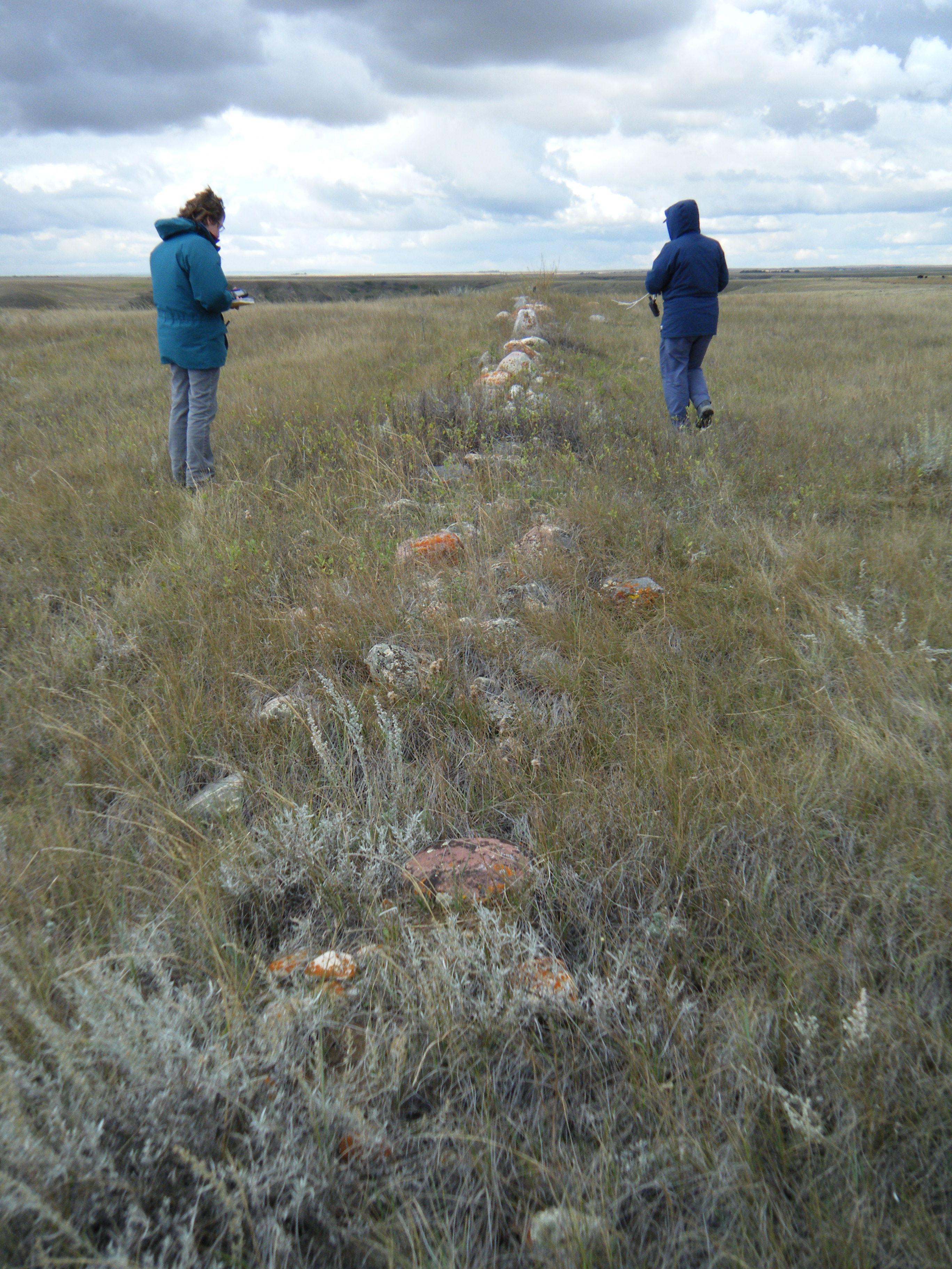
A historic fenceline at Writing-On-Stone Provincial Park being recorded by Alberta Culture & Tourism staff, October 2014. (Photo courtesy of Wendy Unfreed, Plains Archaeologist)
These days the majority of new archaeological sites in Alberta are recorded by historic resource management consultants. Consulting companies are hired by developers in the province to carry out Historical Resource Impact Assessments, which involve the survey and testing of areas that will be affected by a proposed development for the potential or presence of archaeological sites. If a consultant deems an area to be high potential (judged by factors such as landforms, proximity to water bodies, and proximity to known sites, among other things) he or she will conduct surface inspection and possibly shovel testing (digging a hole about 40 cm by 40 cm in size) to search for archaeological artifacts or features.
If results are positive, the information is submitted to the Archaeological Survey and a unique identifier, called a Borden number, is assigned to the site. The Archaeological Survey can then offer protection and management strategies for these sites. This could involve requirements for complete avoidance or excavation of the site prior to development. Archaeological site information is stored in the Alberta Archaeological Sites Inventory, an important resource for historic resource consultants and other researchers. Artifacts recovered from archaeological sites are stored at the Royal Alberta Museum where they are made accessible for research or put on display in one of their exhibits.
Alberta Culture and Tourism staff members Robin Woywitka (Cultural Land Use Analyst) and Todd Kristensen (Northern Archaeologist) recording stratigraphy at an excavated site in the Fort McMurray region, October 2013. (Photo courtesy of Robin Woywitka)
Alberta’s archaeology may not be as visible as in other parts of the world, but we really do have a rich heritage and an abundance of archaeological resources — we just have to work a little harder to find them. It’s incredible what we can learn when we start digging into our past!
Tell us, what’s your favourite archaeology site in Alberta?
Written by: Courtney Lakevold, Archaeological Information Coordinator.
The Archaeological Society of Alberta, incorporated in 1975, is an amateur organization committed to promoting, protecting and preserving Alberta’s heritage. The Society is one of five provincial heritage organizations that receive annual funding from the Alberta Historical Resources Foundation. The Society is currently made up of over 400 members, organised into six centres: Strathcona (Edmonton and area), Bodo, Red Deer, Calgary, Lethbridge and Southeastern (Medicine Hat). Membership in the Society is open to anyone with an interest in archaeology and it provides great opportunities for people of all ages to get involved in actively experiencing, promoting and protecting Alberta’s archaeological resources!
Artifacts brought into a “Stones and Bones” event hosted by the Lethbridge chapter of the ASA, March 2014. Photo courtesy of John Easton.
The Society facilitates public outreach programs and supports archaeological research across Alberta. Its programs include Speaker Series, workshops, fieldtrips, “Stones and Bones” events and an annual conference and general meeting that consists of a full day of speakers, a poster session and a day long fieldtrip. Professionals from the Archaeological Survey of the Historic Resources Management Branch often assist with, and participate in, Society events.
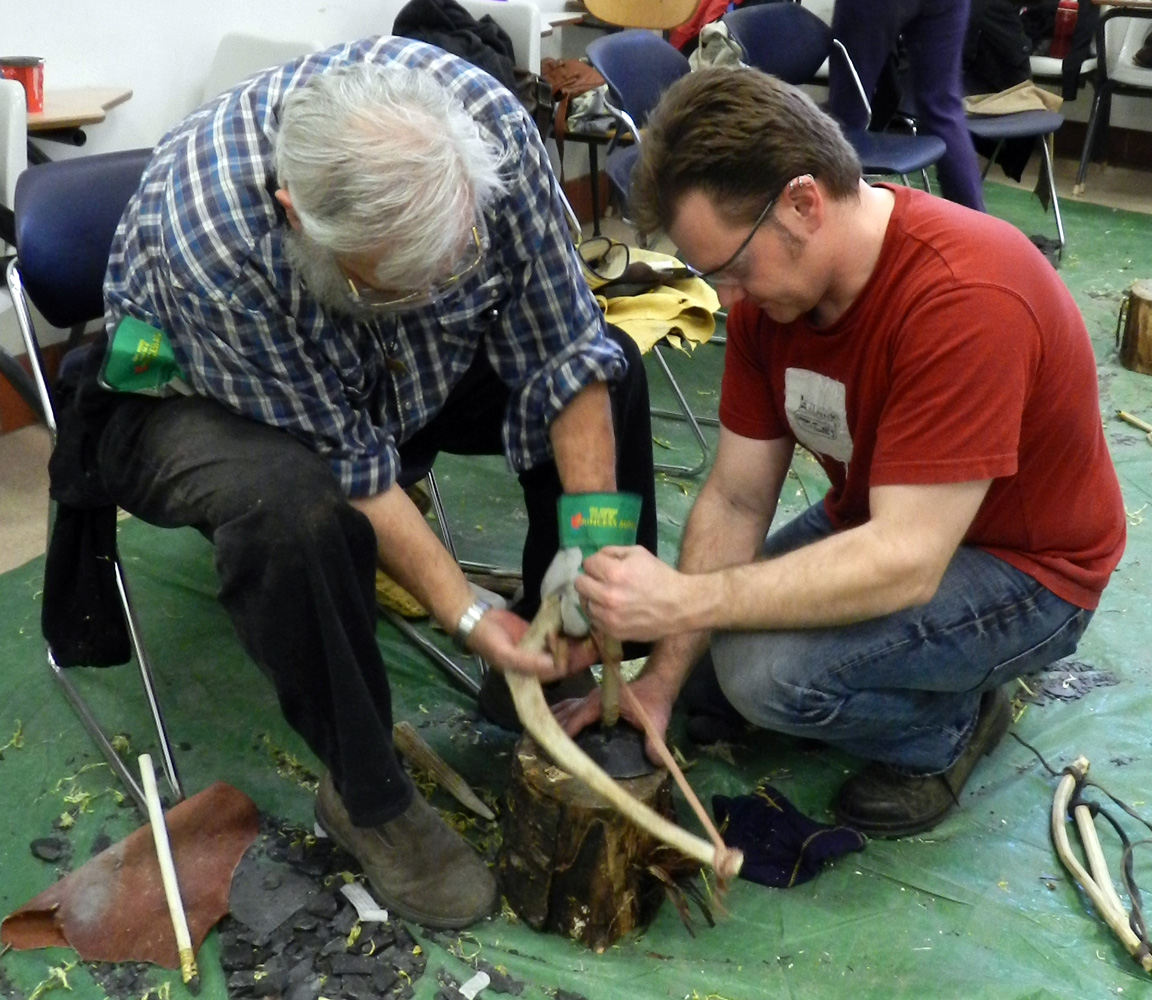
Members of the Strathcona society making their own stone tools at the March 2014 flintknapping workshop. Photo courtesy of Kurtis Blaikie-Birkigt.
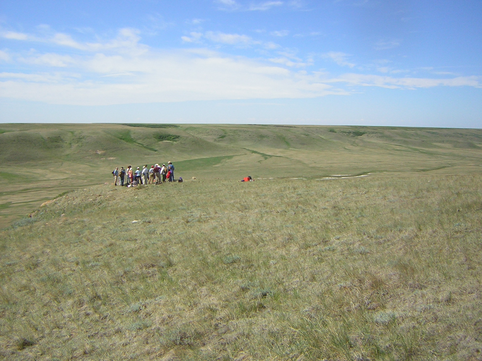
Speaker Series takes place from fall to spring and highlight Alberta archaeology through a monthly talk given by a professional archaeologist. The Strathcona centre is currently collaborating with the Edmonton Telus World of Science by offering the Speaker Series in conjunction with the Indiana Jones exhibit! Recent workshops have included flintknapping, artifact casting, historic artifact identification and artifact illustration. These workshops are day long or weekend events that teach people traditional and archaeological skills. The flintknapping workshop is one of the most popular events. Expert flintknappers from across the province and country teach members how to make their own stone tools using traditional methods of striking two rocks together and using antler tines to refine the shape of the tool and its edges. Nothing is more satisfying than being able to craft your own projectile point! “Stones and Bones” events provide a venue where avocational archaeologists, collectors, and the public can bring their artifacts in to be identified by professionals. This often results in valuable archaeological resources being revealed that enhance the archaeological record of the province. Fieldtrips to all types of sites including medicine wheels, effigies, bison jumps and pounds, and ceremonial sites allow an opportunity for Society members to visit archaeological sites and sometimes witness an active excavation.
Members of the Southeastern centre on a field trip to an effigy site in southern Alberta. Photo courtesy of Janice Andreas.
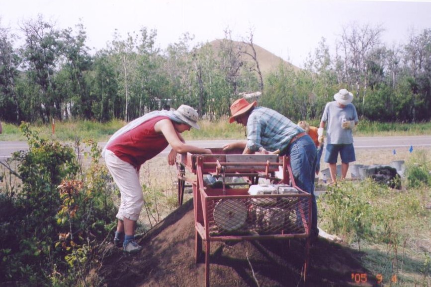
In addition to these programs, the Society provides funding and volunteer assistance to research projects undertaken by centres, educational institutions or individual members that enhance the knowledge and protection of Alberta’s historic resources. This includes archival research, excavation, or the survey of archaeological sites. Recent research this grant program has supported includes mapping of the Glenbow Town and Quarry site by the Calgary Centre, ongoing excavation at a bison kill site in Bodo and a survey of the Forks region in southeastern Alberta by Society members. All of this research has incorporated public participation by welcoming members to lend a helping hand.
Society members volunteering at an active archaeological excavation. Photo courtesy of Janice Andreas.
In addition to hands-on activities, the Archaeological Society of Alberta produces several archaeological publications. The Alberta Archaeological Review, published bi-annually since 1977, provides news of the Society’s activities and a forum for the presentation of archaeological research in Alberta. The Society also publishes archaeological reports and papers and has produced several versions of the popular book “Record in Stone: Familiar Projectile Points from Alberta” which outlines projectile point typology of the province.
Support from the Alberta Historical Resources Foundation makes it possible for organizations like this to carry out their mandates and create new initiatives to engage the public and make our province’s culture and heritage accessible to everyone! The foundation receives money from the Alberta Lottery Fund that is used to provide financial and technical assistance to community based heritage projects including several Provincial Heritage Organizations, like the Archaeological Society of Alberta, that deliver programs and services that document, preserve and present the province’s heritage.
Writing-on-Stone Provincial Park is nestled into the winding valleys and coulees along Milk River in Southern Alberta. Painted and carved on its fragile sandstone walls are one of the largest collections of rock art in North America. Appropriately named, Writing-on-Stone is a rocky canvas of ancient and historic art that spans many centuries.
To increase awareness of this unique piece of the past and to encourage the preservation of sensitive historic resources, a collaborative team of the Historic Resources Management Branch, the Royal Alberta Museum, and the University of Alberta initiated the Heritage Art Series project. The goal is to create artwork, like the piece depicted above, that captivates the public in order to encourage the appreciation and protection of Alberta’s past.
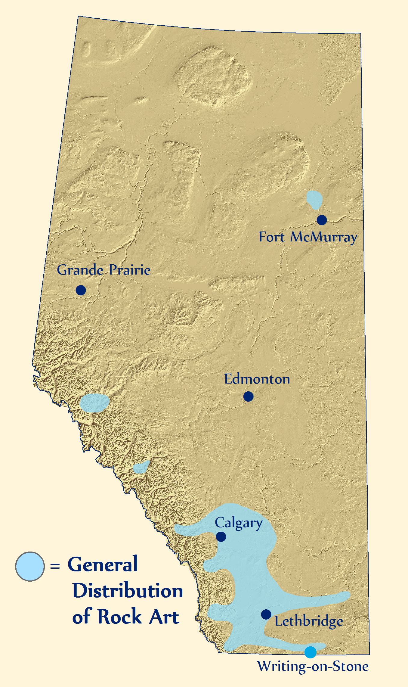
Rock Art in Alberta
Alberta’s rock art includes pictographs (paintings), petroglyphs (engravings), carved boulders, and effigies (rocks arranged to form shapes). Art that was applied to rock walls has a variety of functions and there are six major types in Alberta.
This map depicts the general extent of recorded First Nations rock art in Alberta.
‘En Toto Pecked’ involves figures that were entirely pecked out of the rock wall and this tradition of art appears in Alberta from 2500-1500 years ago. It is thought to have originated in Wyoming.
‘Vertical Series’ may be a type of rock art that acted as a communication system that related events and actors. It may be ideographic (like Egyptian hieroglyphs) with name glyphs like the Mayans of Central America.
‘Columbia Plateau’ refers to vision quest or hunting ritual art thought to be made by people originally from interior B.C. This style of rock art ranges from a few hundred to several thousand years old.
‘Foothills Abstract’ is a rock art style that consists of enigmatic shapes and motifs that may be the work of religious figures. Subjects include handprints, animals (and their tracks), and stylized humans.
‘Plains Biographical’ refers to rock art that documents events, important figures, or tallies of things acquired/exchanged by the Blackfoot and their ancestors.
Lastly, ‘Plains Ceremonial’ refers to spiritually important rock art that is still of great significance to modern Blackfoot Nations. Out of respect for the power of these and other rock art images to modern First Nations, photographs of the various styles of rock art are not included here.
The Milk River Valley Through Time
First Nations pursued buffalo herds in the Milk River region and view the valley as a sacred place where stories and dreams were recorded on the rock walls. The earliest Europeans included a mix of traders, coal miners, and Northwest Mounted Police, the early history of which is still recorded in modern place names.
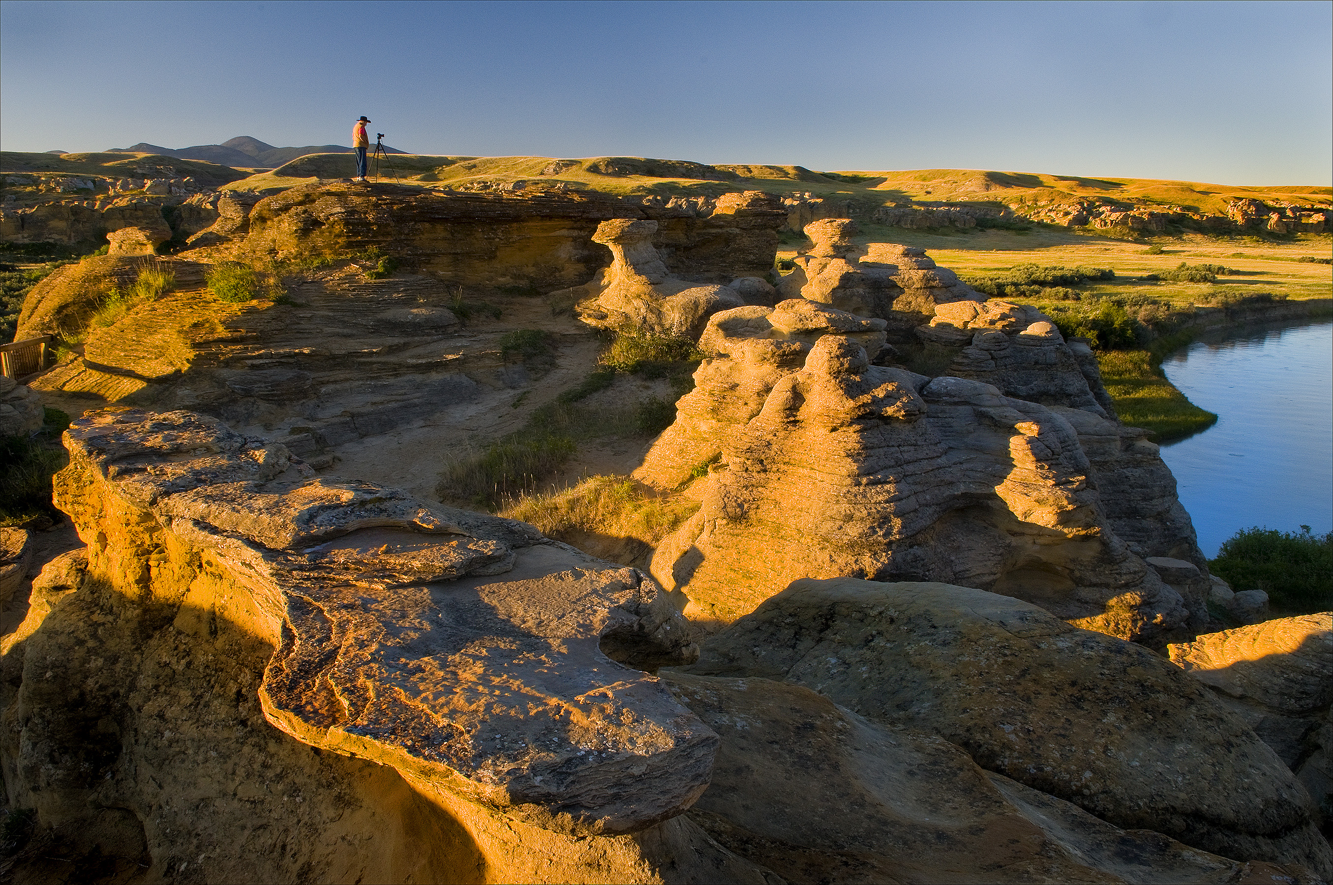
Cattle quickly replaced a vacancy left when buffalo were eliminated in the late 1800s. In addition to ranchers, new irrigation techniques and canals opened up the area to more intensive cultivation. Modern users of the Milk River landscape include farmers, Kainai First Nations, oil and gas operators, ranchers, and people in the tourism industry associated with Writing-on-Stone Provincial Park and National Historic Site (the photograph below is of the morning light on the park’s sandstone hoodoos, courtesy of Robert Berdan). Just as the uses of the Milk River region have changed in the past, they will continue to evolve in the future.
The above painting by Anne McCartney is a textured narrative of landscape change in the Milk River Valley. The background is from an aerial photograph showing irrigated fields creeping to the valley’s edge. At lower right is a looming sandstone cliff that has witnessed a steady flow of First Nations, traders, miners, explorers, and farmers passing through the valley. In the upper left is a rock art panel depicting a battle scene from the deep past. Recent vandalism of that very panel highlights the need to protect and appreciate the landscape of Writing-on-Stone.
Protecting Rock Art Landscapes
The evocative and significant collection of art at Writing-on-Stone is under constant threat. Sadly, vandalism and graffiti have defaced some of the park’s art but through education and restricted access, much of the vandalism has now been curtailed. Instilling visitors with a healthy respect for the spiritual importance of the area to the modern Blackfoot will help ensure that the landscape is protected. Natural erosion, however, is unstoppable.
Much rock art has disappeared over the centuries from weathering of soft sandstone. New technologies are helping to better document the art and may lead to long term methods that slow rates of erosion. The park has been a key site in North America for experimentation with techniques to protect rock art.
Archaeologists use laser scanners to accurately record rock art panels.
Portable laser scanners have been used to record high-quality images and to produce near-perfect replicas. Artificial drip-lines and plastic caps are diverting water from some exposed panels and a consolidant has been applied in experimental non-rock art locations to test the ability to strengthen rock and prolong the life of rock art images. Note that none of the preservation measures will be applied directly to ancient images without thorough review and cooperation with the Blackfoot people. Rock art left in its natural setting will eventually be lost, but there is much that can be done to enable a prolonged period of appreciation and enjoyment from viewing the hopes and dreams of early artists.
Written by: Todd Kristensen, Northern Archaeologist, and Jack Brink, Royal Alberta Museum
Archaeology Day began in 2011 as an initiative to recognize the work that archaeologists do and to celebrate archaeological discoveries. This event helps to bring public awareness to the work of professional archaeologists.
The day is commemorated yearly on the third Saturday of October and was initially known as National Archaeology Day, which began in the United States. Archaeology Day has grown into an international movement and has become increasingly popular since its inception. Groups from all over the world participate by holding archaeological activities in their own areas. Tours, site digs and lectures give people the chance to experience the thrill of archaeology. Even Jeopardy! is getting on board – on October 17th there will be a special category in honour of the event.
Alberta will join in on the celebrations and the Strathcona Archaeological Society, as well as the Association of Professional Engineers and Geoscientists of Alberta will be hosting a Rock and Fossil Clinic at the Telus World of Science in Edmonton on October 18. The public is encouraged to bring in artefacts and bones to be identified by professional archaeologists, geologists and palaeontologists who will be on hand for this event. Visit here for more details.
An Obsidian Arrowhead discovered near Worsley, Alberta.
For more information on International Archaeology Day, have a look at the Archaeological Institute of America’s website or blog.
Written by: Erin Hoar, Historic Resources Management Branch Officer.
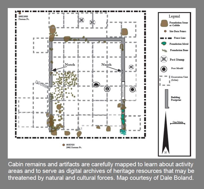
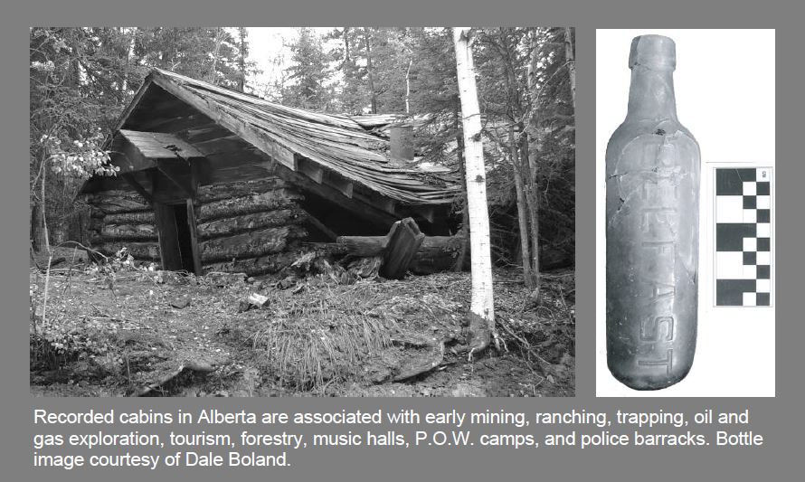
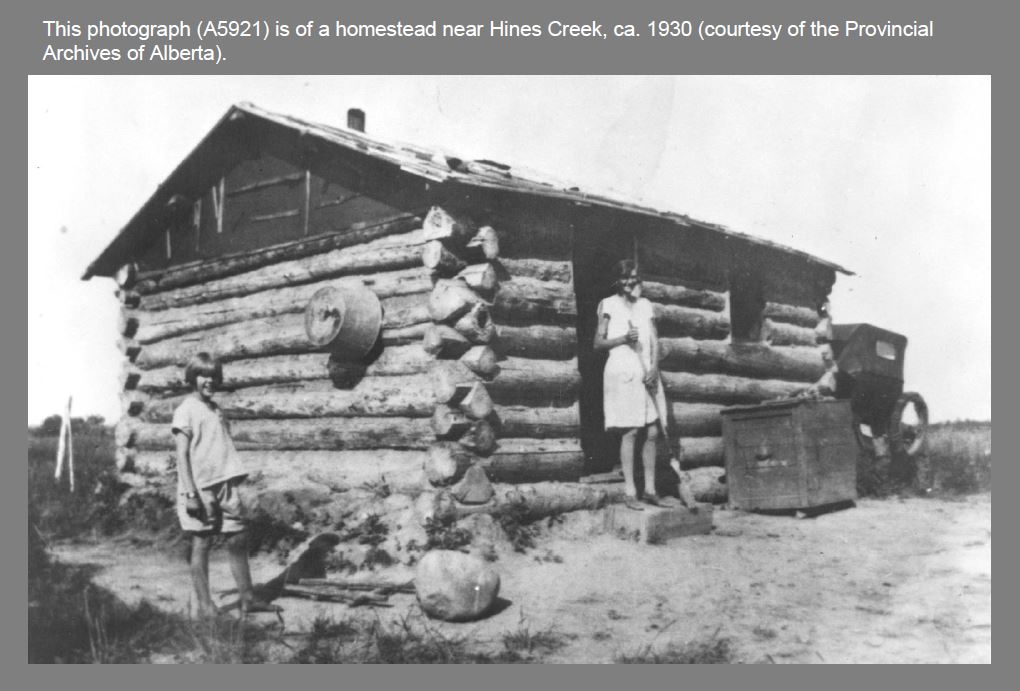
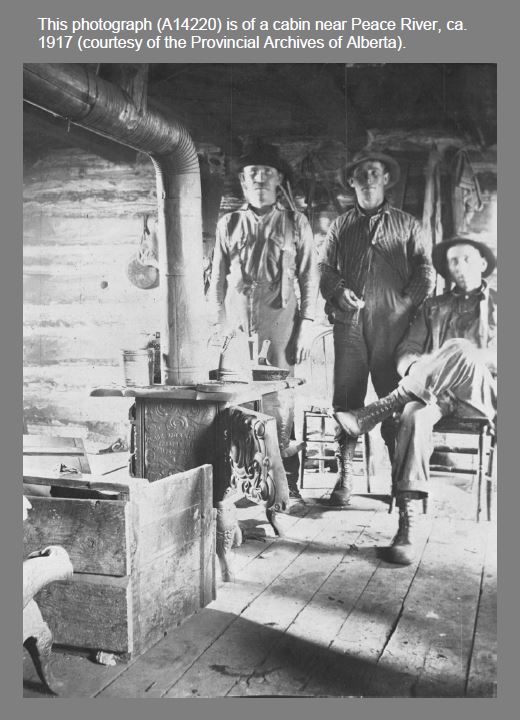
Cabins performed a variety of functions in Alberta’s past from homesteading to hunting and post offices to ranger cabins. Many events and daily challenges that defined our province unfolded on the wooden floors of early cabins. Just like the characters they housed, each cabin’s architecture and associated artifacts are unique.
To encourage an appreciation of cabins and the surviving record of them, as well as other historic resources in the province, a collaborative team from the Historic Resources Management Branch, the University of Alberta, and the Royal Alberta Museum initiated the Heritage Art Series. The goal is to create artworks that depict scenes from Alberta’s past that captivate public audiences. We hope that these artworks, like the cabin painting above, stimulate an interest in learning about our province’s heritage, which will in turn instill a greater respect for the past.
Cabins were typically made of raw timbers with a variety of corner joints, roofs, sawn floorboards, and chimneys. Associated features include outhouses, garbage pits, ice houses (for storing food), cellars, and drying racks. What can the archaeological record tell us about cabins and their occupants? Maps of cabins and associated structures reveal how people utilized landscapes and interacted with each other within cabins. Our modern homes are often relatively large with multiple rooms and levels, which is drastically different from the single-room cabins that many Albertans spent their lives in. An historical perspective informs us that changes in domestic architecture have had a real impact on the way Alberta’s families interact with each other and with their neighbours.
Cabins are often associated with historic trails that influenced how regions were settled and how goods were transported across the country. Cabin modifications over time tell stories of trial-and-error adaptations to new landscapes while artifacts can indicate the types of activities conducted around cabins, cultural affinities, number of occupants, and the season of occupation. Outhouses and garbage pits can reveal past diets, wealth, access to luxury goods, hygiene, medical conditions, and entertainment.
Aside from cabins’ phsycial make-up and artifact assemblages, they are significant heritage resources because they were often the first permanent structures to appear on many of Alberta’s landscapes. They represent a new adaptation and a new way of life for the people who first built them. There are over 550 recorded archaeological sites in Alberta with cabin components. Over 115 of these sites also have a pre-contact First Nations component, which suggests that many of the good spots for cabins have always been good places to make a living on the land.
The painting at the top of this article by Gregg Johnson is of a trapper’s cabin in the autumn foothills. It captures the solitude of the trapper’s life. Autumn was a busy time as trapper’s geared up for winter. Supplies were brought in, trap lines were re-established, and wood was cut for the long winter ahead. Like many of Alberta’s industries, modern trapping has an interesting past and an informative historic record. Archaeology offers a unique opportunity to learn about the past lives of people who may not be represented in historical accounts. In this sense, the study of historic resources gives a voice to people who have not been given the chance to speak for hundreds of years.
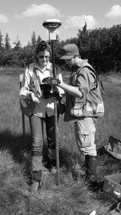
An example of a current research project about cabins that will illuminate the past record of a poorly understood group of people is that by Dr. Kisha Supernant at Buffalo Lake. Dr. Supernant and her research team from the University of Alberta are studying the adaptations of Metis and First Nations people who occupied Buffalo Lake in the 1800s in order to acquire meat that supplied neighbouring trade posts like Fort Edmonton. Her excavations and mapping program will uncover an important way of life that helped shape our province.
Dr. Supernant and a graduate student use GPS equipment to map archaeological features.
The next blog of the Heritage Art Series will be about the changing landscape and rock art of Writing-on-Stone Provincial Park.
Written by: Todd Kristensen, Northern Archaeologist, and Dr. Kisha Supernant, University of Alberta
In the boreal forest, where big game animals were often hard to find, fish were a life-saving staple for thousands of years. Archaeological and historical records reveal a wide variety of fascinating angling techniques used by Alberta’s First Nations.
To increase awareness of these practices and other elements of Alberta’s past, a collaborative team of the Historic Resources Management Branch, the Royal Alberta Museum, and the University of Alberta initiated the Heritage Art Series project. The goal is to create artwork that captivates the public in order to encourage the appreciation and protection of Alberta’s past.
The second painting in the series is a symbolic depiction of a mother teaching her daughter about the relationship between people and fish. First Nations survived in Alberta by passing down immense amounts of knowledge, which this image by Jenny Keith illustrates. The artwork also celebrates the role that women make to traditional diets. Fishng was primarily a women’s task in Northern Alberta. Women needed to know where to catch fish, how to make nets, how often to check them, and when to repair them.
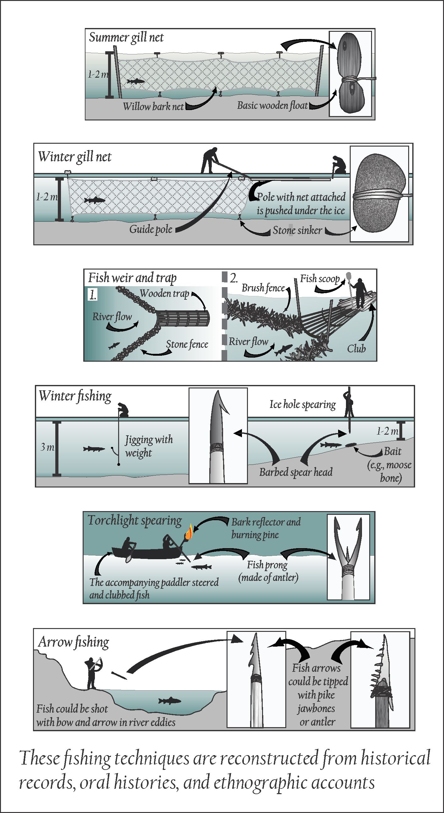
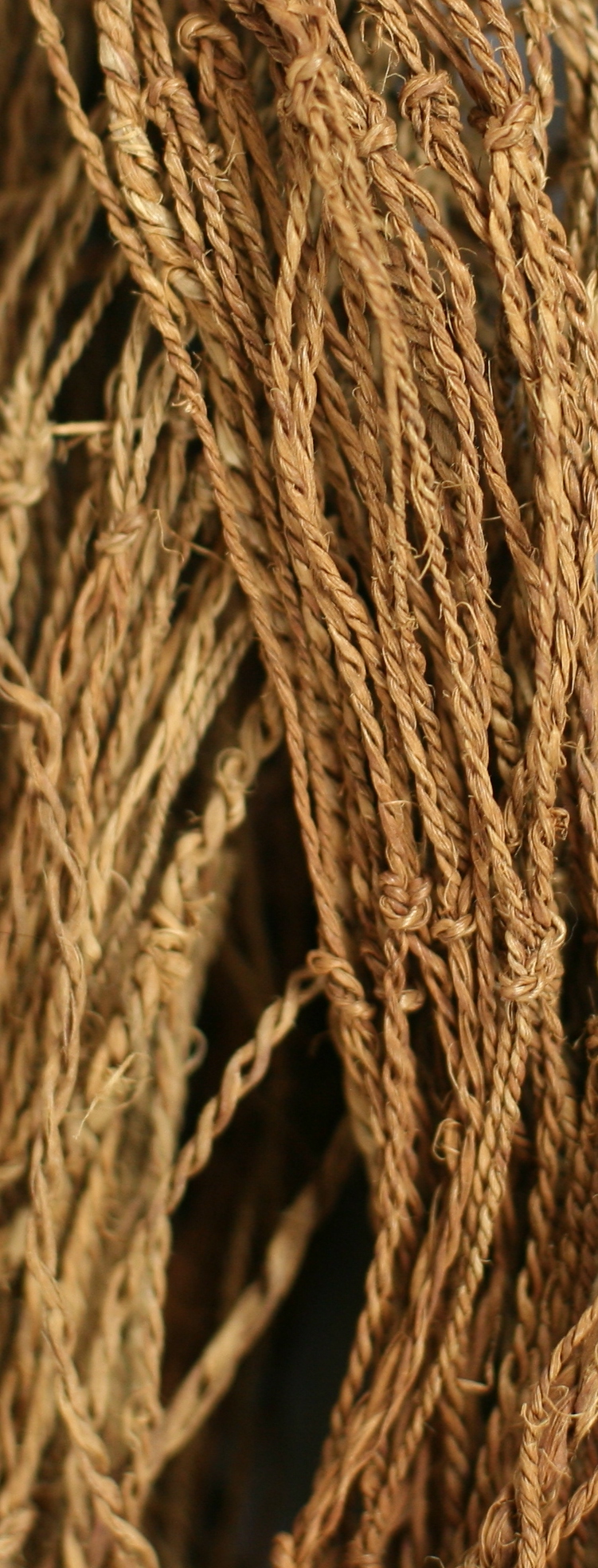
The largest catch of fish was traditionally by gill net during fall spawning runs of whitefish. Whitefish were particularly important because they are high in fat, which becomes scarce in the north during long winters. Gill nets are long rows of interconnected squares that capture fish by the gills. What were nets made of before twine? Amazingly, women spent hundreds of hours weaving twisted willow bark or animal sinew into long nets.
This is an example of a willow bark net from the Royal Alberta Museum.
Gill nets were set across rivers or narrow channels during warmer months or were strung through holes under the ice in winter. Large fish were also shot with bow and arrow or were speared by canoe. Some First Nations made fishing arrowheads out of pike jaw bones: nothing catches fish better than fish! Jigging with hooks made of bone and wood was also done, primarily in winter. Hooks were baited with meat scraps, hair, feathers, and beaver oil.
Fishing increased in importance when Europeans arrived. Fur traders in Northern Alberta made a living on pelts but they lived on fish. At Fort Chipewyan in Northeast Alberta, traders caught 33 000 fish from October to January in 1822. The ration was four fish a day (and a potatoe if they were lucky). Some northern trade posts even had to be relocated because they lacked good access to fisheries.
The archaeological record of fishing is sparse because fishing tools are often organic while fish bones tend to be fragile: very little of this survives in Alberta’s acidic soils. Some interesting fish-related fnds include possible stone fish hooks, bone prongs used on fish spears, sinkers (weights) that weighed down nets, and fish vertebrae that were drilled to make beads.
This is a collection of pre-contact fish-related artifacts from Alberta that span several thousand years.
Recently developed scientific techniques have also enabled the recovery of fish blood from the edges of stone tools like arrowheads and knives. Even though fish bones don’t survive, archaeologists studying blood residue have been able to determine that fish like pike, walleye, and whitefish were caught thousands of years ago. Lastly, fur trade forts have yielded an interesting array of early hooks. Some are entirely metal while others, like the example below, are a combination of bone and iron.
This fur trade fish hook was found by Jack McIntosh at Dunvegan near Grande Prairie.
When asked to imagine ancient life and food harvesting practices, people often think of men stalking mammoths or stampeding buffalo over cliffs. In reality, for much of Alberta’s human history, women have made just as important if not more important contributions to traditional diets. The painting above is intended to broaden perspectives of hunting and fishing practices while emphasizing the social dimension of food harvesting. People didn’t just survive by capturing food; they persisted for thousands of years by acquiring generations of knowledge that was passed down from parent to child year after year after year.
Stay tuned for the next installation of the Heritage Art Series, which will present the physical record of cabins and their significance in Alberta’s early history.
Written by: Todd Kristensen, Northern Archaeologist, and Dr. Jack Ives.