Cooking Lake with its cool breeze was the place to be in the halcyon summers to the end of World War I. The wealthiest Edmontonians spent summers in one of the rustic cabins, swimming, sailing and canoeing or lounging at the docks. Others had to make do with day trips and special picnic outings to the beaches on its south shore.
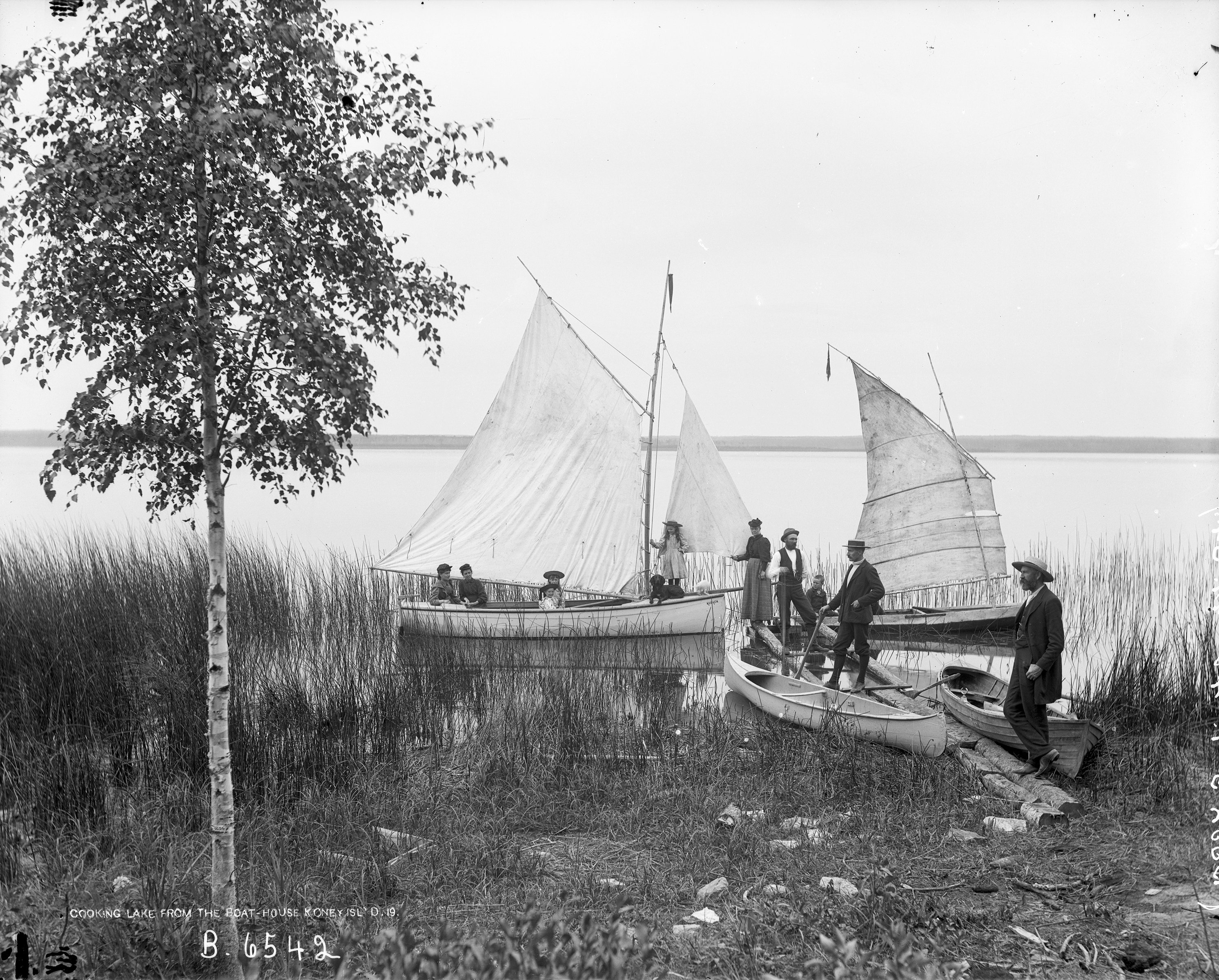
A group of prominent Edmontonians formed the Koney Island Sporting Co. Ltd. in 1894 to develop a small island located in a bay on the west side of the lake. It was an exclusive resort, complete with a log clubhouse nestled among the spruce trees. Members built cabins and erected docks. The serene lake waters were ideal for boating and one of the first club projects was a sailboat: the Mudhen. She was carvel-built using hand sawn lumber.
Koney Island Club member showing off their floatilla: The gaff-rigged sloop Mudhen, along with a row boat and two canoes, one with a small sail as was popular at the time. (Courtesy of the Provincial Archives of Alberta, B.6542.)
Koney Island was an isolated spot: Dr. Goodwin, one of the club members, may have been surprised to meet Dominion Land Surveyor Ernest Hubbel who arrived to survey its shores in 1895. Goodwin lent Hubbel a club rowing boat to do his work. The island offered a “splendid rendez-vous” for club members, Hubbbel noted, and was “a tranquil and exceedingly picturesque spot.” Nevertheless, club members may have tired of rowing out to the island when they arrived dusty and hot from Edmonton, as in 1898 they bought a 20 foot gasoline launch that could carry 12 passengers.
On the south side of the lake Sheriff Walter Robertson built a large lodge from logs and opened a resort in 1898. Here no company membership was required and holidayers could stay, enjoy the beach area and social functions at the lodge. The commercial resort slowly developed into the hamlet of South Cooking Lake, complete with post office by 1906.
Cooking Lake really took off as a summer lake destination in 1909 when the Grand Trunk Pacific Line to Edmonton passed along its north shore. Day trippers came out from Edmonton on the morning train east, alighting at the small station of Cooking Lake. Part of the day’s fun was crossing the lake on the motor launch Daisy Girl that operated as a taxi to White Sand Beach on the south side at Ministik, where children built sandcastles before the evening’s return trip.
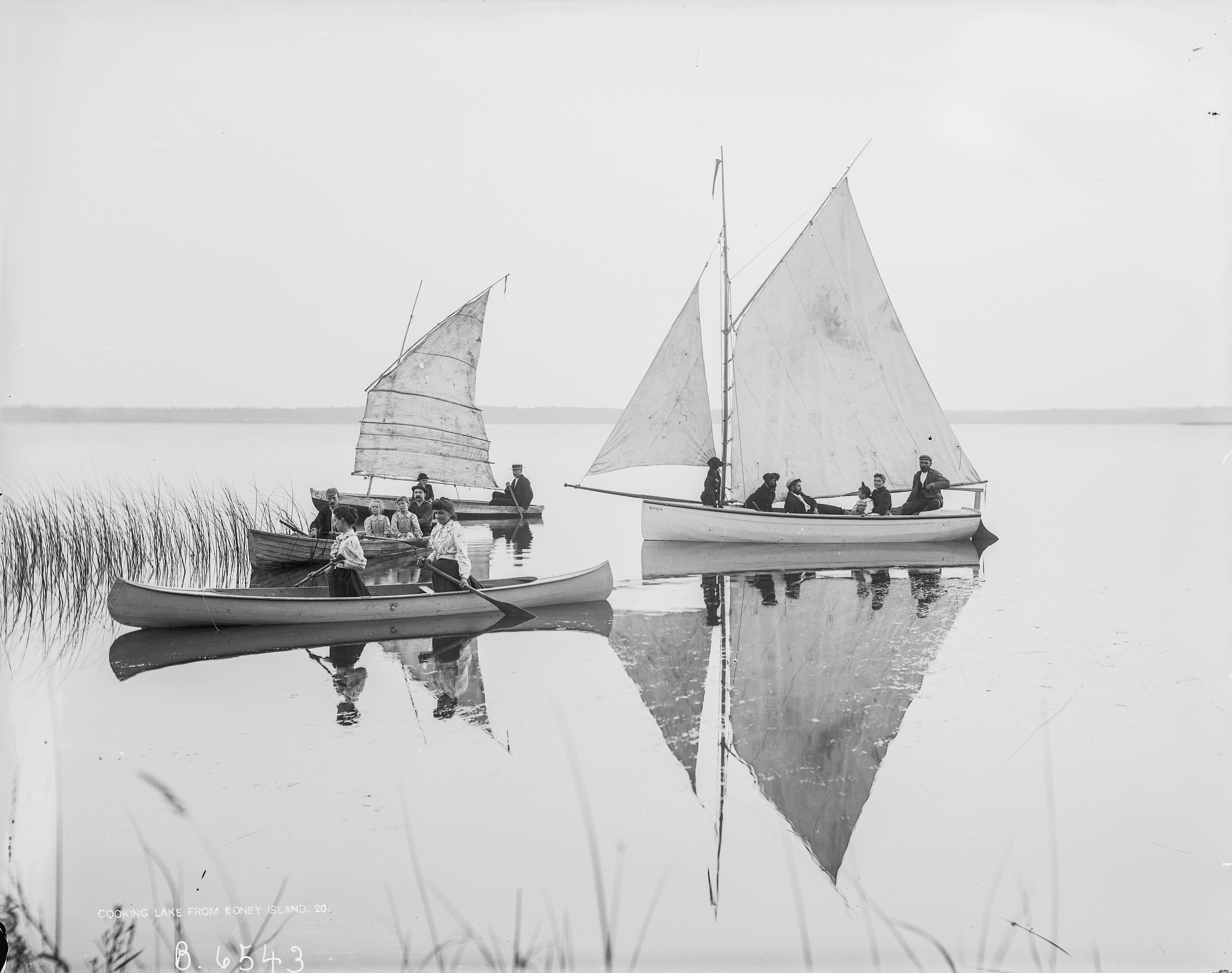
The gaff-rigged sloop Mudhen becalmed at Koney Island, along with two canoes, one with a small sail as was popular at the time. (Courtesy of the Provincial Archives of Alberta, B. 6543.)
Company picnics for employees were popular. The Esdale Printing Company picked a warm day in 1914 for its annual outing. Couples sat by the shore watching children swim or splash about. Some women had umbrellas for shade while other relied on their straw hats. A tug-of war competition was organized among the women, while a group of men spent most of the afternoon roasting an entire calf on a spit built over a camp fire. Everyone sat down at long trestle tables to enjoy the meal in the shade of the trees.
Cooking Lake was a destination for outings on Empire Day (celebrated on the school day immediately preceding May 24). The day had beautiful fine weather in 1916, which must have sorely disappointed the young people in Edmonton’s First Presbyterian church group, who cancelled plans for a picnic and boat ride due to incessant rain the previous day. Church camps were held at the lake, and the Young Womens’ Christian Association had a bungalow at Military Point.
By 1916 many Edmontonians had cabins at Cooking Lake. A taxi service was available from the city and motorists increasingly ventured out for the day. More facilities and accommodations were built on the lake shore, which had a graded “lake promenade.” Lunch could be enjoyed at Mrs. McMenomy’s “high class restaurant,” and canoes and row boats hired by the hour. Further along the promenade at South Cooking Lake, visitors played pool at Chris Falks’ ice cream parlour.
Larger motor launches were evident on the lake in the 1920s and soon sea planes were landing on its waters, even before a seaplane base was built in 1935. The Cooking Lake Sea Plane Base was used recreationally as well as by bush pilots returning from the north. While other lakes around Edmonton enticed vacationers, Cooking Lake, the city’s first summer escape, remained popular into the 1960s. Water levels and water quality at Cooking Lake have always fluctuated: Koney Island became a peninsula in 1962. Sailors and swimmers became disenchanted during the 1970s. The summer of 2007 brought a record low-water level stranding the lake’s piers and cabins. Although waters have risen again recently, it seems unlikely that long summer days at the lake will ever be as cookin’ hot as they were a hundred years ago.
Striking a Balance for Alberta’s Nonrenewable Archaeological Resources
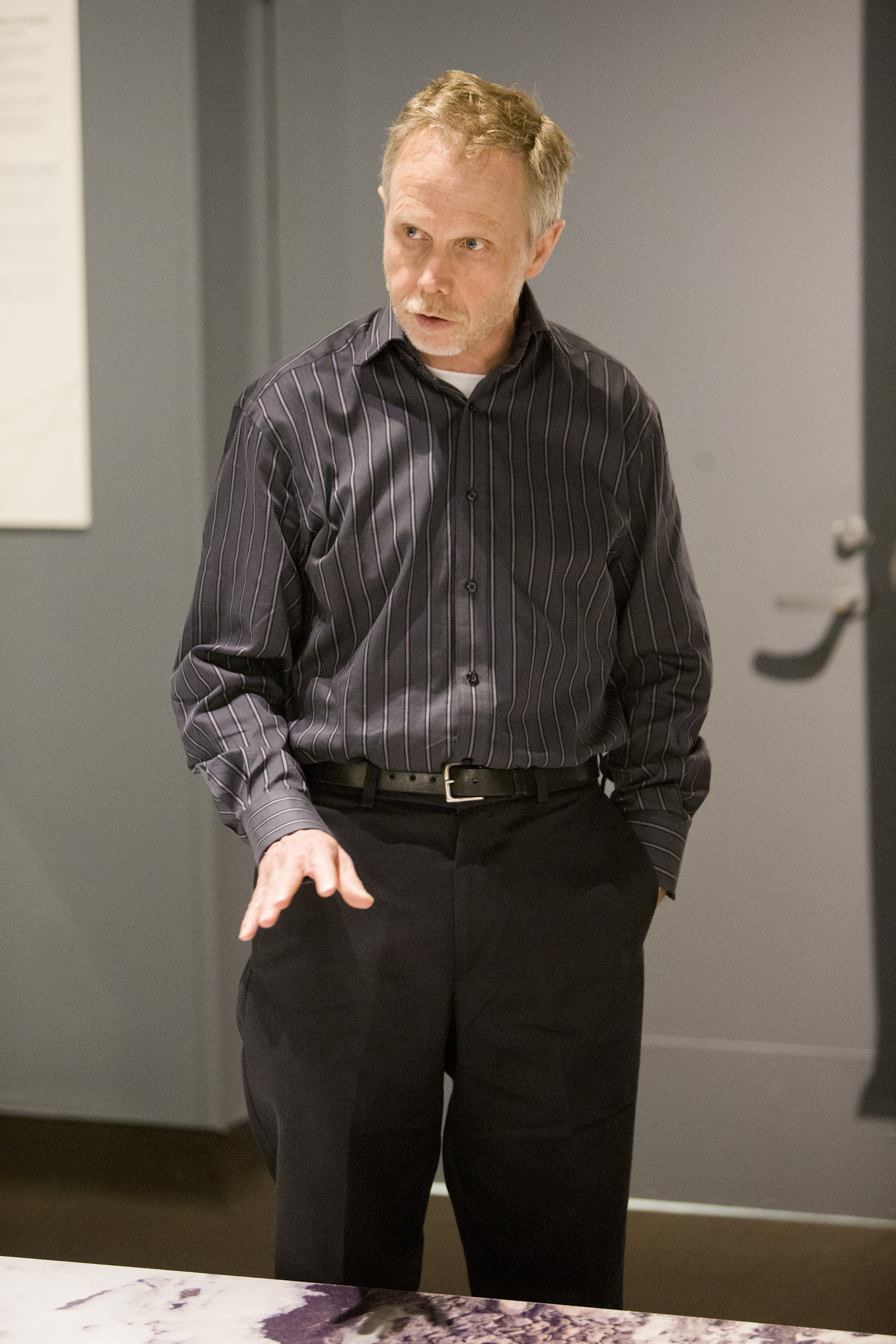
For Eric Damkjar, Head of Archaeology, what the Archaeological Survey Section of the Historic Resources Management Branch does is akin to running a museum. Not a traditional museum, composed of artifacts encased in glass boxes under lock and key. Instead, archaeological specimens are scattered “across the landscape in the province, and [we]’re trying to look after those specimens,” reflects Damkjar.
Eric Damkjar, Head of Archaeology
The Archaeological Survey Section has a mandate to protect and to interpret the province’s archaeological heritage. This necessitates striking a balance between protecting archaeological sites through regulating and redirecting development, and unlocking the knowledge of Alberta’s prehistoric past through excavation projects that, ironically, are triggered by development.
Archaeological Survey maintains a database of some 40,000 archaeological sites in Alberta that includes known historic resources as well as lands that are “highly probable to have historic resources.” About half of those places have been further identified as high priority sites requiring protection. The provincial government relies on its relationships with different industry sectors, such as oil and gas, to become aware of potential risks to these sites. Those proposing development projects must check whether the potentially affected lands are included in the provincial database of sensitive areas, and if so, proponents must send Archaeological Survey their development plans. Damkjar and a team of archaeologists review the plans and decide if there is a need for a Historical Resources Impact Assessment (HRIA), which will recommend a course of action.
Archaeological Survey’s preferred action is for the proponents of development projects to voluntarily change their plans to avoid sensitive sites. When impact is unavoidable, the department prescribes excavation. Damkjar’s team then reviews the work, and determines whether the knowledge generated from excavation has compensated for the site’s destruction. But in some cases, Damkjar says, “the Act gives us the discretion [to say], you can’t develop that site, it’s too important to [the people of] Alberta.”
An example of the excavation option can be seen in the town of Hardisty. Today, many pipelines that are built in the province converge there. Twelve hundred years ago, people drove bison into a buffalo pound near Hardisty. Next to that site, they processed hides and meat. This area, so rich in archaeological significance, is today heavily impacted by pipelines: one was put in last year, one is currently under construction, and another one is proposed. “Bit by bit,” Damkjar states, “these pipelines are eating into these sites.” The proponents of the pipelines, constrained by geography (namely, a nearby river) and unable to avoid impacting the sites, have been required by Archaeological Survey to perform a great deal of excavation work. “It’s turning into a very interesting site,” notes Damkjar, yielding a glimpse of a culture that archaeologists call Avonlea.
Archaeological Survey works closely with other sections within the Historic Resources Management Branch, such as Historic Places Stewardship and Aboriginal Heritage, to identify and address potential risks to sites. The section is working to build relationships, too, with First Nations. “Obviously, prehistoric archaeology in Alberta is very relevant and close to the heart of First Nations people,” notes Damkjar. This realization has led Damkjar deep into Treaty 8 territory, into the forests of northwestern Alberta and the homeland of the Dene Tha’. Exploring campsites, Damkjar went with a group of Elders to places where they had lived as young people. “You could see the remains of their camp from the early half of the twentieth century, but right at the same site, there were prehistoric tools there, as well. So people had lived there for hundreds, maybe thousands of years. For them, and for us, it was quite exciting.”
That bridge between past and present is just one of the reasons why preserving prehistoric archaeology is so important. Archaeological historic resources, Damkjar reminds us, are nonrenewable—once they are destroyed, they are gone forever. However, when a historic resource is successfully avoided by proponents of development, and hence preserved, Damkjar points out that “you’re leaving the information that could be learned in the ground.”
The decisions that the Archaeological Survey Section makes are sometimes a leap of faith, says Damkjar. It’s not guaranteed that a protected site won’t be impacted, someday, by human activity; it is also not guaranteed that someone, eventually, will unlock the wealth of information that a protected sites holds for us. These are the challenges of planning for the future, notes Damkjar, but in the context of knowing that nonrenewable archaeological resources will continue to be threatened by development, the Province’s responsibility is to do what it can to protect them.
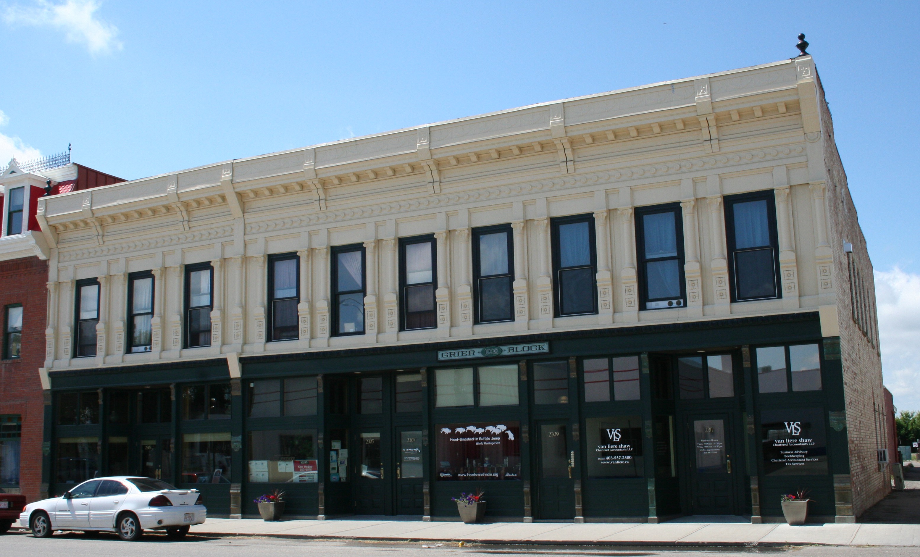
Grier Block after rehabilitation was complete (July 2014).
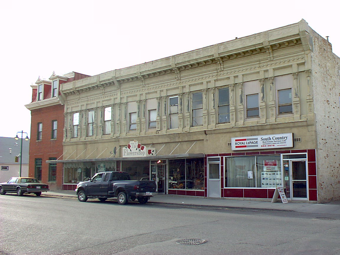
The Grier Block, built in 1902, was one of the first and largest commercial buildings in Fort MacLeod. It has one of the only pressed-metal facades in western Canada, highly decorated with an elaborate cornice and pilasters (columns between the window bays). Peter Maas recalls that by the early 2000s, when he and his brother Hans purchased it, the once-distinguished building was “pretty dilapidated.” The brothers spent seven years on a major rehabilitation (working full time, without pay, living on the premises) that brought the building back as a prominent and attractive contributor to Fort Macleod’s historic downtown. They recently added some long-missing and key elements, returning the building to its full glory.
The rehabilitation work included adding insulation and making other upgrades to the building envelope (the outer shell separating the interior from the exterior), accurately replacing the historic windows and frames, and preserving the original pressed-metal facade still present on the upper floor. (For a detailed account of the rehabilitation of the Grier Block, see pages 6 to 9 of the Standards and Guidelines for the Conservation of Historic Places in Canada.)
Unfortunately, the first-storey cast-iron pilasters had been missing since the 1960s, so the brothers only restored what was there at the time. It was fairly common to remove decorative facades from commercial buildings during the 1950s, ’60s, and early ’70s, says Fraser Shaw, the Heritage Conservation Advisor for Southern Alberta. Ground-level elements corrode more readily. Also, at mid-century, out-of-fashion ornamented facades were often modernized at street level, as this one was, with expanses of plate glass windows with plain surrounds.
The brothers were never satisfied with what they considered an incomplete restoration: “That was the only piece to the puzzle that was missing,” Peter says. “We’ve gone 100 percent on everything else, and that was the only thing that was left to attend to, so it was important to us to have that finished.”
The Grier Block in 2001, many years before the restoration began (November 2001).
Now—thanks to their perseverance, resourcefulness, and the lucky confluence of the right people at the right time and place—those first-storey pilasters have been replicated and are back in place. It’s “the crowning touch…the icing on the cake,” says Fraser. The building is designated as a Provincial Historic Resource, so his role during both the original rehabilitation and this project was to verify the historical accuracy of the proposed changes and monitor the work.
During the rehabilitation project, the architect in charge, Robert Hirano, made an important discovery: the building has a Mesker Brothers facade. In the late 1800s and early 1900s manufacturers introduced mass-produced prefabricated building components made from sheet-metal panels stamped with decorative motifs and iron elements cast in moulds. These processes provided an easy and inexpensive way to imitate elaborate decorations that historically had been created by craftsmen in more expensive materials such as carved stone. The products were sold through mail-order catalogues and shipped by rail throughout North America. Mesker Brothers Iron Works of St. Louis, Missouri, was one of several companies that created and shipped entire building facade and storefront assemblies. (One competitor was the George L. Mesker Company of Evansville, Ind., owned by another brother.)
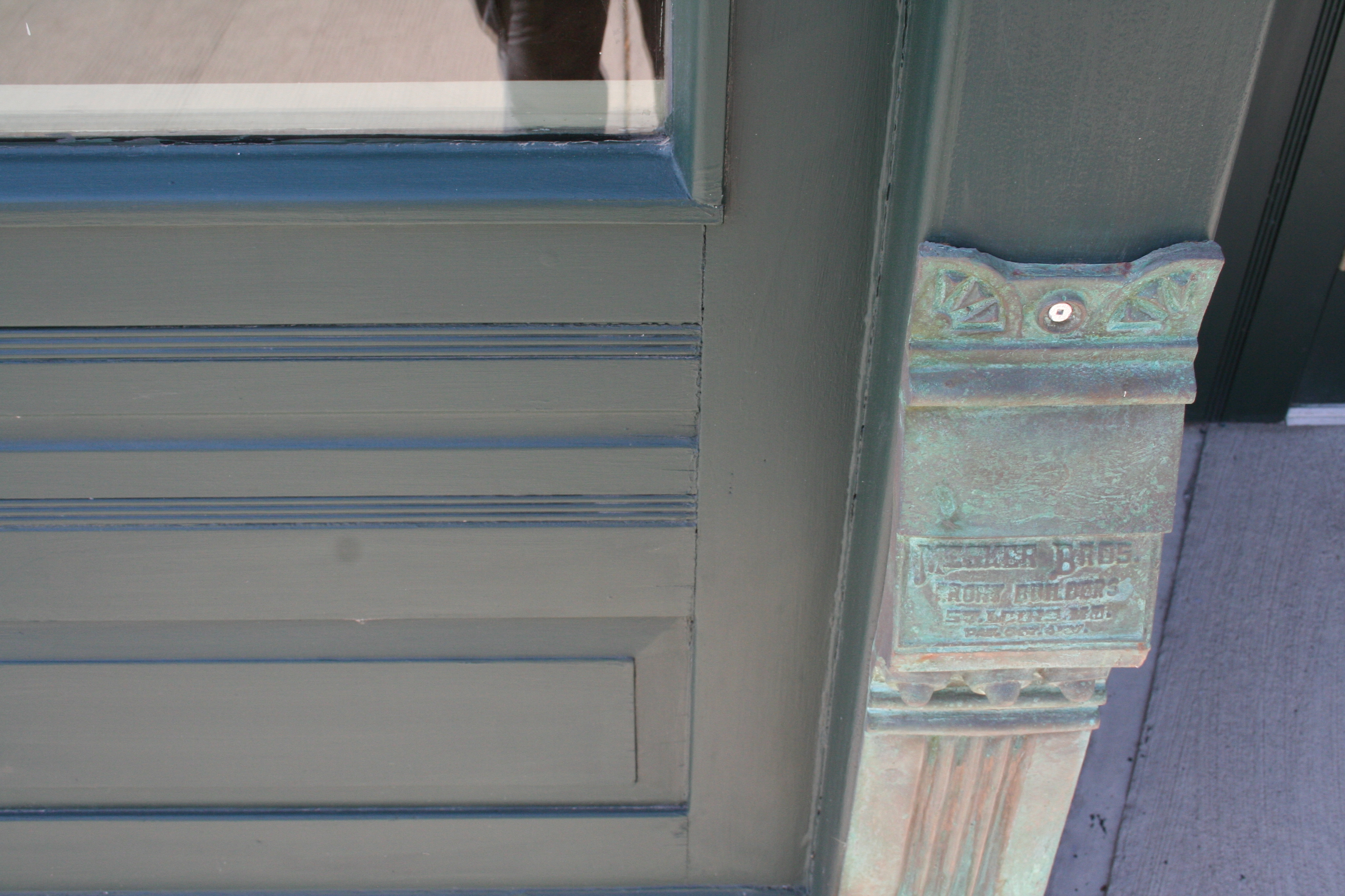
A close-up of the rehabilitated metal detailing (July 2014)
Buildings with Mesker Brother facades are plentiful in the U.S. East and Midwest, with numerous Western examples as well, especially in Colorado, Wyoming, Montana, and Washington. The Grier Block has one of only a handful of Mesker facades known to have existed in Canada, with two other Mesker facades installed in nearby Lethbridge—the Metcalfe Block (“Club Cigar”) and Lethbridge Hotel—no longer surviving. Fraser speculates that the developer of the Grier Block might have had U.S. connections, and benefitted from convenient cross-border rail service between southern Alberta and the U.S.
Over the years, Peter Maas had been hunting for Mesker storefronts with pilasters identical to those that once graced the Grier Block, hoping to replicate them. Specifically, he needed to find models for pilasters that are six inches and thirteen inches wide, each with a lower, a middle, and an upper component. All together, 33 individual elements needed to be produced to complete the lower facade.
The original structural steel pilasters of the Grier Block were still intact. Outlines of old paint showed where the ornamental cast-iron pilasters had been, and there were even tool marks showing where they had been hacked off. The owners had historic photographs of the building and the Mesker Brothers catalogue to show how the missing elements should look, and Hirano had produced drawings. “But at the end of the day, you need something that’s full scale and more tangible” to create the accurate, full-sized building elements, Fraser says.
During the rehabilitation work, the Maas brothers hired a carver to create the pilasters out of wood, but the result was disappointing. Later they located a Mesker Brothers building with one of the two needed sizes of pilasters while vacationing in New York State, and used those to create rubber moulds. But because those pilasters had decades of encrusted paint, the resulting moulds lacked definition.
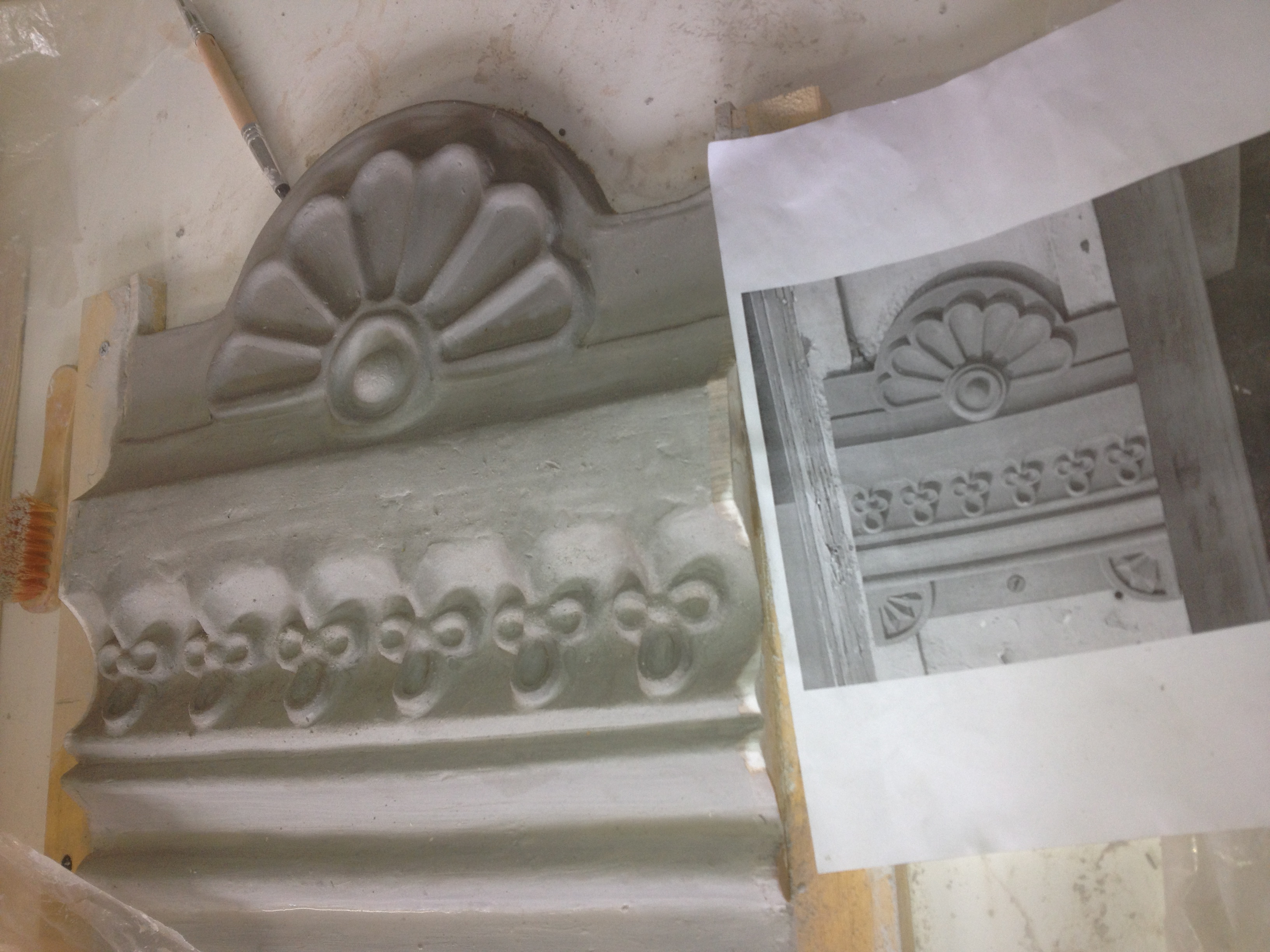
One of the clay model prepared for the casting process (February 2013).
Then everything came together last year when Peter was on vacation in Colorado.
Always on the lookout for Mesker Brothers buildings, he tracked one down in the small town of Mancos, in southwestern Colorado near Durango. It had the six-inch pilasters he needed! While gazing at them, he struck up a fortuitous conversation with a passer-by. That was Collette Webster, a professional potter. She considered how to replicate the pilasters, then came up with a solution.
Remarkably, the building owner allowed them to temporarily remove the pilasters. Collette was able to make plaster moulds of the three sections, and from those make clay templates that could be used for casting the elements in metal through the lost wax process.
On the same trip, Peter found a Mesker Brothers building with the thirteen-inch pilasters on the main street of Telluride, Colorado. In that case, the pilasters couldn’t be removed, so he took lots of photographs. Collette referred to those and to the moulds for the six-inch pilasters to create scaled-up models in wood of the thirteen-inch pilasters. These could then be used to make the necessary plaster moulds and wax models.
Some decorative detailing was still needed. As a potter, Collette was able to craft the missing roundels, florets, and other flourishes out of clay and then attach those shapes to the templates used to create the wax models.
The sections were cast in bronze by craftsman Dimitry Domani at his foundry in Cortez, Colorado, then shipped to Sweetgrass, Montana, for Peter to collect at the border. Domani recommended using bronze rather than the original iron because it has the potential to develop an attractive natural patina over time, whereas the iron would need to be painted.
The Grier Block’s new pilasters are now bolted into place, as they would have been historically, and also welded on “as an extra safeguard,” Fraser says.
“In all, the project seems to have been a lucky convergence of passionate owners, Mesker buildings in Colorado to serve as templates, and a network of local (in southern Colorado) artisans to perform the work where the buildings were,” Fraser concludes. The project was assisted by a matching conservation grant from the Alberta Historical Resources Foundation.
Today the Grier Block is fully occupied. On the first-storey are an insurance and a real estate agency, a stained-glass artisan, a visitor display and offices for Head-Smashed-In Buffalo Jump, and one residential suite; the second storey contains seven residential suites.
“There’s no question that it’s an anchor within the historic commercial district,” Fraser says. And “now the building just resonates with character in a way that it didn’t before.”
“It’s a nice piece of history for the town,” Peter agrees.
Hans Maas, a chef by training, had completed the historic rehabilitation of a smaller Fort MacLeod building as a “hobby,” Peter says, before tackling the Grier Block. Peter had experience constructing new buildings, but this was his first historic rehabilitation project. “I’m addicted to historic buildings now,” he says. “I find the historical projects are way more rewarding…You’ve got to go back to good material and quality workmanship.” He has since purchased and is now hard at work restoring Fort MacLeod’s Reach Block.
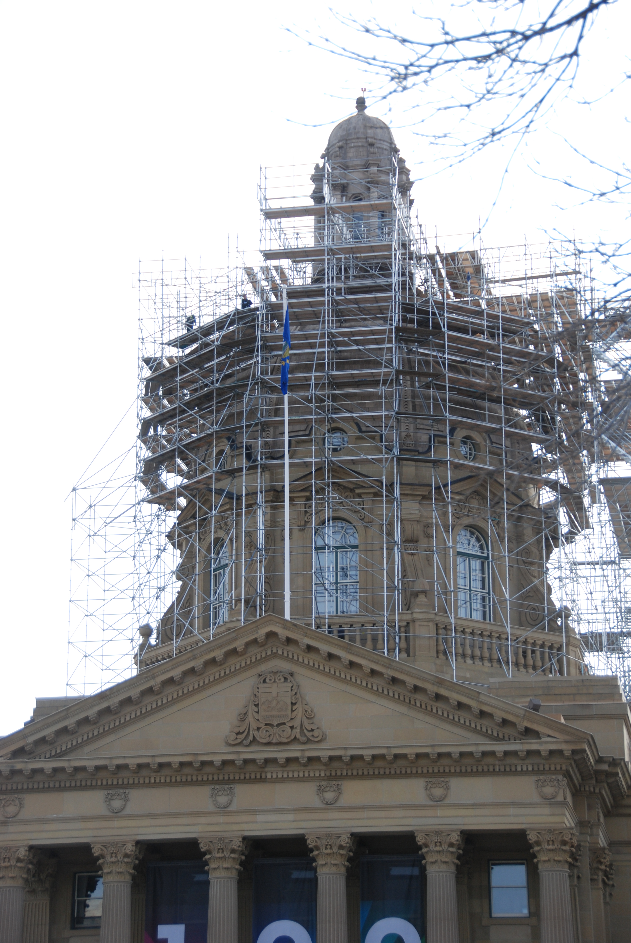
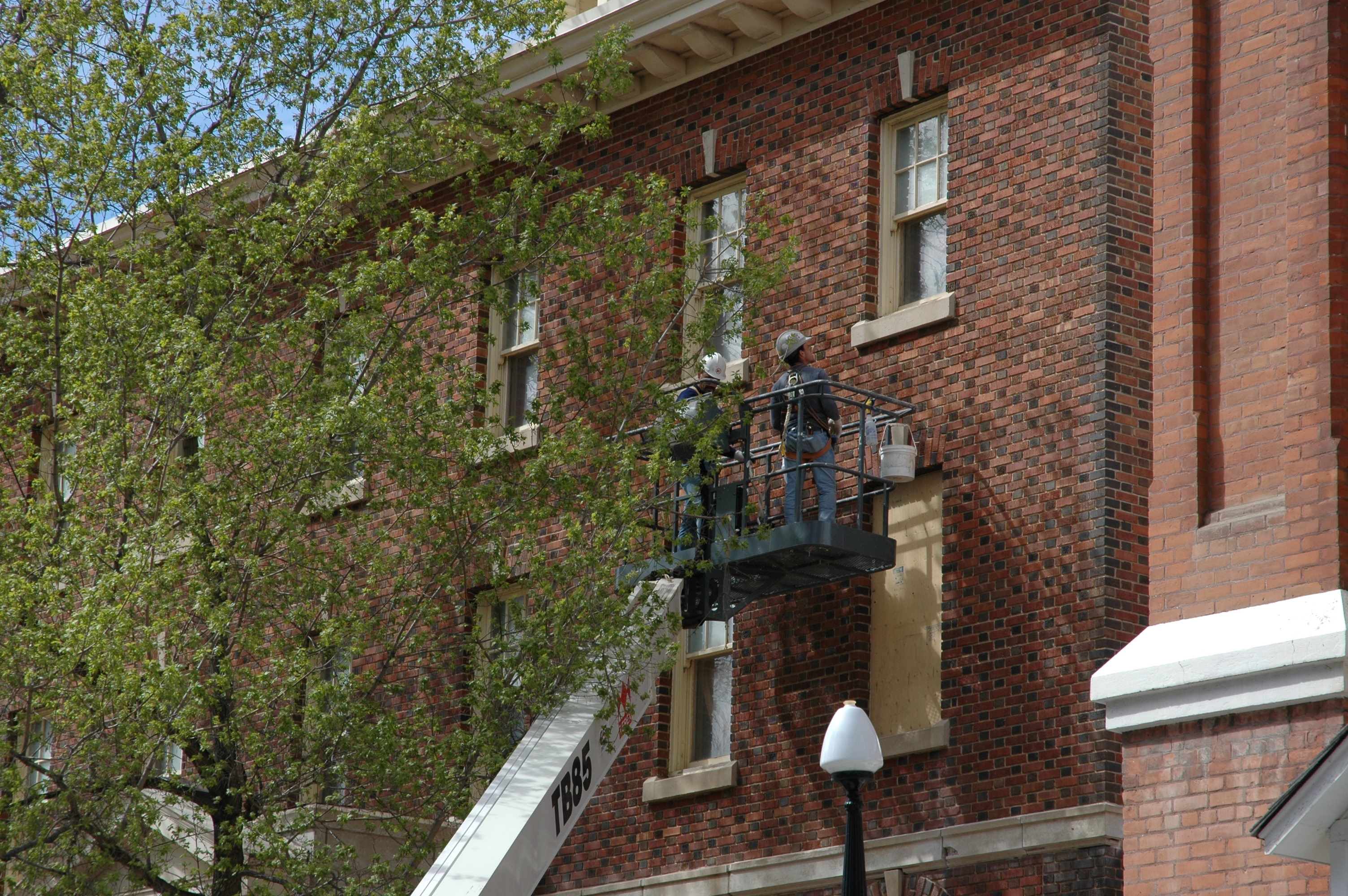
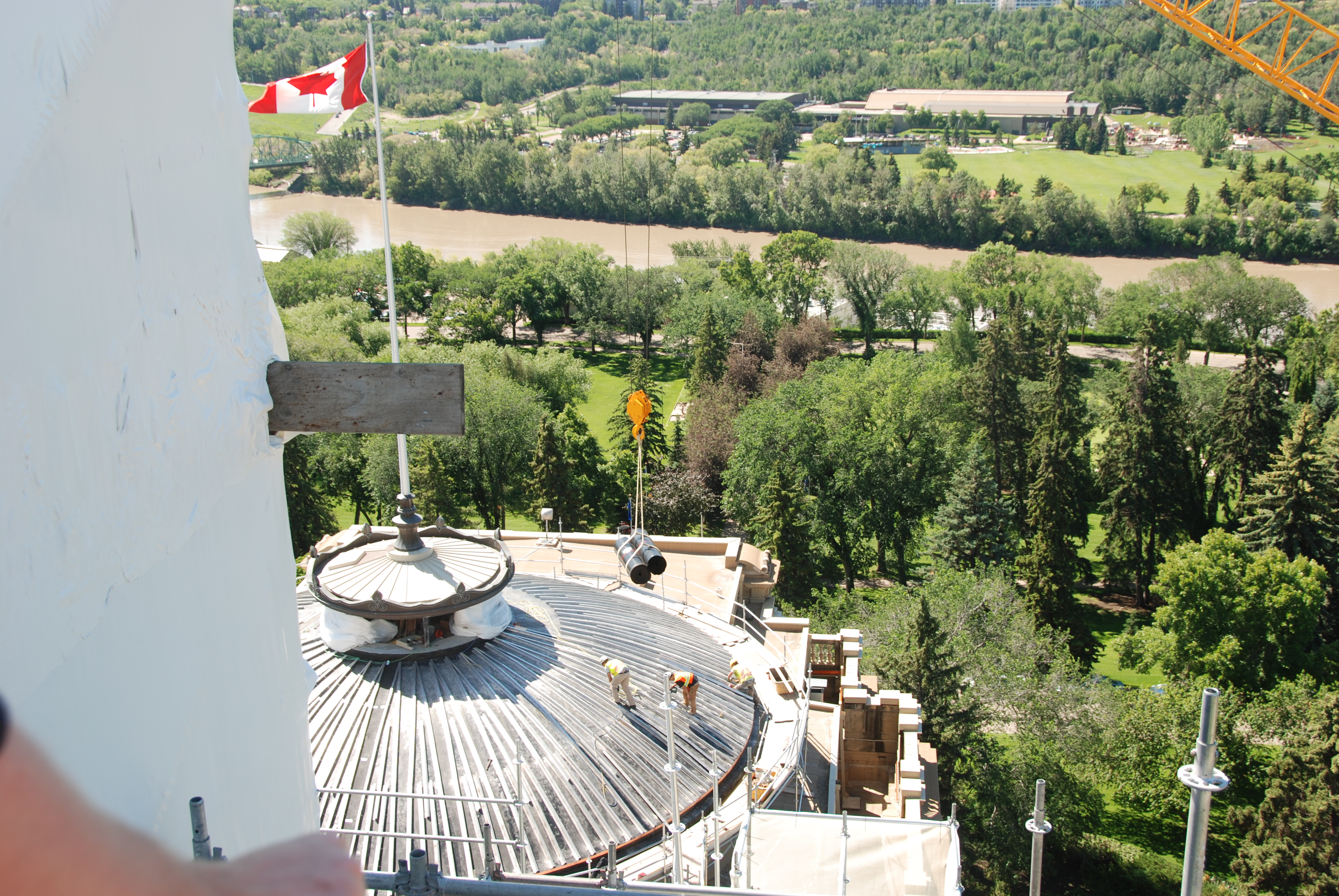
Scaffolding around the Alberta Legislature Building’s dome (2012).
When Tom Ward stated doing heritage conservation work some 35 years ago, he had no idea if it would lead to long-term employment. But he was hired early in his career to be part of the design team developing the Ukrainian Cultural Heritage Village east of Edmonton (a great learning opportunity, he recalls), and has been involved in heritage projects across the country ever since. Currently Ward is Manager of Heritage Conservation Advisory Services for the Historic Resources Management Branch, supervising five Heritage Conservation Advisers.
The Heritage Conservation Advisers are not the preservation police! In fact, Ward says that the vast majority people who own designated historic resources appreciate the historic character of their properties and are eager to maintain them in an appropriate way. “We take a partnership approach,” he continues. “Even though in the back of our minds we are trying to make sure that the work meets the Standards and Guidelines, our approach is that we are there to help.”
More than half of the advisers’ time is spent in onsite, face-to-face meetings with individual owners, groups, or developers. “Meeting people and seeing the historic places is really the great part of the job,” Ward says. The advisers provide technical guidance on the best ways to accomplish needed work; may recommend qualified architects, engineers, and contractors if needed; and also determine if the property owner might qualify for cost-sharing grant assistance from the Alberta Historical Resources Foundation. They ultimately produce a ministerial approval document package which satisfies Section 20 of the Historical ResourcesAct and allows the work to proceed.
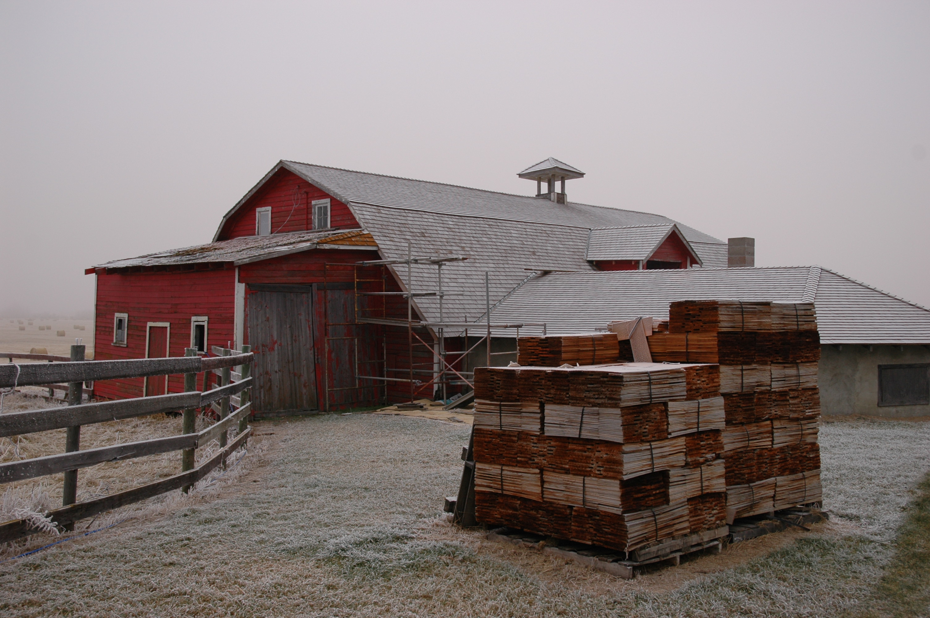
For example, if a heritage property needs a new roof, the adviser would steer the owner toward the historically appropriate choice of replacing original cedar shingles in kind rather than using cheaper asphalt shingles. “We would specify the kind of shingles the homeowner should use, the exposure, the underlay, the flashing, that sort of thing. Then we can say, this is going to cost you a little more, but it will last you longer and better meet the Standards and Guidelines. You are also eligible to submit an application to the Alberta Historical Resources Foundation to cost-share on that roof so that it brings down your cost to about that of an asphalt shingle roof.”
A historic barn in east-central Alberta being re-shingled (2005).
The result is satisfying for all: “You get very positive, immediate feedback from people when you’re having a conversation over their kitchen table. They really appreciate the technical advice we can give them. And you see the job ultimately done well, ensuring that good conservation happens in Alberta.”
The Heritage Conservation Advisers address the needs of privately owned properties as well as Alberta Culture’s historic sites which are also designated as Provincial Historic Resources. Ward also consults with Alberta Infrastructure when work is needed on Provincially owned heritage buildings administered by that ministry. Recently he was involved in planning conservation measures for the Alberta Legislature Building, especially repair and reconstruction of portions of its dome. Ward and his team also provide technical consultation to other programs of the Historic Resources Management Branch, such as the Municipal Heritage Partnership Program, and meet with property owners considering pursing heritage designation.
The announcement of provincial funding to assist owners of historic properties affected by the 2013 flooding in Southern Alberta will almost certainly mean more “house calls” to owners now undertaking or planning repairs. “It’s going to be an additional workload, but everybody is keen to do it,” Ward says.
He also sees this as a great opportunity to study the effects of flooding on sandstone and fieldstone foundations that are so prevalent in older buildings here, and determine best practices for restoration. The team holds occasional “retreats” to explore a technical issue in depth, through review of professional literature and discussion of their own onsite experiences. The next retreat will, of course, be about addressing flood damage.
The Alberta Legislature Building’s dome being restored (2013).
Ward says it’s typical of his team members responsible for the flooded areas that all were willing to work overtime, going to flooded areas as soon as they were allowed in, to advise owners on urgent matters, especially the best ways to dry out foundations.
“I’m really proud of the team we have,” Ward concludes. “They are passionate about what they do, and they are passionate about public service.”
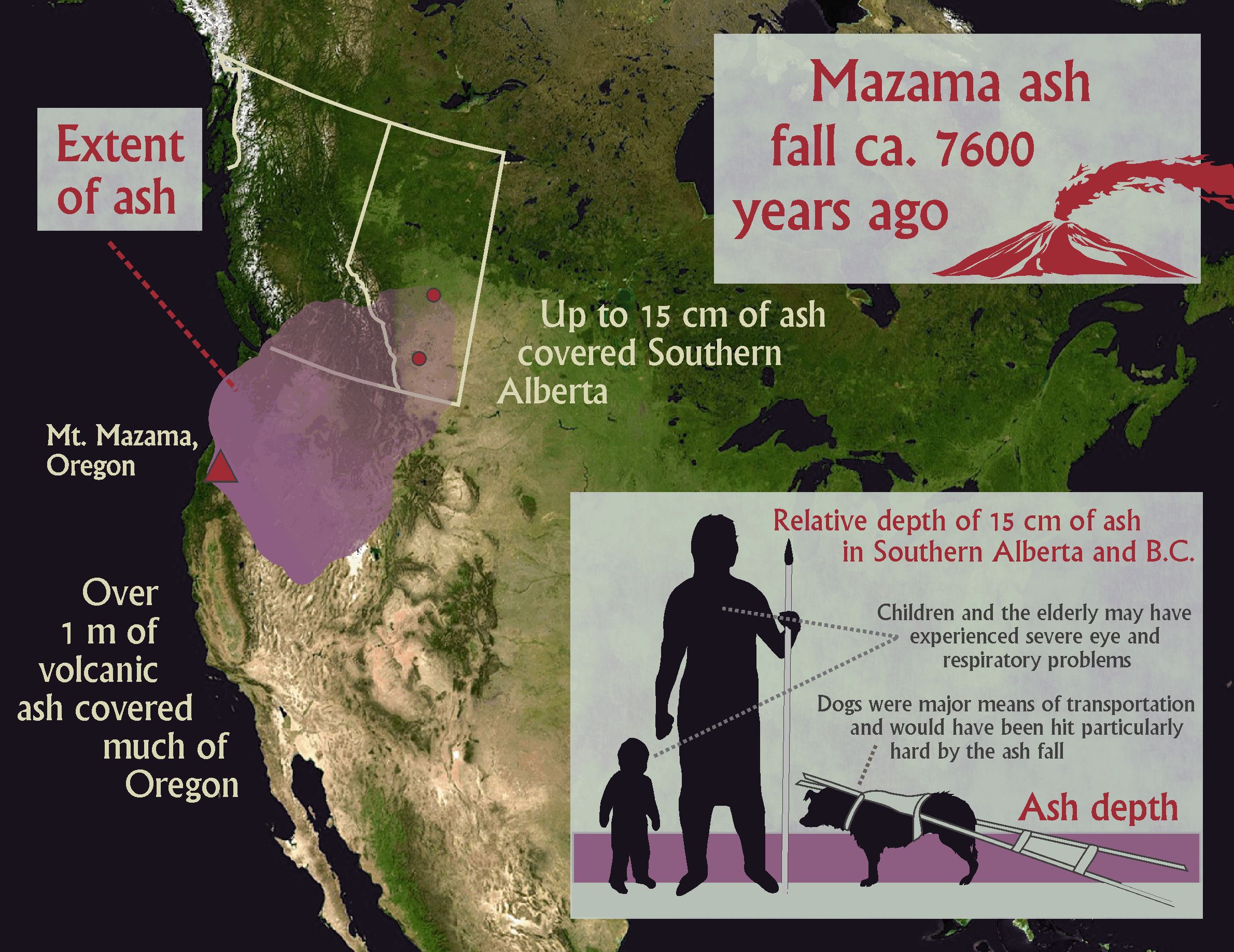
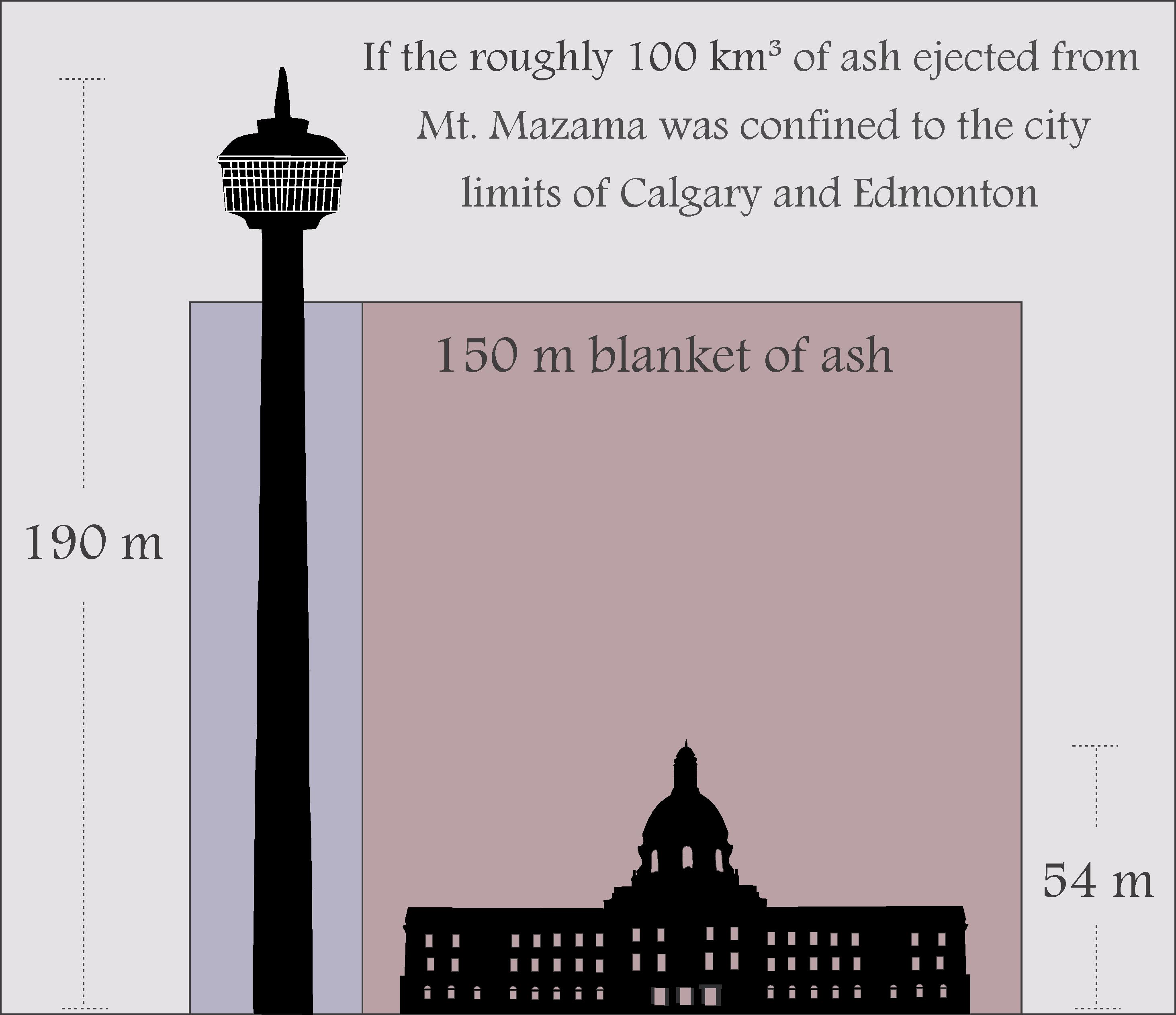
Did you know that one of the largest ecological catastrophes in Alberta’s human history was a volcanic ash fall? Around 7600 years ago the skies were blackened for many days and the prairies of Alberta were blanketed with roughly 15 cm of ash ejected during the Mazama eruption.
To create awareness of this event and other important moments in Alberta’s past, a team from the Historic Resources Management Branch, the University of Alberta, and the Royal Alberta Museum initiated a project called the Heritage Art Series. The goal is to captivate public audiences with artwork that creatively explores ancient landscapes, relationships between people and their surroundings, and the enduring physical record of human activities. We hope the series inspires a desire to learn more about our province’s heritage and that a greater awareness of the past will instill a deeper respect for it. We’ll release the first four paintings in the series over the coming weeks with explanations about the significant events and figures that each scene depicts.
The first painting (above) by Karen Bishop captures a surreal landscape of Southern Alberta as it would have looked 7600 years ago during the Mazama volcanic eruption. While the volcano that erupted was in Oregon (at modern day Crater Lake), it only took about 12 hours for some of the estimated 100 km³ of ash to reach Alberta. The ash smothered plants, contaminated fresh water, and would have filled animals’ lungs. Airborne particles would have caused intense lightning storms. Huge swaths of dead vegetation combined with frequent lightning led to widespread fires.
This map shows the spread of Mazama ash into Alberta. The inset depicts the depth of Mazama ash relative to people and dogs.This figure depicts how deeply Edmonton and Calgary would be buried if all of the ash from the Mazama eruption were confined to the city limits.
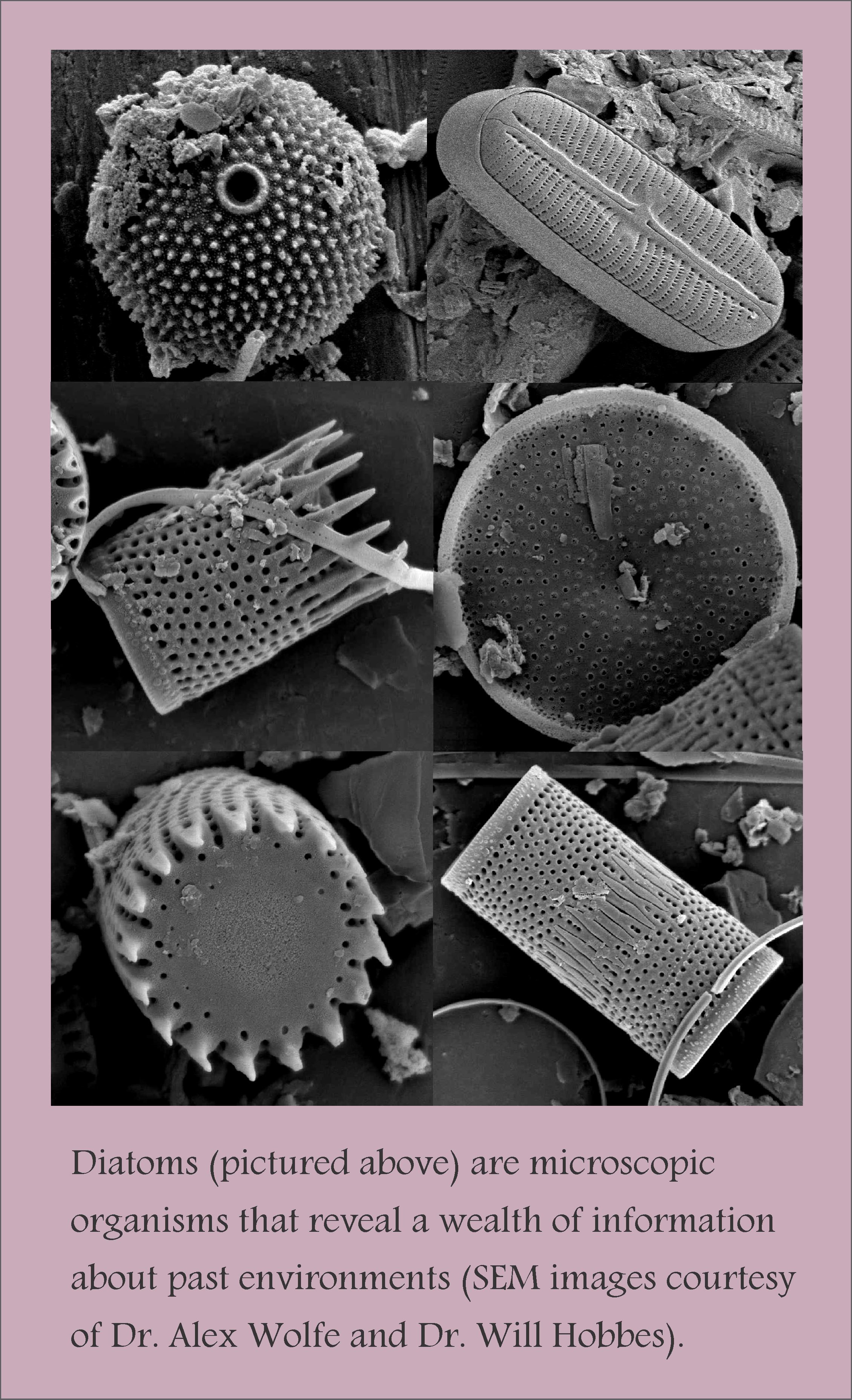
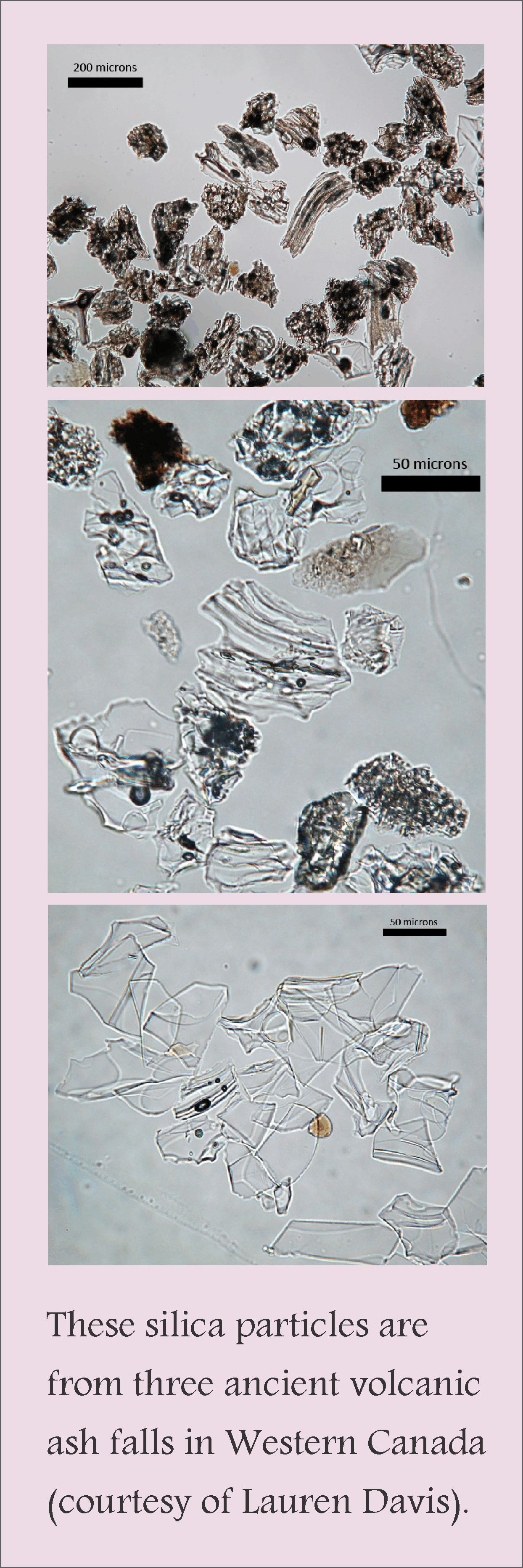
By studying micro-organisms and microscopic silica particles in soils and lake beds, scientists, including a team of ‘tephrochronologists’ led by Dr. Duane Froese from the University of Alberta, are learning more about the ecological impact and timing of volcanic eruptions in Western Canada. Climatic systems were altered by the relatively dense ash ejected into the atmosphere, the pH of soils and water bodies changed, and mobile animals like bison likely abandoned their territories for lack of fodder and/or drinking water. However, while the impact was widespread, preserved pollen suggests that plant communities rebounded rapidly. Overall, landscapes may have recovered fairly quickly from volcanic eruptions (on the scale of 2-10 years), but the effect on human populations was likely more pronounced.
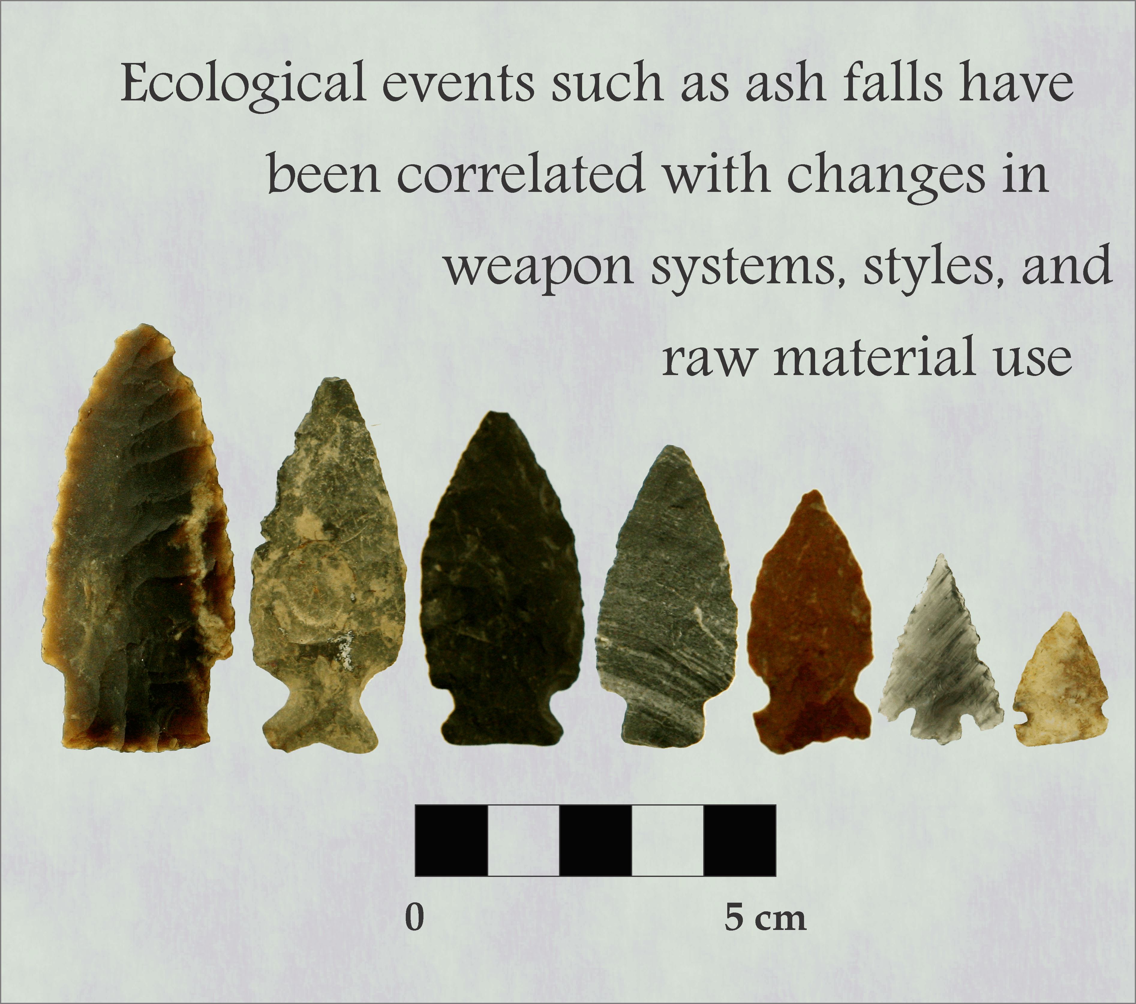
The archaeological record reveals that portions of the province were abandoned for several decades and possibly much longer. Notable changes in weapons and raw materials that were used for stone tools around the time of the Mazama eruption may be linked to this ecological catastrophe; the people that returned to once-vacated landscapes were either different from their predecessors or they arrived with new ideas acquired from their neighbours. This, and other large-scale eruptions in North America over the past 10 000 years, changed the direction of local human histories. New cultures, technologies, and social networks emerged after volcanic events.
Despite the dramatic nature of volcanic eruptions, few people realize that Alberta has experienced them in the past and that other ecological catastrophes have influenced the development of Alberta’s past cultures. Palaeoenvironmental scientists and archaeologists have learned a great deal about past ecological events that, while educational, have more profound implications for the way we manage ecosystems and respond to the world around us. By studying the past, we can learn how to brace for the future.
To learn more about the Mazama eruption and other palaeoenvironmental studies in Alberta, visit some of Dr. Alwynne Beaudoin’s research at the Royal Alberta Museum.
Stay tuned for the next installation of the Heritage Art Series, which will discuss the archaeological and historical records of First Nations fishing in Northern Alberta.
Written by: Todd Kristensen, Northern Archaeologist & Alwynne Beaudoin, Royal Alberta Museum.
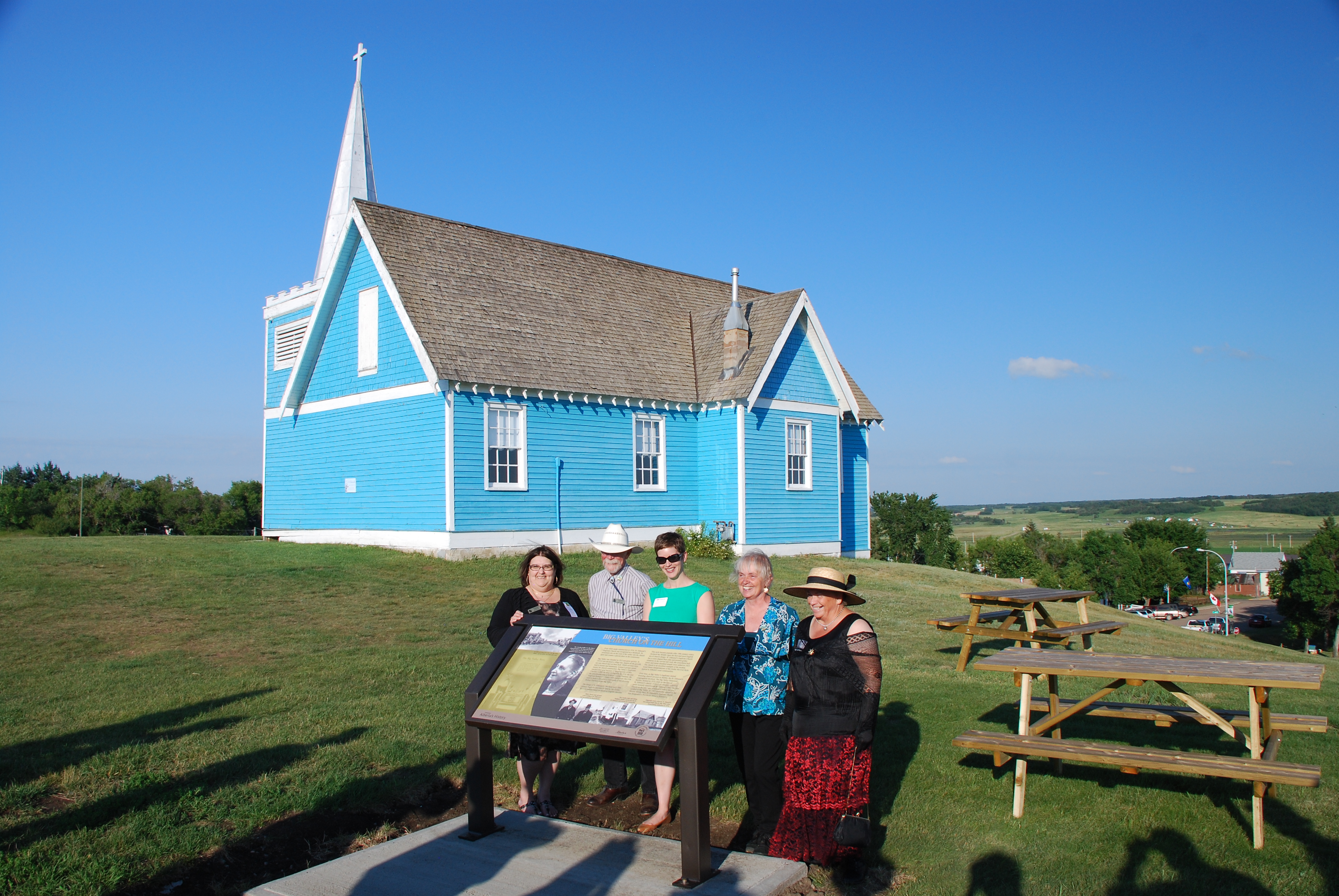
On Friday, August 1, 2014 another heritage maker was unveiled to join the family of over 70 provincial markers located throughout Alberta. Situated in Big Valley, the heritage marker profiles the early history and architectural significance of a prominent local landmark – the St. Edmund’s Anglican Church.
The unveiling of the St. Edmund’s heritage marker coincided with the Big Valley centennial and homecoming celebrations that took place August 1 – 3, 2014. L to R: Gail Knudson, Mayor of Big Valley; Asaph Johnson, Village Councillor; Brenda Manweiler, Historic Places Research and Designation; Lois Miller, Village Councillor and Director, Big Valley Historical Society; Trudy Spence, Secretary, Big Valley Historical Society
St. Edmund’s, valued by residents of Big Valley as an important part of their heritage, was constructed in 1916 through local donations and a $500 contribution from English citizen Caroline Leffler. Leffler offered the donation to the Bishop of the Anglican Diocese of Calgary to establish a church in an area of his choice. Big Valley was selected and the church was constructed on the crest of the valley, visible from miles away. Still today, St. Edmund’s Anglican Church stands as a significant community landmark.
In 2002 St. Edmund’s was designated a Provincial Historic Resource for its associations with the town’s history as a railway boomtown and as a very good example of modest Gothic Revival architecture. St. Edmund’s was first painted blue in 1974 for Big Valley’s initial homecoming – 40 years ago!
The Big Valley Historical Society applied for the development of the heritage marker through the Alberta Heritage Markers Program, which is funded by the Alberta Historical Resources Foundation. Historical society members and local residents are excited about the heritage marker as it will help to celebrate the provincial significance of the church and increase awareness for this important historic place.
The Alberta Heritage Markers Program promotes greater awareness of the historic people, places, events, and themes that have defined the character of our province. The program brings Alberta’s dynamic history alive through heritage markers placed at roadside pullouts, within parks, and in other community locales.
On August 4th, 1914 the United Kingdom declared war on Germany on behalf of the British Empire, including Canada. The First World War had begun. 2014 marks the centenary of Canada’s (and thus Alberta’s) entrance into “The Great War,” a period which tested the province’s strength and demonstrated its resilience. This post will look at recruitment, life in the trenches, conscription and the final 100 days of the First World War.
In August 1914, communities across Canada prepared to serve, organising the people and resources that would be needed to assist the allied forces in victory. Canada was thrust into a situation that required everyone to help the war effort and Albertans responded without hesitation.
Group photo of the 187th Regiment, Canadian Expeditionary Force from Stettler, Alberta. November 18, 1916 (Provincial Archives of Alberta, A5037b)
During the initial stages of the war Albertans were eager to volunteer, and within the first few days men from all over the province had enlisted for military service. Alberta supported the Canadian Expeditionary Force, including 180 cavalrymen from the 19th Alberta Dragoons, more than 400 from the Princess Patricia’s Canadian Light Infantry, 900 members from the 101st Edmonton Militia Regiment and more than 300 hundred men from the 103rd Calgary Rifles Regiment. By 1916, 24 battalions had been raised in Alberta, consisting of approximately 1,000 men each.
Reaching the trenches, the enthusiasm that volunteer soldiers felt upon enlistment quickly wore off. It became obvious to the men that they had been given inadequate training and the weapons they were issued, particularly the Ross Rifle, proved to be ill-suited for trench warfare. As soon as soldiers reached the trenches, they were met with deplorable conditions: vermin, rain, mud and disease were common and the horror of seeing friends and countrymen suddenly killed or maimed became a weirdly familiar experience. The letters that soldiers sent to friends and relatives back home, although often censored, detailed some of their experiences, but it was impossible to describe the realities of being in the middle of a war zone to civilians. One soldier, Private Maus, stated during correspondence with his uncle in Edmonton: “It is a rather muddy picnic, with fireworks free.” This illustrates Private Maus’ wry sense of humour, but also alludes to the dirty conditions and the never-ending noise of artillery fire that were commonplace. Men from Alberta served alongside other Canadians throughout four years of trench warfare.
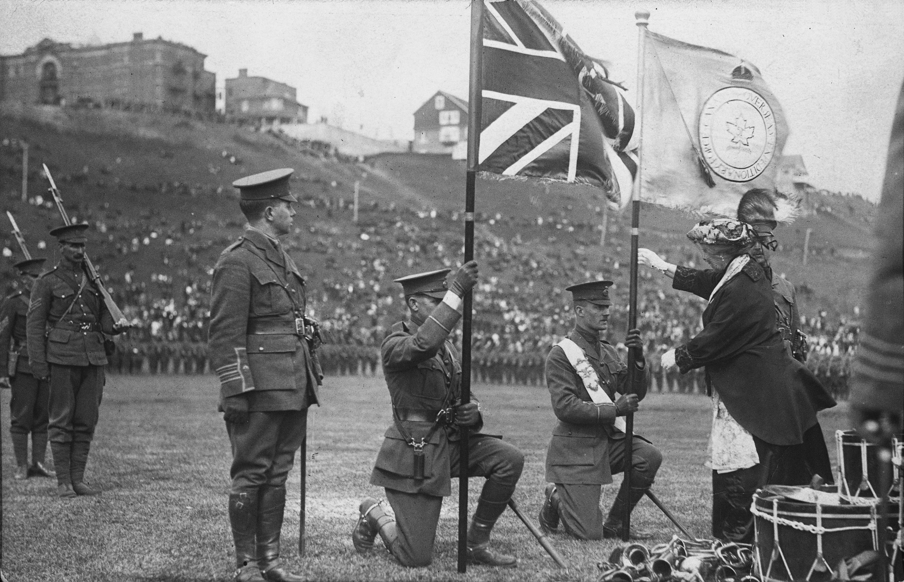
Presentation of Colours to the 51st Battalion, Canadian Expeditionary Force in Edmonton, Alberta, ca. 1915 (Provincial Archives of Alberta, A2526)
A number of men enlisted for military service with the hope of fighting alongside their friends, relatives and neighbour, but very few of the battalions remained together. Units were regularly disbanded and their members reassigned to reinforce other battalions that had been depleted as a result of casualties. Only four battalions from Alberta remained intact and they fought in the front line at second battle of Ypres, the Somme, Vimy Ridge and Passchendaele. They were the 50th battalion from Calgary; the 49th from Edmonton; the 31st, comprised of recruits from southern Alberta; as well as the 10th which recruited members from Calgary and Winnipeg. In total, around 49,000 men from Alberta enlisted as soldiers in infantry, artillery battery operators, field hospital workers, aircraft crews, as well as other equally important areas.
The strong number of volunteers who were initially eager to take on the duties of war had declined sharply by 1917. Once word had reached the home front about the death toll that accompanied war service, recruitment became a challenge. Prime Minister Robert Borden and his cabinet nevertheless felt a duty to maintain its front line ranks and, with the lack of new and willing recruits, talk of conscripting able bodied men into military service began. Borden had seen firsthand the toll Canadian soldiers paid while visiting hospitals in England and the battlefront in France.[1] As a result, Borden pushed a conscription bill through Parliament, despite strong opposition, and mandatory enlistment was made law on August 28, 1917.
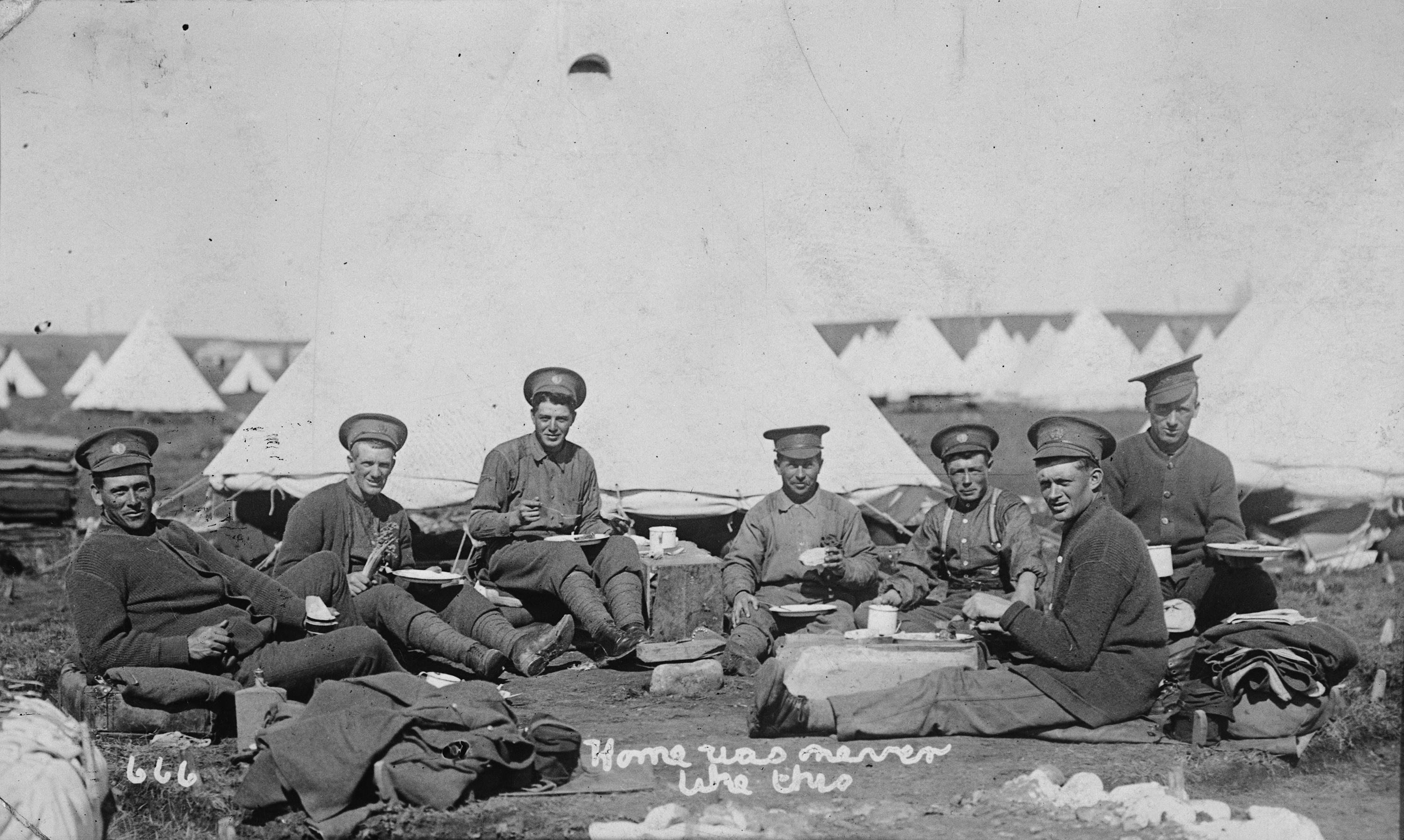
Len Foster and other soldiers overseas during the First World War, ca. 1916 (Provincial Archives of Alberta, A6741)
All eligible men were instructed to immediately sign up for military service. This included men who were unmarried or childless widowers between the ages of 20 and 34, although there were other exemptions. War-time workers who were deemed essential to the war effort and conscientious objectors were a few of the exceptions that men could apply for. In Calgary, 11,953 males requested exemption and 60% of Alberta’s conscripts who registered in Edmonton were deemed unfit to send to war. Conscription was passed with the intention of enlisting 70,000 new recruits from across Canada, but approximately 26,000 were sent to Europe. This was far less than Borden’s goal.
The final 100 days before the armistice were among the darkest, with Canadians fighting in a series of bloody battles in France. The Amiens campaign began on the foggy morning of August 8, 1918, when Canadian soldiers, along with the British, Australian and French forces, pushed through German defences within the first day. Albertans in the 10th battalion of the Canadian Expeditionary Force made significant advances, being the first to reach their offensive objective and they were soon followed by the 31st battalion. The Canadian forces forged ahead and up next was the region of Arras, where a large numbers of German defenses still remained. The battalions that had been raised in Alberta remained on the front line during the attack and assisted in taking control of the Drocourt-Quéant Line. This was a significant breakthrough for the allied forces in progressing towards the German border. What followed was a series of campaigns that showed the Canadians as a vital fighting force, and victory was claimed again in the subsequent, major battles of Canal du Nord, Cambrai and Valenciennes. Throughout these conflicts, the battalions made up of Albertans remained at the forefront of the action until the very end, with the liberation of Mons, Belgium. After years of violence, armistice was declared on November 11, 1918, and the conclusion of the war brought a mixture of shock and relief to Alberta’s soldiers.
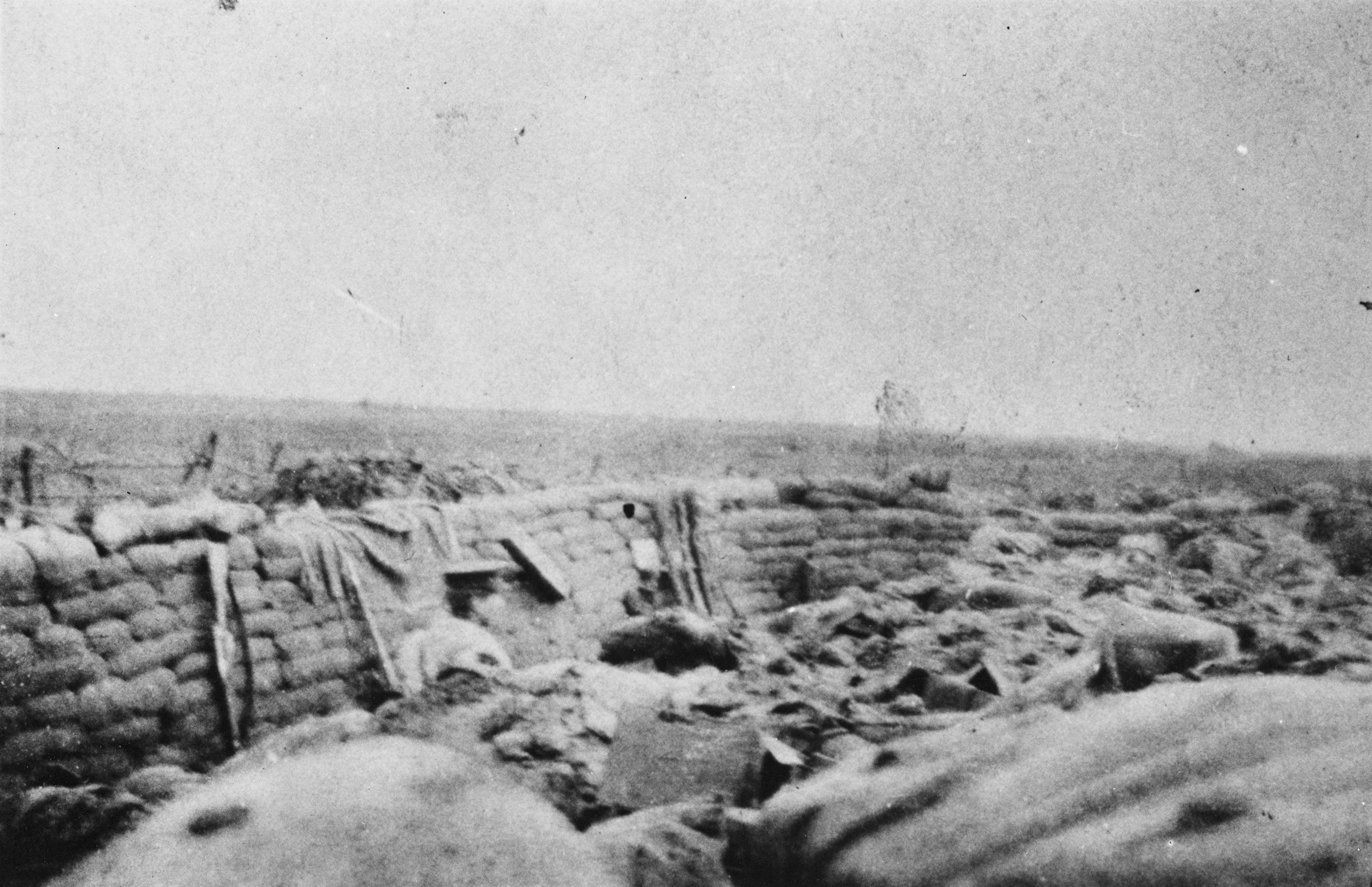
Trenches in France during the First World War (Provincial Archives of Alberta, A9020)
Alberta paid the price for their involvement, with approximately 6,140 men killed and another 20,000 wounded. One in eight of those who enlisted never came back. The casualties of war were felt across the province. From the town of Gleichen, 250 men were deployed to fight and one in five of those soldiers lost their lives. Edmonton’s 49th battalion alone recorded approximately 1,000 losses, enough to assemble an entire battalion. In February of 1919, war veterans gradually began to return home, but the province had changed as a result of the First World War. Sacrifices were made by those who fought in the war as well as the by people who remained on the home front. From the social impact to the human toll, life in the province was altered for Alberta’s people in subsequent generations.
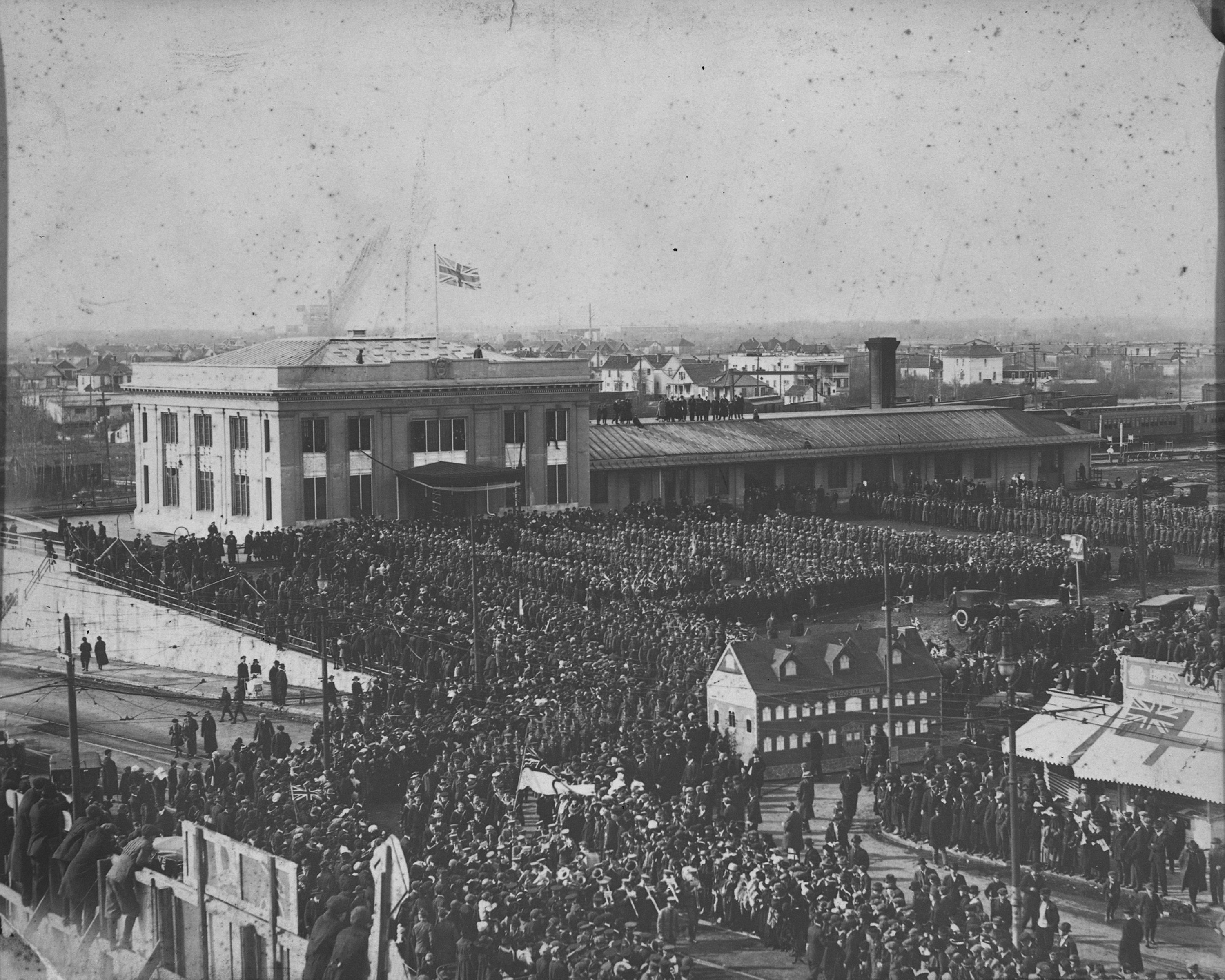
Soldiers in the 49th Battalion return to Edmonton, Alberta from Europe after the end of the First World War. March 22, 1919 (Provincial Archives of Alberta, A18513)
For more information on Alberta in the First World War, refer to Alberta in the 20th Century: The Great War and its Consequences 1914-1920 or Alberta Formed Alberta Transformed. The Great War: 1914-1918 features a number of editorials that are specific to Alberta.
This was the first part of a series commemorating the First World War. Over the next month, this series will look at a range of topics that will show Alberta’s involvement in this historic event.
Written by: Erin Hoar, Historic Resources Management Branch Officer.
Sources
Blue, John. Alberta: Past and Present. Vol. 1. Chicago: Pioneer Historical Publishing Co., 1924.
Byfield, Ted, ed. Alberta in the 20th Century: The Great War and its Consequences 1914-1920. Vol. 4. Edmonton, Canada: CanMedia Inc., 1995.
Love, David W. A Nation in Making: The Organization and Administration of the Canadian Military During the First World War. Vol. 1. Ottawa: Service Publications, 2012.
Payne, Michael, Donald Wetherell, and Catherine Cavanaugh, eds. Alberta Formed Alberta Transformed. Vol. 2. Edmonton, Canada: University of Alberta Press, 2006.
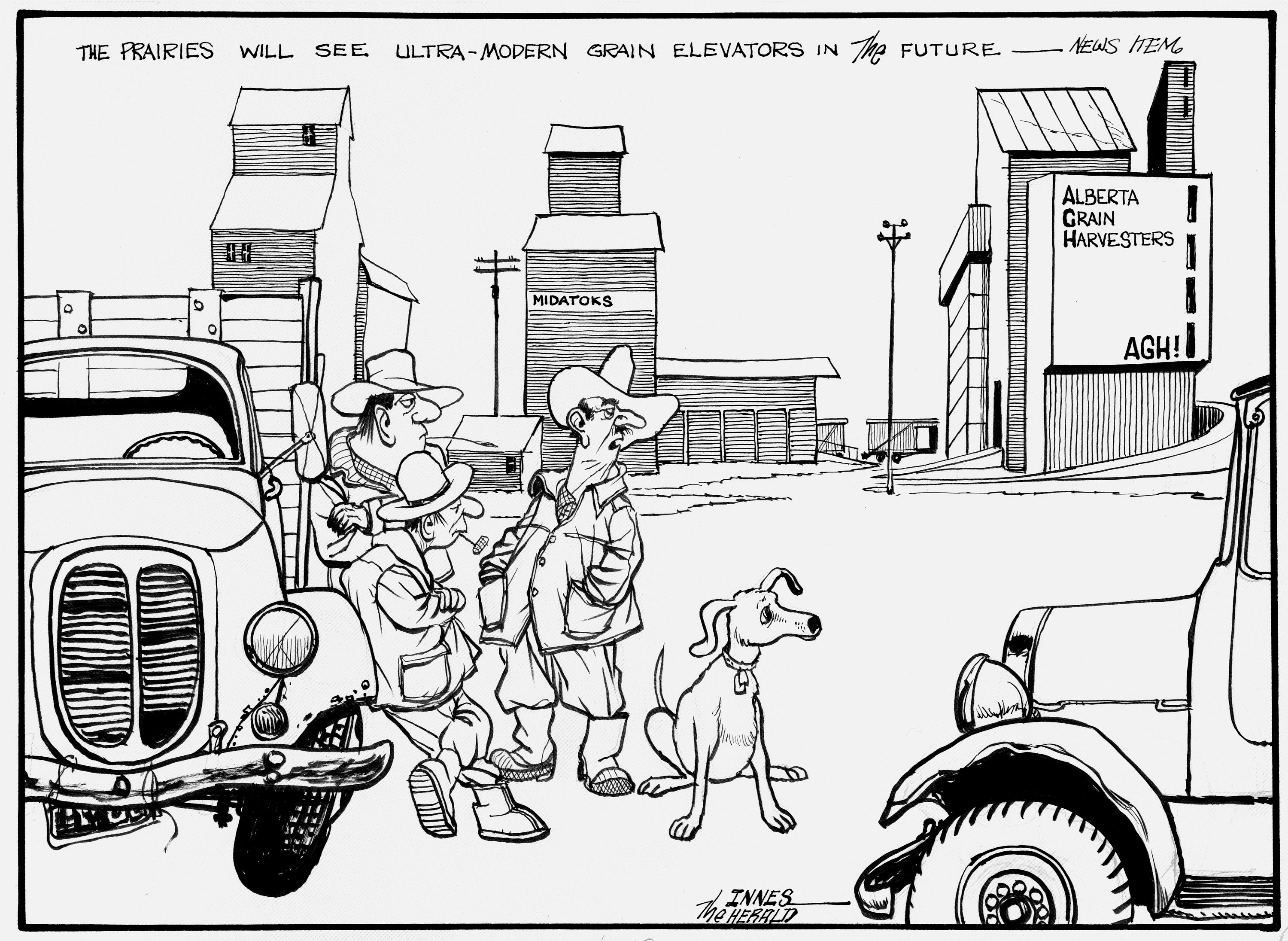
As this cartoon indicates some farmers were skeptical of the Buffalo design. (Courtesy of Glenbow Archives, M-800-344.)
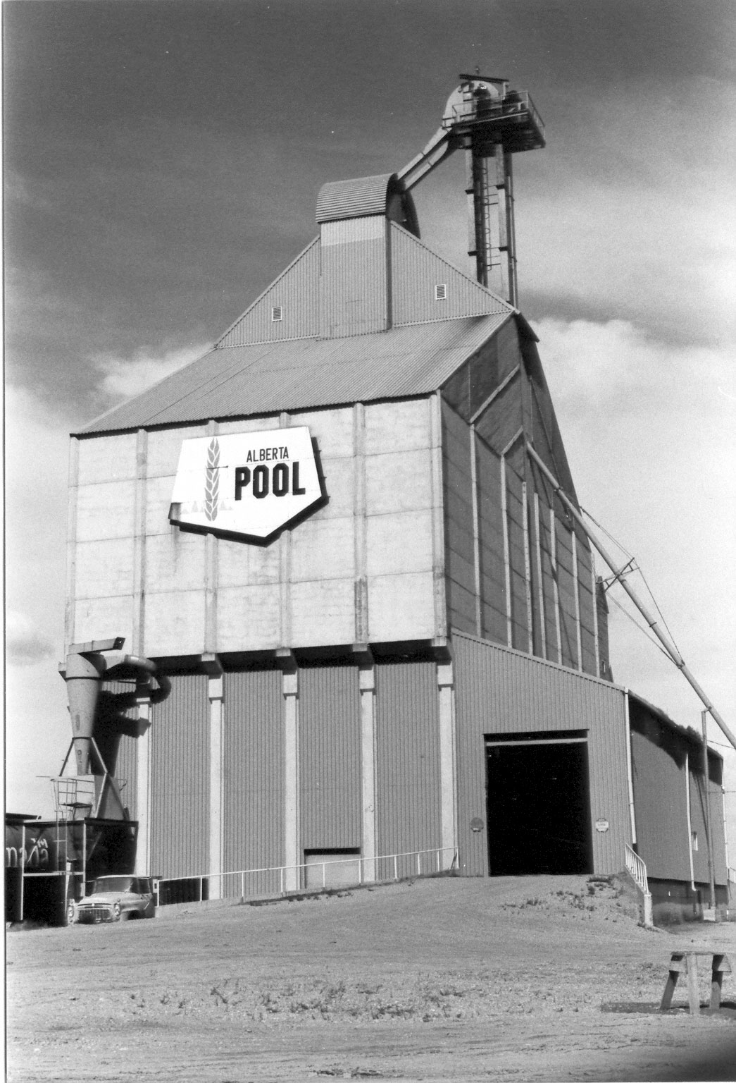
Not long ago, Alberta, had country grain elevators named for the indigenous bison that roamed the plains before grain was grown. The innovative Buffalo, as they were called, were designed in Alberta, and constructed in both Alberta and Brazil. In the late 1970s times were good for Alberta’s farmers and their grain Company—the Alberta Wheat Pool. Bumper crops and high grain prices kept the grain elevators humming. As fires destroyed many wood elevators, and the railways were pushing for ever more streamlined grain handling, the Pool decided to use some of its profits to experiment with concrete country elevator designs. It began working with Buffalo Engineering of Edmonton, headed by Klaus U. Drieger. This resulted in a partnership company ABL Engineering Ltd. to produce a design for an elevator that was radically different, and formed a second company, Buffalo Beton Ltd. of Calgary to construct them.
The first design was the trapezoidal Buffalo 1000, colloquially named the Buffalo Slope. In a complete departure from traditional wood-crib elevator design, this elevator was built up using 42 square pre-cast concrete modules, stacked like cord wood at a thirty degrees angle from the ground. The elevator could hold 206,000 bushels. The first was built at Magrath in 1979 and opened with huge fanfare—the festivities included a community band and farmer tours of the facility. Two more Buffalo Slopes were erected in 1981, at Vegreville and Fort Saskatchewan. The Buffalo Slope design worked well with some grains, but the 30 degrees slope was inadequate for barley and oats to slide out the bottom of the module and the complicated conveyor systems were high maintenance. Faced with less than stellar reviews, ABL Engineering went back to the drawing board.
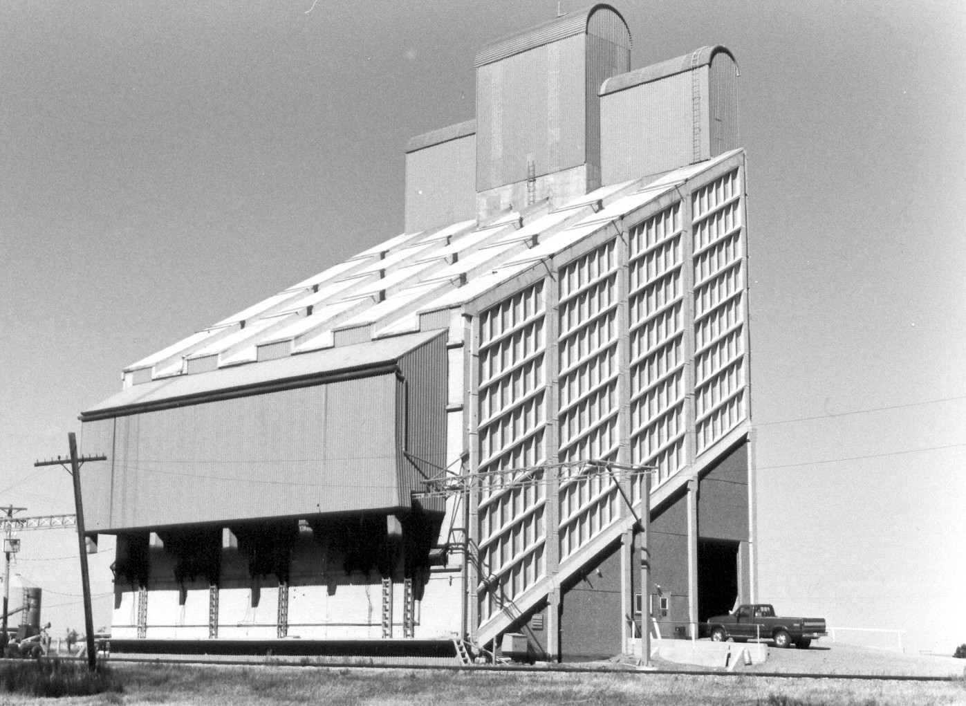
Buffalo Elevator at Magrath in 1997. (Courtesy Alberta Heritage Survey, 97-R0293-17A.)
The second design, the Buffalo 2000, was also constructed with precast panels in conjunction with poured-in-place concrete, although it had a more conventional shape. The elevator has vertical bins with hopped bottoms, fashioned with precast bin floors and cast-in-place concrete bin walls. The Buffalo 2000 holds about 190,000 bushels in thirty bins. The Alberta Wheat Pool built two of these, at Lyalta in 1982 and at Foremost in 1983. These fireproof elevators worked well, but were expensive. The Pool built nine cheaper wood-cribbed double-composite elevators next, the last one at Dapp in 1985. Then in 1986 a final Buffalo 2000 was built at Boyle, a year before the Buffalo consortium folded.
Ironically, the futuristic Buffalo designs were obsolete soon after they were built as the era of the country elevator was over. After 1995 all the grain companies built slip-form concrete silo elevators. These were high capacity high-throughput regional terminal elevators designed to collect grain from hundreds of kilometers around. They were located on spur lines able to handle 52 or 104 car trains. The buffalo, built on railway sidings without sufficient space to load many cars, were too slow for high throughput: a Buffalo could load a grain car in thirty minutes while the new terminal elevators could load one in six to seven minutes. The days of the country elevator were numbered, whether wood-crib or concrete Buffalos. As the wood-crib elevators, even new ones, were demolished, the concrete Buffalo, despite not being used by the grain companies, proved to be survivors as they passed to individual farmer groups. The Canada Malting Company buys and stores malt barley in the Buffalo 2000 at Lyalta. Two were recently demolished: the Buffalo slope at Vegreville and the Buffalo 2000 at Boyle.
Buffalo Elevator at Lyalta in 1997. (Courtesy Alberta Heritage Survey, 97-R0248-17.)
The Buffalo design also survives in Brazil. The Buffalo engineering team designed the huge Buffalo 4000 that was constructed from precast concrete modules to build up bins in a double V pattern. Several of these inland terminals with a capacity ranging from 25,000 tonnes (957, 500 bushels) to 100,000 tonnes (3,750,000 bushels) were constructed in Brazil during the early 1980s. A 25,000 facility was located in Brasilia and another in Campo Grande, Mato Grosso del Sul in central-west Brazil. In the state of Minas Gervais in the west part of the country, where wheat and soy beans are among the main crops, a massive 100,000 tonne Buffalo 4000 was constructed at Uberlandia. The Buffalos of Brazil, where sixty-percent of grain is moved by truck, remain an international monument to Alberta engineering innovation.
The August long weekend is fast approaching. Before we know it Heritage Day – Monday, August 4 – will be upon us. If you are wondering what to do with your day off, why not consider a heritage-themed outing? This is the perfect time of year to explore Alberta’s rural historic resources.
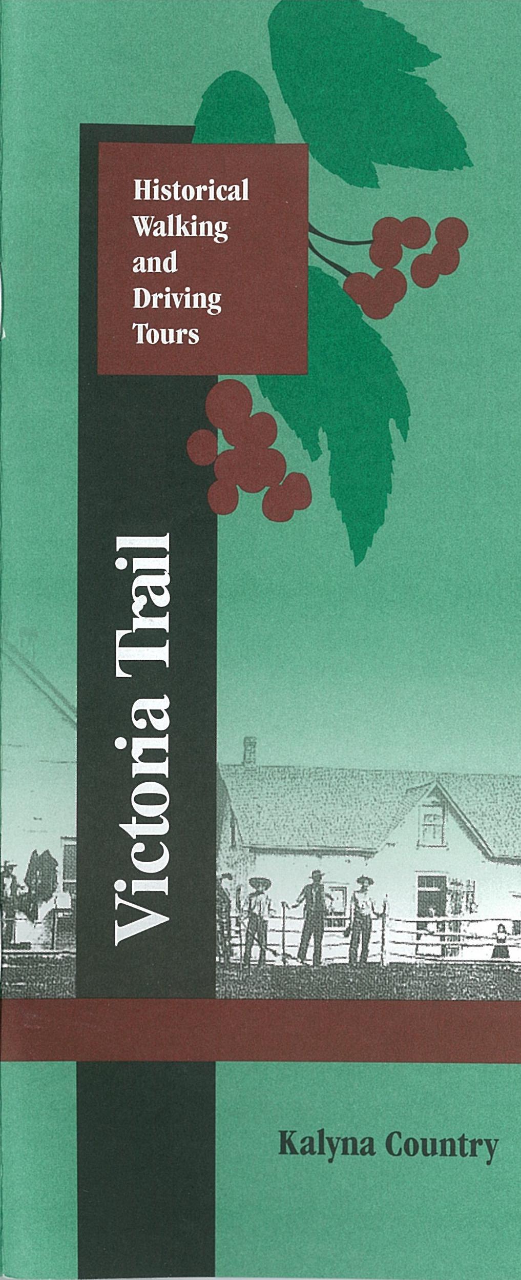
The cover of the Victoria Trail Historical Walking and Driving Tours booklet.
If you are in the Edmonton area, an ideal destination for a heritage day trip is the Victoria Settlement Provincial Historic Site, located one hour and forty minutes northeast of the city. It is a perfect location for a picnic, and there’s plenty to see there. Before you head out of town, make sure you download or print out the Victoria Trail Historical Walking and Driving Tours booklet that is available on the Alberta Culture website. It contains information about the buildings at the settlement, and, once you’ve finished exploring the historic site, you can follow the tour back towards Edmonton along the historic Victoria Trail.
There are two Provincial Historic Resources at the Victoria Settlement Historic Site: Fort Victoria, a Hudson’s Bay Company building dating from the 1860s, and the 1882 Free Trader’s Cabin on River Lot #3. In addition, you can see the Reverend McDougall Graves, where four of the missionary’s family members – victims of an epidemic of smallpox in the 1870s – are buried. A 1906 Methodist Church on the site recalls the important role of the church in the settlement of the area.
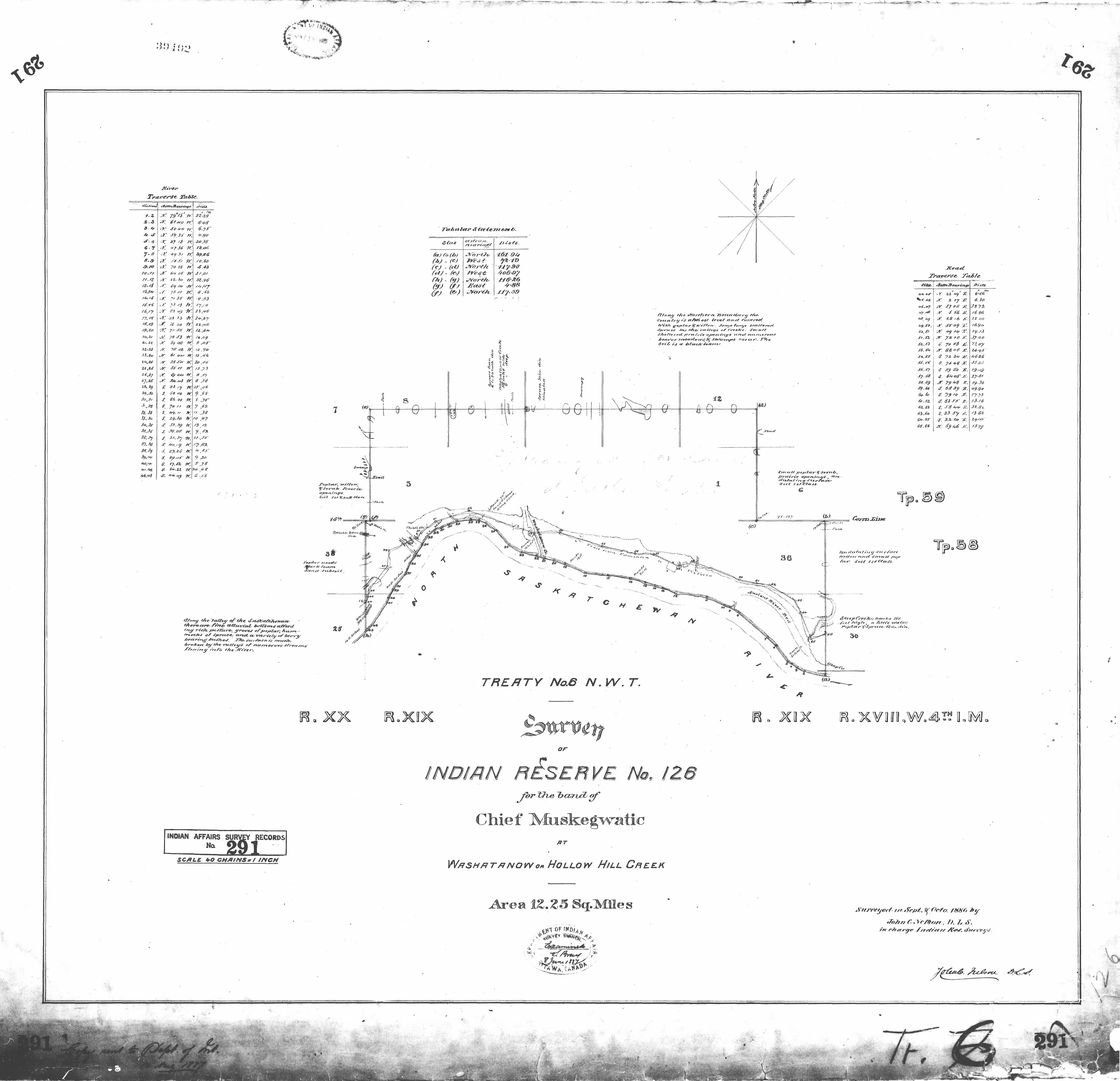
This plan of Indian Reserve No. 126 shows the Victoria Trail as it follows a curve in the North Saskatchewan River. (NCR 291)
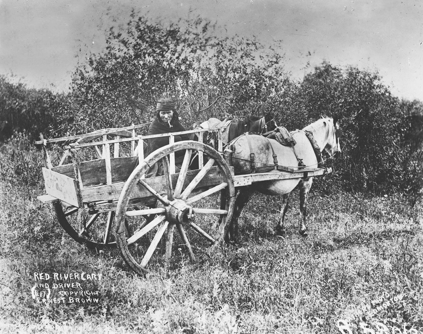
The Victoria Trail is a scenic drive that winds along the bank of the North Saskatchewan River. Unlike many other historic routes, it has remained largely undeveloped and evocative of days gone by. As you traverse the Victoria Trail, it is easy to imagine yourself in the company of those who came before. After 1860, convoys of Red River carts carrying supplies to Edmonton wore ruts into the sod. In 1874, the first North-West Mounted Police contingent famously trekked west along the trail. After the turn of the century, traffic flowed the other way, with Ukrainian settlers coming east from Edmonton to settle on the land. Until the coming of the railway in 1918, the Victoria Trail remained the most important overland route linking Edmonton the Victoria Settlement.
Red River carts like this one were a common sight on the Victoria Trail in the 1860s. (PAA B5806)
This Heritage Day, treat yourself to a journey back in time, along the Victoria Trail.
Written by: Dorothy Field, Coordinator, Heritage Survey Program
The Historic Resources Management Branch of Alberta Culture is pleased to announce the launch of the Alberta Energy Resources Heritage website. The site was developed with the aim of promoting an understanding and appreciation of the Province’s abundant energy resources, the rich history of resource extraction and production, and the important role that this sector has played and continues to play in Alberta’s social, political and economic history.
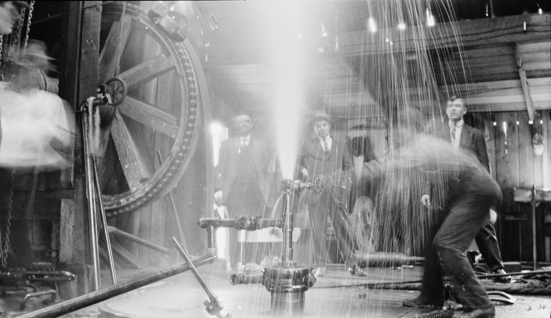
Turner Valley Discovery Well Blowing, 1914. (Provincial Archives of Alberta, P1883.)
As the homepage of the website points out:
“Ancient forces shaped Alberta’s geology, creating a land rich in energy resources. Yet, the story of energy in this province goes well beyond geological formations or petroleum chemistry. It is also the story of individuals, of people driven to reveal the province’s energy secrets and unlock the power of its resources. The quest to locate and unlock Alberta’s energy potential began with them—with their persistence, their innovative thinking and even their passion. It was their energy as much as any other that transformed Alberta, economically, socially and politically.”
Five areas of Alberta’s resource development are explored in detail: coal, conventional oil, natural gas, electricity and alternative energy and the oil sands. Also profiled is Bitumount, north of Fort McMurray where the earliest scientific research on industrial oil sands extraction took place. This pioneering work would later transform Alberta into a major player in the global energy market.
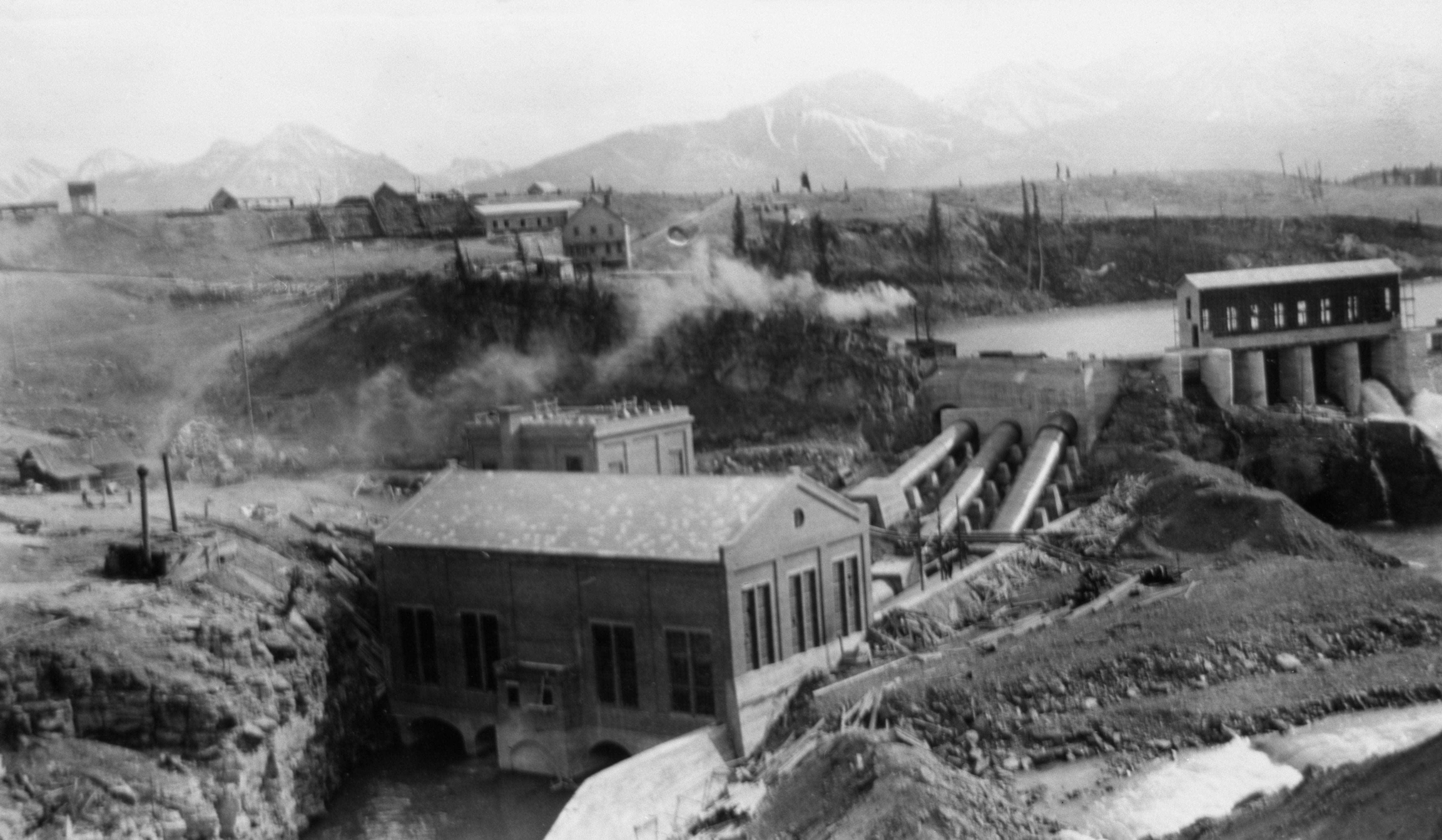
Calgary Power’s power house at Horseshoe Falls on the Bow River, ca. 1912 (Glenbow Archives, NA-3544-28.)
The website is intended to be informative and comprehensive, offering insights into the geological formation of resources, the ancient uses of various energy resources and exploration and industrialization within Alberta. Energy resources are examined through over 300 thematic entries, covered in more than 600 pages of text. Hundreds of archival images, charts, maps, and documents as well as dozens of videos augment the text as do extensive technical glossaries and lists of documentary sources. In addition to exploring the earliest and evolving histories of these sectors the site offers special insights into Alberta’s social history ranging from the miners of the Crowsnest Pass through to the rough necks of the Oil Patch, to pioneering proponents of alternative solutions for the province’s ongoing energy requirements.
Educators, students and the general public are invited to visit the website and explore its various components.