Hooves in History: How the Horse Changed the West

This post continues our look at the work of Alberta’s Archaeological Survey. Previously, we explored “10, 000 years of hunting in Alberta“, as shown in the archaeological record. While RETROactive will continue to be your source for news and information about Alberta’s historic places, we are branching out to provide insights into other aspects of our work to understand, protect and conserve historic resources.

The chronological spread of the domestic horse into Alberta over the last 500 years.

When horses galloped across what would become the US border onto Alberta’s rolling prairies in the 1720s, it was a bit of an overdue homecoming. It had been roughly 10,000 years since the province’s expansive grasslands shuddered under hard equestrian hooves. Fossils indicate that North America is the original home of the horse where it first appeared millions of years ago.

Ancient spear from Alberta that was coated in blood of the now-extinct Mexican horse.

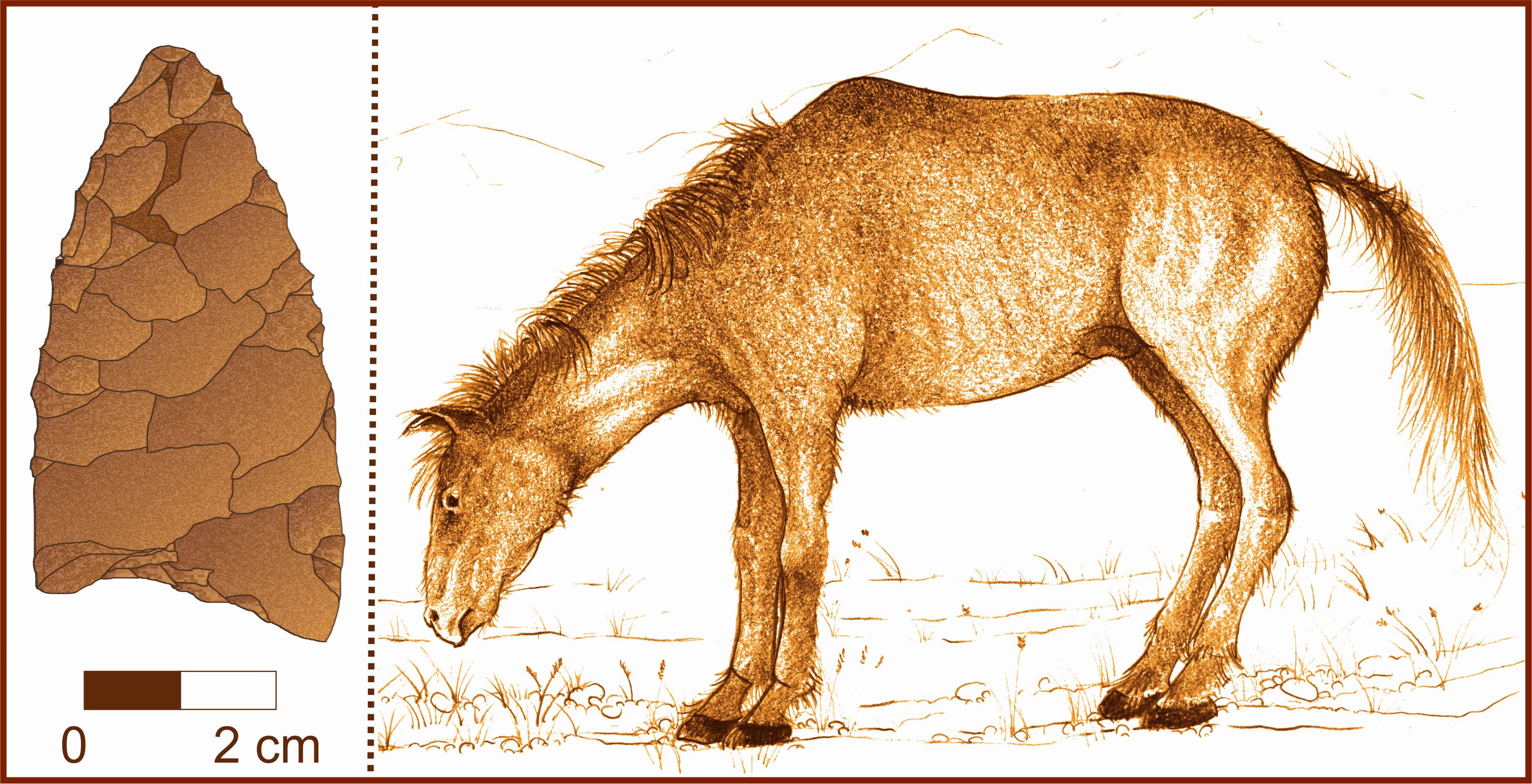
The now-extinct Mexican horse (Equus conversidens) ventured well north into Alberta’s tundra meadows and onto the menu of Alberta’s first humans. Ancient residues of horse blood were found on stone spear tips used over 10,000 years ago in southern Alberta. Fossil horse bones have also been found near Grande Prairie, Taber, Cochrane, and in the Edmonton area. Around 10 millennia ago, the horse mysteriously disappeared. When the horse returned with the Spanish 500 years ago it assumed a central role among Indigenous and European cultures in the West. The story of the horse in Alberta is a fascinating ride through the province’s heritage.

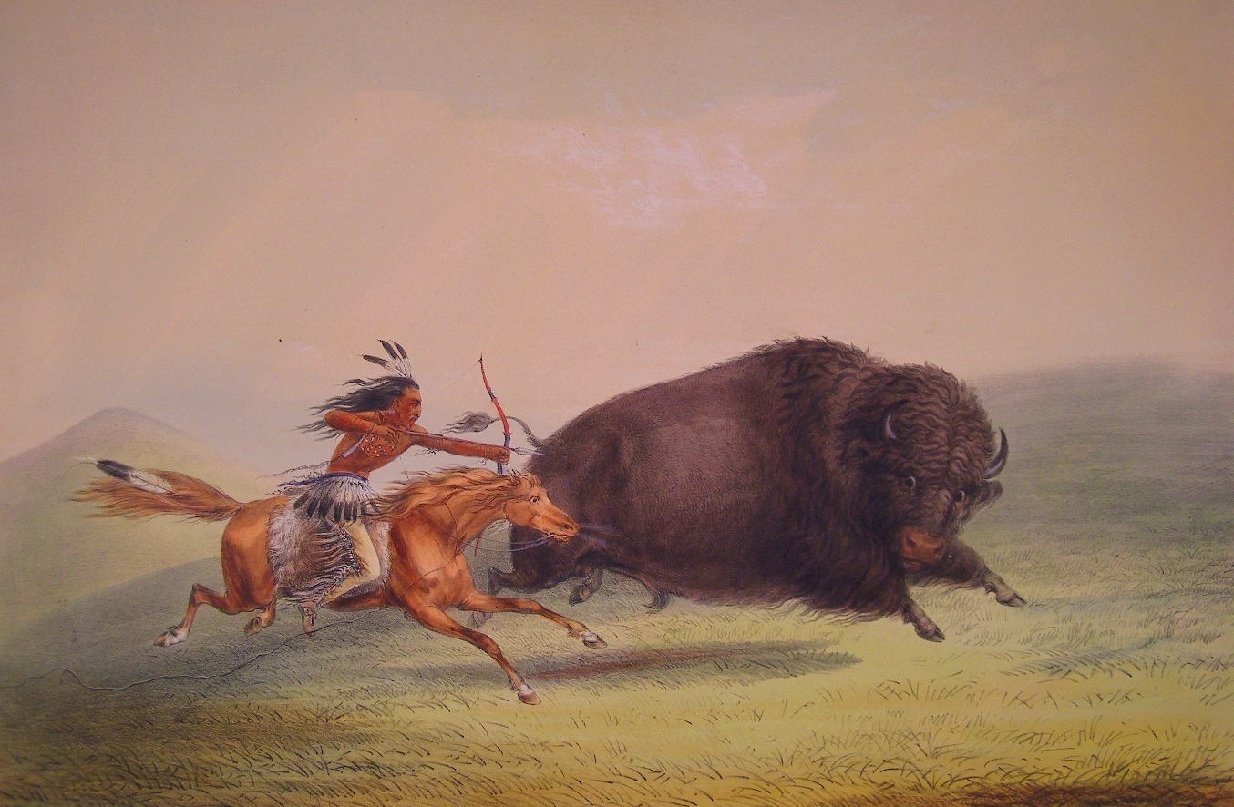
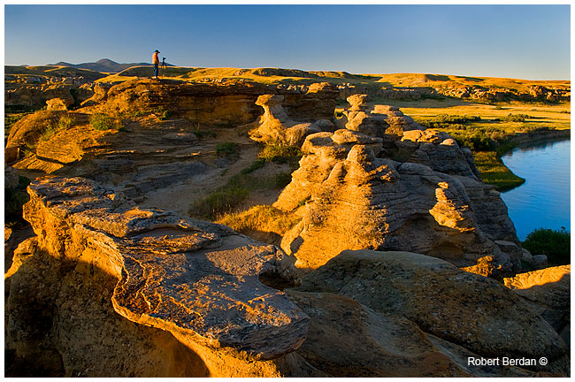
Once groups like the Blackfoot and Assiniboine mastered horseback riding, the horse occupied just about every dimension of life on the Plains. The new hooved pets created new hunting strategies, they changed the way people moved across the prairies, and they altered the dynamics of Plains warfare but reconstructing when and how the domestic horse spread into Alberta has been tricky. Historic records offer only a handful of references to horse adoption by Indigenous people but a unique piece of heritage offers fleeting and beautiful glimpses of how the horse changed the West. Writing-on-Stone Provincial Park in southern Alberta houses one of the largest collections of rock art in North America. For over a thousand years Indigenous people carved and painted their stories on the sandstone hoodoos and canyon walls and the horse looms large in those depictions.

This carving (‘petroglyph’) from Writing-on-Stone depicts a domestic horse in a buffalo hunt.

Horse carvings depict a wide variety of events and beliefs including battle scenes, hunting expeditions, and tallies of horses acquired through trading or raiding. In everyday life, some horses replaced the dog as beasts of burden while other horses were highly revered as ‘buffalo runners’, prized for being long-winded and intelligent while overcoming an 800 pound buffalo. For buffalo hunters who needed both hands free for their weapons, a well trained horse was a matter of survival.

A painting by George Catlin from the 1800s of life on the Canadian Plains (reproduced with permission from the Bruce Peel Special Collections Library, University of Alberta).

The horse also quickly galloped into peoples’ social lives. Families that acquired many horses gained prestige and respect. Horse raiding became a mark of courage for many groups and horses were traded for a multitude of things including European goods, food, membership into societies, and spiritual power. During the fur trade while slick beaver furs were motivating European economic interests in northern Alberta, horses, guns, and buffalo meat were becoming entwined in complex trade networks that would shape the history of the prairies. When the buffalo eventually vanished, the hooves of the horse pounded on.

This combat scene from Writing-on-Stone shows an early horse draped with body armour (photograph reproduced with permission from Michal Klassen).

The unique collection of rock art at Writing-on-Stone is a provincial treasure that captures pivotal centuries of modern Plains cultures. For this reason, the area is both a Provincial Historic Resource and a National Historic Site. Writing-on-Stone is still a sacred place to the Blackfoot people; a place where spirits dwell among the sculpted bedrock. Visitors are encouraged to learn the story of this powerful place. One of the many benefits of the stony archive of art on the Milk River is that it can be enjoyed and appreciated under blue skies.

Morning light on the beautiful hoodoos at Writing-on-Stone (photograph reproduced with permission from Robert Berdan).

What better way to learn how the horse changed the west than from reading the walls of Writing-on-Stone while cool breezes blow in hints of sage and a red-tailed hawk reads over your shoulder? Site protection combined with a healthy respect for Blackfoot traditions and the archaeological record will ensure that the history of the old West will endure and the story of the horse will ride on.

Written by: Todd Kristensen, Northern Archaeologist & Jack Brink, Curator of Archaeology, Royal Alberta Museum.

Big Game in Deep Time: 10,000 years of Hunting in Alberta

RETROactive has been publishing for almost three years now. We will continue to be your source for news and information about Alberta’s historic places.

At the same time, we’re going to start bringing you articles providing insight into other aspects of Alberta Culture’s work to understand, protect and conserve historic resources. This post is the first showcasing the work of Alberta’s Archaeological Survey.

By the time Europeans and their guns arrived, 250 years ago, in the place that would become Alberta, the area had already witnessed 10,000 years of big game hunting. Alberta’s prehistoric hunters killed mammoth, an extinct horse, an over-sized species of extinct bison, and even camels that roamed the plains millennia ago (Figure 1). Analyses of stone tools have revealed traces of mammoth and horse blood on spear tips in northeast Alberta and southwest of Lethbridge, respectively. Other evidence of prehistoric big game hunting includes human-made cut marks on animal bones found with stone tools.

A selection of wildlife that greeted Alberta’s hunters 10,000 years ago.
Figure 1:  A selection of wildlife that greeted Alberta’s hunters 10,000 years ago.

At eight tons and over three meters tall, the woolly mammoth towered over human hunters. So how did people with thrusting spears bag this massive grazer without being gored? Most likely with ingenuity and teamwork. Mammoths, as well as horses and large bison are herd animals that were probably corralled into situations that gave people the upper hand like bogs, canyons, and cliffs where lumbering prey would get trapped or stuck in the mud. In addition to the dangers of hunting big animals, people also had to contend with big predators like the now-extinct American lion, which has been found in Calgary and Edmonton. It was taller than a polar bear (but much faster) and likely kept people on fearful watch.

By 8,000 years ago, Alberta hunters acquired a new weapon that put some distance between themselves and future food: the atlatl (spear thrower) and dart (a short spear). The atlatl enabled people to throw weapons with much greater force (Figure 2).

Hunting technologies in Alberta.
Figure 2:  Hunting technologies in Alberta.

Around 2,500 years ago, stone tips on ancient weapons become much smaller which indicates the arrival of bow and arrow technology. The bow and arrow was effective at about 30 m away (Figure 3) so why adopt a new hunting system that required people to get closer to big game than the older atlatl?

Hunting ranges of Alberta’s ancient weapon systems.
Figure 3:  Hunting ranges of Alberta’s ancient weapon systems.

Imagine wearing a blind-fold on an autumn day and listening to the difference between a stationary archer and a javelin thrower lunging across the dry leaf litter. The bow and arrow was quieter because it required much less movement and it was also more accurate.

Several other hunting technologies existed in addition to spears, darts, and arrows. Bison and pronghorn antelope were stampeded over cliffs and canyons (Figure 4);

Ancient pronghorn hunting trap. The map is of stone drive lanes in Southeast Alberta and the photograph at right is of archaeologists mapping a pronghorn drive lane north of the Red Deer River.
Figure 4:  Ancient pronghorn hunting trap. The map is of stone drive lanes in Southeast Alberta and the photograph at right is of archaeologists mapping a pronghorn drive lane north of the Red Deer River.

Head-Smashed-In Buffalo Jump near Fort Macleod is a world famous example that was used for over 5,000 years. Small piles of stone were built in converging lines creating drive lanes that extended several kilometres. These piles stabilized branches and leather strips that waved in the wind and frightened bison, which were funnelled down the drive lanes and over steep cliffs. Up to 200 animals could be killed in one day. Buffalo jumps are one of the largest prehistoric meat-capturing events on the planet and it happened thousands of times over thousands of years on the rolling prairies of Alberta.

Moose, elk, deer, and caribou were snared, stalked in deep snow, and speared from boats while swimming. In the winter, beaver and bears were speared in dens and lodges. Alberta’s early hunters called game with birchbark horns, rubbed scapulas on trees to imitate antler raking, dressed in coyote skins to more easily approach bison, and regularly burned small areas to stimulate plant growth that attracted big game. Archaeology tells a story of thousands of years of successful big game hunting strategies. While archaeologists have learned a great deal about ancient hunting, much remains to be discovered.

Alberta Culture’s Archaeological Survey maintains records of new archaeological discoveries across the province to enable their protection. If you come across an arrow head or other stone tools, please take a few photographs or jot down some notes to share with us so we can continue to learn about the province’s rich hunting history. You can contact the Archaeological Survey at  780-431-2300.

Written by: Todd Kristensen, Northern Archaeologist & Darryl Bereziuk, Director, Archaeological Survey.

Meet our new Municipal Heritage Services Officer

Hi everybody,

Rebecca G_2013.11.14 (1)My name is Rebecca Goodenough and it is a real pleasure to introduce myself as the newest member of the Historic Places Stewardship team. I have read the bios of Historic Places staff on RETROactive with much interest over the past few years, wondering if (sigh) I might ever have such an amazing job. So it is with much excitement and a lot of humility that I introduce myself as the new Municipal Heritage Services Officer. I look forward to meeting a many of you over the coming months.

Unlike many of my colleagues, I came to the field of heritage conservation more recently and the majority of my education and work experience has been within the world of land use planning. I have worked in both the private and public sectors in British Columbia and Alberta. Most recently, I worked for Strathcona County as a Planner.

My interest in heritage grew from personal curiosity. I read books and took every opportunity to attend a course, lecture, meeting or conference related to heritage. The more I learned, the more I became a believer that heritage conservation is a means to achieving a great many of the long-term goals that planners and other community builders try to achieve through their day-to-day work: sustainable development, building a sense of place, quality in design, local economic development. All of these goals and more I believe are achievable through building a culture of respect for our past.

While with Strathcona County, I was fortunate to have had the opportunity to complete a Professional Specialization Certificate in Heritage Conservation Planning through the University of Victoria. This program provided me with a strong foundation in the principles and practices of the field. I also helped to establish Strathcona County’s heritage program, which included participation with the Municipal Heritage Partnership Program.

I hold degrees in Political Science from the University of Alberta and in Northern and Rural Community Planning from the University of Northern B.C. In my spare time, I enjoy participating in a few activities (at a very pedestrian level) including running, cross-country skiing and playing the piano. And, of course, I am still reading and attending those courses, lectures, meetings and conferences because there is always so much to learn!

I hope to bring my experience working with a range of communities and my understanding of municipal processes to my work with the Municipal Heritage Partnership Program and Alberta Main Street programs. More importantly, I look forward to meeting all you advocates for local heritage out there and hearing about the significant places in your communities.

Written by: Rebecca Goodenough, Municipal Heritage Services Officer.

Lacombe wins the Great Places in Canada competition!

Lacombe’s Historic Main Street named Best Street in Canada.

The City of Lacombe’s historic main street was just named Best Street by the Great Places in Canada competition. The Great Places in Canada competition is sponsored by the Canadian Institute of Planners, annually. Lacombe’s Historic Main Street was shortlisted in the Best Street category by popular vote. It was then selected as the winner by a panel of experts from the Canadian Institute of Planners. We’re thrilled that one of Alberta’s historic main streets has received national recognition.

A photo showing a block of 50th Avenue in Lacombe.
a block of 50th Avenue in Lacombe (2009)

You may recognise Lacombe’s main street—50th Avenue in Lacombe is one of Alberta’s iconic streetscapes. Most buildings in downtown Lacombe were constructed in the decade before the First World War. A building bylaw, aimed at limiting the destruction that a fire could bring, required that anything built in the downtown be constructed of brick. Many of the Edwardian-styled commercial buildings—such as the Flat Iron Building—are Alberta icons. Several of the buildings, such as the Flat Iron Building, the M & J Hardware Building and the Campbell Block are Provincial Historic Resources.

These landmarks would most likely have been lost if not for the foresight and dedication of Lacombe’s citizens. The owners of these gems took a great deal of pride undertaking the conservation work often needed. Lacombe’s forward-looking business community was an early participant in the Main Street Program (from 1987 to 1993). The rehabilitation work undertaken during this time is an important reason why so many of these buildings remain standing.

The city has since developed policies to ensure that conservation of its historic commercial district is an important part of its’ development process. The city recently completed both a Downtown Area Redevelopment and Urban Design Plan—which features detailed plans for maintaining the streetscape. The city also recently adopted a Heritage Management Plan (with the help of the Municipal Heritage Partnership Program) ensuring that locally significant historic places are inventoried and can be designated as Municipal Historic Resources.

What is really fitting about this award is how it recognises the community’s involvement in these special places. 50th Avenue is not a museum piece, but a destination people go to meet friends, shop and celebrate. This is a lively area with many restaurants and businesses. The Lacombe and District Historical Society operate a museum on the main floor of the Flat Iron Building. Social service agencies and the provincial government have offices on the street or nearby. Popular annual events—the Light Up the Night Festival, the Lacombe Culture and Harvest Festival, and Lacombe days, among others—draw large crowds downtown annually.

Recent development has reinforced 50th avenue’s central place in this community. Lest We Forget Park, where the annual Remembrance Day ceremony is held, is just at the end of the commercial area. The Lacombe Memorial Centre, a (relatively) new development, contains the public library, meeting rooms and a hall, reinforce 50th avenue’s centre place in Lacombe’s daily life.

Jennifer Kirchner, Planner with the City of Lacombe, showed us around main street.

Jennifer Kircher, Lacombe’s Planner, told me about how important individual community members were in winning this award. “The Community got really excited about it”, she said. During the voting period people she hadn’t yet met came up to Jennifer to tell her they voted.

I’m sure this is just the beginning of our work with Lacombe. The re-launch of the Alberta Main Street Program brings a great opportunity to again work with Lacombe on conserving one of Alberta’s pre-eminent main streets.

Written by: Michael Thome, Municipal Heritage Services Officer.

Municipal Heritage Partnership Program Grants

Helping Alberta’s municipalities identify, evaluate and manage locally significant historic places.

Alberta’s municipalities are now working on plans and budgets for 2014. I’d like to remind municipal stakeholders responsible for heritage about the grant programs offered through the Municipal Heritage Partnership Program (funded by the Alberta Historical Resources Foundation).

The Municipal Heritage Partnership Program offers three types of grants to help municipalities conserve locally significance historic places.

A municipality can apply for funding to complete a heritage survey. A survey gathers basic information about a municipality’s potential historic places. There are many articles on RETROactive describing survey projects municipalities have undertaken using these grants.

A municipality can also apply for funding to inventory historic resources. An inventory lists places that are locally significant, evaluates them to decide exactly why they are significant and creates the documentation needed to designate these as Municipal Historic Resources. You can also peruse RETROactive posts on municipal inventory projects that our partner municipalities have worked on.

A municipality can also apply for funding to develop a heritage management plan. A management plan helps the municipality conserve significant historic places, the highlight of which is policy on the designation of Municipal Historic Resources. You can read about different municipal heritage management plans on RETORactive as well.

The grant application consists of a written project proposal, which must include a budget. The foundation may award a grant that can cover up to half the cost of the project, up to certain maximum amounts.

M.D. or County City Town Village
Survey $30 000 $30 000 $20 000 $10 000
Inventory $30 000 $30 000 $20 000 $10 000
Management Plan $20 000 $20 000 $15 000 $7 500

The next grant deadline will be early in 2014, but it’s never too early to begin planning a project. You can learn more about the Municipal Heritage Partnership Program grant program by visiting the cost sharing page on the website.

If you’re thinking of undertaking a heritage conservation project, please contact us. We’d be happy to help you plan your next project.

Written by: Michael Thome, Municipal Heritage Services Officer.

Heritage Conservation and Sustainable Community Development

Every year, Alberta Culture staff come together for an annual Fall Gathering. This year’s event, which took place in early October, was jam packed with unique information and workshops, designed to offer us practical help in our work. The event allows us as members of the Alberta Public Service to get to know other staff from across the Ministry of Culture and to learn more about what we all do each day for Albertans. It’s our goal that this directly translates into the work we do each day to help engage communities and people across the province.

This year, I joined Larry Pearson, Director of Historic Places Stewardship with the Historic Resources Management Branch, to offer a workshop on “Heritage Conservation and Sustainable Community Development.” We didn’t just want to show our colleagues what we do to protect historic places, we wanted to demonstrate how protecting these places contributes to the “triple bottom-line” of economic, social, and environmental sustainability.

Reuse-Reduce-Recycle

Since reducing, reusing, and recycling has become integrated into the normal lifecycle of our consumer goods, why not apply that common-sense principle to our built environment as well? As urbanist Jane Jacobs used to say, “new ideas need old buildings.” The key message was that “the greenest building is the one that’s already built.” 

Schematic drawing of the Lougheed Building (Provincial Historic Resource) in Calgary, which was a case study in the presentation.

So many people were interested in the presentation, that we thought it would be worth sharing here on RETROactive.

Click on the link below to open the presentation:

Fall Gathering – Heritage Conservation and Sustainable Community Development

Written by:  Matthew Francis, Manager of Municipal Heritage Services

Cameron Creek (Oil Creek) and Cameron Lake (Oil Lake)

Most people understand the importance of the oil discovered at Leduc in 1947 and the oil and gas discovered in Turner Valley in 1914. However, Alberta’s oil and gas industry began in 1901 with an isolated oil well alongside a creek near the Canada-United States border.

That creek was known as Oil Creek. Now known as Cameron Creek, this 15 kilometre long creek runs north-easterly for about 9 kilometres before turning and flowing south-easterly into Upper Waterton Lake. The source of the creek is Cameron Lake, a small lake on the Canada-U.S. border deep within Waterton Lakes National Park. The lake was once known as Oil Lake. (Do you see a pattern?)

Aerial Imagery of Waterton Lakes National Park, showing the locations of the Cameron Lake (formerly Oil Lake) Cameron Creek (formerly Oil Creek) and the First Oil Well in Western Canada National Historic Site of Canada.

The lake and the creek were noted, but not named, on George Dawson’s 1884 map of the Bow and Belly River region of the North-West Territories. During his surveys of the area in the 1880s (with the Geological Survey of Canada) and earlier (with the International Boundary Commission) in the 1870s, Dawson was made aware of oil and gas in the Waterton region. In 1901, the Rocky Mountain Development Company drilled Western Canada’s first oil well alongside a creek, which soon became known, for obvious reasons, as Oil Creek.

In 1915, during the survey of the Alberta-British Columbia border, the lake and creek were again noted. The 1917 report on the Alberta- B.C. boundary described them as: “Cameron Lake, a picturesque sheet of water, one mile and a half long by half a mile wide” and “Cameron Brook, a stream of considerable size, which flows to Upper Waterton Lake”.

The lake and creek were named for Maj.-Gen. Donald Roderick Cameron, a Scottish-born Royal Artillery officer and son-in-law to Sir Charles Tupper. Prime Minister John A. Macdonald recommended Cameron’s appointment as the British Boundary Commissioner and head of the British-Canadian delegation to the International Boundary Commission. From 1872-76, Cameron oversaw the surveying of the Canada-U.S. border between the Lake of the Woods (in western Ontario) to the Rocky Mountains. He later represented Canada on numerous international commissions and conferences through the 1880s and he served as commandant of the Royal Military College in Kingston, Ontario from 1888 to 1896. For his services to the boundary commission he was appointed to the Order of St. Michael and St. George by Queen Victoria. General Cameron died in 1921. In 1943, Cameron Falls, just north of the Waterton Park town site, was also named in his honour.

Portrait of Capt. Donald R. Cameron, head of the British-Canadian contingent of the International Boundary Survey, in 1872.
Capt. Donald R. Cameron, head of the British-Canadian contingent of the International Boundary Survey, in 1872.

In 1915, the Geographic Board of Canada adopted Cameron Brook as the official name for the creek. Although, the name of the lake was not officially changed at the time, it nevertheless began appearing on federal government maps as Cameron Lake. The name Cameron Lake was officially adopted in 1928. The following year, the United States Board on Geographic Names adopted the same name for the portion of the lake located in Montana. In 1960, the Canadian Board on Geographical Names renamed Cameron Brook as Cameron Creek.

A photo of Cameron Creek, formerly known as Oil Creek, flows through the rugged terrain of Waterton Lakes National Park. Western Canada’s first oil well was located alongside this creek.
Cameron Creek, formerly known as Oil Creek, flows through the rugged terrain of Waterton Lakes National Park. Western Canada’s first oil well was located alongside this creek.

Although the names Oil Lake and Oil Creek are no longer official, the significance of the area in the development of Canada’s oil sector is commemorated by the Historic Sites and Monuments Board of Canada. In 1965, a monument was erected at the site the original oil well and the site was named the First Oil Well in Western Canada National Historic Site of Canada.

Written by: Ron Kelland, Historic Places Research Officer and Geographical Names Program Coordinator.

Location

Cameron Creek
National Topographic System Map Sheet: 82 H/04 – Waterton Lakes
Latitude/Longitude: 49°01’11N / 114°02’38”W to 49°02’41”N / 113°54’45”W
Alberta Township System: SW11-01-01-W5 to NW14-01-30-W4
Description: Flows into Upper Waterton Lake within the Waterton Park town site.

Cameron Lake
National Topographic System Map Sheet: 82 G/01 – Sage Creek
Alberta Township System: 2, 3, 10, 11-01-01-W5
Description: On the Canada/US border approximately 11 km south west of the Waterton Park town site and 1 km east of the Alberta/British Columbia boundary.

Additional Resources

More information about Cameron Creek, Cameron Lake, Maj-Gen. Donald R. Cameron and the First Oil Well in Western Canada can be found in:

Edwards, Victoria. “Major General Donald Roderick Cameron C.M.G.” eVeritas [electronic newsletter of the Royal Military College Club], available from http://everitas.rmcclub.ca/?p=4485. (Accessed 16 Oct 2013).

Parks Canada. “First Oil Well in Western Canada National Historic Site of Canada,” [webpage], available from http://www.pc.gc.ca/docs/v-g/pm-mp/lhn-nhs/puits-well_e.asp. (Accessed 16 Oct 2013).

Rees, Tony. Arc of the Medicine Line: mapping the World’s Longest Undefended Border across the Western Plains. Lincoln, NB: University of Nebraska Press, 2007.

Summer Idyll, Winter Wonderland

The Sturgeon River defines the St. Albert landscape

Earlier this year, the Alberta Heritage Markers Program installed a marker on the banks of the Sturgeon River in St. Albert. Our heritage markers can be found along walking trails and roadside pull-offs throughout Alberta, offering glimpses into the past.

This marker tells us how the people of St. Albert related to the Sturgeon River, which winds through their community.

An image of the new heritage marker along the Sturgeon River.
a new heritage marker along the Sturgeon River.

Summer Idyll, Winter Wonderland

Before it reaches St. Albert the Sturgeon River has meandered about 180 kilometres from its beginnings in Hoople Lake west of Isle Lake. After it leaves St. Albert the Sturgeon continues flowing eastwards to Fort Saskatchewan, and empties into the North Saskatchewan River.

For the people of St. Albert in the early 1900s the river was much more than an obstacle requiring bridges, much more than a method of winter transportation when snow blocked the roads. It became a place of wonder where small children watched tadpoles darting just beneath the surface and dragonflies glinting in the sun above it. It helped create memories not linked to the hard work of daily life. “Young men who were studying for the priesthood,” Jane Ternon Sherwood recalled, “paddled up and down the river … their Gregorian chanting drifting over the water on a warm summer evening was beautiful to hear.”

The Sturgeon River became landmark and destination, the passing of time measured by seasonal opportunities to have fun and build community. On its banks and in its refreshing summer waters families played, groups held picnics and went boating, and young people paddled Sunday afternoons away. “In the winter, it was our skating rink and landing spot when we slid down the bank on our sleds,” recalled Dorothy Bellerose Chartrand. It was a hockey rink too where tin cans and frozen horse manure stood in for pucks.

For a brief time a steamer, La Thérèse, chugged lazily up and down the river. “I believe the river was much bigger then,” Jane Ternan Sherwood reminisced in the 1980s, remembering riding in the steamer in 1912. Memory had made the Sturgeon wider and more exciting, rekindling the joy of a small child splashing happily at its edge.

If you’d like to visit the marker, it can be found here:

Prepared by: Michael Thome, Municipal Heritage Services Officer.

Interpreting an Icelandic Settlement

Markerville Tour Booklet Re-vamped and Re-launched!

cover of the Markerville & District Historical Tour booklet
Markerville & District Historical Tour booklet

The Stephan G. Stephansson Icelandic Society has just published a 3rd edition of the Markerville tour booklet. Re-named Icelandic Settlement: Markerville and District Historical Tour, the revised and re-designed booklet is packed with information and historic photographs.

Starting in the late 19th century, settlers of Icelandic descent arrived and started building a community on the banks of the Medicine River. The hamlet of Markerville never grew to any great size, but it was a vibrant community with several businesses as well as a church and hall. The Icelandic heritage of the early settlers gave Markerville a distinctive character.

Today, Markerville has four Provincial Historic Resources that help tell its story. The Stephan G. Stephansson Icelandic Society owns and operates three: the Markerville Creamery, the Markerville Lutheran Church, and the Fensala Hall. The Stephansson Memorial, located just across the Medicine River in Markerville Park, is also a Provincial Historic Resource.

Close by is another Provincial Historic Resource, the Stephan G. Stephansson House, home of an early settler who became famous for his poetry in the Icelandic language. The house is also the centerpiece of the Stephansson House Provincial Historic Site, one of the interpretative sites run by Alberta Culture.

Markerville is located southwest of Red Deer, at the centre of Alberta’s historic Icelandic settlement area. This part of the province is not only scenic, it has a wealth of historic interest as well.

The tour booklet provides background information, and a route map to guide you through the tour.

Alberta Culture assisted the Stephan G. Stephansson Icelandic Society in revising the tour booklet; the society also received funding from the Alberta Historical Resources Foundation to assist with the cost of its publication. Copies of the booklet are available from the Society at the Markerville Creamery Historic Site in Markerville.

Written by: Dorothy Field, Heritage Survey Program Coordinator

Alberta Historical Resources Foundation visits Nordegg

Board tours the Nordegg/Brazeau Collieries Mine Site.

With the September meeting of the Alberta Historical Resources Foundation held in Rocky Mountain House, board members and staff took the opportunity to visit the Nordegg/Brazeau Collieries Mine Site.

We enjoyed a great walking tour of the Nordegg/Brazeau Collieries Mine Site, led by the informative staff of the Nordegg Historical Society. Designated as a Provincial Historic Resource in 1993, the site of consists of several industrial structures, support buildings and related machinery associated with the coal-mining operations of the Brazeau Collieries between 1911 and 1955.

The site is being restored through a partnership between Clearwater County and the Nordegg Historical Society, with conservation funding from the Foundation’s Heritage Preservation Partnership Program. It was exciting to see this Provincial Historic Resource–large and complex with a variety of heritage values–steadily being restored and revitalized.

Here are a few photographs from our tour of the site:

touring the Nordegg site - 1st image
AHRF board beginning it’s tour of the Nordegg Mine Site.
touring the Nordegg site - 2nd image
Val Clark peeking into one of the mine shafts at Nordegg.
touring the Nordegg site - 3rd image
Several buildings at the Nordegg Mine Site.
touring the Nordegg site - 4th image
A coal chute.
touring the Nordegg site - 5th image
Two miner’s cabins, one of which has been restored.

Following the tour, we had an informal meeting with the society and representatives of the Clearwater County in the Nordegg Museum, where everyone learned a great deal about the restoration and interpretation of this historic mine site.

Written by: Carina Naranjilla, Grants Program Administration, Alberta Historical Resources Foundation