Editor’s note: Special thanks to Aaron Domes (Alberta Parks), Jack Brink (retired Curator of Archaeology at the Royal Alberta Museum) and Martin Heavy Head (Elder and cultural leader of the Kainai) for their input and reviewof this article.
Written by: Todd Kristensen, Archaeological Survey of Alberta and Terra Lekach, freelance archaeologist and artist
A muddy ribbon of water flows through southern Alberta on its way to the Missouri. Along the Milk River lies 3,000 years of beliefs etched and painted as rock art on sandstone walls. An 18 km stretch of the river meanders through 149 archaeological sites displaying several thousand individual rock art images. The art documents millennia of spiritual connections to a sacred landscape and centuries of cultural change during European settlement on the Great Plains.
Writing-on-Stone/Áísínai’pi UNESCO World Heritage Site is on the Milk River in southern Alberta. Image created by Todd Kristensen.
Over 60 per cent of rock art in Alberta is found in Writing-on-Stone/Áísínai’pi and over 8 per cent of Indigenous rock art in Canada is found along this small stretch of the Milk River. Image created by Todd Kristensen, with input from 13 heritage managers across Canada.Read more →
Written By: Colleen Haukaas, Archaeological Survey
This week’s post is an update on the Archaeological Survey’s permit management program from 2020. In Alberta, as elsewhere in Canada, archaeological sites are protected and managed through legislation, as archaeological sites and artifacts are thought to be of value to Albertans. Most of the work archaeological permits since the 1970s have been issued to professionals, or consultants, working in the cultural resources management (CRM) field.
Consultants in this field work with developers and the Archaeological Survey to ensure that proposed developments, such as subdivisions, well sites, waterlines, etc., will not impact known or potential archaeological sites. This work is crucial to ensure that Alberta’s development industries can continue while also avoiding impact to archaeological resources, which are non-renewable and best left in the ground. Since the permit management system was legislated in the 1970’s, CRM consultants have recorded tens of thousands of archaeological sites in all areas of Alberta and made immeasurable contributions to the stories and knowledge of Alberta’s past.
This infographic looks at some of the details of Alberta’s permit management program- How many permits are we issuing? How many are CRM (mitigative?) Where are the permit projects this year in the province? What types of research activities are archaeologists carrying out under their permits? Please stay tuned for Part Two of this infographic, which will look at archaeological sites recorded in 2020.
You can explore previous Survey in Numbers to compare statistics year over year.
In addition to two articles published earlier this year, this blog announces the release of four new articles to complete the volume:
Microblades in northwest North America
Skilled flintknapper Eugene Gryba discusses a specific stone tool technology called microblades in northwest North America. He draws on decades of first-hand experience creating stone tools to argue for a free-hand pressure technique to explain archaeological occurrences of microblades across the continent.
Napi effigies
Trevor Peck presents an updated synthesis of unusual and intriguing archaeological features called petroforms (boulder outlines), in this case, Napi effigies on the Plains. These large arrangements of boulders depict an important Siksikaitsitapi (Blackfoot) entity who figures prominently in stories and belief systems. The paper discusses their style and distribution and argues for a subdivision of different groups of Napi effigies that may be linked to different phases of Siksikaitsitapi history.
Porcellanite
A team of archaeologists is studying the raw materials used in Alberta to make stone tools over the past 12,000 years. The fifth paper in the current volume discusses a material called porcellanite that was fused over millions of years through natural coal combustion. Indigenous people used porcellanite from Montana, North Dakota, and from local outcrops in Alberta to make stone tools. The paper presents photographs and several laboratory results to help archaeologists accurately identify porcellanite.
Surface collection of artifacts
The final paper in the volume presents an interesting surface collection of artifacts from northern Alberta. The collection from the Fort Vermilion area includes stone projectile points, scrapers, knives, cores, and flakes made out of a variety of raw materials. Heinz Pyszczyk and colleagues from the Royal Alberta Museum and the University of Lethbridge argue that tool styles and affinities to the south suggest that the collection represents 9000 years of human occupation in the region.
Previous volumes can be downloaded for free here. Thank you to all the authors. If you are an archaeologist interested in contributing to the 2021 issue, dedicated to heritage in Canada’s boreal forest, please contact the Archaeological Survey of Alberta.
Written by: Colleen Haukaas, Archaeological Survey
In April the Historic Resources Management Branch (HRMB) released the Spring 2021 Edition of the Listing of Historic Resources. The Listing is a biannual release of lands in Alberta that are known to contain or are likely to contain lands of a sensitive historic nature. Land parcels used in the Listing are Legal Subdivisions in the Alberta Township Survey system. The Listing is generated as a tool to aid developers, land agents, planners and other stakeholders when planning land-based development projects in Alberta.
Each land parcel in the Listing is assigned a Historic Resource Value (HRV) ranging from 1 to 5:
Historic Resource Value (HRV)
Description
HRV 1
contains a World Heritage site or a site designated under the Historical Resources Act as a Provincial Historic Resource
HRV 2
deactivated (formerly used to designate a Registered Historic Resource)1
HRV 3
contains a significant historic resource that will likely require avoidance
HRV 4
contains a historic resource that may require avoidance
Each entry is also assigned a category of the primary historic resource category of concern:
Category
Description
a
archaeological
c
cultural
gl
geological
h
historic period
n
natural
p
palaeontological
Sample map of the Listing of Historic Resources at Edmonton. Map was generated with the online Listing webmap.
A legal subdivision can have more than one HRV rating or category. For example, a legal subdivision that contains both an archaeological site and an area of high palaeontological potential may be classified as 4a, 5p.
The Listing is generated by gathering information from consultants and researchers working in archaeology, palaeontology, history and other industries in Alberta, and comparing their findings with known resources at the HRMB. Our staff use GeographicInformation Science software to compile and generate the Listing.
To view the new version of the Listing, see the online webmap version here. For more details or for information for developers, see our website.
Written by: Todd Kristensen, Archaeological Survey of Alberta
A butchered bison leaves bones behind; a fur trade post leaves rotting walls for archaeologists to discover. But humans are more than what we eat and build. To many, our lives are defined by relationships to other people. How do archaeologists in Alberta uncover and reconstruct human relations from 10,000 years ago when not much preserves in the soil?
Archaeologists use microscopic clues to link stone artifacts back to the quarries where the rock originated; this “provenance” work can reveal ancient networks. In a blend of geochemistry and sociology, researchers use volcanic rocks in particular to understand how groups interacted and moved across landscapes for millennia.
Obsidian arrowhead found in the Grande Prairie area of northwest Alberta. Source: Todd Kristensen.
The Archaeological Survey of Alberta is proud to release Occasional Paper Series No. 39, devoted to advancing archaeological practice in Western Canada. The volume contains seven articles written by archaeological consultants, university researchers, and heritage managers. The 2019 volume is dedicated to Terrance Gibson who passed away in 2018 and was a life-long advocate of improving archaeological research and practices.
Written by: Emily Moffat, Regulatory Approvals Coordinator, Archaeological Survey of Alberta
By examining the microscopic details of a lithic material, the geological history and characteristics of the rock comes into focus, which contributes to our understanding of the archaeological record. Archaeologists use this information to understand how people made tools, how they collected or traded stones, and how they moved around past landscapes. Thin sections therefore provide a different lens through which we can view human behaviour.
Thin sections are extremely fine slices of material that are viewed under a microscope to observe details not visible to the unaided eye. Petrography is the detailed description of the composition and texture of rocks and although it started in the field of geology, it has since been applied to archaeology. Petrographic analysis of thin sections has proven to be a powerful tool in better understanding archaeological materials, such as stone tools and other lithic artifacts, by furthering our knowledge of the rock types that they were made from.
To make a thin section, a small cut of rock is adhered to a glass microscope slide and polished down to a thickness of about 0.03 mm. At this point, the sample is so thin that light can pass through it. Petrographic microscopes are specifically designed to view rock thin sections because they have light polarizers that reveal unique optical properties of minerals. By viewing the rock under these polarizers (termed plane polarized and cross polarized light), the minerals within the sample can be identified and small-scale features that give clues as to how the rock formed become visible.
Rock thin section and petrographic microscope. Source: Emily Moffat.
Written By: Colleen Haukaas (Archaeological Survey)
This week’s post is an update on archaeological project and site data for 2019 from the Archaeological Survey. Click the image below the see the full size.
Disclaimer: the archaeological site counts for 2019 may not be final. They are constantly being updated as consultants and researchers submit their reports to the Archaeological Survey.
Written by: Todd Kristensen, Archaeological Survey of Alberta
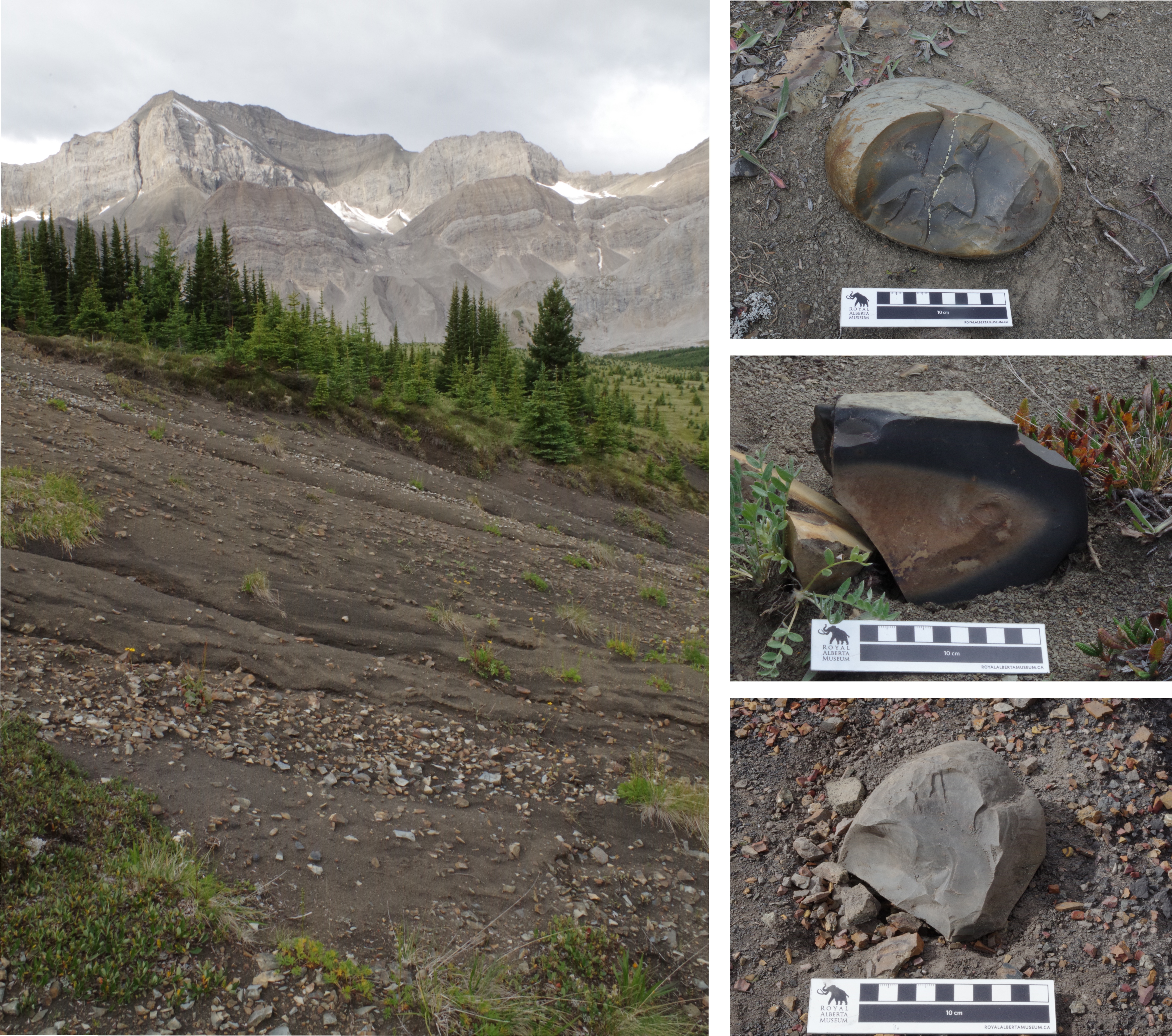
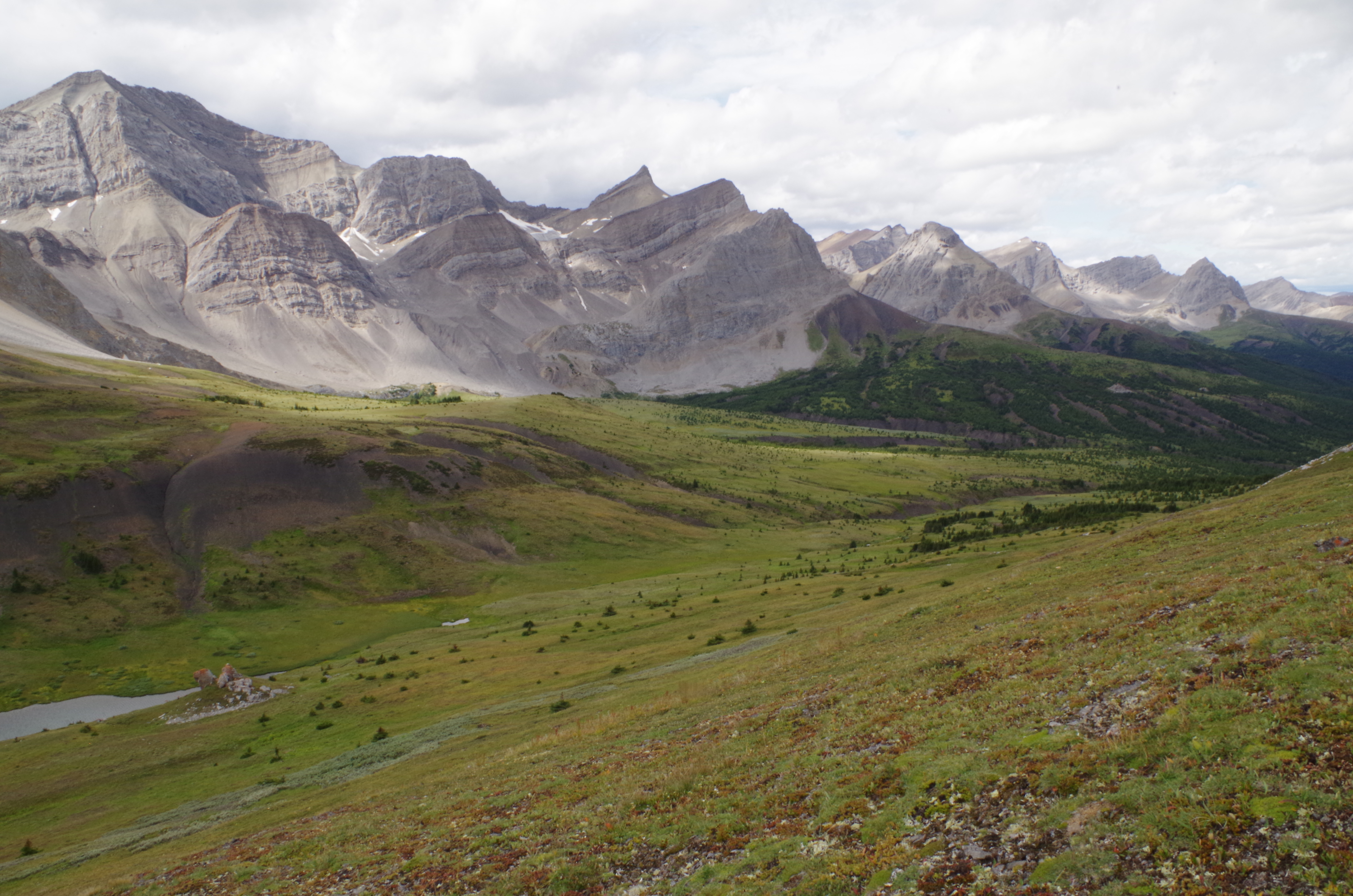
Jasper National Park and Willmore Wilderness Park include some of the most rugged and remote mountains in Alberta; and for over 10,000 years, people have called these places home. A high alpine pass at the north edge of Jasper and south edge of Willmore holds clues of an important resource that ancient people visited year after year, in a place that nowadays only hardy back-packers and horseback visitors can reach.
Glacier Pass contains a quarry of stone that people used to make spear heads, knives, scrapers and other tools. The quarry was discovered by archaeologists B.O.K. Reeves and J. Elliot in the early 1970s. The rocks found there are what geologists call ‘concretions’ that were picked up as rounded cobbles by people long ago. Recent archaeological research tells us that the round rocks were then hammered to get rid of certain pieces and expose the best quality stone for making tools.
Stone cobbles like the ones here at Glacier Pass were picked up and worked into spear heads, knives, scrapers and other pre-contact tools. Source: Todd Kristensen.
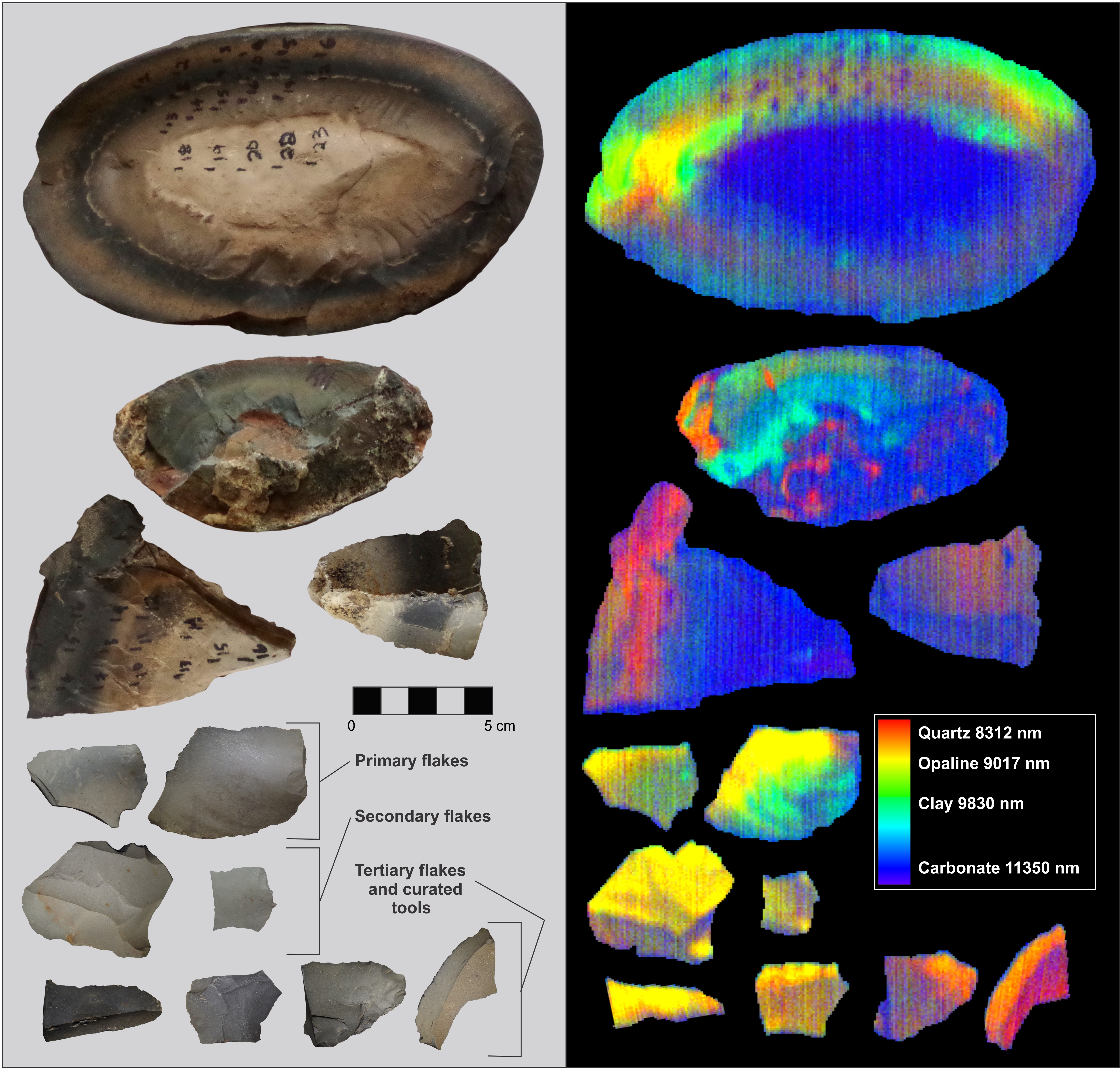
A laboratory technique called hyperspectral scanning has confirmed that the composition of artifacts made from Glacier Pass concretions matches the composition of specific bands or portions of the cobbles from Glacier Pass. Glacier Pass concretions formed when bands of silica-rich rock grew around a core over millions of years. Some bands were good for stone tools while other portions of the rock were thrown out because they were too soft and/or unpredictable to flake or ‘flint knap’. Source: Todd Kristensen.
Based on the number of artifacts found by archaeologists, Glacier Pass was likely visited by small groups of people thousands of times over thousands of years. The stone quarry was part of a seasonal round when people moved from month to month to different areas to exploit or target different things. The alpine concretions at Glacier Pass were probably collected after the snow melted in summer or in fall when people hunted big game animals on high slopes like sheep and caribou.
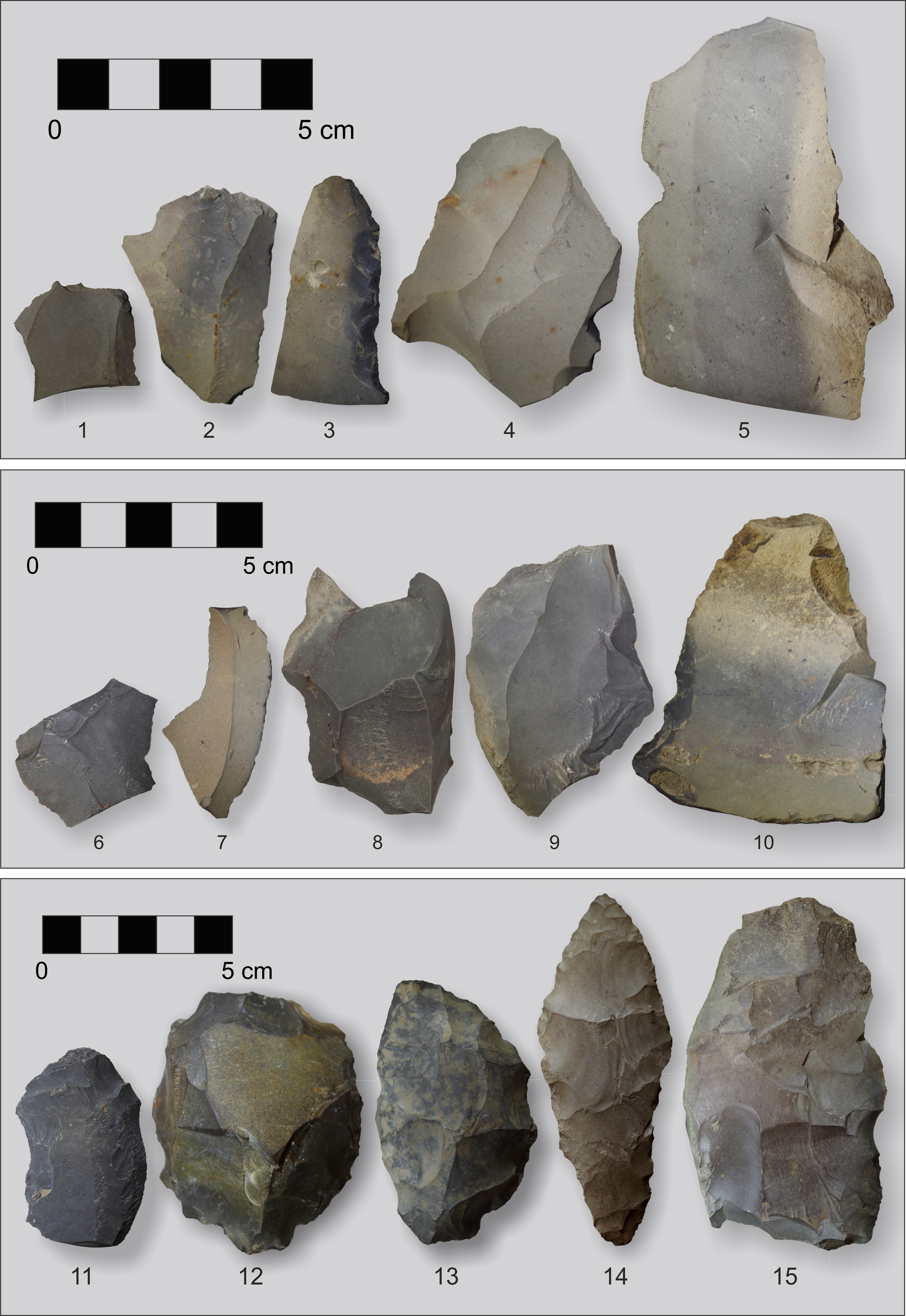
Recent research by an archaeological team from the Archaeological Survey of Alberta, Parks Canada and the University of Alberta has revealed that pre-contact people cracked Glacier Pass concretions to get at specific zones or bands of high quality stone that was ideal for making stone tools. The first two rows in this picture are mostly flakes removed while making tools. The bottom row (artifacts 11-15) are stone tools including knives, a core and a likely spear head that may be over 6,000 years old (14). Source: Todd Kristensen.
Modern visitors to Glacier Pass are unlikely to see tools: most of the artifacts there today are flakes of rock that people broke off while making stone tools. Almost all the finished products were carried away from the area. Visitors are reminded to respect the story of parks and mountain landscapes in Alberta by leaving all artifacts and rocks in place for others to experience. And remember that the land under our feet has a deep history full of geological wonders and human adaptations.
Glacier Pass between Jasper National Park and Willmore Wilderness Park is a beautiful and fragile place. To preserve the story of this landscape, and others in Alberta, visitors are encouraged to leave stones and artifacts in place. Source: Todd Kristensen.
Editor’s note: This is part two of a two-part series on the history of human relationships with trees in Alberta. If you missed part one, read it now.
Written by: Todd Kristensen, Archaeological Survey of Alberta
Development of Alberta’s Forestry Industry
From 1900 to 1910, population growth and steady local demand for lumber meant that most settlements had commercial sawmills. Because of the way that timber berths were leased to operators, most sawmills were small and portable. Some operators harvested in the summer and moved their timber using rivers, flumes (a series of wooden chutes that filled with water and carried logs), splash dams (a temporary wooden dam that held back water that would then be released in a surge to carry logs), and log drives along big rivers that brought wood to riverside mills or to rail yards in river valleys. But winter was generally the ideal time to log because wood could be moved by horses and sleds. Portable sawmills would move machinery on skis to temporary camps in western and northern Alberta. The seasonal nature was perfect for struggling families because farmers could work the fields in warm seasons and cut timber for mills in the winters.
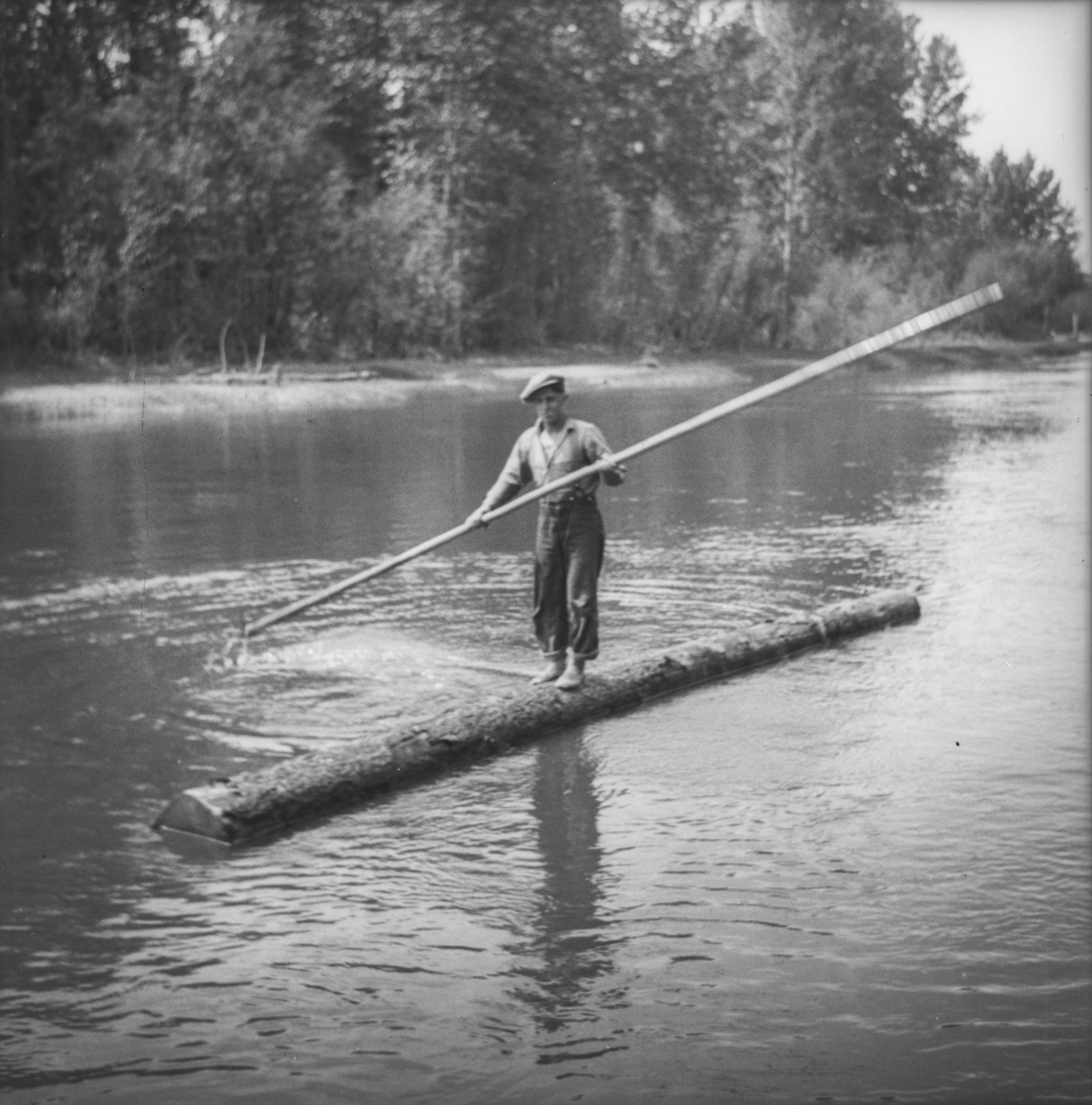
A man poling down Athabasca River between 1937-39 (from the Chisholm Sawmill and Freeman River Lumber Camp). Log drivers floated along with the timbers to dislodge jams and notify the mills when shipments were arriving by water. Image A3790 courtesy of the Provincial Archives of Alberta.
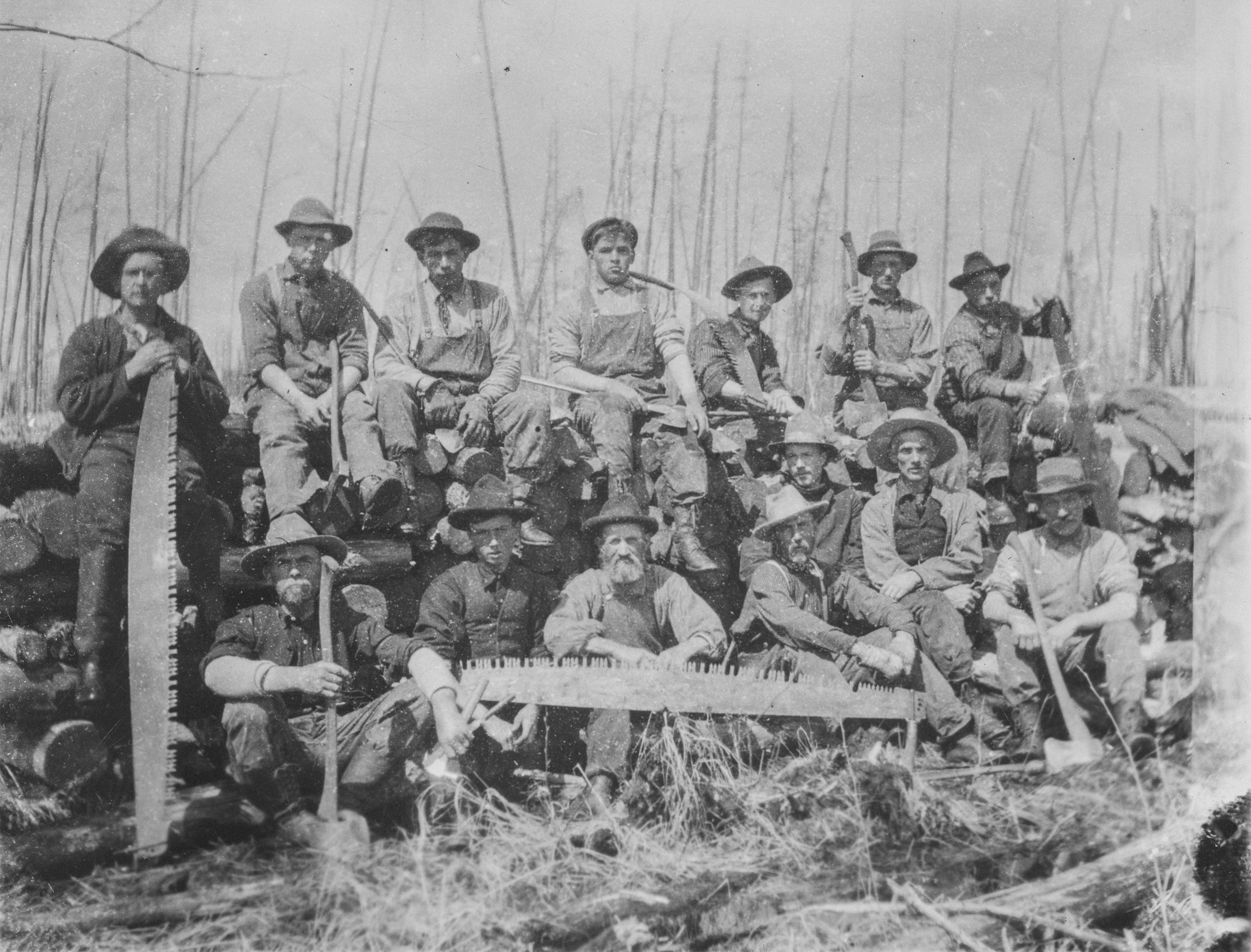
A logging camp (the Jackpine Wood Camp on Little Slave River in 1909) with men and their tools. Image A2532 courtesy of the Provincial Archives of Alberta.
Alberta’s forestry industry was younger than in British Columbia and neighbouring states to the south, many of which had various gold rushes that required commercial sawmills in the 1800s. It was fairly common for Alberta farmers to log in B.C. during winters in the early 1900s and many Alberta ranches provided B.C. logging operations with horses. A good-sized sawmill in B.C. or Alberta could employ several hundred men and up to 60 horses over the winter.