Written by: Todd Kristensen and Emily Moffat, Archaeological Survey of Alberta
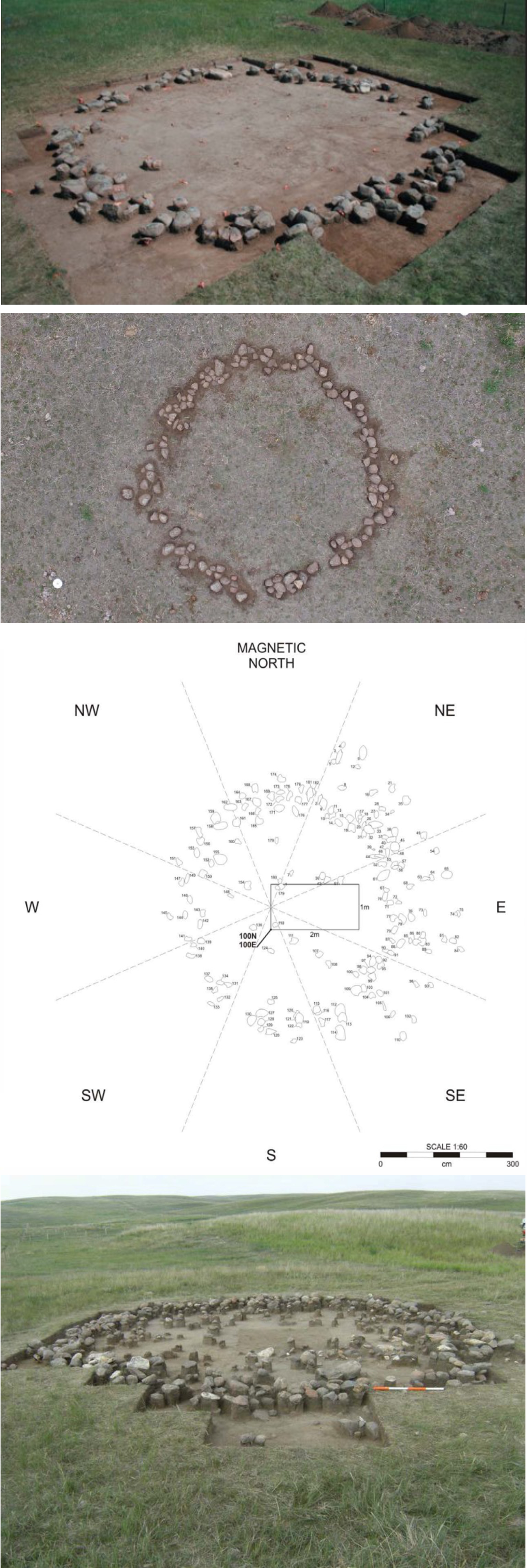
Small rings of rock appear across Alberta’s prairies. These stones once weighed down the bison hide covering of tipis – a type of dwelling used by generations of First Nations. Tipis, and the remnants of them, have drawn the attention of archaeologists and historians in the province for over 70 years. It is estimated that Alberta had a million stone circles before being displaced by farming and other developments. Currently, the province has over 8,000 recorded archaeological sites with tipi rings: some are a single circle (a small camp) while others host over 200 rings in one spot (a large gathering of family and allies). New figures and imagery here highlight decades of archaeological research and help visualize how records of tipi rings can reveal dimensions of pre-contact life.
Exposed, excavated, and mapped tipi rings in Alberta. Source: permits 08-110, 09-050, 11-048, and 21-046.
Part I of The Lure of Gold in Alberta’s History can be read here.
The Last Great Gold Rush
In 1896, gold production in Edmonton reached $55,000,[i] with local banks purchasing gold dust off miners at $15 an ounce.[ii] No small amount for a town of roughly 1200 people. However, this amount was nothing compared to the following year when parties of gold seekers, upon news of rich gold strikes in the Yukon, began outfitting themselves in Edmonton on their way to the Klondike. By the summer of 1898, the stampede was over with local merchants having taken in $500,000.[iii]
When parties slowly began arriving in Edmonton by train in the summer of 1897, the business community quickly seized upon the opportunity and began actively advertising Edmonton as the, ‘All Canadian Route to the Klondike’, ‘The Back Door to the Yukon’, and ‘The Poor Man’s Route to the Yukon.’[iv] By Christmas, there were people from Chicago, eastern Canada, the Atlantic seaboard, Europe, and Australia camped in small groups all over town. Historian J.G. MacGregor wrote that by mid-winter 1898, “…the town was knee deep in Klondikers.”[v]
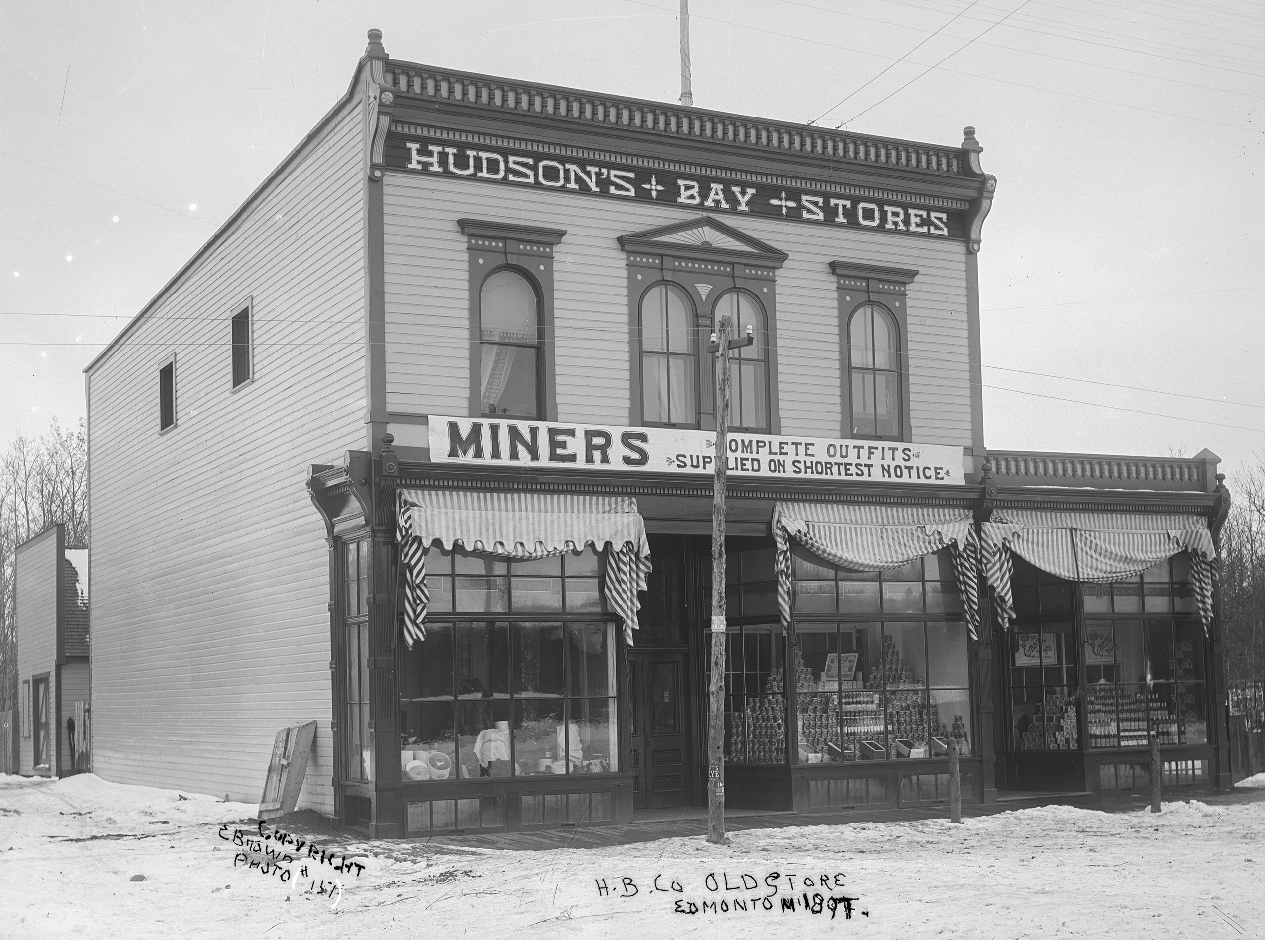
Figure 1. A storefront in Edmonton advertising supplies for prospectors (image B4424 reproduced with permission from the Provincial Archives of Alberta).
On a map, distances could be deceiving, and many lacked the experience required for such a rigorous journey. One man writing to the editor of the Edmonton Bulletin inquired as to the feasibility of travelling to the Yukon by bicycle,[vi] and two Parisians who set off from Athabasca Landing admitted to having originally entertained the idea of travelling to the Klondike by balloon.[vii] The distances alone were daunting but the real challenge was carrying with them two years of supplies. This amounted to 2500 lbs of food and gear for each individual, and, depending on the route and the season, they required horses, dog teams, sleds, sleighs, and boats. Read more →
“Having disposed of our holdings on the creeks the five of us packed through the South Kootenai Pass and soon after started for Edmonton, where we heard they were mining placer gold on the Saskatchewan River. We had no very clear knowledge of where Edmonton was, and there was no one there to tell us.”[i]
– ‘Kootenai’ Brown (1865)
Gold! It was dreams of golden wealth and the promise of adventure that drew thousands of young men west to California and British Columbia in the 1800s. Although never achieving the spectacular wealth in gold of its neighbors to the west, Alberta witnessed its own gold rush in the 1860s, and over the subsequent decades many people passed through the province on their way to other mining frenzies that swept across the northwest. Many prospectors settled in the province and became leading members of Alberta’s burgeoning communities.
The First Gold in Western Canada
The 1849 rush in California brought ‘Forty-Niners’ from the U.S. Eastern Seaboard and Midwest who traveled overland and by sea. Ocean travel also brought Peruvians and Chileans, Mexicans, Australians, Europeans, and Chinese. In the spring of 1858, the easier diggings long since worked out in California, news arrived in San Francisco of discoveries on the Thompson and Fraser Rivers – to the north in British territory.[ii] By July, it was estimated that 30,000 “half-wild Californians” had passed through the sedate, trading outpost of Fort Victoria Read more →
Farming in Alberta has been shaped by a deep and layered history of geological, biological, and human forces. This article takes us back to the beginning.
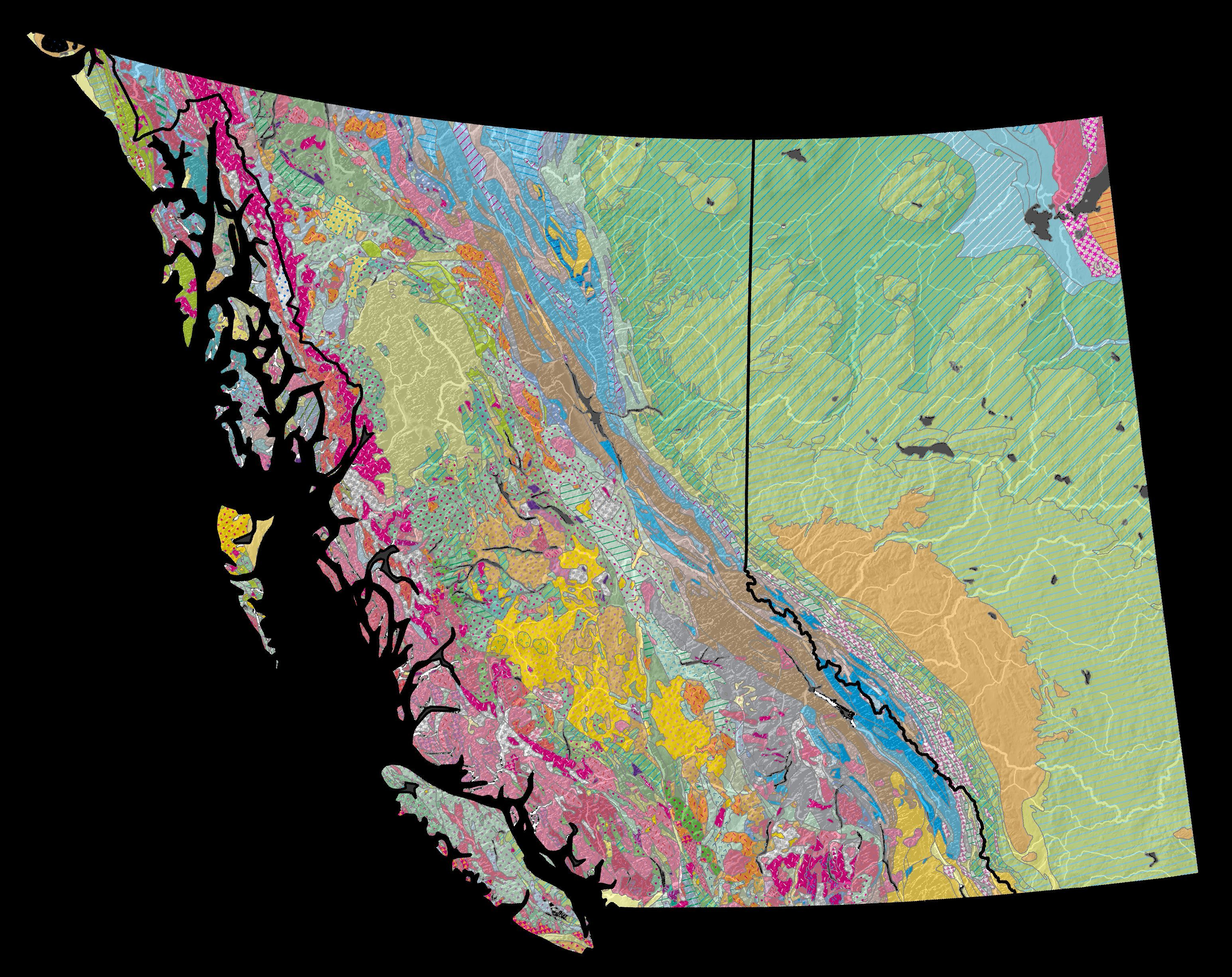
Farming is based on a sliver of soil that caps kilometers of sediment and bedrock. To understand how our fields first formed, we need to read an ancient geological story of how Alberta has been raised and tilted then scoured and capped over time. Alberta has sat inside a continental plate (or ‘craton’) for over 300 million years. Around 180 million years ago, the western edge of this plate began crunching to form the up-and-down terrain of the Coast Mountains of British Columbia (B.C.) and the Rocky Mountains between B.C. and Alberta (Figure 1). Mountain building finished about 50 million years ago.
Figure 1. This is a bedrock map of Alberta and B.C. “Bedrock” refers to the stony basement below our modern soil and loose sediment (gravel, sand, and silt). B.C. is striped with colour because its bedrock is made of diverse chunks of land called terranes that got repeatedly mashed against a moving continental plate that Alberta lay within. One product of this mash-up (‘accretion’) was mountain building (‘orogeny’). Creation of the western mountains forever shaped the development of soils and agriculture in the Prairie Provinces (map by Todd Kristensen with bedrock data from the USGS 2015).
For almost 200 million years, Alberta has been tilted: our bedrock is formed largely of shales and sandstones that built up when sediment either poured off the mountains and solidified into rock or settled down in ancient waters that once filled a basin over Alberta. From about 50 to 5 million years ago, huge sheets of gravel and sand continued to shed off the Rockies (carried by rivers and streams) before settling into our basement. Read more →
For an animal that looks like an awkward collision of snail and squid (Figure 1), ammonites have played surprisingly important roles in international history. To Blackfoot First Nations on the Plains of North America, the ornate edges of ammonite segments resemble miniature bison (sometimes called buffalo), and, for over a thousand years, they have been used in ceremonies to summon bison spirits. Across the ocean, 16th to 19th Century fossil hunters propelled ammonites into palaeontological fame by using them to anchor theories of an ancient earth (Figure 2). In modern Alberta, Canada, miners and members of Blackfoot First Nations are seeking iridescent ammonites to fuel a global demand for art and jewellery; sacred and secular, and now economic, ammonites are immersed in a complex story. Read more →
An Archaeologist’s Perspective on Truth and Heritage
Canada’s Truth and Reconciliation Commission formed to address the residential school experience of First Nations; an Alberta symposium about the commission ended with the question “how can society spread the message of reconciliation”? As an archaeologist, my answer started with a collection of religious medallions found in a garden in northern Alberta and ended with a story about spiritual change, the value of heritage objects, and the powerful roles that historians and archaeologists can play in portraying the past.
Medallions in a Meadow
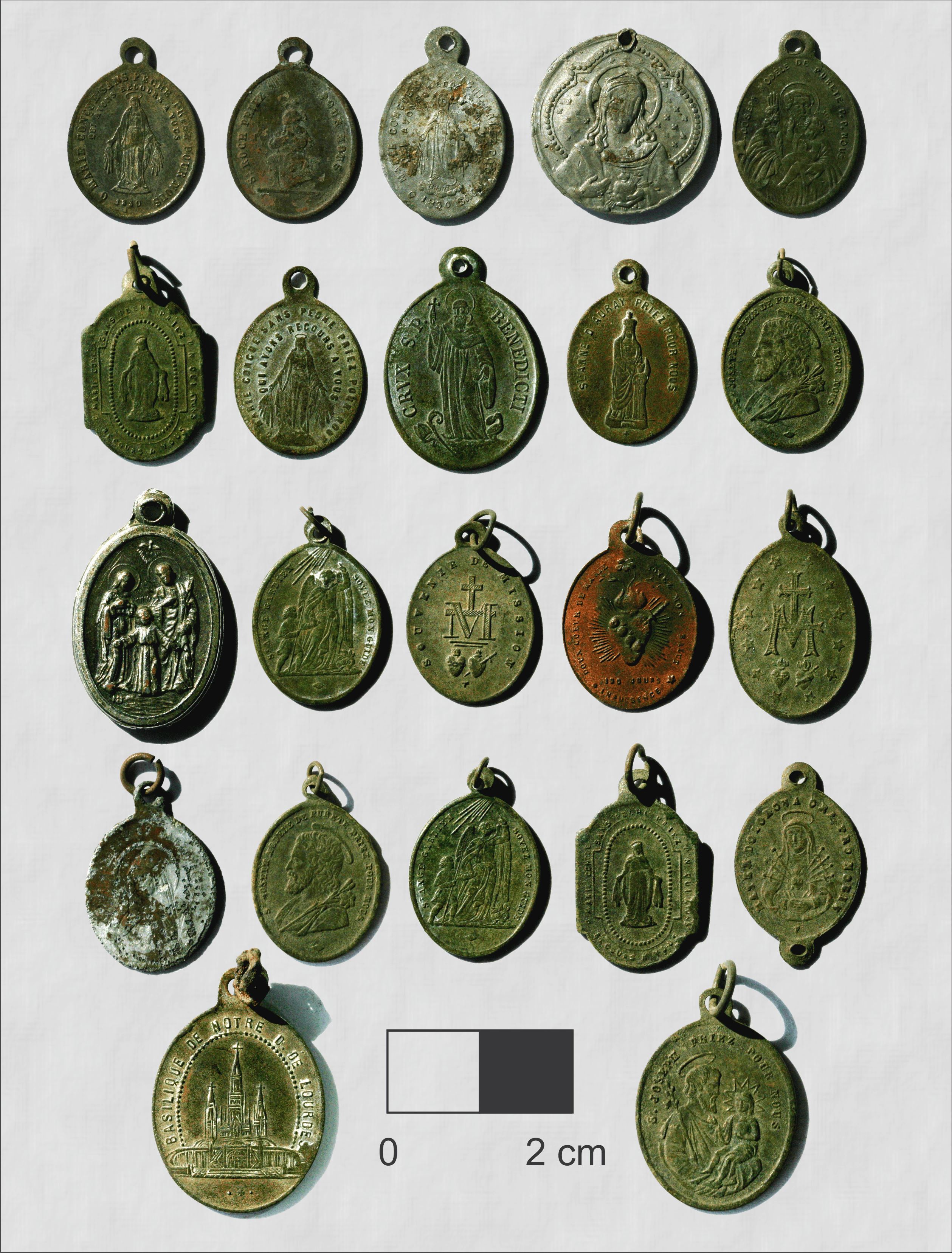
A small, yellow box of Roman Catholic medallions from the 1800s seemed unusual company next to the stone arrowheads in my office. They popped up in a garden next to a First Nations community along Meander River in northwest Alberta. During a site visit, community members shared the collection in the hopes that I could in turn help share the story of the medallions.
Roman Catholic medallions from the 1800s found in northwest Alberta. The medallions are symbols of a time when Christianity was spreading among First Nations communities.
Research revealed that the metal medallions mark an era when Christianity was evolving from a source of curiosity in the early 1800s to a defining cultural element among many Indigenous people in northern Alberta. New spiritual elements replaced others, hybridized with traditional beliefs, or were rejected. Like leaves of the surrounding carrots and parsnips, the garden medallions are a glimpse, or a surface expression, of the important roots of a story, in this case, a tale of syncretism or spiritual blending. By offering an archaeological view of the connection Read more →
Most of Alberta’s Rocky Mountains finished uplifting 50 million years ago – they’ve been pouring sediment across the province ever since. The Rockies shaped our water drainage network and, with the help of glaciers, erected the house of silt, sand, and stone that we all live in. The tilt that our mountains built is largely responsible for the development of our prairie soils and modern agriculture. Our mountains have also shaped how cultures interact and move, which has moulded much of our history.
At first glance, the Rockies are imposing – an impressive barrier rising from the foothills like a stony gate. But for thousands of years, people traveled across and within them to trade and acquire goods. Groups in southeastern British Columbia, like the Kootenai, often descended into Alberta’s valleys to hunt bison and other big game. The Kootenai engaged in trade and formalized sport (like the hoop and arrow game) with local Blackfoot, Cree, and other groups. Large caches of meat and hides were then transported back across Read more →
Pottery traditions have developed independently all over the globe thanks to the versatility of clay as a medium for utilitarian function and the expression of identity. Over 450 sites in Alberta have pre-contact pottery dating from 300 to close to 2000 years old. Fragments or “sherds” of pots at archaeological sites reveal surprising amounts of information about how people lived, how they transmitted knowledge, and why pottery traditions persisted in Indigenous populations for millennia. Ancient pottery production continues to influence modern potters and it can inform how modern society uses material goods to express identity. Read more →
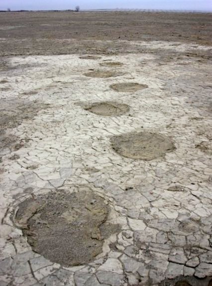
When St. Mary Reservoir in southern Alberta was filled in the 1950s, no one knew that it submerged an incredible record of life from 13,000 years ago. That record, including footprints of mammoth, camel, and horse, was recently exposed – the internationally significant site is now informing opinions about the role humans played in the extinction of Alberta’s ‘megafauna’.
Rare and information-rich trackways from lumbering mammoth were revealed by scouring winds at St. Mary Reservoir (courtesy of Shayne Tolman).
Wally’s Beach
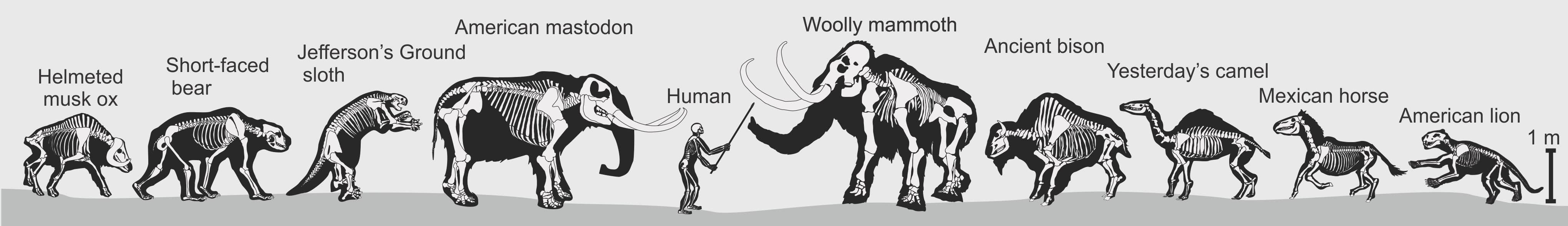
Shayne Tolman, a teacher from Cardston, is responsible for drawing attention to St. Mary Reservoir and Wally’s Beach, a site complex on an ancient island in St. Mary River that is currently being investigated by Dr. Brian Kooyman and a team from the University of Calgary. Archaeologists have discovered that the menu of some of Alberta’s oldest humans included megafauna like camel, horse, and perhaps mammoth. Over six thousand artifacts indicate that people were hunting big game at a time when these animals were likely struggling to cope with climate change. Did human hunting lead to megafauna extinction or are warming temperatures to blame? Many researchers argue that pre-contact human populations were too small to impact big game while others suggest that targeted hunting patterns among small groups could have big consequences.
Megafauna of Alberta at the end of the last Ice Age (produced by Todd Kristensen)
According to Blackfoot tradition, as Old Man traveled north he created the mountains, rivers, grass and trees. When he came to the area of the present day Porcupine Hills in southwest Alberta, he formed images of people from mud and breathed life into them. The people asked Old Man what they would eat, and so, he created images of buffalo from clay and brought them to life. He then took the people to a rocky ledge and called to the buffalo, who ran in a straight line over the cliff: “Those are your food.”
Tens of millions of buffalo once roamed the Great Plains of North America from Alberta’s grasslands down to Texas. To people of the plains, there was no more important food source. A number of ingenious methods were devised for communal (group) hunting – buffalo were lured into ambushes, corralled with fire, chased onto frozen lakes or into deep snow, and driven into elaborate traps called pis’kun by the Blackfoot (translated as ‘deep-blood kettles’). Of the hundreds of mass kill sites, perhaps none is more impressive than the buffalo jump, the most famous of which is Alberta’s Head-Smashed-In. Read more →