Sandstone Conservation in Chinook Country

Written by: Fraser Shaw, Heritage Conservation Advisor

Paskapoo sandstone has been maligned for poor durability, compared to Indiana limestone and sandstones from Ohio or Spain that have been used for conservation projects in Alberta. But to be fair to our homegrown sandstone, masonry in general suffers in Alberta’s climate and in the intense sunlight, drying winds and freeze-thaw cycling in areas like southern Alberta. De-icing salts used for public safety during the long winter months are the nemesis of historic masonry and will relentlessly attack sandstone, limestone and granite alike. How stone is laid in a wall, masonry mortar composition, and design details all contribute to how stone performs over time.

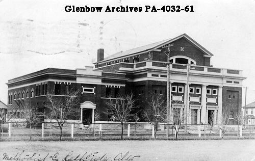
An imposing landmark in downtown Lethbridge, Southminster United Church is a large 1913 building (additions in 1914 and 1950) with a bold Modernist 1961 chapel. The Classical Revival original building dominates with its symmetrical front facade, prominent pediment, monumental engaged columns and exterior of buff-coloured brick with sandstone details. Interestingly, while stone decoration of the 1950 north addition superficially resembles the regional sandstone, it is actually imported Indiana limestone, a different and relatively durable material. Other notable Lethbridge buildings with this combination of local and imported stone are the Galt Museum (former Galt Hospital) and the Bowman Arts Centre (Manual Training School), both Provincial Historic Resources. Lethbridge designated Southminster United Church as a Municipal Historic Resource in 2016.

Circa 1915 photograph from the southwest showing the original 1913 building with its prominent columns and pediment and the 1914 hall addition at left. Source: PA-4032-61, University of Calgary Glenbow Archives Collection.
Read more

Archaeological discoveries and syntheses in Western Canada: the Occasional Paper Series in 2020

Written by: Todd Kristensen, Archaeological Survey of Alberta and Jack W. Brink, Royal Alberta Museum

The Archaeological Survey of Alberta is proud to kick-off Occasional Paper Series No. 40 with its first two articles, which are available for free download here:

The atlatl weights of Saskatchewan

The rock art of the Williams Coulee site, EcPl-16, southwestern Alberta

Individual articles are published online throughout the year and the final compiled volume is typically released in spring. We encourage submissions from archaeologists in cultural resource management (CRM), universities and other heritage professions.

Archaeologists used a computer software program (Dstretch) to enhance the images of painted figures in southern Alberta (image by Jack Brink).

Occasional Paper Series No.40, “Archaeological discoveries and syntheses in Western Canada, 2020” features articles with a broad range of topics about archaeology on the Northern Plains and Boreal Forest. The first paper summarizes an interesting stone tool called an atlatl weight that hunters on the plains used for several thousand years. The second paper documents an impressive archive of rock art found in a small coulee rock shelter in southern Alberta. Both articles relied in large part on discoveries reported and shared by farmers and ranchers. Look for four more articles to be released in the next two months to complete the volume.

We hope the volume informs future work and research in Alberta. Interested authors can pitch a paper or idea to the editorial committee. Past volumes are available for free download here:

Back on the Horse: Recent Developments in Archaeological and Palaeontological Research in Alberta, Occasional Paper No. 36 (2016)

After the Flood: Investigations of Impacts to Archaeological Resources from the 2013 Flood in Southern Alberta, Occasional Paper No. 37 (2017)

The Swing of Things: Contributions to Archaeological Research in Alberta Occasional Paper No. 38 (2018)

Advancing Archaeology: Industry and Practice in Alberta, Occasional Paper Series No. 39 (2019)

Spring 2021 Listing of Historic Resources

Written by: Colleen Haukaas, Archaeological Survey

In April the Historic Resources Management Branch (HRMB) released the Spring 2021 Edition of the Listing of Historic Resources. The Listing is a biannual release of lands in Alberta that are known to contain or are likely to contain lands of a sensitive historic nature. Land parcels used in the Listing are Legal Subdivisions in the Alberta Township Survey system. The Listing is generated as a tool to aid developers, land agents, planners and other stakeholders when planning land-based development projects in Alberta.

Each land parcel in the Listing is assigned a Historic Resource Value (HRV) ranging from 1 to 5:

Historic Resource Value (HRV)Description
HRV 1contains a World Heritage site or a site designated under the Historical Resources Act as a Provincial Historic Resource
HRV 2deactivated (formerly used to designate a Registered Historic Resource)1
HRV 3contains a significant historic resource that will likely require avoidance
HRV 4contains a historic resource that may require avoidance
HRV 5high potential to contain a historic resource
1See more information in Listing of Historic Resources: instructions for use

Each entry is also assigned a category of the primary historic resource category of concern:

CategoryDescription
aarchaeological
ccultural
glgeological
hhistoric period
nnatural
ppalaeontological
Sample map of the Listing of Historic Resources at Edmonton. Map was generated with the online Listing webmap.

A legal subdivision can have more than one HRV rating or category. For example, a legal subdivision that contains both an archaeological site and an area of high palaeontological potential may be classified as 4a, 5p.


The Listing is generated by gathering information from consultants and researchers working in archaeology, palaeontology, history and other industries in Alberta, and comparing their findings with known resources at the HRMB. Our staff use Geographic Information Science software to compile and generate the Listing.

To view the new version of the Listing, see the online webmap version here. For more details or for information for developers, see our website.

Reciprocity and Renewal: The Blackfoot Seasonal Round

Written by: Blair First Rider and Laura Golebiowski, Aboriginal Consultation Advisers

Oki! For many of us, the spring season represents new life and a fresh start. But did you know, in Blackfoot culture, the new year begins in the spring? Aboriginal Consultation Advisers Blair First Rider and Laura Golebiowski, both based in Treaty 7, discuss the significance of the seasonal round: a concept that not only structures the year, but also our relationships to the land and one another.

We meet today on Kainai Nation at an area called Weasel Fat Bottom, a flood plain on the south side of the Oldman River. These flats also served as an ideal traditional camping location, with proximity to water, cottonwood tree stands and grazing areas. The trees provide shelter from the wind, and beneath them medicinal plants and berries grow. We are here to learn about the seasonal round: a concept that has guided the travel, occupation and relationships of the Niitsitapi (how the Blackfoot refer to themselves, translating to “the real people”) since time immemorial, and one that still has important teachings today.

Blair First Rider stands in front of a modern medicine wheel, built during a recent Blackfoot Confederacy gathering. Source: Laura Golebiowski.

In the old days, Sky Being Ksisstsi’ko’m (Thunder) gave the Niitsitapi the Thunder Medicine Pipe Bundle. The pipe offered protection, as well as a promise that Ksisstsi’ko’m would bring the rains that would make the berries grow large and ripe. Accordingly, the new year is marked by the first clap of thunder of the first rainstorm. It is commemorated with ceremony: the gathering of the seven Societies and the opening of the sacred bundles. Through prayer, song and dance, the relationships and commitments between Niitsitapi and the Creator, the Sky Beings and the land, are renewed and affirmed. As Betty Bastien wrote in Blackfoot Ways of Knowing: the Worldview of the Siksikaitsitapi, “During these ceremonies we acknowledge and give thanks to our alliances for another cycle. We ask for continued protection, prosperity, long life, growth, and strength.”

Read more

Recognizing Women with Canadian Place Names

Written by: Ron Kelland, Geographical Names Program Coordinator

At an online event on March 8, 2020, Seamus O’Regan, the Minister of Natural Resources Canada launched Recognizing Women with Canadian Place Names: Women on the Canadian Landscape. This interactive, digital map was developed by the Geographical names Board of Canada to highlight approximately 500 places and geographical features in Canada that are named for women.

Screenshot of the “Recognizing Women with Canadian Place Names” Interactive map. Source: Natural Resources Canada.

March 8 was International Women’s Day; a day acknowledged around the world to raise awareness of issues facing women, such as gender equity, and to celebrate the social, cultural and political achievements that have been made by women to their communities, regions and nations. The map was launched on that day as part of those annual celebrations.

Through history, the recognition of women has tended to be forgotten. For generations, women have been largely voiceless in history; overlooked by default and design. The essential domestic role of settler women has not been discussed to the same extent as the work of their husbands, fathers and brothers breaking the land, even though these women toiled and suffered just as men had. Even women who were admitted to the professional, scientific or professional world have often seen their accomplishments ignored or downplayed in favour of those of their male colleagues. The same trends are found in the world of cartography and place naming.

Read more

Fingerprints in Glass: Obsidian and Ancient Human Relationships

Written by: Todd Kristensen, Archaeological Survey of Alberta

A butchered bison leaves bones behind; a fur trade post leaves rotting walls for archaeologists to discover. But humans are more than what we eat and build. To many, our lives are defined by relationships to other people. How do archaeologists in Alberta uncover and reconstruct human relations from 10,000 years ago when not much preserves in the soil?

Archaeologists use microscopic clues to link stone artifacts back to the quarries where the rock originated; this “provenance” work can reveal ancient networks. In a blend of geochemistry and sociology, researchers use volcanic rocks in particular to understand how groups interacted and moved across landscapes for millennia.

Obsidian arrowhead found in the Grande Prairie area of northwest Alberta. Source: Todd Kristensen.
Read more

Canada Post commemorates an Alberta community for Black History Month

Written by: Ron Kelland, MA, MLIS, Geographical Names Program Coordinator

February is Black History Month, a time dedicated for the commemoration of the history, heritage and legacy of the Black community in Canada. Since 2009, Canada Post has produced a series of commemorative postage stamps recognizing aspects of Canada’s Black community. These stamps have featured individuals and communities as well as military contributions and sporting accomplishments. In 2012, John Ware, southern Alberta’s famous Black cowboy and rancher was featured.

These stamps – the 13th issue in Canada Post’ Black History Month series – tell the stories of two Black communities nearly one hundred years and thousands of kilometres apart. Both rose from hardship to survive and grow for a time and served as stepping stones for the success of future generations of Black Canadians. Source: Canada Post.

This year, Canada Post turned the spotlight once again to Alberta, this time producing a stamp recognizing the community of Amber Valley.  

Read more

Recent Municipal Historic Resource Designations

Written by: Ron Kelland, MA, MLIS, Geographical Names Program Coordinator

Under the Historical Resources Act, Alberta’s municipalities have the authority to designate sites and buildings as Municipal Historic Resources. This designation authority gives municipalities the ability to ensure that the preservation of their community’s history and heritage. Municipal Historic Resources are eligible for listing on the Alberta Register of Historic Places, although there is no requirement for municipally designated resources to be listed on the Register. However, designated resources must be listed on the Register to qualify for Culture, Multiculturalism and Status of Women’s conservation grants. To be listed on the Register, a Municipal Historic Resource must certain documentation prepared that explain the heritage value of the resource and guide the management of the property.

Historic Resources Management of Culture, Multiculturalism and Status of Women works with Alberta’s municipalities to list their Municipal Historic Resource Designations. A number of properties designated in previous years by a municipalities across the province have recently been added to the Alberta Register of Historic Places.

Read more

Newbrook Observatory: Photographing world history in Thorhild County

Written by: Matthew Wangler, Executive Director, Historic Resources Management Branch

Alberta has a rich and fascinating history, and occasionally events in our past resonate with happenings of global consequence. That was the case in 1957, when a dedicated scientist working in a meteorite observation station in Newbrook captured the first North American image of Sputnik 1 – an object which came to embody both the fears and aspirations of a generation, and which heralded the beginning of a new age in science and geopolitics.

Sputnik I. Source: Wikipedia Commons.

The roots of the Newbrook Observatory can be traced to 1946, when the United States and Canada agreed to work co-operatively on space science projects, particularly meteorite observations. The northerly situation of Newbrook – with its clear view of the night sky and its relative lack of auroral interference – made it an ideal location for establishing an observation station to assist in this joint effort. Constructed in 1951, the Newbrook observatory opened in 1952 as a field station of the Stellar Physics Division of Canada’s Dominion Observatory in Ottawa.

Read more

Geographic Information Science and the Listing of Historic Resources

Written by: Colleen Haukaas, Archaeological Survey

Join the Historic Resources Management Branch as we celebrate GIS Day 2020. GIS, or geographic information science, is a scientific framework for gathering, analyzing and visualizing geographic data to help us make better decisions. At the Historic Resources Management Branch, we have been using GIS since the early 2000s to better understand our historic resources.

GIS at the Historic Resources Management Branch

Alberta is home to tens of thousands of historic resources, and our Branch needs to be able to analyze where those resources are, if there are concerns about the resources, and the best way to address those concerns. At the Branch, we maintain several geospatial databases for our program areas: archaeology, palaeontology, Aboriginal heritage and historic structures. Each database is modified throughout the year as new information is made available (e.g. when new sites are recorded).

We investigate archaeological sites individually in research, but we also need to understand how sites relate to each other and to broader cultural and natural landscapes. GIS helps archaeologists understand these broader questions. The images below show how we use GIS to understand the broader context of archaeological sites Head-Smashed-In Buffalo Jump and Calderwood Buffalo Jump, courtesy of Todd Kristensen. Archaeologists have investigated the sites through methods such as survey, excavation and artifact analysis. Through GIS, we can then begin to understand the context of the sites within their local topography and see the gathering area, drive lanes and kill areas. We can also see how the sites fit into the broader tradition of bison jumps, pounds, and kill sites on the Great Plains.

Read more