Editor’s note: The Last Baron debuts on CBC Gem on Sept. 17. It will be shown on CBC-TV in Alberta and B.C. at 7 p.m. on Sept. 18. If you want to support the filmmakers, they are currently crowdfunding to help finance a feature-length version of The Last Baron.Photos in this story courtesy of Amber Bracken/Back Road Productions, unless otherwise noted.
Written by: Jared Majeski, Historic Resources Management Branch
Spend enough time driving down the highways and range roads in Alberta, chances are you’ll pass an old grain elevator. Hulking wooden structures stretching to the sky, weathered by decades of neglect. These prairie cathedrals are a ubiquitous tribute to how things used to work, before the inevitable march of technology pushed them aside. Drive down those same roads, through the villages and towns dotting Alberta, and you’ll find another symbol of how things used to work. This time, in the form of a structure you or I may take for granted: the humble diner. Specifically, the once-omnipresent eatery of so many small Alberta towns. Before Alberta had McDonald’s, it had the Burger Baron.
Premiering this Friday on CBC Gem is The Last Baron, a uniquely Albertan documentary about the history of the Burger Baron. Written, directed and co-produced by local writer and filmmaker Omar Mouallem, The Last Baron tells the story of how a community of Lebanese immigrants, through ownership of Burger Baron franchises across Alberta, supported their families, friends and communities by slinging fries, burgers and shakes to hungry Albertans. The film touches on the murky history of the original Burger Baron intellectual property, relationships between franchisees and the future of the Burger Baron business model.
Mouallem is also in an ideal position to tell this story: his family opened a Burger Baron restaurant in High Prairie in 1987. He remembers: “Originally, my dad planned on calling it Prairie Pizza. It wasn’t the plan to call it a Burger Baron. It was a last minute idea suggested to my Dad by his uncle in Slave Lake, who also owned a burger Baron. He said, ‘Look, you’re on Main Street. You’re on a main highway, and the main street of town. Burger Baron is a good name. It has done great things for us. You should just go ahead and use it to.’ And he did.”
Written by: Jared Majeski, Historic Resources Management Branch
One thing that never gets old living in the Prairies is the sky: big, expansive, endless. Exactly the kind of place (and space) for aircraft of all shapes and sizes to explore. We can learn about a specific kind of aircraft, the alien type, from a digitized production from ACCESS TV below.
Unidentified Flying Objects, or UFOs as the kids like to say, have been part of lore and science fiction for centuries. There are thousands of sightings around the world, but solid proof or admission has continued to elude us. Produced sometime in the early 80s, this short documentary combines first-hand accounts from local Albertans with scientific explanation — all set to surprisingly evocative synthesizer soundscapes. You’ll also learn about Project Magnet, a program developed by Transport Canada to study UFOs in the 1950s.
So, put down those episodes of X-Files and learn about potential alien life right in your own backyard. And while you’re at it, go explore the rest of the film and video on the Provincial Archives of Alberta Youtube channel.
Written by: By Dr. Todd Kristensen, Archaeological Survey of Alberta
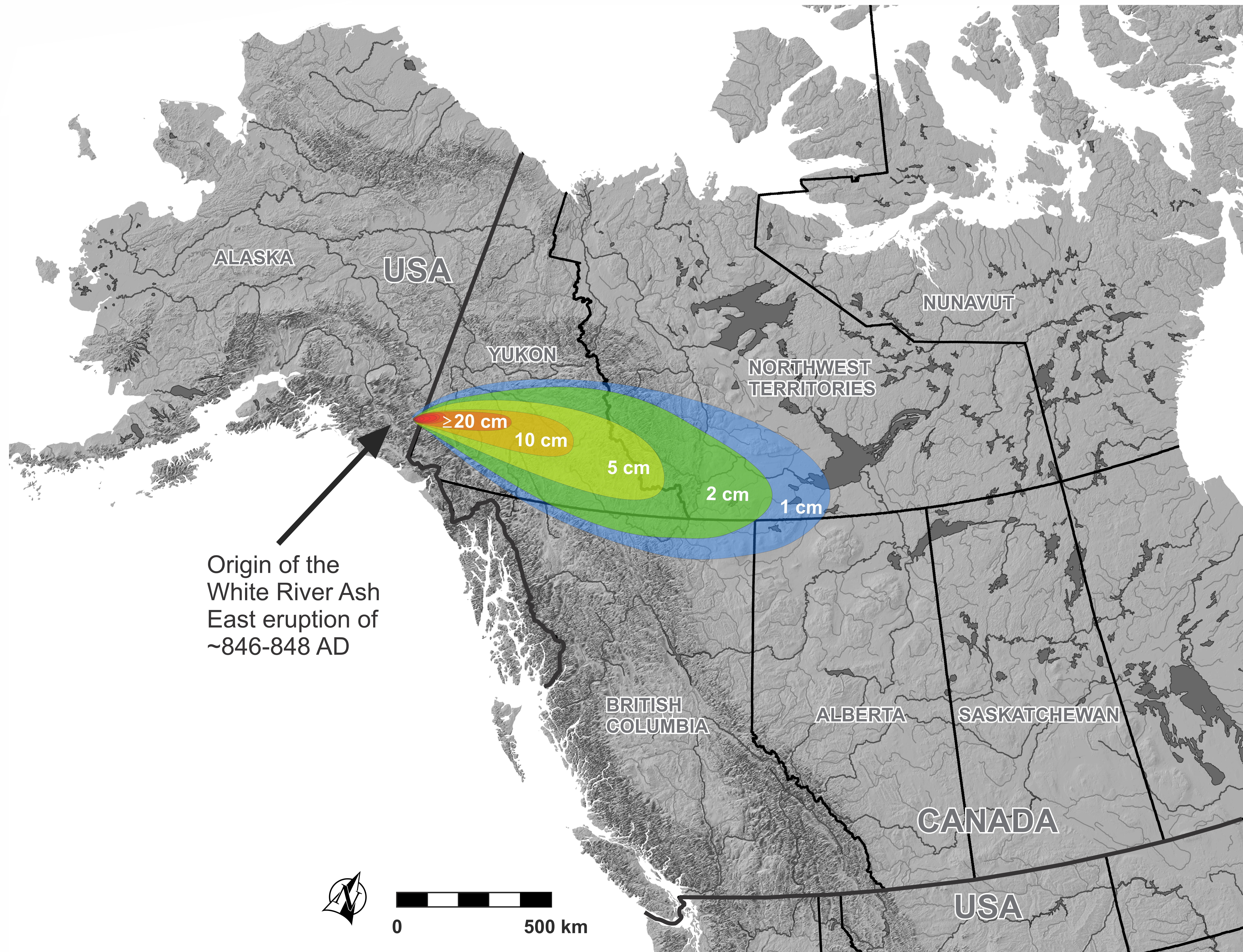
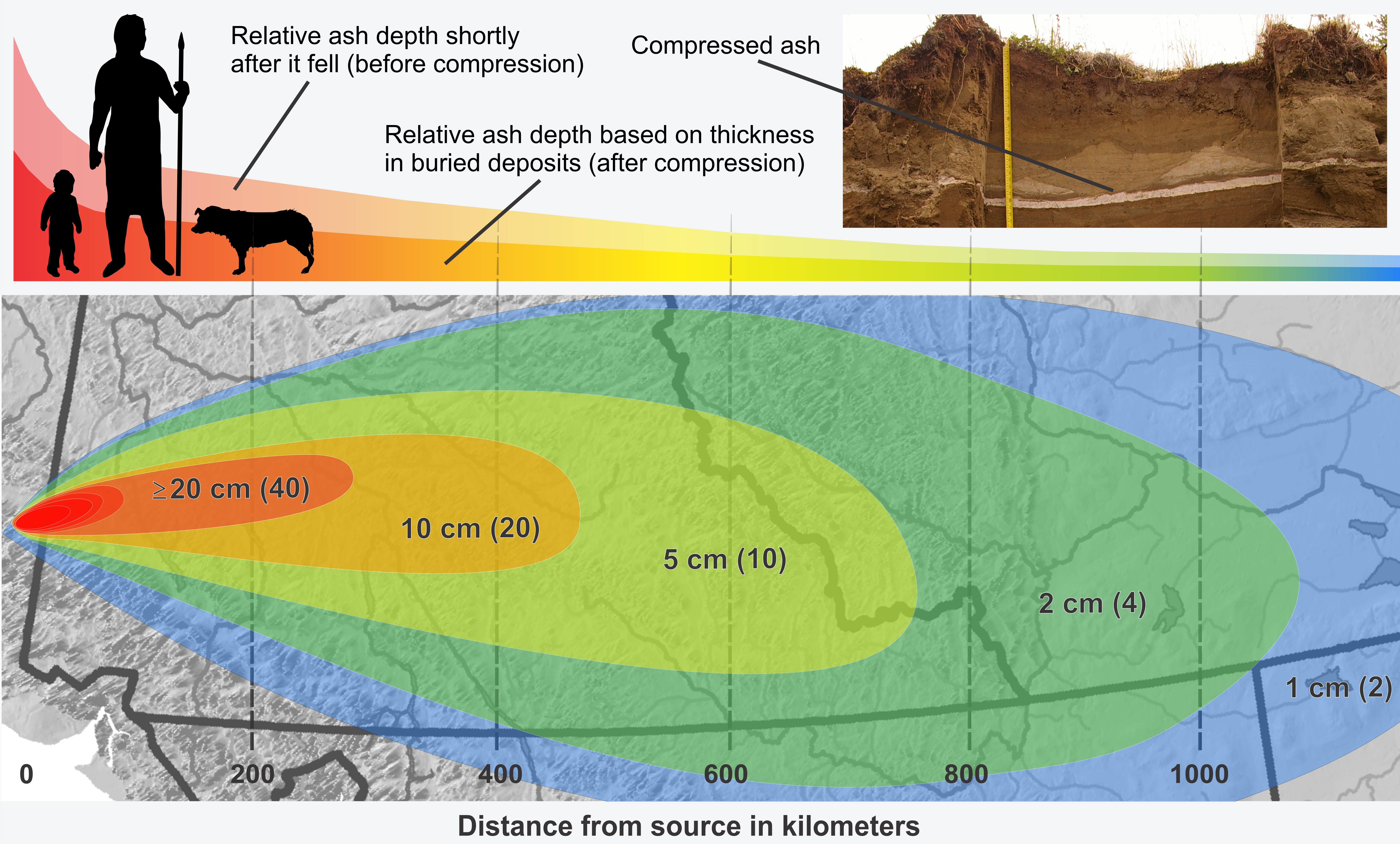
Archaeologists compare records before and after ancient volcanic eruptions to understand how the lives of people changed. Impacts of ecological disasters on humans can be detected along local and broad scales: how did Indigenous people cope at a specific site and how did human relationships change across vast regions? A massive eruption 1,200 years ago, called White River Ash East, changed the way that people in northern Canada hunted and gathered in areas affected by volcanic ash, which fell in beds up to 1 m thick. Beyond the ash footprint, human networks were forever altered, with ripple effects that spread through Alberta and North America.
A volcano in Alaska sent ash east across southern Yukon, southwest NWT, and into northwest Alberta. Geologists study beds of ash (tephra) to reconstruct the size of eruptions. The shaded colours are rough estimates of how thick the volcanic ash is.Source: Todd Kristensen.
Ash depth relative to people (top). When the ash originally fell, it was loose and deep but would’ve compressed over time (top right inset). Based on other eruptions, the White River Ash East tephra may have shrunk up to 50% in the following decades after it fell. At bottom is an estimate of ash thickness in current sediments with the original ash thickness in brackets.Source: Todd Kristensen.
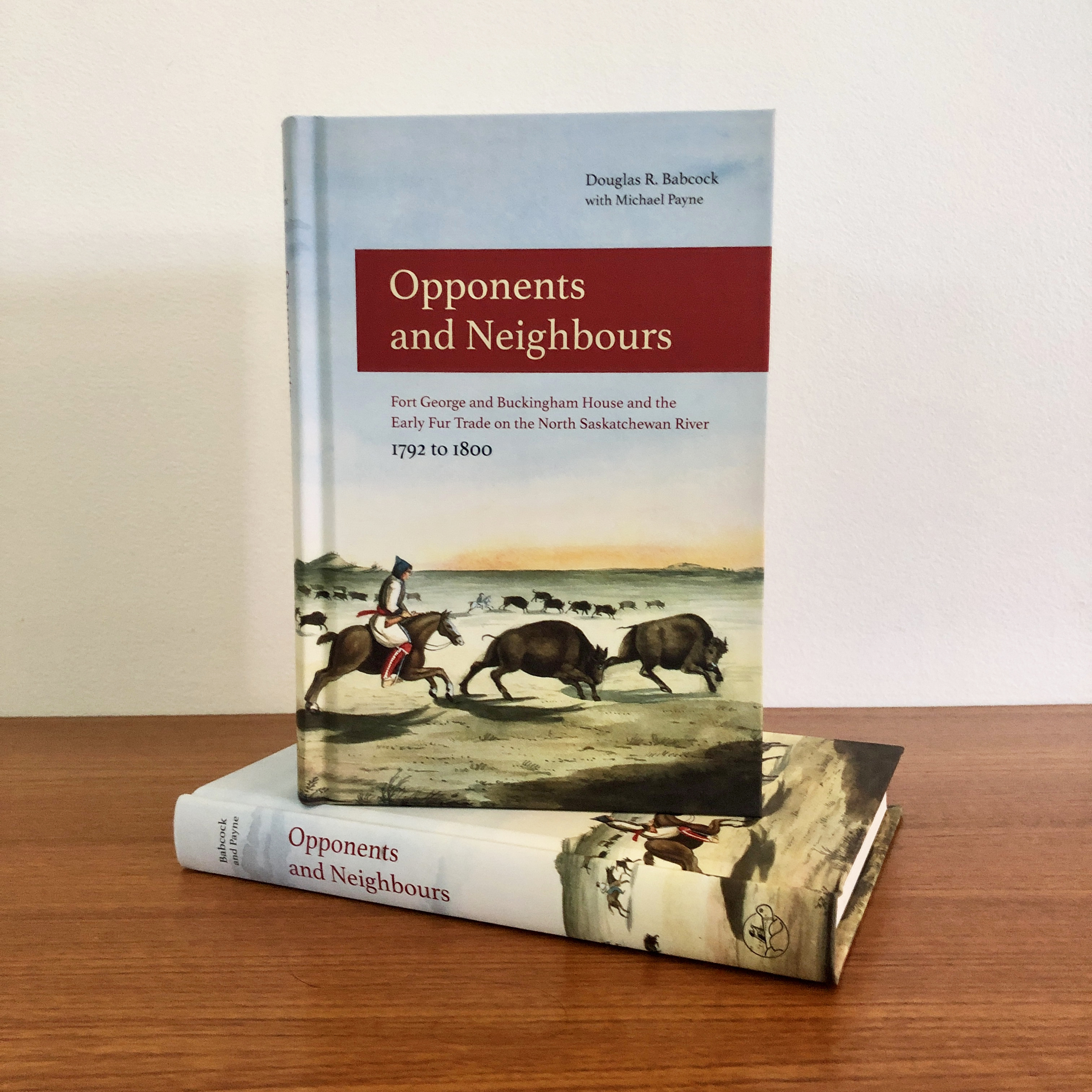
Editor’s note: After years of research and writing and working in conjunction with the Friends of the Forts Society, it is with great pleasure and pride that we announce the publication of Opponents and Neighbours: Fort George and Buckingham House and the Early Fur Trade on the North Saskatchewan River 1792 to 1800.Below you can read about the journey it took to publish the book, as well as some excerpts from the publication. Opponents and Neighbours isavailable for purchase through the Provincial Archives of Alberta store.Proceeds from book sales go to the Friends of the Forts Society whose mission is to support and enhance the Fort George & Buckingham House Provincial Historic Site.
Written by: Suzanna Wagner, Program Coordinator, Fort George and Buckingham House and Victoria Settlement
BETWEEN 1792 AND 1800, the North West Company’s Fort George and the Hudson’s Bay Company’s Buckingham House operated on the North Saskatchewan River, attracting trade from the parklands in which they were located, the grasslands to the south, and the woodlands to the north. Indigenous nations interacted with a varied group of traders. The trade was conducted with respect and offered reciprocal benefits to all parties as befits transactions between friends, allies and eventual kinship groups. Trade protocols involved ceremonies, speeches, ritual gift exchanges, sharing of the calumet peace pipe and mutual professions of friendship and brotherhood. The posts were more than venues of commerce; they were a common meeting ground for people of diverse cultures. There were numerous country marriages or marriages a la façon du pays between company men and Indigenous women. Many children were conceived, born and raised into adulthood by stable, supportive and nurturing families. Children, whose mothers were of this continent and whose fathers travelled half the world would themselves have offspring whose descendants inhabit the land till the present time.
Opponents and Neighbours had its start as part of the research done to support the building of the Fort George & Buckingham House Provincial Historic Site in 1992. This large research project was undertaken by Douglas Babcock, a historian with the Government of Alberta’s Heritage Division. The manuscript was eagerly devoured by interpreters at the historic site for many years.
Several years after the initial manuscript was written, another historian with the Heritage Division, Michael Payne, reviewed the manuscript. He took all the fur trade research and history that had been published after Babcock’s manuscript was written and used it to better understand his research. Payne updated the manuscript to reflect the latest historical writing and research.
And in the last few years, a third Alberta Heritage historian, Peter Melnycky, also reviewed the manuscript and updated it based on yet more newly published historical research and scholarship.
With support from the Friends of the Forts Society and graphic design work from Alberta Heritage graphic designer Denise Ahlefeldt, publication is now complete.
This book, much like the fur trade it discusses, took many years and a great many people to successfully bring it up the long road to publication: writers, researchers, historians of the fur trade who work with Alberta Heritage and those who don’t, archivists, distribution and marketing people, a graphic designer, and of course, our funders. Thank you so much to everyone who directly or indirectly, made this book possible.
We hope you enjoy a few excerpts from Opponents and Neighbours:
Editor’s note: Alberta announced that museums and historic sites can reopen as part of Stage 2 of Alberta’s Open for Summer Plan. However, for some seasonal and smaller sites, given how short the season would be as well as the close quarters at some of these sites, the decision was made for Victoria Settlement Provincial Historic Site to stay closed for 2021. Go to Victoria Settlement social media for online content, along with details about reopening in 2022.All photos below taken by Bri Vos unless otherwise indicated.Banner image courtesy of the Victoria Home Guard Historical Association.
Written by: Suzanna Wagner, Program Coordinator for Victoria Settlement and Fort George and Buckingham House and Krista Leddy, Métis Crossing Experience Development Coordinator
Métis Crossing is a gathering place for all people to learn about Métis culture and people. Sitting along the historic Victoria Trail and the North Saskatchewan River, the stories of the Métis families who thrived here are shared through original river lot homes and buildings, recreations of seasonal harvesting camps, and Métis interpreters inviting visitors to experience elements of culture through arts, skills, cuisine, and stories.
Victoria settlement 1862-1922. Source: Leslie Hurt, Occasional Paper Series No. 7.
Victoria National Historic District is 15 minutes south of Smoky Lake (or 1.5 hours northeast of Edmonton) along the North Saskatchewan River. The river lot communities that once stretched along the banks of rivers were common in Alberta. The long narrow land divisions gave the community a different feel than today’s towns and villages, with their overlapping criss cross of streets.
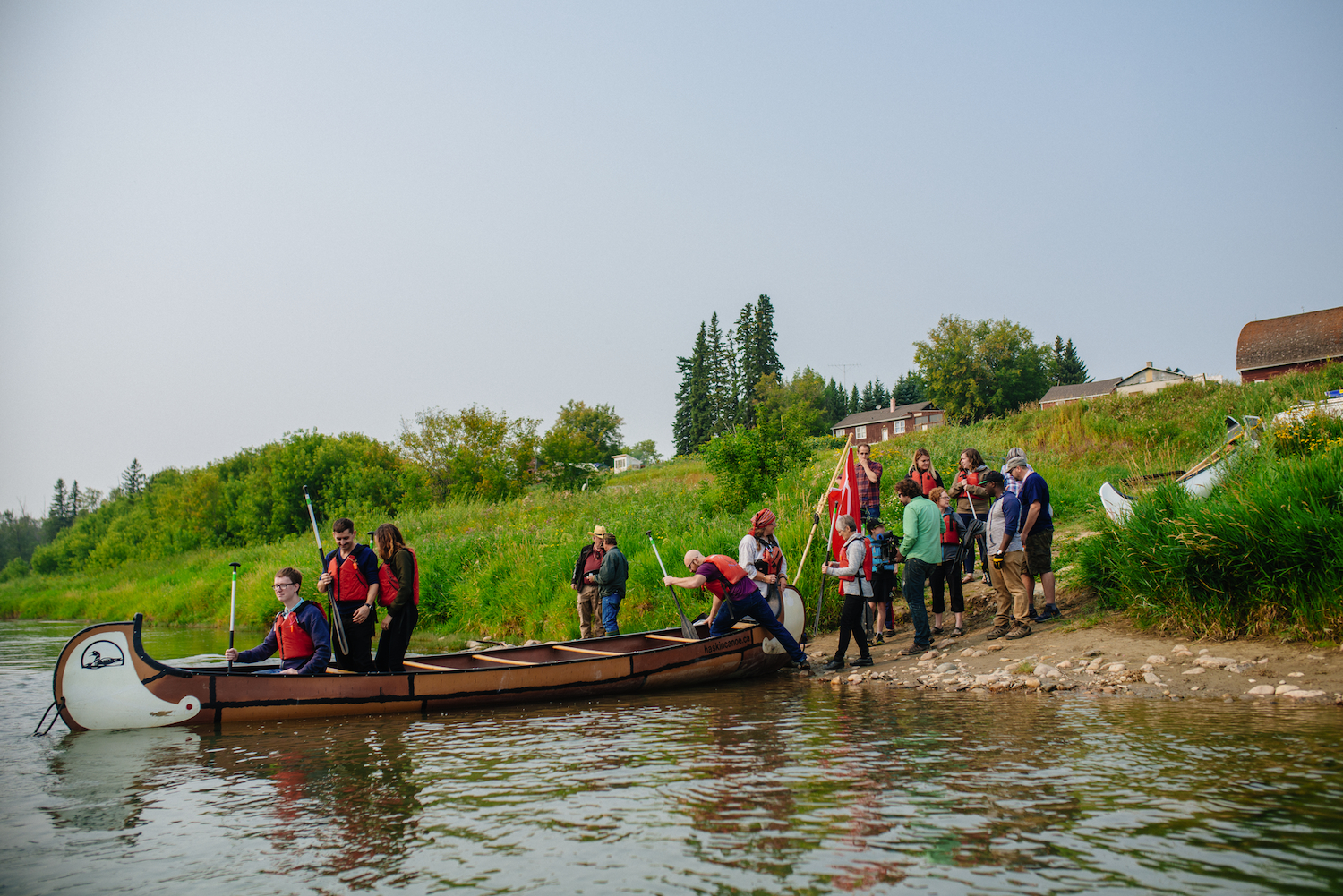
In 2017, Victoria Settlement Provincial Historic Site (river lot 6) and Métis Crossing (river lots 10-14), piloted Paddle Into the Past, an immersive 3 hour fur-trade program which invites visitors to explore the history and culture of the river lot community and the river which connects them. What better way to experience one of Alberta’s most prominent river lot communities than through a collaboration between two river lot neighbours?
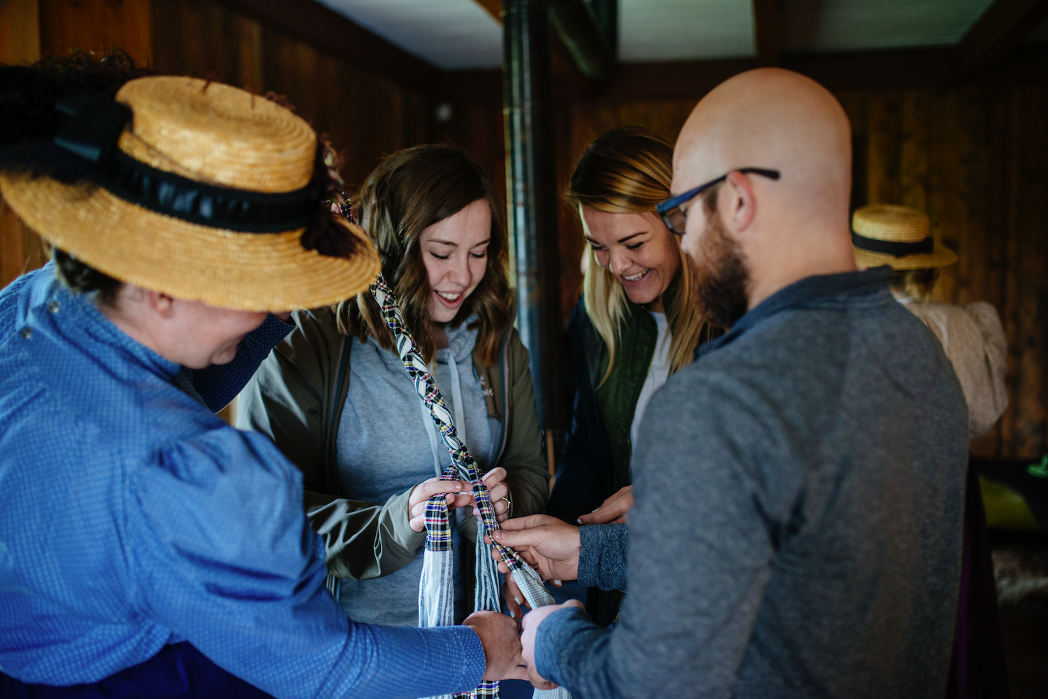
Métis Crossing is a cultural gathering centre run by the Métis Nation of Alberta. Here visitors are invited to experience elements of Métis culture, including finger weaving techniques and stories about buffalo hunts. The many Métis residents of Victoria Settlement river lot community often went south for the buffalo hunt. Buffalo hunts were communal affairs, but also very dangerous.
When was the last time you travelled to the neighbours’ place by paddling down the river? Once you’ve explored Métis Crossing, you’ll get to travel to Victoria Settlement… by canoe!
Once you step off the canoe at Victoria Settlement, you’ll find yourself back in 1896: one of the last years of the fur trade at Fort Victoria. You can explore the fort through ground markings which outline where each building was, and see what the home of the man in charge of the post (“The Clerk’s Quarters”) was like.
It wasn’t all fun and games at Fort Victoria on river lot 6. There were heavy bales of fur trade goods to be hauled to the Fort. You’ll be able to lend a hand (or a forehead) and discover what was in all of those mysterious packages.
At one time, all those dishes and ingredients for medicinal (but very tasty) historical licorice were neatly packed into bales of trade goods which made their way from the east to Fort Victoria. Before you can appreciate the yummy treats, you need to learn to haul the bales of fur trade goods using a tumpline around your forehead.
At the end of your time at Victoria Settlement, you will travel the historic Victoria Trail to return to Métis Crossing. Historic experiences in an historically significant place; what better way to get to know Alberta?
Editor’s note: On June 10, 2021, the Provincial Archives of Alberta reopened to the public. Once again, the larger team will be safely assisting researchers with reference queries and research visits. If you have found yourself with a question about Alberta’s heritage or your own family history, please visit the Reading Room or contact us. PAA archivists are ready to assist.
Written by: Natalia Pietrzykowski, Reference Archivist
Social distancing, PPE, flattening the curve. These phrases became commonplace as the world adapted to the COVID-19 pandemic, which was declared in March 2020. Another word that will resonate with most professions during this last year is “pivot.” In many cases, public safety needs resulted in “pivoting” business operations to contactless or even remote services. Due to COVID-19, most staff at the Provincial Archives of Alberta (PAA) spent part of 2020-21 working from home. This presented us with a challenge: how do we take archival work home? The search for a solution was also an opportunity to develop new ways of providing access to information and focusing on making improvements to future service. In the last year, PAA staff continued to work on projects that support the mission of preserving and making available records of enduring value. Here, we will share a few highlights of heritage work during a pandemic year, pivots and all.
Virtual Reference
On March 17, 2020, the PAA closed to the public as Albertans were prohibited from attending public recreational facilities. The PAA Reading Room remained closed for 14 weeks, during which time reference archivists answered more than 500 public queries by email. The public response to “virtual” service was overwhelmingly positive.
On June 23, the PAA Reading reopened to in-person researchers, by appointment and with a reduced capacity. This new model of reference service required a much higher degree of up-front coordination than our previous walk-in availability. Only staff were allowed to handle the finding aids (primarily printed binders and card catalogues) that are available in the reading room. Relevant records had to be identified and pulled prior to appointments, after which they entered a 72-hour quarantine period. Additionally, archivists continued to provide virtual reference services for those unable to visit, sharing electronic finding aids and research copies of records to help answer questions.
The average time spent addressing public and government queries was adjusted from approximately 15 minutes per request to 1.5 hours per request, whether for an appointment or to answer a complex research question. We needed many hands on deck to provide additional research services; 10 archivists, two managers and two Young Canada Works interns all contributed to rotating reference coverage. This work was also supported by a retrieval aide, archival technicians and PAA administrative staff. Three-hundred and seventy-two researchers visited the PAA between the June and December 2020. On top of that, the team answered almost 1,350 reference emails and phone calls. In late 2020, the reading room was required to close again.
In total, from April 2020 to March 2021, PAA archivists responded to 3,936 public reference inquiries. Source: Provincial Archives of Alberta
Editor’s note: Our first article recognizing #HistoricPlacesDays takes us to southern Alberta. The banner image above, featuring low-lying rear lots with gardens in Lethbridge’s Chinatown in 1956, looking west, is courtesy of the Galt Museum and Archives.
Written by: Fraser Shaw, Heritage Conservation Advisor
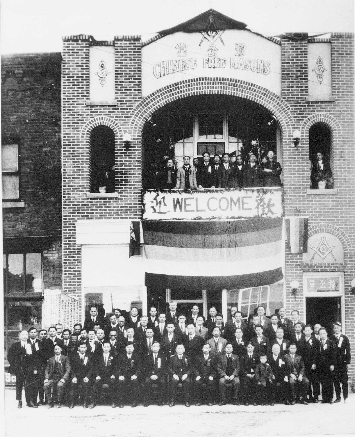
Since its construction in 1924, the Chinese Free Masons Building has been an anchor in the physical and social fabric of downtown Lethbridge and on of Alberta’s most intact historic “Chinatowns”. A large crack zigzags across the west wall of the Provincial Historic Resource and propagates east down the block, telegraphing through the walls of its historic neighbours and terminating at the old No. 1 Fire Hall. The crack recently presented repair challenges and is the legacy of a historic landscape and a transformed physical and cultural geography.
1990s photograph from the northwest with the west wall crack and previous repairs clearly visible toward the back (right) half of the building. Source: Historic Resources Management Branch.
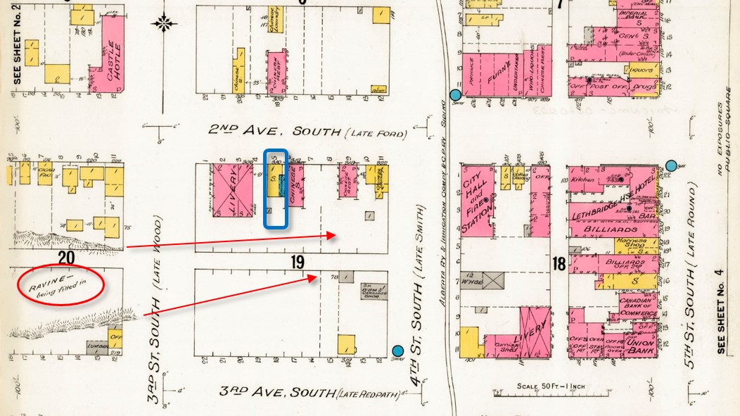
Some 12,000 years ago, as the Laurentide ice sheet retreated toward Hudson Bay, torrents of meltwater carved deep channels across southern Alberta, including today’s Oldman River valley. Long tributary coulees reached like fingers from the valley’s east side, a pattern evident today along the escarpment behind the Galt Museum. One of these coulees extended east between what is now 2nd and 3rd Avenue South and appears in early plans and photographs of Lethbridge. Uneven and difficult to build on, the block attracted Chinese immigrants and entrepreneurs who established new businesses on lots that were strategically close to the fledgling town centre but slightly apart from it, a development pattern reinforced by discriminatory policies of the day that relegated Chinese-owned businesses to marginal land away from the commercial core.
A fire insurance map of 1910 predates the construction of the Chinese Free Masons Building on Block 19 Lot 5 (blue outline) but notes infilling of the ravine or coulee (circle at lower left). Arrows indicate the original extent of the coulee eastward through Block 19. Source: Library and Archives Canada, with added annotations.
Development has infilled the coulee such that the historic landscape today survives only in the sunken rear lots of the Bow On Tong Company Building and Wing Wah Chong Company Building, both of which are Municipal and Provincial Historic Resources. These low-lying back yards were historically put to good use, providing direct access to basement apartments for newly arrived immigrants from China and serving as vegetable gardens (see banner image at top of page). Though hidden, the buried coulee survives as relatively weakly consolidated infill soil under the back portions of the block’s historic buildings. These areas move and crack as soil compacts, takes up water from the poorly drained rear lots, or moves seasonally where shallow rear foundations are susceptible to frost heave. The rear lot at the Chinese Free Masons Building has been infilled but unstable soil conditions persist and cause structural movement and recurrence of the west wall crack despite repeated patching.
1924 photograph, possibly showing the Masonic hall’s grand opening. Source: Galt Museum and Archives photograph 19800128000.
Foundation underpinning on deep piles into undisturbed soil would stop the structural movement and cracking but is very costly. A local architect assessed no immediate threat to the building and recommended a practical and cost-effective crack repair alternative. This consisted of saw cutting a new flexible control joint into the outer wythe or layer of brick beside the old crack, to accommodate ongoing structural movement while maintaining integrity as a weather seal. The existing crack was too irregular for proper installation of a reliable sealed joint. As a precaution, the established crack was also repaired with flexible sealant, into which masonry sand was pressed to resemble a traditional mortar joint and disguise the repair as much as possible.
Conservation work normally favours traditional materials but a deep mortar repair risked “locking” the wall in place and causing cracks to appear elsewhere. Correctly formulated lime mortars can absorb some movement and even “self heal” as free lime recrystallizes within emerging hairline cracks — but structural movement at the Free Masons Building demanded a more elastic joint.
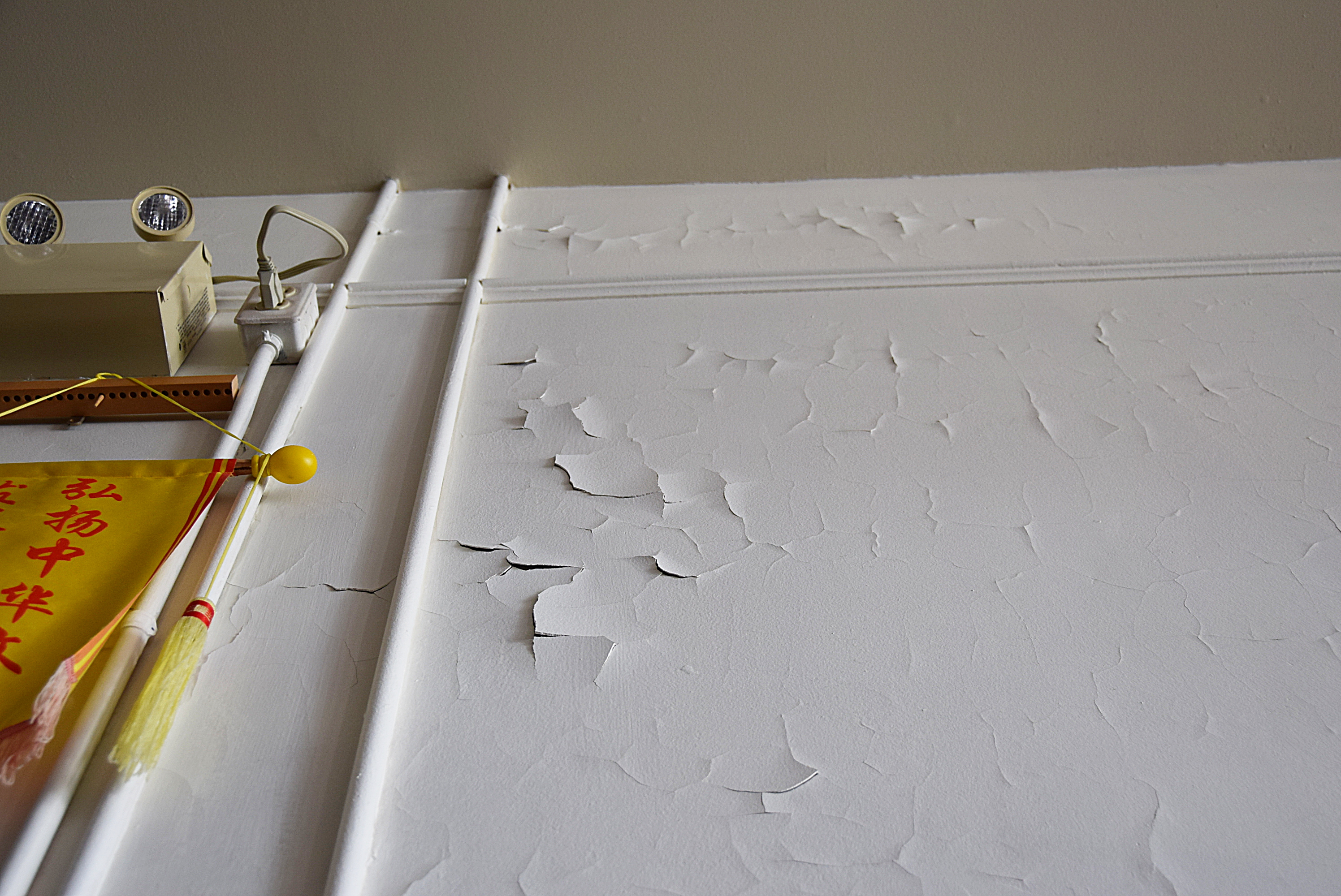
Paint failure on second floor interior west wall, April 2019. Source: Historic Resources Management Branch.
The second floor offers a large open space that has served as a Masonic hall for almost a century. The interior walls are original plaster applied to the interior face of the brick masonry exterior walls. Coated with many layers of paint, the walls deteriorated rapidly after the interior was repainted to hide smoke damage after a fire in 2009. Driving rain through the west wall crack was initially suspected as a moisture source but the extensive paint failure was actually in another location. Further assessment determined that the problem was excess moisture within the wall combined with the wall’s inability to dry through impermeable layers of paint.
The west wall is thus a highly porous brick that readily absorbs moisture. Like many old brick buildings, the Chinese Free Masons Building uses a high-quality, durable brick on the front facade with less expensive bricks on the side walls that were often intended to be protected by adjacent buildings. Mortar joints also play a role: lime mortar both binds the masonry and actively wicks moisture in the wall to the surface, where it then evaporates. However, as mortar weathers, leaching of the lime binder reduces this wicking action and eroded joints provide more surface area for water absorption, effectively turning a wall into a sponge. On the wall’s inner face, permeability declines with each layer of paint and as old alkyd paint ages. The most recent repainting was the last straw: acrylic latex paint is vapour-permeable but drying of the wall fabric relies on liquid (if microscopic) capillary moisture transfer. The result is that moisture absorbed through the exterior brick trapped within the wall literally pushes the paint off the plaster.
Second floor (Masonic hall) with far wall after plaster repairs and application of clay paint, March 2021. Source: Historic Resources Management Branch.
To correct the problem, peeling interior paint was stripped by hand and moisture-damaged plaster was patched with a compatible gypsum plaster free of latex or polymer additives that might otherwise impede prevent drying. A special, highly permeable clay-based paint was applied to the wall and colour-matched to the historic interior. Combined with renewing or “repointing” the exterior masonry with a compatible lime mortar, these measures avoid sealing the wall and instead restore the historic fabric’s intrinsic ability to absorb, buffer and release moisture by drying to the interior and exterior. The repaired west wall with its new control joint and evidence of the old crack are a testament to ancient landforms, local history and Lethbridge’s evolving urban landscape.
View from northwest in June 2021 with new control joint on west wall and muted expression of historic crack. Source: Historic Resources Management Branch.
Sources:
C.B. Beaty and G.S. Young, The Landscapes of Southern Alberta: A Regional Geomorphology (Lethbridge: University of Lethbridge, 1975), 66-77.
For a discussion of the early development of Lethbridge’s Chinatown, see David Chuenyan Lai, Chinatowns: Towns Within Cities in Canada (Vancouver: University of British Columbia Press, 1988), 90-91.
Editor’s note: Starting July 3, the National Trust for Canada is hosting Historic Places Days. All next month, RETROactive will feature blog posts highlighting places to explore and events to participate in.
Written by: Jared Majeski, Historic Resources Management Branch
After more than a year of being shuttered, historic sites and museums around Alberta are beginning to reopen. And with some restrictions and caution around traveling, it’s the perfect time to go head out and explore the sites right in your own backyard!
While some self-guided sites like the Okotoks Erractic, Brooks Aqueduct and Frog Lake Provincial Historic Site have been accessible for several months now, some of the larger historic sites, museums and interpretive centres are now ready to open their doors. Below is a quick roundup of reopened historic sites; click on the visitor guideline links to learn how each site is keeping visitors and staff safe.
Frank SlideInterpretive Centre
Located in the stunning Crowsnest Pass, the interpretive centre tells the story of Canada’s deadliest rock slide. Visitor guidelines
Head-Smashed-In Buffalo Jump
Through vast landscapes, diverse programming and exhibits, you can experience 6,000 years of Plains Buffalo culture at this UNESCO-designated World Heritage Site. Visitor guidelines
Provincial Archives of Alberta
The archives acquires, preserves and publicly makes available records from government, individual people and organizations for researchers of all ages. Along with the PAA opening its doors to the reading room again, they are also unveiling a brand new exhibit about the history of beauty competitions and pageants in Alberta. Visitor guidelines
Remington Carriage Museum
The largest museum of its kind in the world, the Remington Carriage Museum tells the story of horse-drawn transportation in North America. Visitor guidelines
Reynolds-Alberta Museum
Located in Wetaskiwin, the Reynolds-Alberta Museum interprets Alberta’s mechanical heritage through authentic interactions, exhibits and hands-on programming. Visitor guidelines
Royal Alberta Museum
The Royal Alberta Museum (RAM) is the largest museum in western Canada and one of the top museums in Canada. Located in the Arts District in downtown Edmonton, the museum helps to collect, preserve, research, interpret and exhibit objects and specimens related to the heritage of Alberta’s people and natural environment Visitor guidelines
Royal Tyrrell Museum of Palaeontology
The Royal Tyrrell Museum of Palaeontology is Canada’s only museum dedicated exclusively to the study of ancient life. In addition to featuring one of the world’s largest displays of dinosaurs, the museum offer a wide variety of creative, fun, and educational programs that bring the prehistoric past to life. Visitor guidelines
Ukrainian Cultural Heritage Village
A short drive east of Edmonton, at the Ukrainian Cultural Heritage Village you’ll hear stories of solitude, survival, and perseverance while discovering how Ukrainian immigration made a significant impact on Alberta’s cultural identity. Visitor guidelines
Editor’s note: Abawashded!June is National Indigenous History Month, an invitation to honour the history, diversity, strength and contemporary achievements of Indigenous peoples.
Written by: Barry Mustus (Alexis Nakota Sioux Nation) and Laura Golebiowski (Aboriginal Consultation Adviser)
Like many Albertans, I have spent a considerable portion of the last year outdoors. I have become better acquainted with my neighbourhood and city parks, and have spent most weekends hiking, camping or cross-country skiing in the mountains. I am grateful to be in a position (both in terms of privilege and location) to access the diverse and beautiful outdoor spaces that our province provides.
When you recreate outdoors, do you consider whose traditional territory you are on? Do you think about those who walked these trails and enjoyed these landscapes before you?
Barry Mustus does. An Alexis Nakota Sioux Nation member currently based in Whitecourt, Barry has dedicated numerous years to the research and reidentification of a historic Indigenous trail network which extended from Lac Ste. Anne north to Whitecourt and beyond. To date, Barry’s work has focused on a 30 km stretch of trail from the Hamlet of Blue Ridge, southeast of the Town of Whitecourt, to Carson-Pegasus Provincial Park. Referring to the trail as, “The Nakota Trail of 1877” (the year Alexis Nakota Sioux Nation signed an adhesion to Treaty 6), Barry’s efforts strive to demonstrate how Nakota peoples have shaped, and continue to shape, this region of what is now Alberta.
The Stoney people, also referred to as the Assiniboine, have long occupied this area. In 1859, James Hector, a companion of Captain John Palliser, noted a group of Stoney camping at the confluence of the McLeod and Athabasca Rivers, where present-day Whitecourt is located. Earlier still, fur trader Alexander Henry makes mention of a Stoney presence in the Upper Athabasca in 1808. Today, Alexis Nakota Sioux Nation is the most northwestern representative of the Siouan language family and has four reserves: the largest at Glenevis near Wakamne (Lac Ste. Anne) with three satellite reserves at Cardinal River, Elk River and Whitecourt.
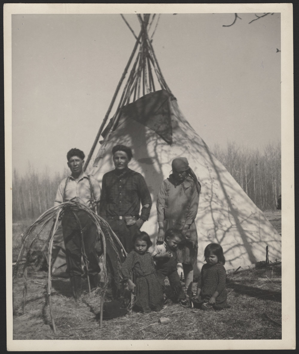
Alexis Nakota Sioux Nation Family, Peter Alexis and Wife, Lac Ste Anne. Unknown photographer or date. Source: Library and Archives Canada.
Written by: Ron Kelland, Geographical Names Program Coordinator
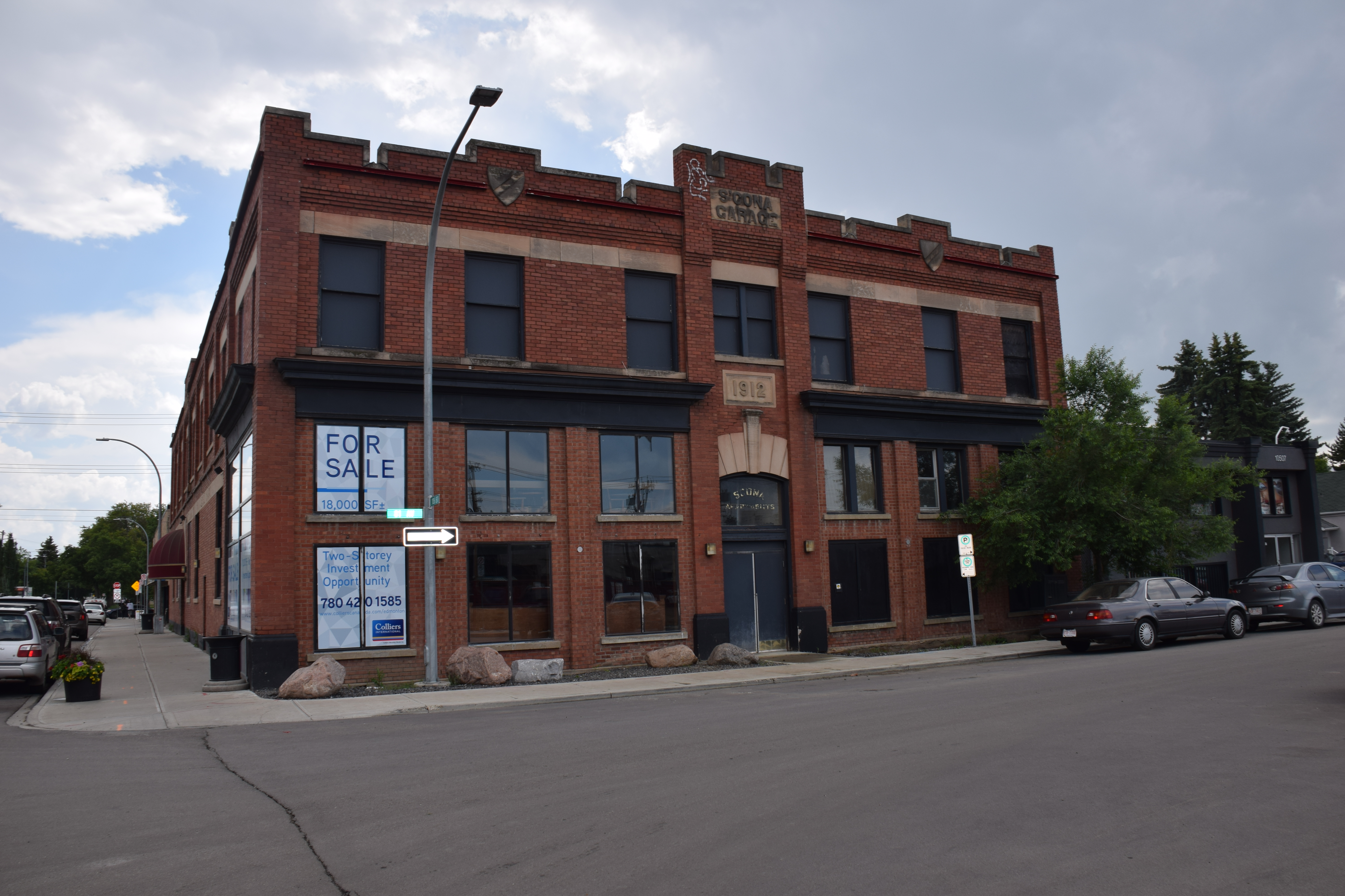
A well-known anchor building in Edmonton’s Old Strathcona Provincial Historic Area has recently been designated as a Provincial Historic resource. And it’s also now listed on the Alberta Register of Historic Places.
Front (north-facing) façade of the Strathcona Garage showing some of the building’s character-defining elements, notably the crenellated parapet roofline, escutcheons and the contrasting ornamental highlights (lintels, sills, name and date stones), 2019. Source: Alberta Culture, Multiculturalism and Status of Women.
The Strathcona Garage is located in Edmonton’s Old Strathcona neighbourhood on the corner of lot at 81 Avenue and 105 Street. Its heritage significance rests in its association with the early automobile industry in Alberta. It is a significant and rare remaining example of a building from the early twentieth century designed and built specifically for the era’s fledgling, but rapidly growing automobile sector.