An important mandate of the Archaeological Survey section of the Historic Resources Management Branch is to undertake extra-regulatory public outreach projects and research initiatives. The staff at the Survey have been busy this last year pursuing this goal. Some of the projects and activities that have taken place, or are underway now, are highlighted below.
Part of this goal includes delivering programs that address Albertan’s desires to learn about their heritage and widen appreciation for Alberta’s archaeological resources. Youth outreach was done through the delivery of eight school programs to elementary and junior high school students. Darryl Bereziuk, Director of Archaeological Survey, and Blair First Rider, Aboriginal Consultation Adviser, presented to students at Leo Nickerson Elementary School in St. Albert; Todd Kristensen, Northern Archaeologist, presented to 6 classrooms as part of the U School Education Program at the University of Alberta; and Wendy Unfreed, Plains Archaeologist, participated in a youth apprenticeship field program for Dr. Swift Junior High School in Lac La Biche. Read more →
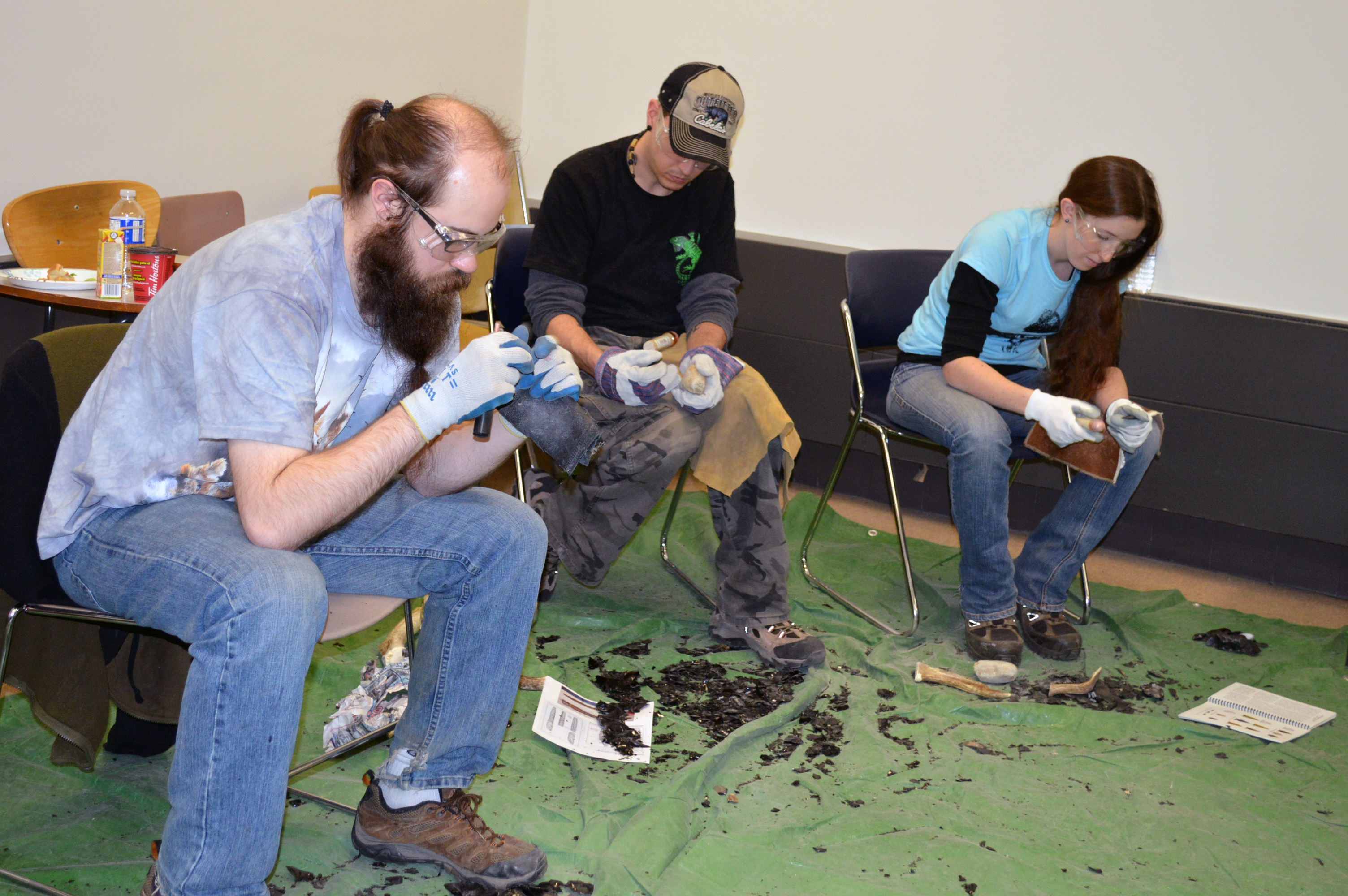
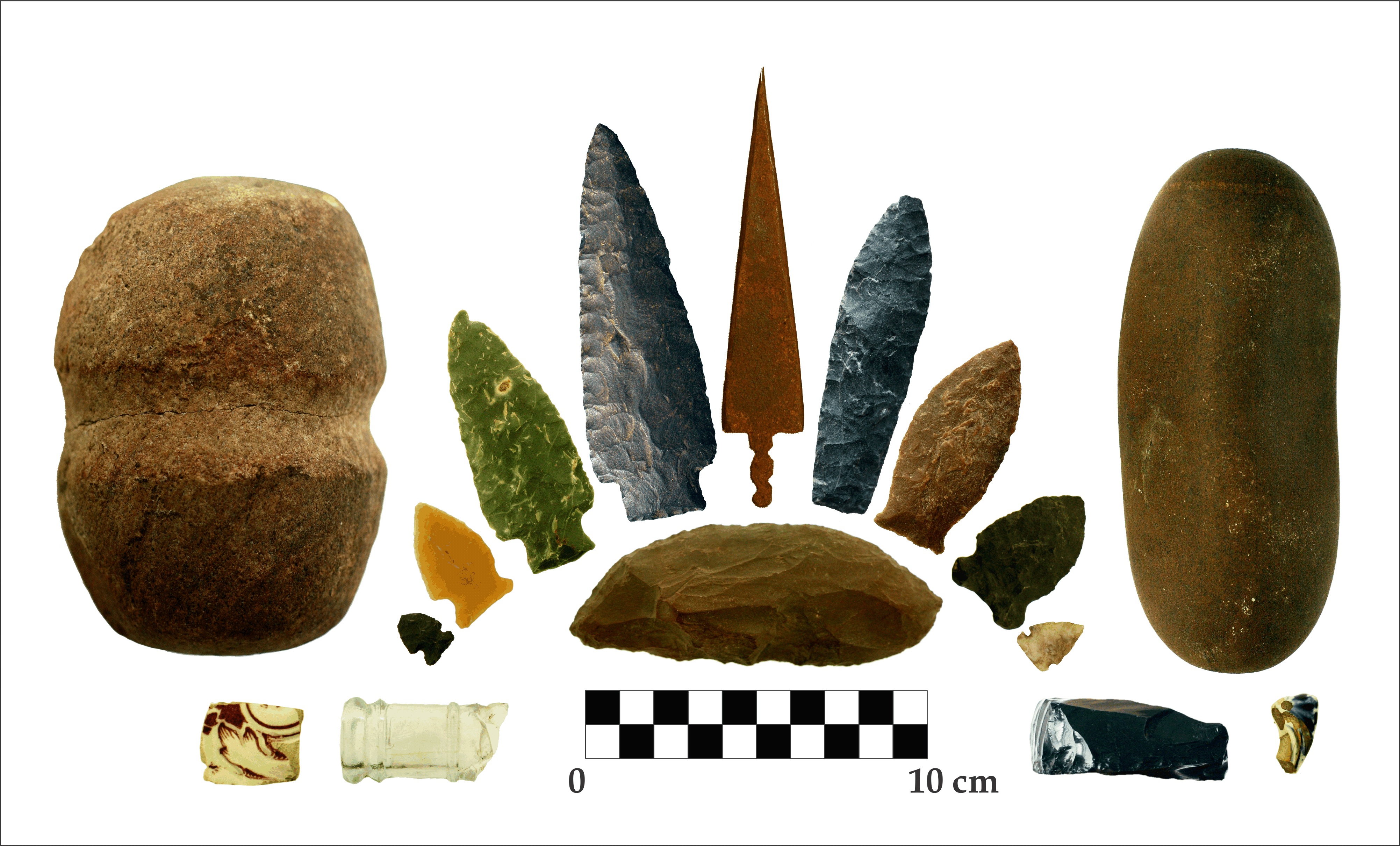
In March the Strathcona chapter of the ASA held a flint-knapping and tool-making workshop in Edmonton. The ASA workshop allowed members to get first-hand experience making the stone, or lithic, tools that are among the most common artifacts found in archaeological sites in Alberta. Prior to the arrival of metals with Europeans in North America, First Nations people created tools such as blades, knives, axes, and projectile points, by knapping stones. Knapping technology is not unique to Alberta, but was used by humans and our ancestors in all parts of the world beginning as early as 3.3 million years ago in Africa. Today many archaeologists practice knapping to better understand the material culture recovered from archaeological sites. Knapping is also a common hobby among archaeologists and non-archaeologists alike.
Creating Stone Tools
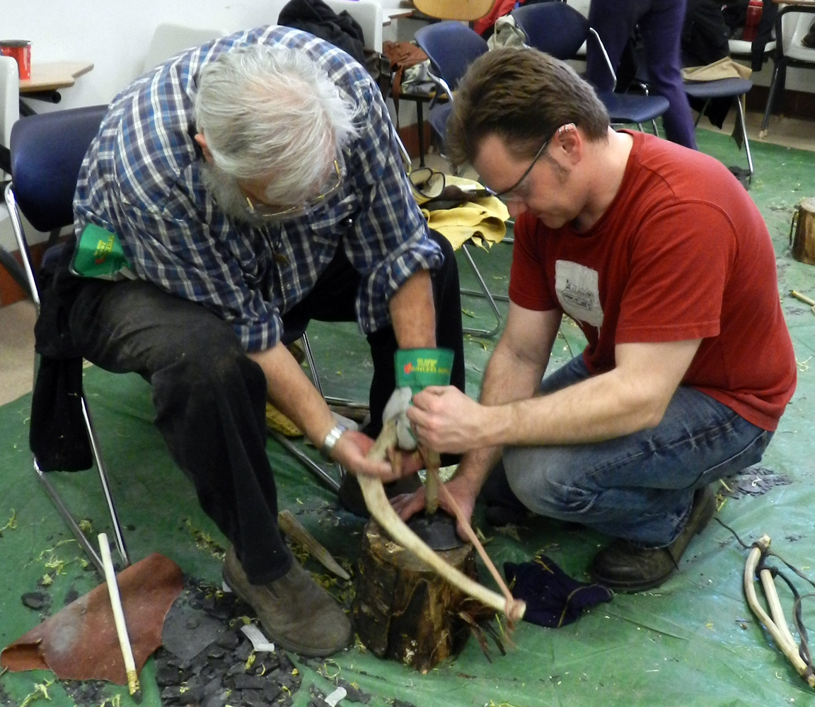
First, cores of lithic raw material are precisely broken using hammerstones (stones and antler) to produce large, flat flakes. At the workshop, participants knapped obsidian and dacite, two types of stone that are easy to use for beginners. When knapping, safety is always top priority. Striking stones such as obsidian produces tiny shards of the material, which tend to scatter and can easily cause injury. To prevent accidents, knappers use hand and eye protection, and always have plenty of bandages at the ready. The scattered waste flakes produced when knapping are called ‘debitage’ by archaeologists.
ASA participants using hammerstones to produce lithic (stone) flakes and debitage.
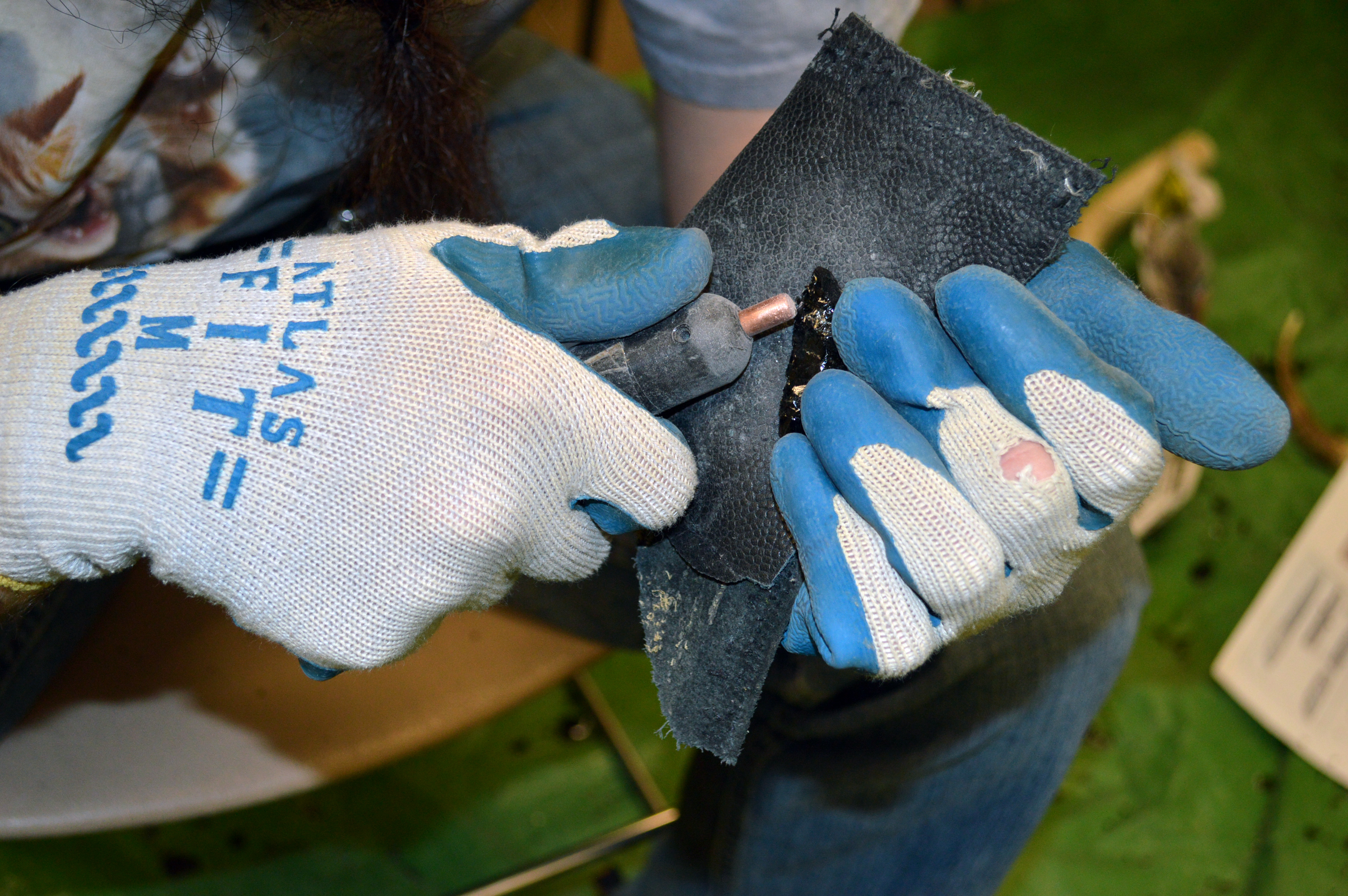
Next, smaller flakes of stone can be worked into tools. Instead of striking the stone, smaller flakes can be removed by applying consistent force in a process called pressure flaking. In the picture below, a knapper is using a copper pressure flaker to work the edge of a projectile point.
A knapper using a copper pressure flaker to work the edge of a projectile point.
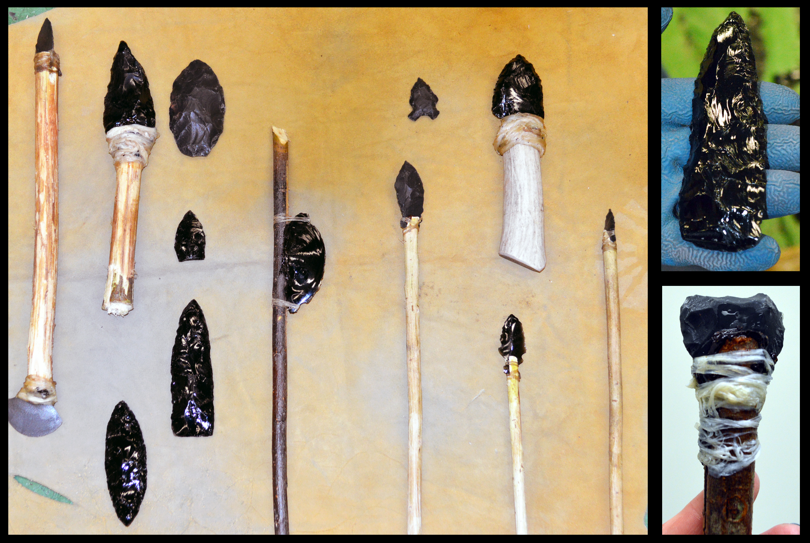
Finally, the knappers were able to haft their new tools onto wood or antler shafts and handles. The stone tools were affixed into the wooden handles using pine pitch, and then fastened using animal sinew and hide glue. In archaeological sites the organic shafts, handles, and fastening materials have usually decayed, leaving only the stone tools behind.
Some of the tools created at the ASA Flint Knapping workshop
Becoming a good knapper takes a lot of patience and practice, and it helps to have a good teacher. If you are interested in learning how to knap stone tools, there will be two knapping events in Alberta this year in July and September.
Written by: Colleen Haukaas, Archaeological Permits & Digital Information Coordinator.
In 1973, the Government of Alberta assumed a central role in the management of archaeological research. In the 42 years since then, the Archaeological Survey at Alberta Culture and Tourism has been busy. More than 9,000 archaeological research permits have been issued and as a result, archaeologists have discovered over 40,000 archaeological sites in Alberta.
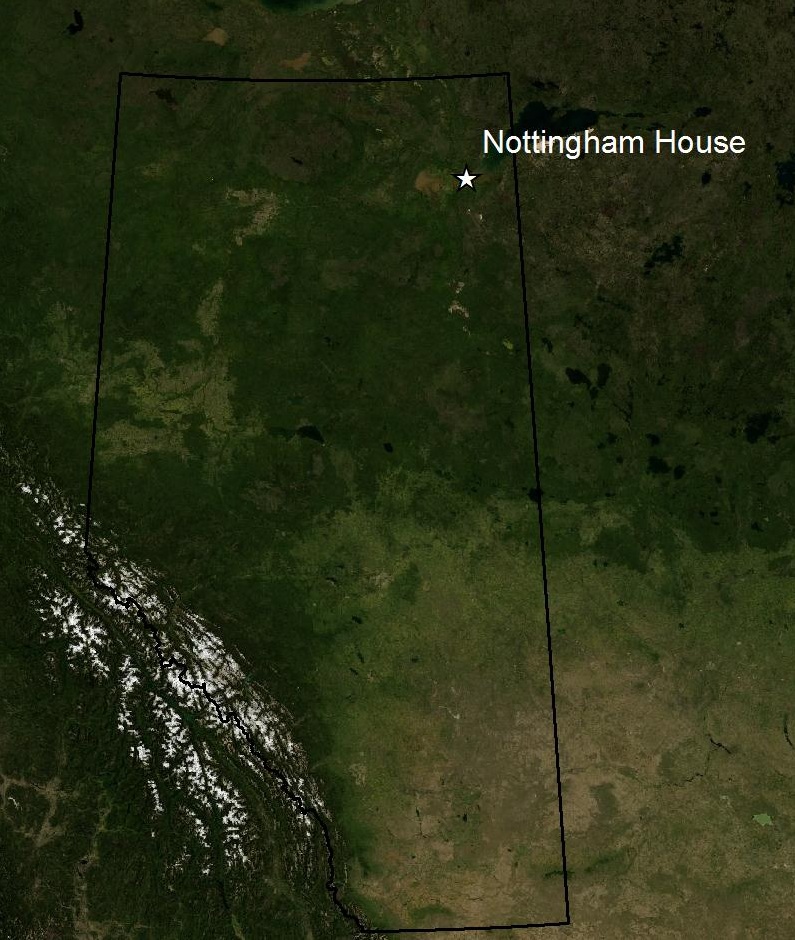
So where did it all begin? The first archaeological research permit in the province was issued to Karlis Karklins in 1973 by Alberta Culture, Youth, and Recreation. The permit was for his research at Nottingham House, a Hudson’s Bay Company trading post near Fort Chipewyan, as a part of the Western Fur Trade Research Programme. The programme was initiated by Parks Canada in 1968 to explore the history and archaeology of the fur trade in the Athabasca region. As part of that project, Karklins began researching Nottingham House in the early 1970s.
Historical Setting
Nottingham House was a fur trade post established by the Hudson’s Bay Company (HBC) in 1802. The HBC hoped to compete with the North West Company (NWC), who held a 20 year monopoly on the famed fur-rich areas of the Athabasca region. Peter Fidler, an experienced HBC surveyor, along with his Swampy Cree wife, Mary, their children and 17 other explorers arrived at Fort Chipewyan in late 1802 to set up the new trading post, Nottingham House. In the style of competitive exploration that characterized the fur trade in western Canada, Nottingham House was erected less than a mile from Fort Chipewyan, a successful NWC trading post established in 1788.
Despite the best intentions of the HBC and Fidler’s crew, Nottingham House was not a successful trading post. The NWC at Fort Chipewyan took every chance to sabotage trade at Nottingham House, even going so far as to burn HBC canoes and to have individuals that were known to trade with the HBC beaten. In their first year, the HBC at Nottingham House generated a return of only six bundles of fur, which did not come close to covering the costs of their expedition. Fidler and his company remained at Nottingham House for four years, during which they struggled with dwindling trade, starvation and increasingly aggressive attacks from the NWC. On June 9, 1806, Nottingham House was abandoned and the HBC traders moved on to other posts.
Archaeological Research
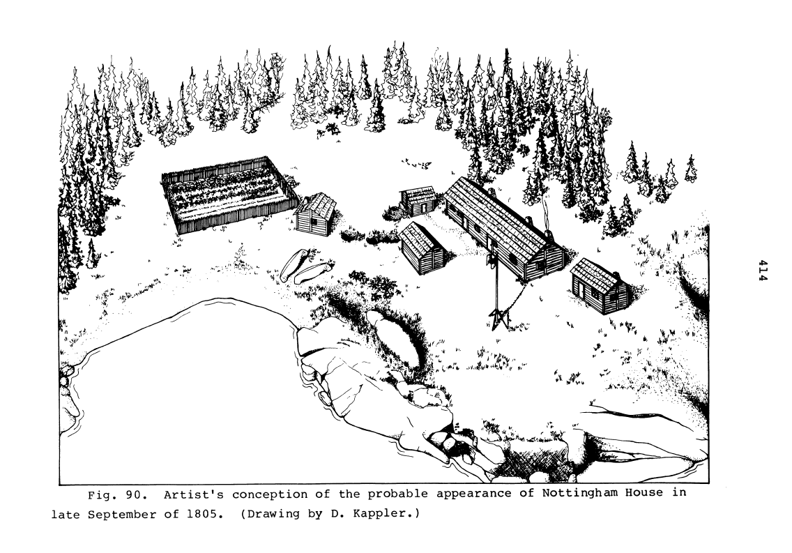
The Nottingham House archaeological site was excavated by Karklins, an employee of the National Historic Parks and Sites Branch of Parks Canada during the 1970s. Karklins and seven others began their first 14-week excavation season in June 1972, returning for a lengthy field season each summer until 1977.
The archaeological crew unearthed just over 1,072 square meters of the site, revealing the remains of several buildings and work areas. The main house, measuring about 15 meters by 5 meters, was made up of four rooms with fireplaces, storage pits and a cellar. The site surrounding the main house included a storehouse, a provisions shed, a garden and several outdoor working areas, storage pits and trash pits. The structures were made from the locally-available wood, stones and clay. Most of the structures showed evidence of burning, which suggests that the NWC may have burned the camp after the HBC abandoned it in 1806.
The archaeology crew also uncovered 5,707 complete artifacts and a further 1,006 broken fragments of artifacts during their field seasons. The artifacts are typical of a fur trade post from that era. Most artifacts were personal items that would have been used by those living at the post or were kept as items for trading. These included beads, combs, mirrors, books and glass and ceramic containers.
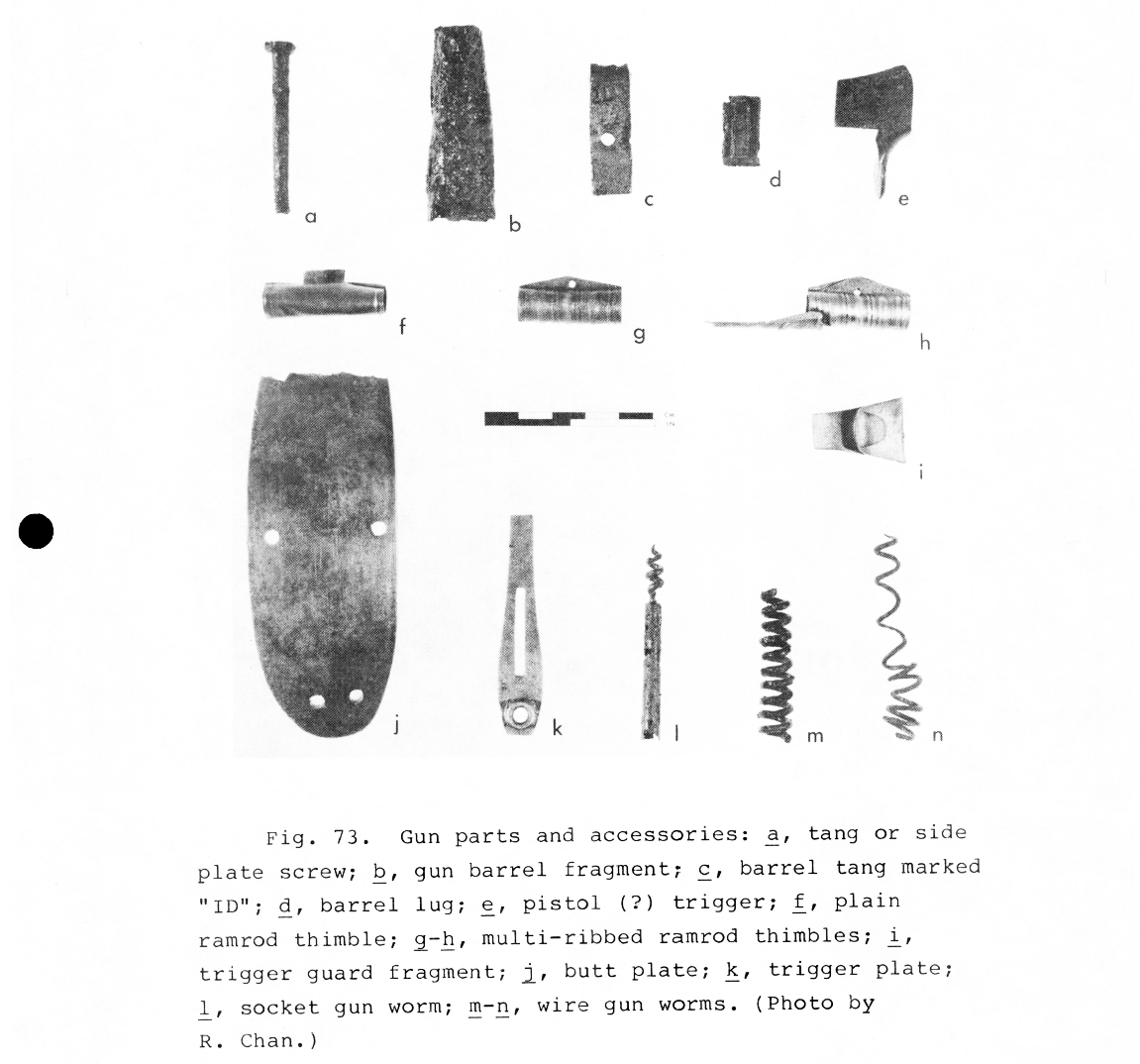
The other artifacts reflect what would be needed to construct and maintain a fur trade post in undeveloped territory in 19th century Boreal Forest Alberta, such as tools and hardware (axes, nails and saws), hunting and fishing gear (gun parts and ammunition) and household items (cookware, furniture and sewing supplies). The historical record suggests that the HBC crew relied on a protein-rich diet, consisting mostly of animals and birds such as moose, bison, caribou, dog/wolf, snowshoe hare, swans, ducks and cranes that were traded from the local Aboriginal population. Other animals identified from the faunal remains included Arctic fox, muskrat, marten, wolverine and lynx, all of which were hunted for their furs and may have been eaten as well. The crew was also able to fish in Lake Athabasca and grow potatoes and turnips in their gardens.
Examples of gun parts and accessories that were found by Karklins at the Nottingham House archaeological site.
Karklins’ research in the 1970s served to build a better understanding of the economy and material culture of the Nottingham House fur trade post. The site has not been excavated by archaeologists since the 1970s, but Karklins’ research has proved valuable for other archaeologists and historians studying the fur trade in western Canada, and especially in the Athabasca region of Alberta. The archaeological site of Nottingham House remains protected by the Historical Resources Act as an Alberta Significant Archaeological Site.
References and Figures: Karklins, K. (1979). Nottingham House: The Hudson’s Bay Company in Athabasca, 1802-1806 (Doctoral dissertation, University of Idaho).
Written by: Colleen Haukaas, Archaeological Permits & Digital Information Coordinator.
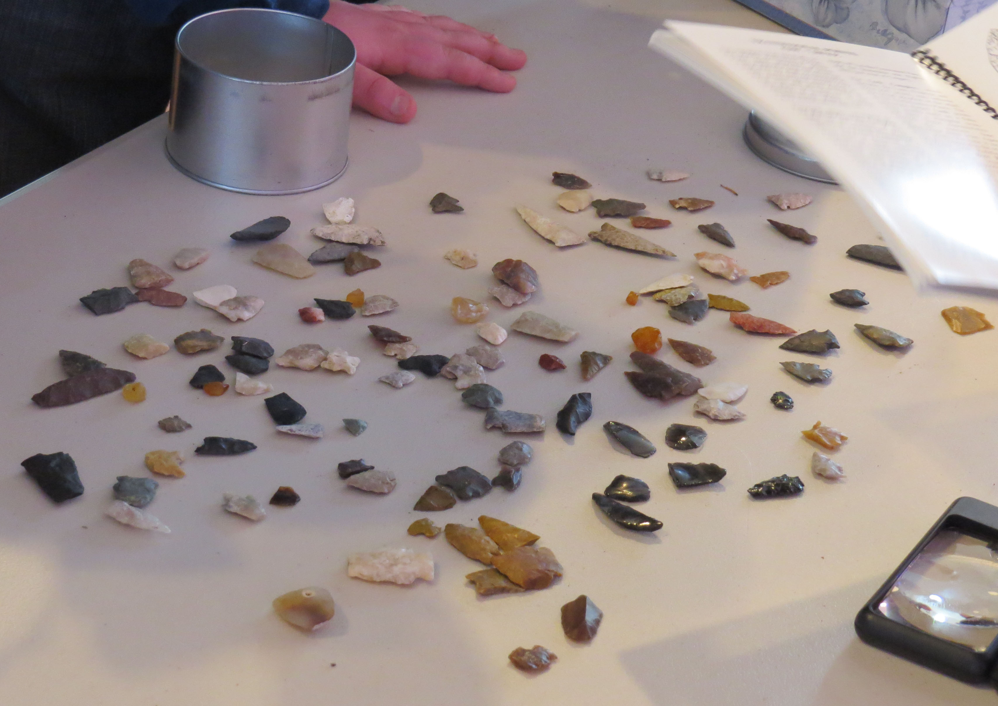
Have you ever discovered a projectile point, stone tool, ceramic, bone or other archaeological artifact? If so, we want to hear from you!
A variety of artifacts typically found in Alberta. Photo credit: Todd Kristensen.
Archaeological artifacts may be exposed by natural events (flooding, freeze/thaw cycles or tree throws) or human modification to a landscape (agriculture, recreation activities or development). As explained in a previous post, Alberta is Rich in Archaeology, archaeologists working in the province discover, or revisit, sites during the course of Historical Resource Impact Assessments. However, there are large stretches of the province that are not subject to Historical Resource Impact Assessments such as previously cultivated areas or areas that do not have development projects on them. This doesn’t mean there are not archaeology sites there. Often, people will discover archaeological artifacts and sites when they are out hiking, fishing, geocaching, working or cultivating their fields. This can include arrowheads or other stone tools, bones, ceramics or tipi rings and other stone features. So, what can people do when they make these discoveries? They can Report A Find!
Bone artifact from a “Stones and Bones” event in Coaldale. Photo credit: Royal Alberta Museum.
The Archaeological Survey has set up a webpage where people can report their discoveries. You can get an expert opinion on your find and, who knows, possibly be credited with recording a new archaeological site! Recording this information is a big step in helping to preserve and protect Alberta’s historical resources. But, please remember that if you observe an artifact in your travels, the best practice is to leave it where you found it. Archaeological sites are protected under Alberta’s Historic Resources Act, regardless of where they were found. Removing an artifact from its original context disrupts the integrity of the site and may hinder efforts to further understand the significance of the object. You just need to provide us with a photo of your find and the location it was found, either by providing geographic coordinates or plotting the location on a map. Your find will be reported to staff at the Archaeological Survey and they will follow up with you and possibly ask for additional information. Staff will confirm if the site is already known or if the find warrants a new site designation!
Medicine Wheel with outer rings and a central cairn. Photo credit: Royal Alberta Museum.
Reporting finds can provide valuable information that helps the staff at the Archaeological Survey manage, protect and preserve archaeological resources in Alberta. We can’t wait to hear about your discoveries!
Written by: Courtney Lakevold, Archaeological Information Coordinator.
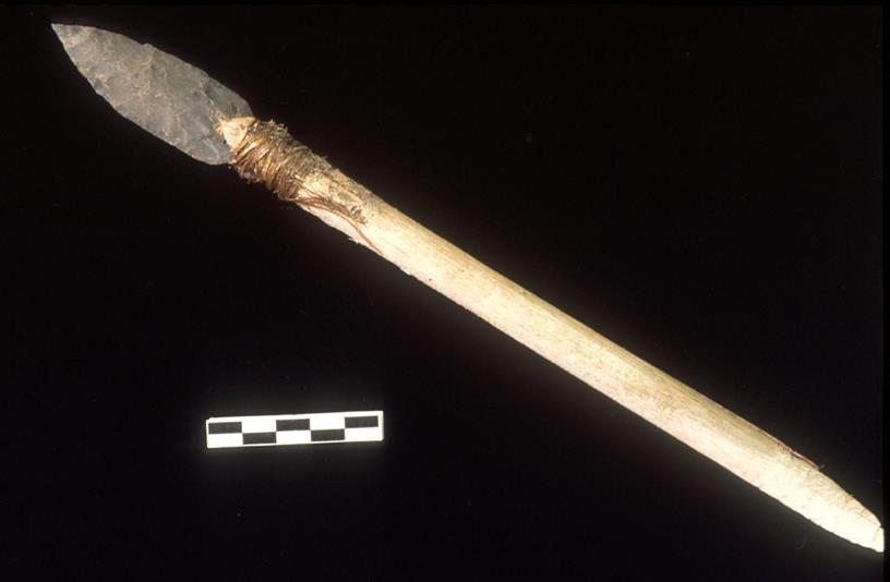
Recent archaeological research from Alaska to Yellowstone has revealed rare and delicate tools preserved in high altitude ice that tell of a deep human history in some of the most remote alpine habitats on the continent. These artifacts were lost by ancient hunters of alpine animals (like caribou and sheep) and had been encased in a barrier of ice that warming temperatures have recently unlocked. A race is now on to find frozen relics from the past before they, and the icy archives that house them, disappear.
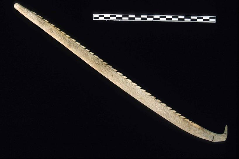
This stone dart is over 4000 years old and is preserved in its original wooden shaft (courtesy of the Government of Yukon).
The story of prehistoric alpine hunters in North America owes its existence to Yukon biologists who discovered an odd piece of wood above the treeline. The find was reported to local archaeologists who realized that it was a wooden tool lost on the ice thousands of years ago. First Nations across the North still remember stories of traditional life in the alpine, but until that lucky Yukon find, archaeologists didn’t expect that much physical evidence of old activities could be preserved in the harsh high altitude conditions. It is very rare to find wooden tools that are thousands of years old, so the artifact triggered a series of research programs in the North.
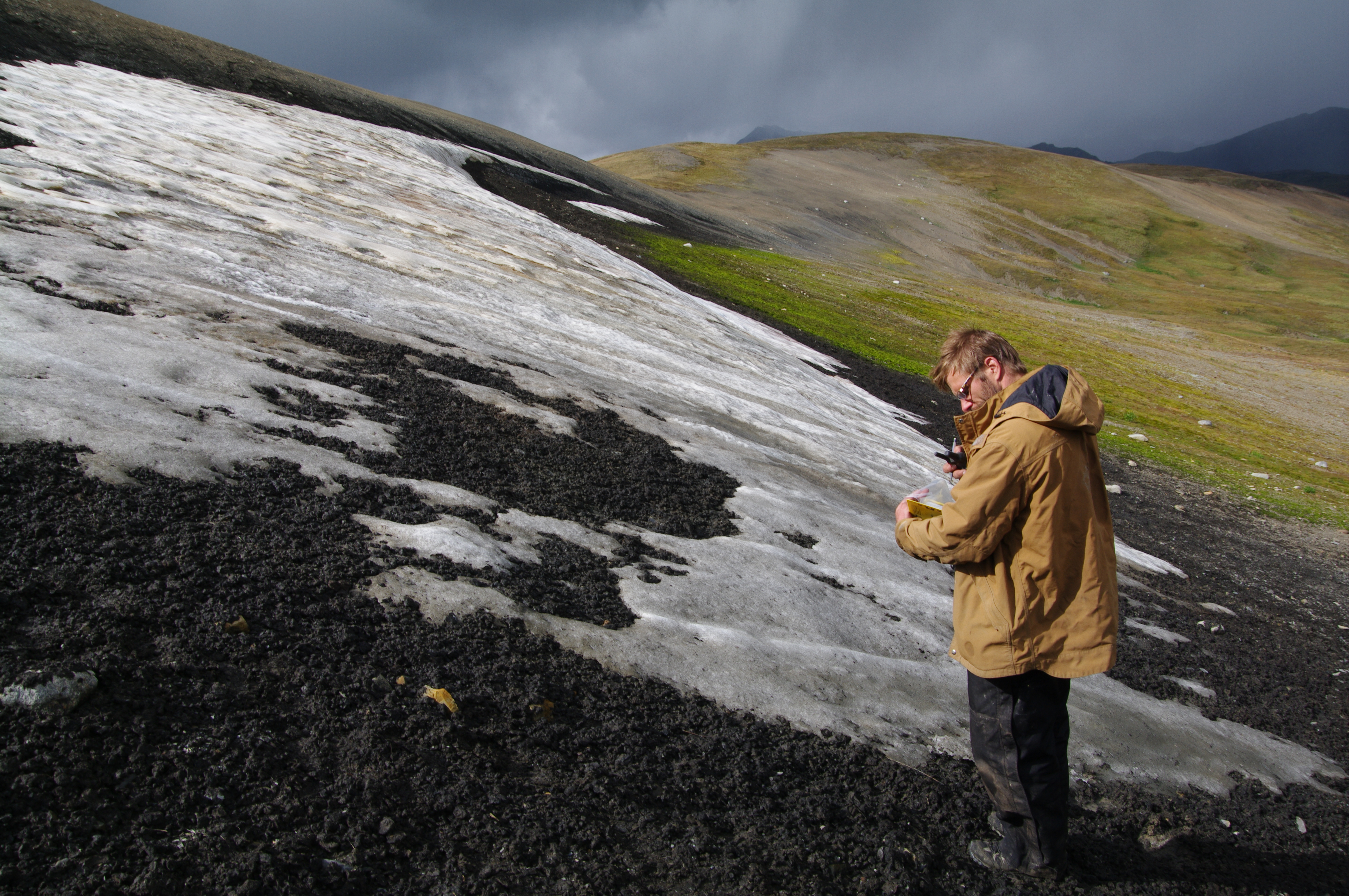
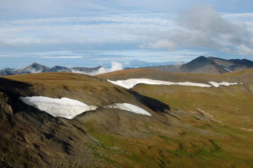
An archaeologist (Todd Kristensen) surveying a melting ice patch for artifacts (courtesy of Mike Donnelly).
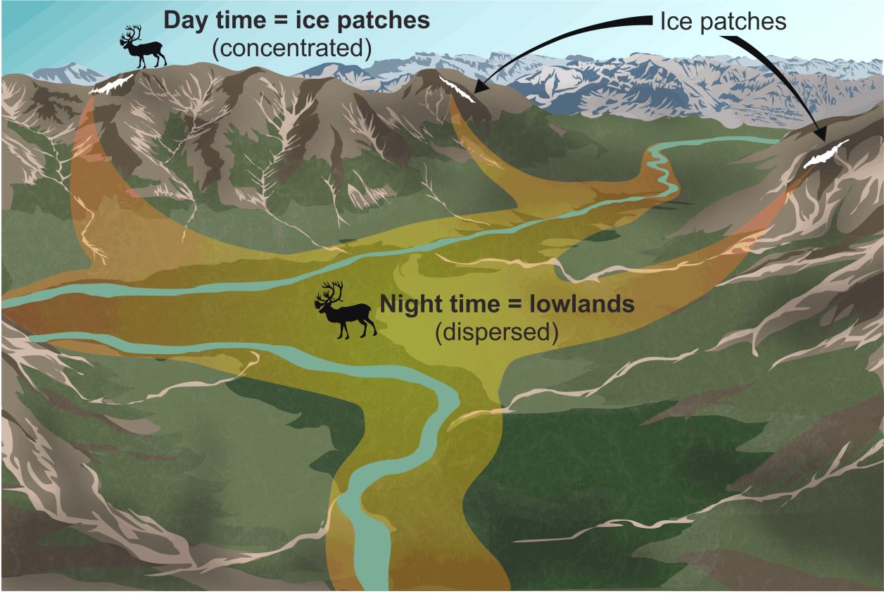
On a daily basis, caribou migrate upslope to colder heights during the hottest time of day only to return to the valleys at night. Alpine ice features provide animals relief from insects and hot temperatures. This long-lived habit of ice patch use makes these animals predictable. And so, as long as caribou and other animals have been gathering at ice patches in the North (for over 9000 years), people armed with sturdy moccasins and stone-tipped weapons have followed them.
Caribou gather on the upland ice features to stay cool in the midday heat (Todd Kristensen).
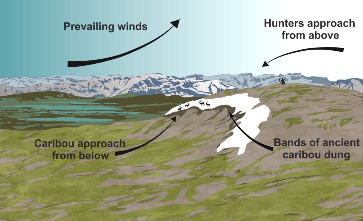
The perfect ice patch borders a round top that enabled hunters to lurk from above undetected (Todd Kristensen).
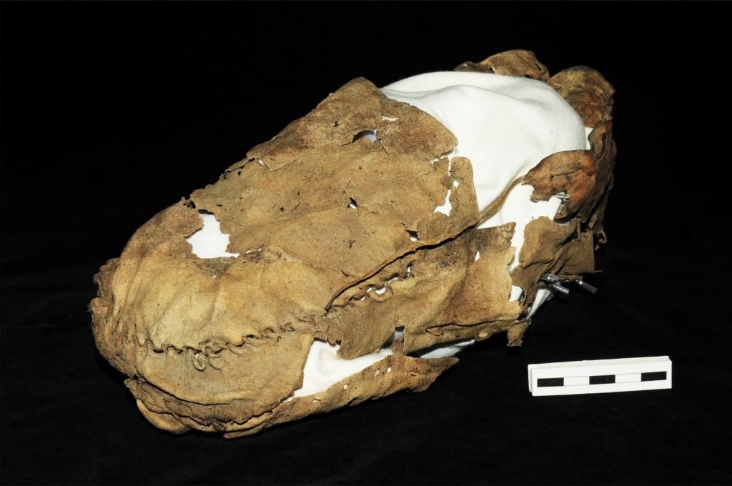
Archaeologists have found remnants of prehistoric hunting trips including possible broken spear shafts near Jasper, arrows, bows, darts, and an excellently preserved 1400 year old Yukon moccasin. Some arrows even retain the feathers that were tied to their shafts, which helped create drag that kept the arrows flying straight. (This is called ‘fletching’ and is the origin of the common European surname ‘Fletcher’. Arrowmaker is also a common First Nations family name for this reason.)
This moccasin held the foot of an alpine climber over a thousand years ago (courtesy of the Government of Yukon).Modern science is pin-pointing the materials used in ancient weapons (Todd Kristensen).
Archaeologists in N.W.T. have also found a snare in an alpine ice patch that was used to capture ground squirrels, the skins of which were stitched together to form beautiful robes. Based on First Nations traditional knowledge, up to 200 snares were set in a single alpine area and this could produce enough food to last for months. Add to this the supply of caribou, sheep, ptarmigan, and berries, and alpine life from late summer to early fall was good.
This barbed lance is a carved piece of antler from a Yukon ice patch (courtesy of the Government of Yukon).
Ice patches that lasted for over four millennia have vanished in the last 50 years and scientists are monitoring the implications for alpine ecology. While the causes of ice retreat are debated, the impact on the archaeological record is clear. Melting ice has unlocked a story of prehistoric hunting but at the same time, it has exposed those very clues of the ancient past to destructive high altitude weather. A book is opening and quickly closing and much remains to be learned before the fragile alpine artifacts decompose. If modern climbers find old bones, wood, or a potential artifact, please leave them in place and contact the authors with some photographs or map coordinates so we can continue to learn about the deep past of life in the alpine.
Ice patches in the North West Territories. (Tom Andrews, Government of N.W.T.).
A full version of this article appeared in the October issue of Alberta Outdoorsmen.
Written by: Todd Kristensen (Northern Archaeologist, Alberta’s Archaeological Survey); Tom Andrews (Territorial Archaeologist, Prince of Wales Northern Heritage Centre;, and Darryl Bereziuk (Director, Alberta’s Archaeological Survey)
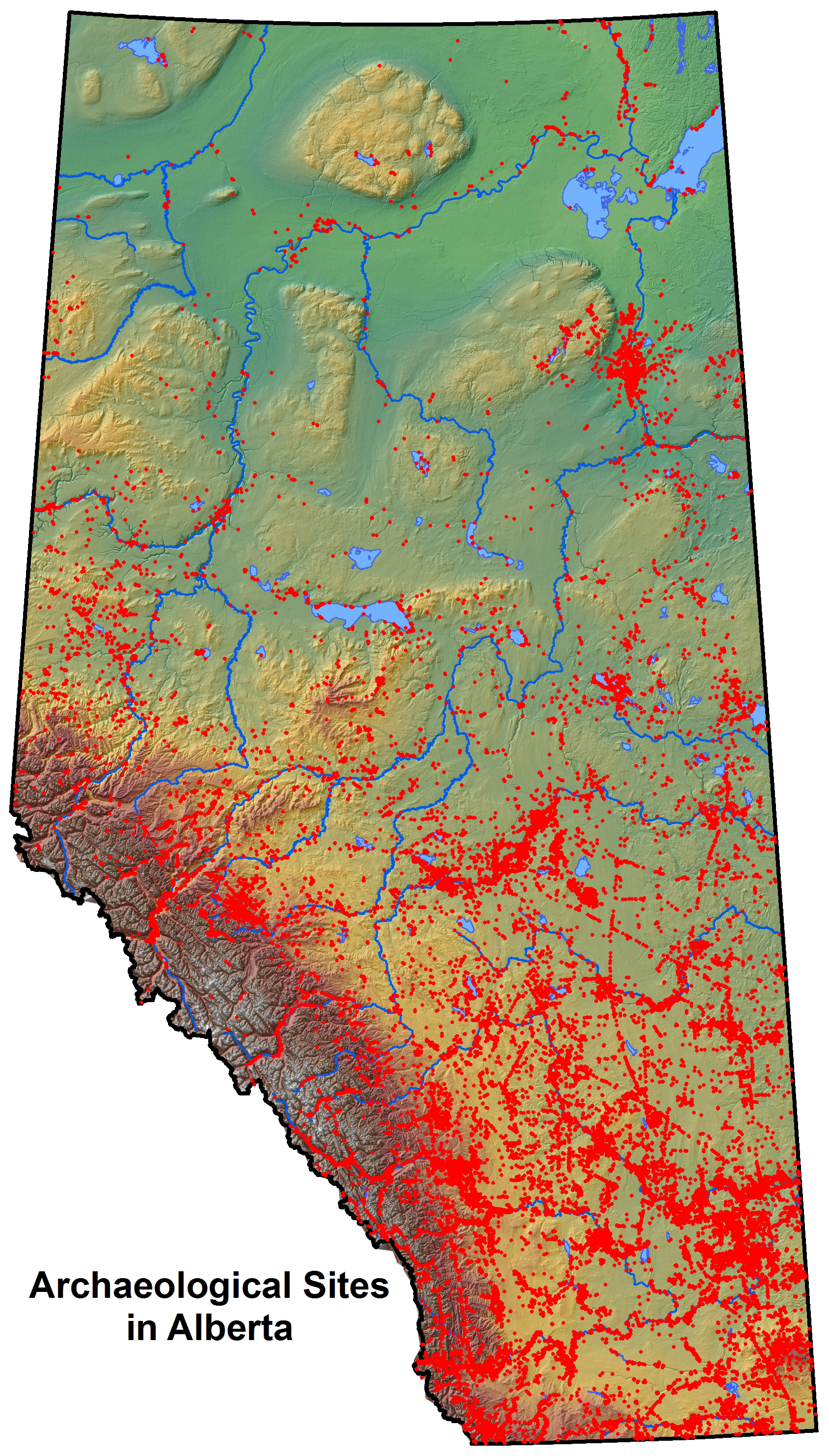
Distribution of archaeology sites in Alberta, December 2014.
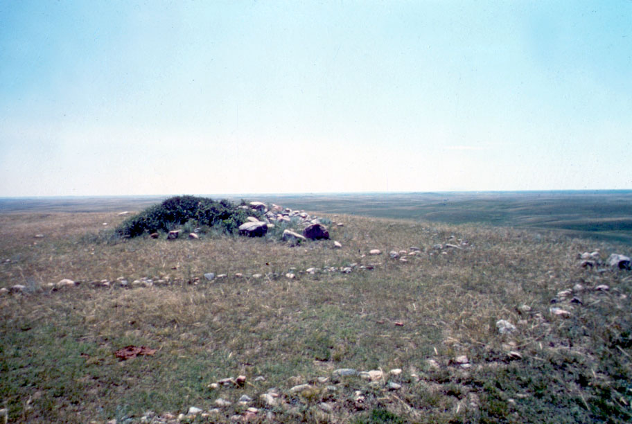
An archaeological resource in Alberta is defined as “a work of humans that is of value for its prehistoric, historic, cultural or scientific significance” and is protected under the Historical Resources Act. Sites are classed into two major groups: prehistoric and historic. Over 80% of the sites in the province are prehistoric (which predate the arrival of Europeans); just over 10% are historic (postdating European arrival); and the rest are a mix of both prehistoric and historic, contemporary, indigenous historic (such as Metis sites), and natural sites. Some of the most common prehistoric sites are campsites; stone features; animal kill sites; processing sites; rock art sites and ceremonial sites, such as medicine wheels and cairns. Historic sites include trading posts, police posts, early settlements, homesteads, and industrial sites.
Some of the oldest archaeological sites in Alberta date to as early as 13,000-8,000 years ago or what is known as the Palaeoindian Period. Prior to ~13,000 years ago what is now Alberta was covered by massive ice sheets that rendered the landscape uninhabitable. Shortly after the retreat of the ice sheets, however, animals and then people began moving into the area. At a site called Wally’s Beach in southern Alberta, archaeologists have recorded mammoth, camel and horse tracks. Not only that, they have discovered direct evidence of humans hunting these animals! Since then, what is now Alberta has been continuously occupied by numerous cultural groups, whose remnants we find in the form of discarded stone tools, butchered animal bones, hearths, broken pottery, buried palisade walls from forts and various other artifacts and features.
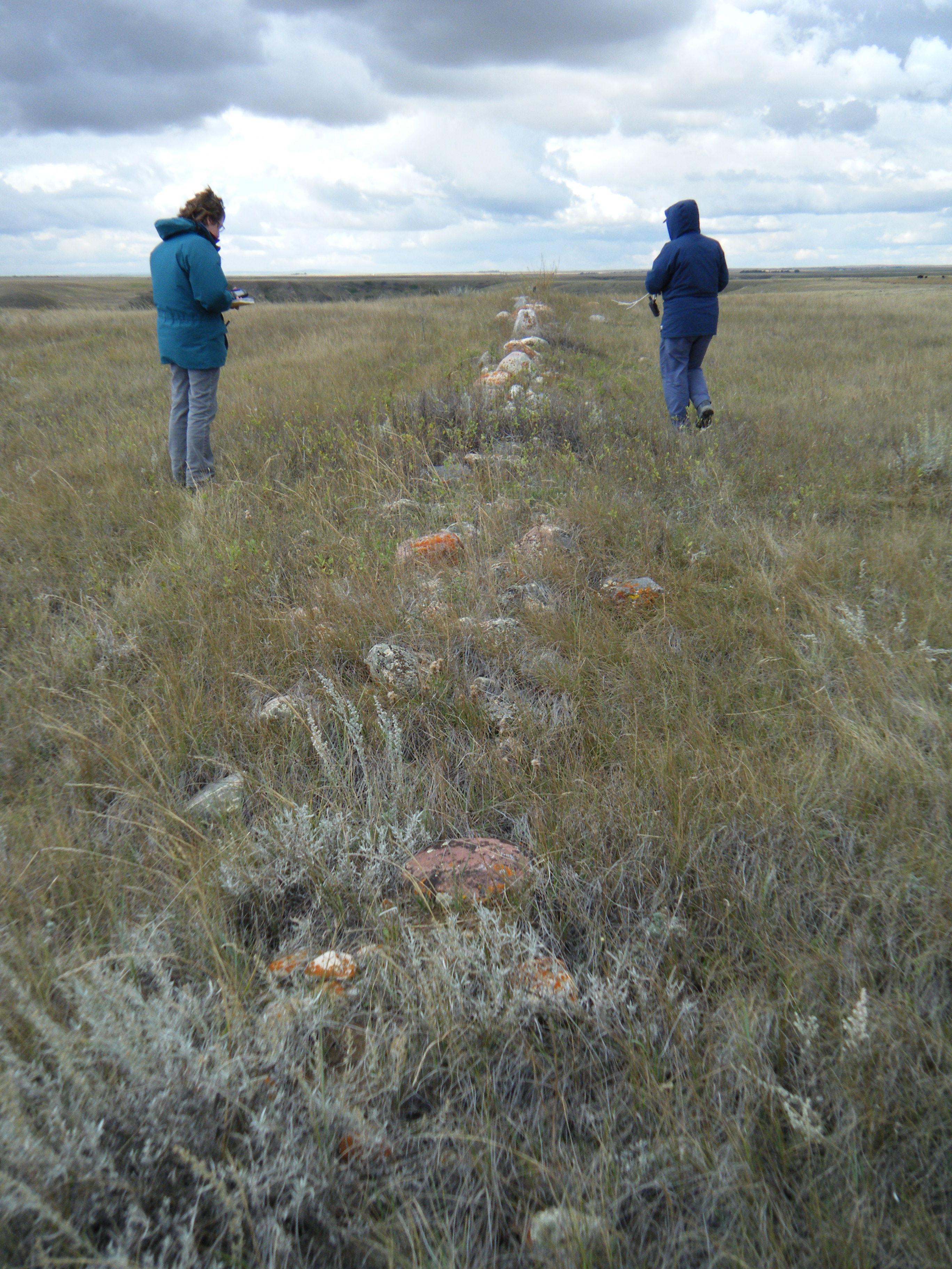
A historic fenceline at Writing-On-Stone Provincial Park being recorded by Alberta Culture & Tourism staff, October 2014. (Photo courtesy of Wendy Unfreed, Plains Archaeologist)
These days the majority of new archaeological sites in Alberta are recorded by historic resource management consultants. Consulting companies are hired by developers in the province to carry out Historical Resource Impact Assessments, which involve the survey and testing of areas that will be affected by a proposed development for the potential or presence of archaeological sites. If a consultant deems an area to be high potential (judged by factors such as landforms, proximity to water bodies, and proximity to known sites, among other things) he or she will conduct surface inspection and possibly shovel testing (digging a hole about 40 cm by 40 cm in size) to search for archaeological artifacts or features.
If results are positive, the information is submitted to the Archaeological Survey and a unique identifier, called a Borden number, is assigned to the site. The Archaeological Survey can then offer protection and management strategies for these sites. This could involve requirements for complete avoidance or excavation of the site prior to development. Archaeological site information is stored in the Alberta Archaeological Sites Inventory, an important resource for historic resource consultants and other researchers. Artifacts recovered from archaeological sites are stored at the Royal Alberta Museum where they are made accessible for research or put on display in one of their exhibits.
Alberta Culture and Tourism staff members Robin Woywitka (Cultural Land Use Analyst) and Todd Kristensen (Northern Archaeologist) recording stratigraphy at an excavated site in the Fort McMurray region, October 2013. (Photo courtesy of Robin Woywitka)
Alberta’s archaeology may not be as visible as in other parts of the world, but we really do have a rich heritage and an abundance of archaeological resources — we just have to work a little harder to find them. It’s incredible what we can learn when we start digging into our past!
Tell us, what’s your favourite archaeology site in Alberta?
Written by: Courtney Lakevold, Archaeological Information Coordinator.
The Archaeological Society of Alberta, incorporated in 1975, is an amateur organization committed to promoting, protecting and preserving Alberta’s heritage. The Society is one of five provincial heritage organizations that receive annual funding from the Alberta Historical Resources Foundation. The Society is currently made up of over 400 members, organised into six centres: Strathcona (Edmonton and area), Bodo, Red Deer, Calgary, Lethbridge and Southeastern (Medicine Hat). Membership in the Society is open to anyone with an interest in archaeology and it provides great opportunities for people of all ages to get involved in actively experiencing, promoting and protecting Alberta’s archaeological resources!
Artifacts brought into a “Stones and Bones” event hosted by the Lethbridge chapter of the ASA, March 2014. Photo courtesy of John Easton.
The Society facilitates public outreach programs and supports archaeological research across Alberta. Its programs include Speaker Series, workshops, fieldtrips, “Stones and Bones” events and an annual conference and general meeting that consists of a full day of speakers, a poster session and a day long fieldtrip. Professionals from the Archaeological Survey of the Historic Resources Management Branch often assist with, and participate in, Society events.
Members of the Strathcona society making their own stone tools at the March 2014 flintknapping workshop. Photo courtesy of Kurtis Blaikie-Birkigt.
Speaker Series takes place from fall to spring and highlight Alberta archaeology through a monthly talk given by a professional archaeologist. The Strathcona centre is currently collaborating with the Edmonton Telus World of Science by offering the Speaker Series in conjunction with the Indiana Jones exhibit! Recent workshops have included flintknapping, artifact casting, historic artifact identification and artifact illustration. These workshops are day long or weekend events that teach people traditional and archaeological skills. The flintknapping workshop is one of the most popular events. Expert flintknappers from across the province and country teach members how to make their own stone tools using traditional methods of striking two rocks together and using antler tines to refine the shape of the tool and its edges. Nothing is more satisfying than being able to craft your own projectile point! “Stones and Bones” events provide a venue where avocational archaeologists, collectors, and the public can bring their artifacts in to be identified by professionals. This often results in valuable archaeological resources being revealed that enhance the archaeological record of the province. Fieldtrips to all types of sites including medicine wheels, effigies, bison jumps and pounds, and ceremonial sites allow an opportunity for Society members to visit archaeological sites and sometimes witness an active excavation.
Members of the Southeastern centre on a field trip to an effigy site in southern Alberta. Photo courtesy of Janice Andreas.
In addition to these programs, the Society provides funding and volunteer assistance to research projects undertaken by centres, educational institutions or individual members that enhance the knowledge and protection of Alberta’s historic resources. This includes archival research, excavation, or the survey of archaeological sites. Recent research this grant program has supported includes mapping of the Glenbow Town and Quarry site by the Calgary Centre, ongoing excavation at a bison kill site in Bodo and a survey of the Forks region in southeastern Alberta by Society members. All of this research has incorporated public participation by welcoming members to lend a helping hand.
Society members volunteering at an active archaeological excavation. Photo courtesy of Janice Andreas.
In addition to hands-on activities, the Archaeological Society of Alberta produces several archaeological publications. The Alberta Archaeological Review, published bi-annually since 1977, provides news of the Society’s activities and a forum for the presentation of archaeological research in Alberta. The Society also publishes archaeological reports and papers and has produced several versions of the popular book “Record in Stone: Familiar Projectile Points from Alberta” which outlines projectile point typology of the province.
Support from the Alberta Historical Resources Foundation makes it possible for organizations like this to carry out their mandates and create new initiatives to engage the public and make our province’s culture and heritage accessible to everyone! The foundation receives money from the Alberta Lottery Fund that is used to provide financial and technical assistance to community based heritage projects including several Provincial Heritage Organizations, like the Archaeological Society of Alberta, that deliver programs and services that document, preserve and present the province’s heritage.
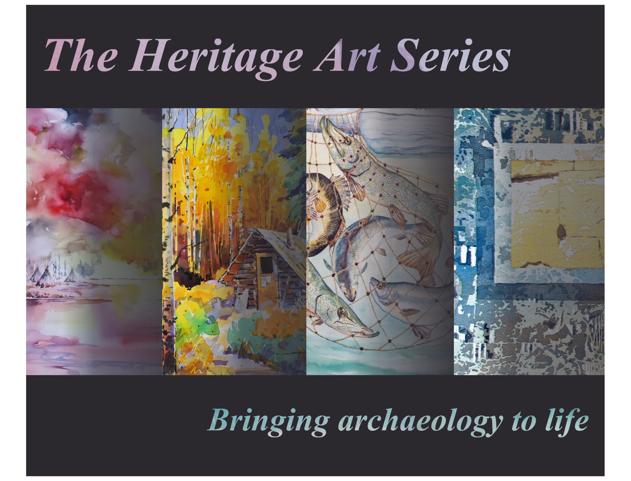
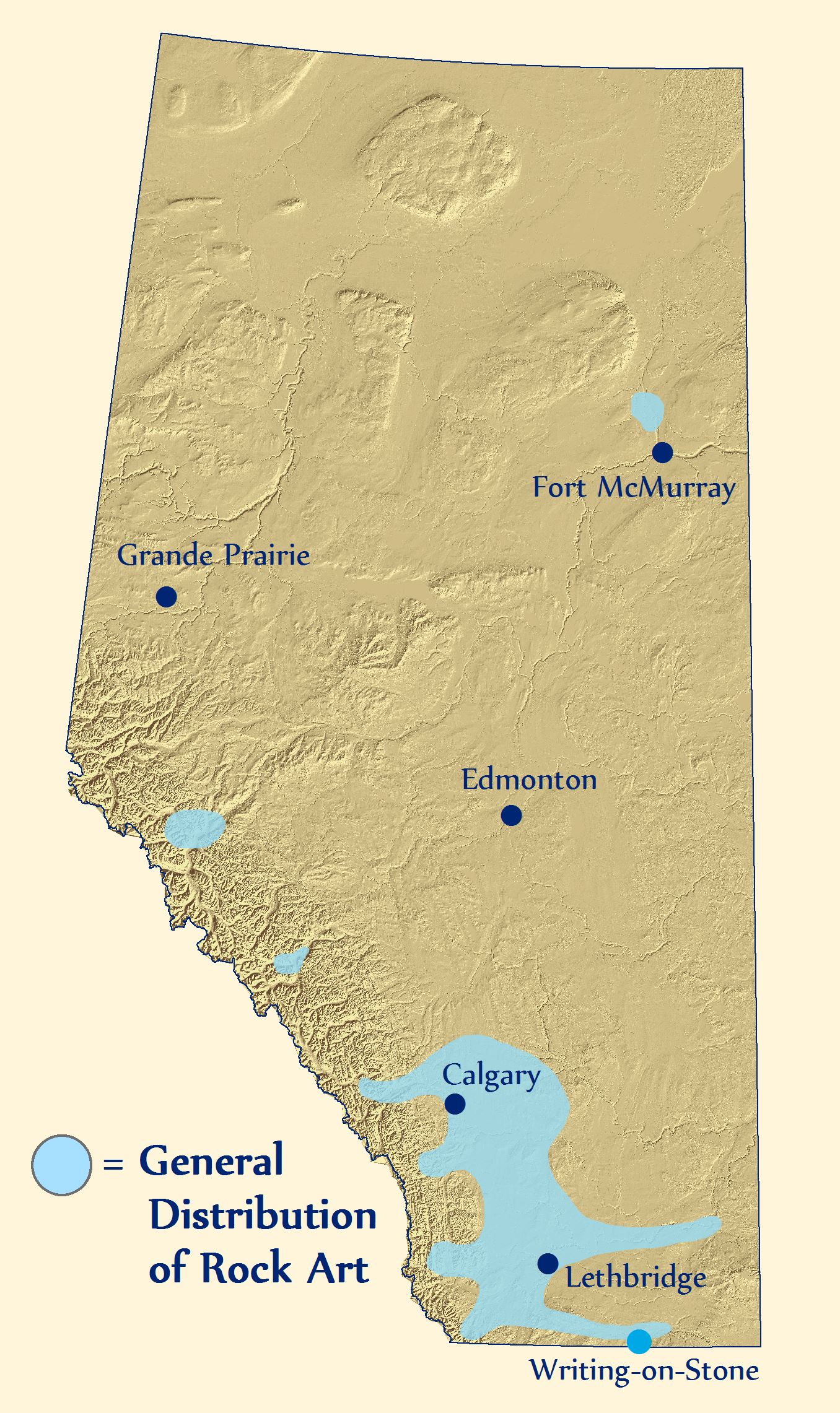
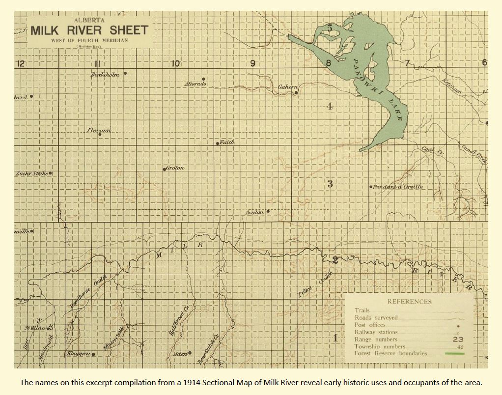
Writing-on-Stone Provincial Park is nestled into the winding valleys and coulees along Milk River in Southern Alberta. Painted and carved on its fragile sandstone walls are one of the largest collections of rock art in North America. Appropriately named, Writing-on-Stone is a rocky canvas of ancient and historic art that spans many centuries.
To increase awareness of this unique piece of the past and to encourage the preservation of sensitive historic resources, a collaborative team of the Historic Resources Management Branch, the Royal Alberta Museum, and the University of Alberta initiated the Heritage Art Series project. The goal is to create artwork, like the piece depicted above, that captivates the public in order to encourage the appreciation and protection of Alberta’s past.
Rock Art in Alberta
Alberta’s rock art includes pictographs (paintings), petroglyphs (engravings), carved boulders, and effigies (rocks arranged to form shapes). Art that was applied to rock walls has a variety of functions and there are six major types in Alberta.
This map depicts the general extent of recorded First Nations rock art in Alberta.
‘En Toto Pecked’ involves figures that were entirely pecked out of the rock wall and this tradition of art appears in Alberta from 2500-1500 years ago. It is thought to have originated in Wyoming.
‘Vertical Series’ may be a type of rock art that acted as a communication system that related events and actors. It may be ideographic (like Egyptian hieroglyphs) with name glyphs like the Mayans of Central America.
‘Columbia Plateau’ refers to vision quest or hunting ritual art thought to be made by people originally from interior B.C. This style of rock art ranges from a few hundred to several thousand years old.
‘Foothills Abstract’ is a rock art style that consists of enigmatic shapes and motifs that may be the work of religious figures. Subjects include handprints, animals (and their tracks), and stylized humans.
‘Plains Biographical’ refers to rock art that documents events, important figures, or tallies of things acquired/exchanged by the Blackfoot and their ancestors.
Lastly, ‘Plains Ceremonial’ refers to spiritually important rock art that is still of great significance to modern Blackfoot Nations. Out of respect for the power of these and other rock art images to modern First Nations, photographs of the various styles of rock art are not included here.
The Milk River Valley Through Time
First Nations pursued buffalo herds in the Milk River region and view the valley as a sacred place where stories and dreams were recorded on the rock walls. The earliest Europeans included a mix of traders, coal miners, and Northwest Mounted Police, the early history of which is still recorded in modern place names.
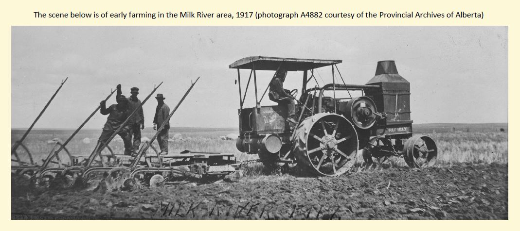
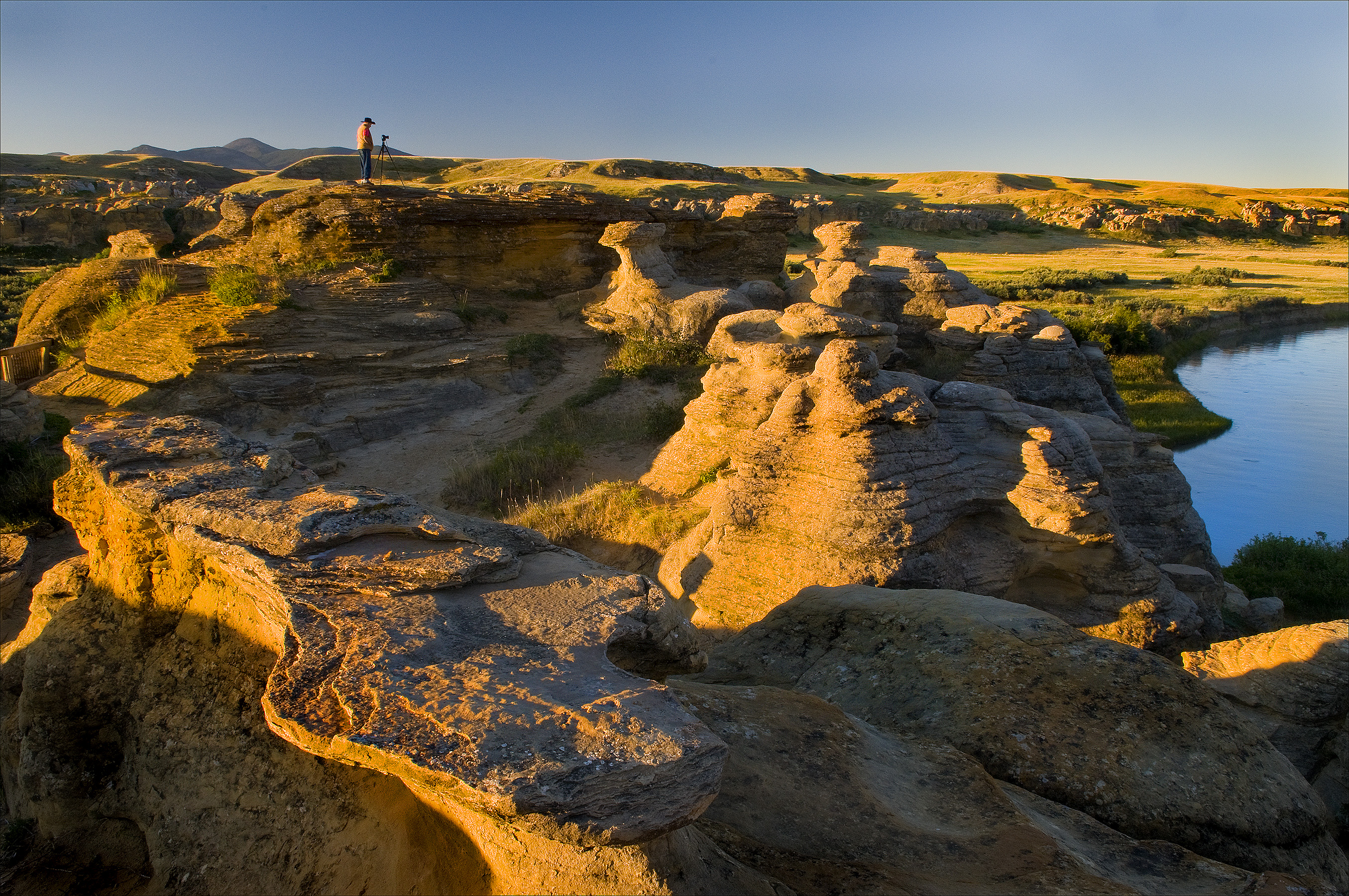
Cattle quickly replaced a vacancy left when buffalo were eliminated in the late 1800s. In addition to ranchers, new irrigation techniques and canals opened up the area to more intensive cultivation. Modern users of the Milk River landscape include farmers, Kainai First Nations, oil and gas operators, ranchers, and people in the tourism industry associated with Writing-on-Stone Provincial Park and National Historic Site (the photograph below is of the morning light on the park’s sandstone hoodoos, courtesy of Robert Berdan). Just as the uses of the Milk River region have changed in the past, they will continue to evolve in the future.
The above painting by Anne McCartney is a textured narrative of landscape change in the Milk River Valley. The background is from an aerial photograph showing irrigated fields creeping to the valley’s edge. At lower right is a looming sandstone cliff that has witnessed a steady flow of First Nations, traders, miners, explorers, and farmers passing through the valley. In the upper left is a rock art panel depicting a battle scene from the deep past. Recent vandalism of that very panel highlights the need to protect and appreciate the landscape of Writing-on-Stone.
Protecting Rock Art Landscapes
The evocative and significant collection of art at Writing-on-Stone is under constant threat. Sadly, vandalism and graffiti have defaced some of the park’s art but through education and restricted access, much of the vandalism has now been curtailed. Instilling visitors with a healthy respect for the spiritual importance of the area to the modern Blackfoot will help ensure that the landscape is protected. Natural erosion, however, is unstoppable.
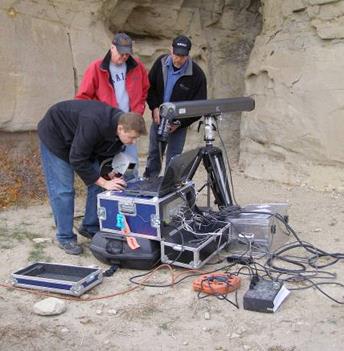
Much rock art has disappeared over the centuries from weathering of soft sandstone. New technologies are helping to better document the art and may lead to long term methods that slow rates of erosion. The park has been a key site in North America for experimentation with techniques to protect rock art.
Archaeologists use laser scanners to accurately record rock art panels.
Portable laser scanners have been used to record high-quality images and to produce near-perfect replicas. Artificial drip-lines and plastic caps are diverting water from some exposed panels and a consolidant has been applied in experimental non-rock art locations to test the ability to strengthen rock and prolong the life of rock art images. Note that none of the preservation measures will be applied directly to ancient images without thorough review and cooperation with the Blackfoot people. Rock art left in its natural setting will eventually be lost, but there is much that can be done to enable a prolonged period of appreciation and enjoyment from viewing the hopes and dreams of early artists.
Written by: Todd Kristensen, Northern Archaeologist, and Jack Brink, Royal Alberta Museum
“Putting dots on paper maps”—that’s how Eric Damkjar, Head of Archaeology at the Archaeological Survey Section of the Historic Resources Management Branch, describes his section’s old methods of recording archaeological site locations. In his words, “We have on record approximately 40,000 archaeological sites … We used to manage that information with hand-drawn dots on paper maps, and that’s a very arduous system.” But about ten years ago the branch obtained funding to create a geographic information system (or GIS) for the information—basically a computerised map”. Damkjar, a former consulting archaeologist who says he’s always had a technical bent, “jumped at the chance” to work on this new initiative.
Embracing technology, particularly GIS mapping, has dramatically changed the way that the Archaeological Survey Section regulates development. Indicating the proposed footprint of the development on a computerised map is much easier and more accurate than the old system of pulling out the relevant paper map and laboriously drawing in the footprint by hand. Also, the electronic footprint provides instant access to a variety of related electronic records that formerly had to be retrieved by hand and reviewed on paper.
The potential of electronic mapping and electronic databases of information go far beyond improving the section’s abilities to regulate development. Paper maps indicating the location of 40,000 historic resources—along with archaeological reports numbering in the thousands—were, as one might expect, extremely difficult to access. When reports only existed in paper form, an individual who wanted to do research had to physically go into the basement and pull a report off the shelf. “Our unit,” says Damkjar, “was basically trying to unlock the vault of archaeological information that was sitting there, tied up in paper, and to make it more accessible [not only for] our … regulatory actions, but also for research.” One goal for 2014 is to create a web portal consisting of a mapping viewer that the public can use to access and view information about archaeological sites.
Damkjar is also eager to make the information that has resulted from the regulation of development more readily available. Every year millions of dollars are spent by industry on archaeological studies, because the Historic Resources Management Branch frequently requires industry to do excavations of sites slated for potential development. Since 1973, there have been approximately 7,000 archaeology projects undertaken in the province. “There’s a valid point in wondering what is the point of excavating these sites if you’re not going to learn anything from it”—in other words, if that information is not going to be made more accessible to the public and to scholars, says Damkjar.
Synthesizing work that has been done by digitizing reports and building databases and electronic maps will help Albertans improve their understanding of the “big picture” of the province’s historic resources. “We can now study the distribution of ancient land use across the province,” says Damkjar. “We can look at where in Alberta different sites are distributed—that used to be very daunting when it was in paper.” The ultimate goal, in Damkjar’s view, is to translate, digest, and synthetize the existing information that the province holds on all its historic resources and in so doing, create a “higher level of understanding” of Alberta archaeology as a whole. Significant progress has been made by staff at the section, who have published books and articles aimed at both amateur and professional archaeologists.
The vision Damkjar has is to “create an environment where we can have dynamic links between archaeological site location information [in GIS] … artifact information, and photographs that are submitted in reports and so on, and create a kind of unified electronic environment where researchers, regulatory people like ourselves, and consultants can work from their desktops and look at the full spectrum of information.” Damkjar notes that “there’s still a lot of work to be done on that front”—but that goal is vastly more achievable now thanks to the evolving technology.
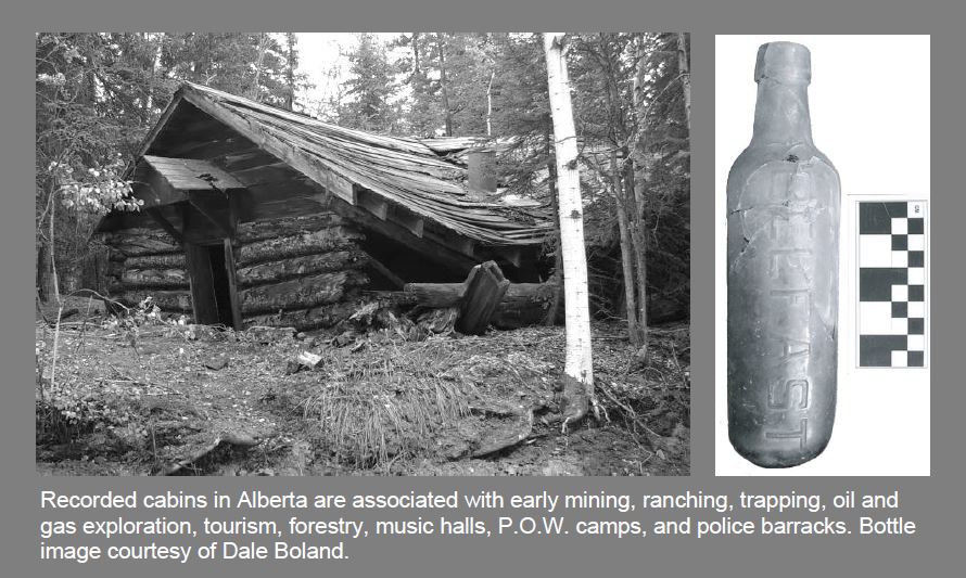
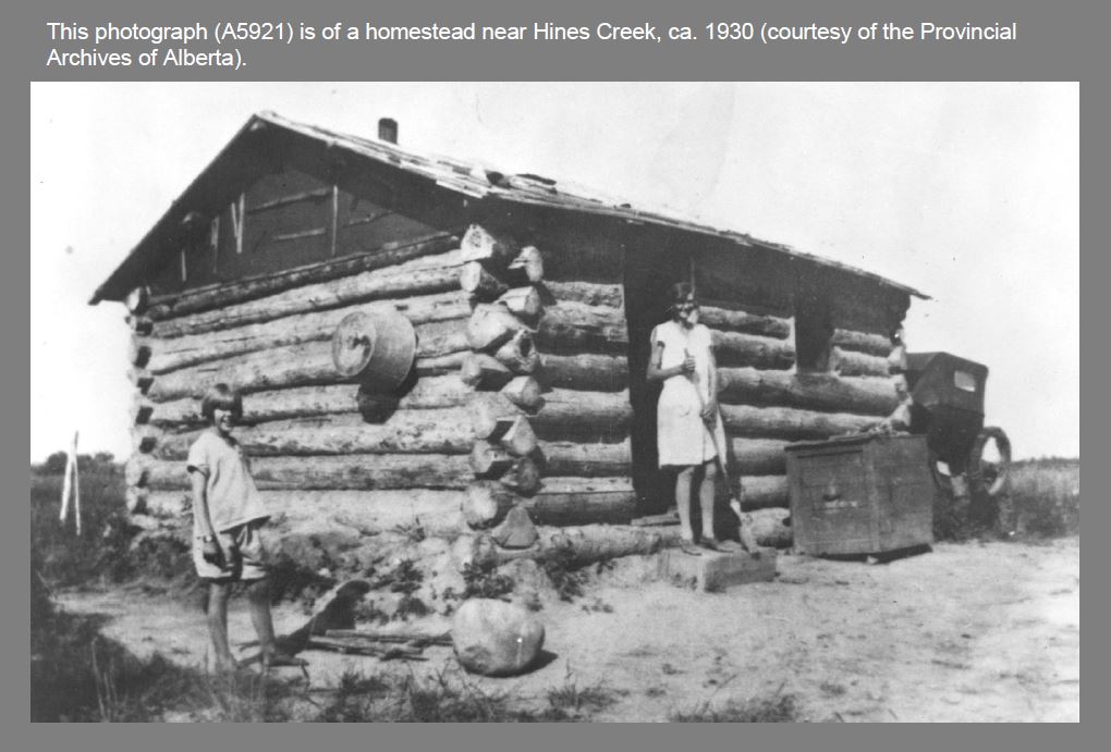
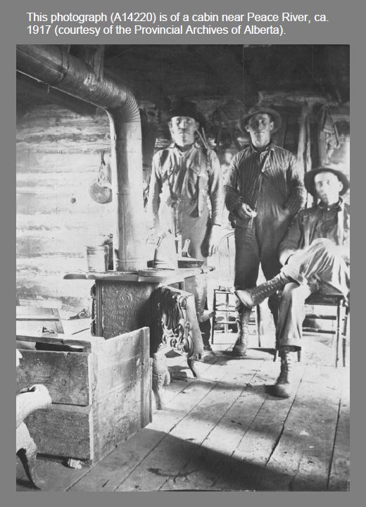
Cabins performed a variety of functions in Alberta’s past from homesteading to hunting and post offices to ranger cabins. Many events and daily challenges that defined our province unfolded on the wooden floors of early cabins. Just like the characters they housed, each cabin’s architecture and associated artifacts are unique.
To encourage an appreciation of cabins and the surviving record of them, as well as other historic resources in the province, a collaborative team from the Historic Resources Management Branch, the University of Alberta, and the Royal Alberta Museum initiated the Heritage Art Series. The goal is to create artworks that depict scenes from Alberta’s past that captivate public audiences. We hope that these artworks, like the cabin painting above, stimulate an interest in learning about our province’s heritage, which will in turn instill a greater respect for the past.
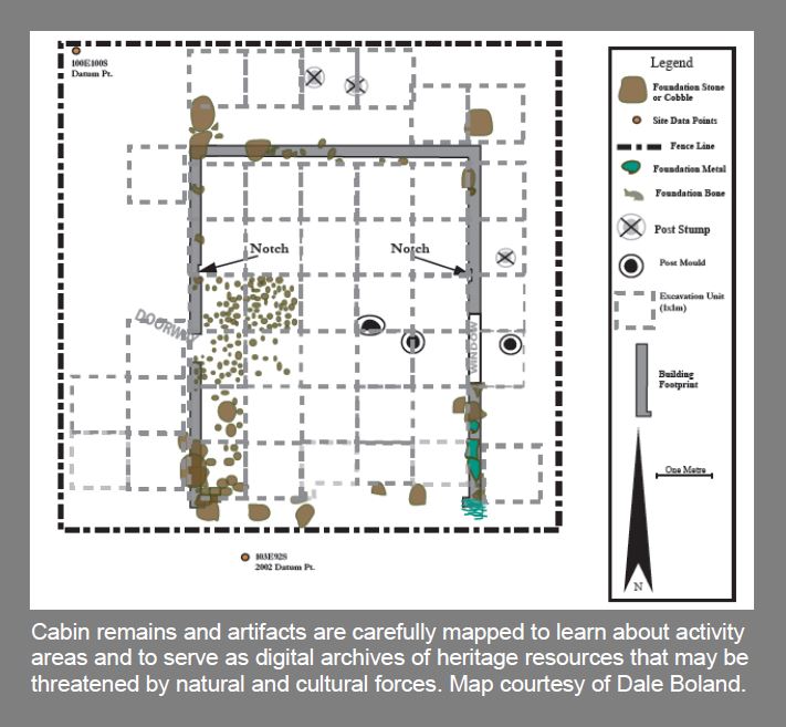
Cabins were typically made of raw timbers with a variety of corner joints, roofs, sawn floorboards, and chimneys. Associated features include outhouses, garbage pits, ice houses (for storing food), cellars, and drying racks. What can the archaeological record tell us about cabins and their occupants? Maps of cabins and associated structures reveal how people utilized landscapes and interacted with each other within cabins. Our modern homes are often relatively large with multiple rooms and levels, which is drastically different from the single-room cabins that many Albertans spent their lives in. An historical perspective informs us that changes in domestic architecture have had a real impact on the way Alberta’s families interact with each other and with their neighbours.
Cabins are often associated with historic trails that influenced how regions were settled and how goods were transported across the country. Cabin modifications over time tell stories of trial-and-error adaptations to new landscapes while artifacts can indicate the types of activities conducted around cabins, cultural affinities, number of occupants, and the season of occupation. Outhouses and garbage pits can reveal past diets, wealth, access to luxury goods, hygiene, medical conditions, and entertainment.
Aside from cabins’ phsycial make-up and artifact assemblages, they are significant heritage resources because they were often the first permanent structures to appear on many of Alberta’s landscapes. They represent a new adaptation and a new way of life for the people who first built them. There are over 550 recorded archaeological sites in Alberta with cabin components. Over 115 of these sites also have a pre-contact First Nations component, which suggests that many of the good spots for cabins have always been good places to make a living on the land.
The painting at the top of this article by Gregg Johnson is of a trapper’s cabin in the autumn foothills. It captures the solitude of the trapper’s life. Autumn was a busy time as trapper’s geared up for winter. Supplies were brought in, trap lines were re-established, and wood was cut for the long winter ahead. Like many of Alberta’s industries, modern trapping has an interesting past and an informative historic record. Archaeology offers a unique opportunity to learn about the past lives of people who may not be represented in historical accounts. In this sense, the study of historic resources gives a voice to people who have not been given the chance to speak for hundreds of years.
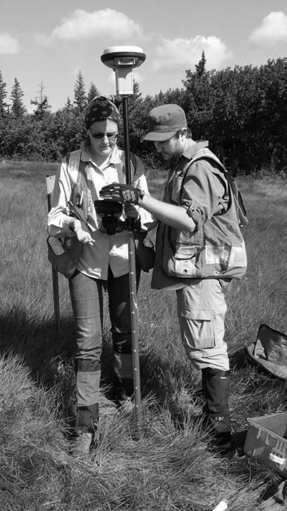
An example of a current research project about cabins that will illuminate the past record of a poorly understood group of people is that by Dr. Kisha Supernant at Buffalo Lake. Dr. Supernant and her research team from the University of Alberta are studying the adaptations of Metis and First Nations people who occupied Buffalo Lake in the 1800s in order to acquire meat that supplied neighbouring trade posts like Fort Edmonton. Her excavations and mapping program will uncover an important way of life that helped shape our province.
Dr. Supernant and a graduate student use GPS equipment to map archaeological features.
The next blog of the Heritage Art Series will be about the changing landscape and rock art of Writing-on-Stone Provincial Park.
Written by: Todd Kristensen, Northern Archaeologist, and Dr. Kisha Supernant, University of Alberta