Over the past few months, some of Alberta’s municipalities have been protecting their built heritage by designating a number of new Municipal Historic Resources (MHRs). These resources are structures and other sites that the municipality has deemed to be of significant heritage value to their community. Like Provincial Historic Resources, municipal designations are listed on the Alberta Register of Historic Places. Municipally designated properties also qualify for conservation grants from the Alberta Historic Resources Foundation.
The City of Lethbridge recently added six new MHRs to the Alberta Register of Historic Places. As of May 31, 2019, the City of Lethbridge has 26 designated MHRs listed.
The most recent listed designations by the City of Lethbridge are:
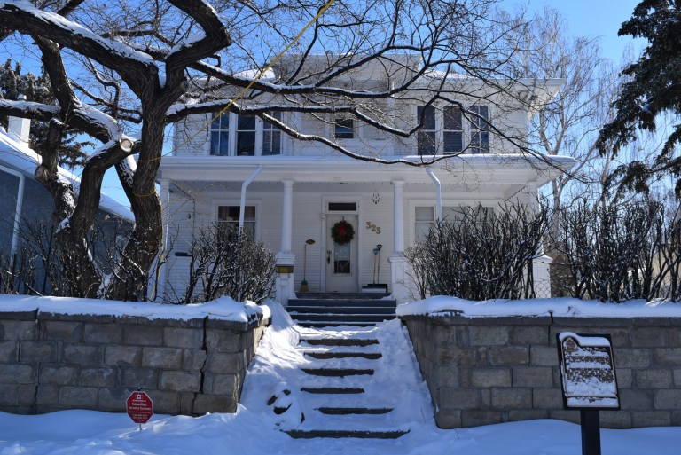
Watson Residence
Located in the Victoria Park neighbourhood on 14th Street South between 3rd and 4th Avenue, the Watson Residence is an Edwardian Foursquare with classical revival detailing and ornamentation. It was built in 1910/11. It has heritage value as an example of residential construction during Lethbridge’s rapid expansion in the pre-First World War period, and as an excellent example of an urban foursquare home. It was also the residence of Allan James Watson, who was a long-serving superintendent of the Lethbridge School District.
Watson Residence, Lethbridge, February 2019. Source: Historic Resources Management, Government of Alberta
Stone tools and debitage, also known as lithics, are one of the most common types of artifacts found in Alberta. In the past, stone tools were an essential part of Indigenous ways of life. These stone tools and associated debitage (pieces flaked off while the stone tool was being manufactured) are made from a variety of stone types, but generally they need to be produced from quality raw materials. The characteristics of a quality raw material for making stone tools include stones that are finer-grained, somewhat brittle and uniform in texture and structure, and have few or no inclusions because these might make the rock break in unpredictable ways. Some of the highest quality material that was used in Alberta in the past comes from other places around North America, such as Knife River Flint from North Dakota, obsidian from British Columbia and the northwestern United States, and other types of cherts, argillites and other materials from neighboring provinces and states. However, several material types are available locally. Some of the most common types available in Alberta include quartzites, siltstones, cherts and petrified wood. In East Central Alberta, a common type of rock utilized by Indigenous groups in the past was pebble chert. There are areas where this stone is readily available and it can be high enough quality to be knapped into tools. While these pebble cherts can sometimes be found today in road cuts or blowouts all across East Central Alberta, there are two pre-contact quarries and associated archaeological sites near Consort, AB where large concentrations of these materials were found, collected and utilized. At these sites, there is evidence that Indigenous groups used rounded and fist-sized pebbles of chert to make stone tools.
The Misty Hills quarry site and complex (Borden block EkOp) is unique because it has large densities of both high quality chert and quartzite pebbles found in more than 130 blowouts across the site. In addition to the raw pebbles, there are many associated quarry Read more →
Written By: Colleen Haukaas (Archaeological Survey)
This week’s post is an update on archaeological project and site data for 2018 from the Archaeological Survey. Click the image below the see the full size.
Disclaimer: the archaeological site counts for 2018 are not final. They are constantly being updated as consultants and researchers submit their reports to the Archaeological Survey.
Written by: Darrin Hagen, legendary playwright, actor, sound designer, composer, performer, director and TV host based in Edmonton
In the tumultuous year of 1969, Canadian queers suddenly found themselves in a new legal landscape. The bill that decriminalized homosexuality passed the parliamentary vote in May – in August, that bill was voted into law. No one was quite sure what it would mean as far as day-to-day life for gays and lesbians, but some forward-thinking folks in Edmonton decided that with this new legal reality, it was time to create Edmonton’s first official queer gathering place.
They chose the name Club 70, even though it was autumn of 1969. Not only was 1969 almost over, but a few of them felt that naming it Club 69 was just a bit too cheeky. And so they heralded the approaching decade by naming the bar with an eye to a new future.
The location was on 101 street and 106 avenue, in the basement of a building that still stands today. Back then, a Greek restaurant occupied the main floor. Even though the Milla Pub is still open, the building is grubby and the yellowing plaster shows neglect. But if you look at the north end of the building, there is a brightly painted door that leads to the basement. It was behind that door that a queer person would nervously descend down the stairs into the very beginnings of Edmonton’s very first official gay club.
You may know it now as the seedy Milla Pub. But behind these doors in 1969, a queer person would nervously descend down the stairs into the very beginnings of Edmonton’s very first official gay club, Club 70.
There had always been places where the Friends of Dorothy could discretely congregate – generally in one corner of the taverns that occupied the main floor of the large, grand hotels that dominated downtown: The Mayfair, The Corona, The Royal George, and the King Edward (or King Eddie). But these gay hangouts were never official – they just sprung up out of necessity in cities across Canada. It was in these early unofficial gathering places that ‘the community’ began to recognize each other in the smoky half-light, and began to connect and communicate. Even as recently as the early 80s, a gay man could stroll into one of these smoky taverns, and once his eyes adjusted to the darkness, he could find a group of men like him, taking over one corner or certain tables in the room.
None of these hotels stand today – they’ve been replaced by downtown malls, or newer high-rises. Only the Corona LRT station keeps one of those names alive. But somehow the early gay club scene’s first legal footprint has escaped the wrecking ball of progress.
Through those nondescript doors, one descended down a flight of stairs into a space no bigger than a large living room. Everyone had to sign in, although pseudonyms were the norm – people were still very afraid to be ‘outed’ and the last thing one would want was to be identified by logging into a register of a gay bar. There was hired security – a straight man who kept a scowling presence at the bottom of the stairs.
Small stage for burgeoning drag scene
The club had no liquor license, and so bringing your own bottle was essential, as the concession only sold pop and chips. There was a small dance floor, and even a tiny stage populated by the pioneers of Edmonton’s burgeoning drag scene: Grindl performed on that stage, as did Trixie, and Millie – names that, within a few years, would become legend on the stages of the underground. Few Queens were as legendary as Millie, who in 1976 would become Edmonton’s first crowned head of state, the unofficial Godmother to all Queens who followed: Empress I of Edmonton, establishing the Imperial House of Millicent, the first in a long chapter of royal houses that still rules Edmonton through the auspices of the Imperial Sovereign Court of the Wild Rose; she was simultaneously crowned Mz. Flashback I. Millie has the distinction of being the only drag queen in Edmonton’s history who wore both crowns at the same time.
The tiny club could only hold about 50 people, and was only open on Friday and Saturday nights. The ambiance was more like a house party than a nightclub. But it was the first queer space. That meant safety. It meant being able to freely recognize and acknowledge people like yourself, to dance with whoever you wanted to dance with, or to freely cheer on a drag show.
That freedom was fiercely protected, however. Club 70 had a strict gay-only membership policy, for the safety and discretion of its members. Violating this policy by bringing a straight person to the bar would get you a 30-day suspension.
Club 70 bears the distinction of being the first official, registered-on-paper-with-city-hall, gay society in Alberta
However, it got off to a very rocky start. The location was short-lived, even though Club 70 was not. After a month of weekends of business, the owner of the building finally realized what sort of business had taken root in his basement, and when staff and members arrived for the weekend party, they found he had nailed the doors shut, seized the liquor, and whatever there was in the way of a sound system. The fledgling gay club was suddenly in a legal battle with a landlord. However, they won that battle, as their lease had been broken illegally, and were able to not only get their stuff back, but the owner of the building was forced to pay for their relocation costs.
Club 70 closed for a month, eventually finding a new home on 106 street; that building remained queer for the next 42 years. When Club 70 had run its course, it transformed into The Cha Cha Palace for a short period in 1978, then Boots & Saddles for decades, and lastly The Junction Bar & Grill. Once the 106 street location opened, that spot in Edmonton was a safe queer space from 1970-2012.
In 1969, the first step towards building a new sense of community was building a home; a meeting place or a town square, where LGBTQI people could gather, and for the first time, discover who they were in this brave but unknown new world.
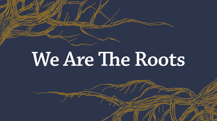
Winner of the 2018 Alberta Historical Resources Foundation 2018 Heritage Awareness award, We Are the Roots is a documentary that tells the stories of African American immigrants who settled in Alberta and Saskatchewan in the early 1900s.
In the film, you’ll hear stories from 19 descendants of original settlers, as they moved north to escape slavery, persecution and racism in America. Once in Canada, these families would then experience more discrimination, both in Edmonton and in rural communities they settled.
The film was produced and created through a partnership between documentary film production company Bailey and Soda Films along with Edmonton’s Shiloh Centre for Multicultural Roots,
Click the image above to view the full-length documentary.
Editor’s note: This article was originally published in The Yards Magazine in September 2018. It has been reprinted here with the author’s permission.
On May 12, 1922, Lulu Anderson tried to buy a ticket to ‘The Lion and The Mouse’ at the former Metropolitan Theatre on Jasper Avenue. Lulu was 36 and a member of the Black community. She enjoyed the theatre and had visited the Metropolitan many times with her friends. But May 12 was different. The theatre staff denied Lulu entry. Worse, they “assaulted” her, according to a column in the Edmonton Journal.
Lulu decided to stand up.
Few Edmonton residents know Lulu’s story. And to understand what happened to her downtown that night, in 1922, we need to back up a bit. For starters, despite many who still believe the opposite, Alberta was home to anti-black racism. Minstrel shows were extremely common in theatres; indeed, actors of the era routinely performed in blackface. In 1920, a minstrel parade was even held downtown. Segregation was also common across the city. From 1910 to 1950, Black Edmontonians were denied entry into theatres, swimming pools, bars and even hospitals. One more well-known example is from 1938, when a Black nurse was denied entry into nursing training at the Royal Alexandra Hospital.
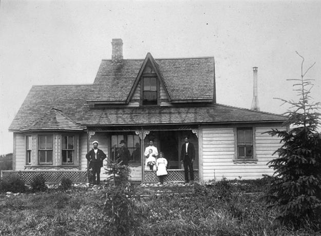
Author note: Five years ago, I visited Iceland and it sparked an excitement I thought could not be experienced anywhere else in the world. This was until a summer road trip to the hamlet of Markerville, an Icelandic settlement in Red Deer County. Historic Markerville is home to the Icelandic-Canadian Markerville Lutheran Church, Markerville Creamery, Fensala Hall and the Stephansson House Provincial Historic Site.
Stephansson House in Markerville. Image courtesy of the Provincial Archives of Alberta, A5007.
The Icelandic-Canadian, Stephan G. Stephansson, led a fascinating life. He was an immigrant, farmer, father and most notably a poet. In Icelandic and Icelandic-Canadian communities, Stephansson’s poems are well known for their evocative images of landscapes and homesteading as well as passionate portrayals of his personal beliefs and philosophies. In search of a better life, he came to Alberta and settled in the Markerville area, along with fifty other Icelanders.
Editor’s note: The following blog post is part one of a two-part series looking at the history and influence of Doukhobors in Alberta.
East of the Crowsnest Pass, nestled within the small community of Lundbreck, sits a simple white building clad in asbestos shingles and covered with metal roof. The structure looks utilitarian and spare; it could easily be mistaken for the kind of modest community halls one occasionally sees in Alberta’s small towns. While the building is almost entirely non-descript, the history that it embodies is extraordinarily rich.
The history of the Alberta Doukhobors is an essential chapter in the story of one of the largest experiments in communal living in North America. Approximately 7,500 Doukhobors came to Canada in 1899, at the time it was the largest mass migration in the country’s history. In stark contrast, at a 2018 meeting of Doukhobors in British Columbia, a grim question was posed: will there be any Doukhobors active in their faith by 2030? Between their noteworthy arrival at the end of the nineteenth century and their dwindling membership today, the Doukhobors have lived a tumultuous and compelling experience in Canada. This post attempts to explore the vision and roots of the Doukhobor community, and their early experiences in Canada.
The Doukhobor Prayer Home in Lundreck (also known as the Doukhobor Hall [dom or house]) is one of the few tangible reminders of one of the most remarkable communities of people to ever settle in this province.Read more →
For the past few years, I have committed, heart, body and soul to the pursuit of my graduate degree in archaeology. I know many people in pursuit of their degrees would choose to study a fascinating subject, with the potential to change the world; but being the go-getter that I am, I chose the blood-racing world of dental microwear analysis. My focus, specifically, was in applying the study of dental microwear to bison from sites in southern Alberta to determine which seasons those sites were occupied (the site’s seasonality).
Albus, helping me observe the seasonal trends in grass growth on one of my regular visits to Glenbow Ranch Provincial Park.
What is dental microwear?
The analysis of microscopic patterns on teeth has been useful to several fields, including archaeology. The method can provide information about an animal’s diet immediately before death, allowing researchers to reconstruct past environments and determine the season that an animal died. This is based on the recognition that different types of food produce identifiable features on the enamel of teeth.
In faunal archaeology, the most common distinctions made based on microwear are between herbivores who either graze or browse. Grazing animals that mainly eat grasses and other low-lying plants, such as cattle, tend to use a grinding motion when chewing, which drags food across the enamel. This produces features Read more →
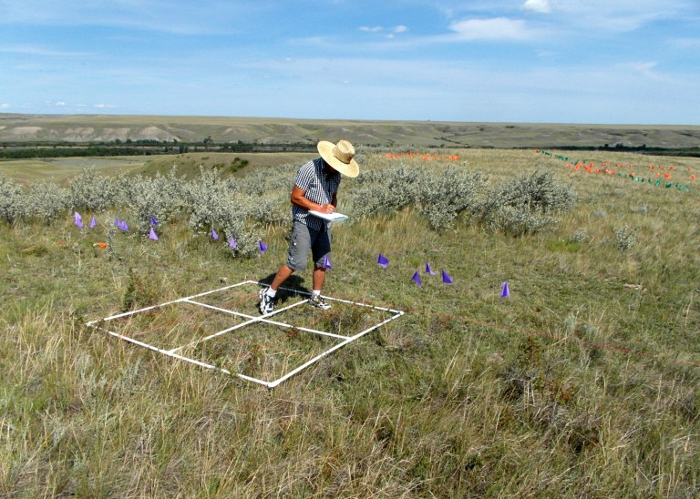
Field assistant mapping a medicine wheel. Purple and green flags mark spokes, orange flags mark cobble rings.
Often, archaeological discoveries are thought to only result from physical archaeological surveys. However, later data analysis and computer modeling can also provide important insights not easily seen in the field. Recent efforts to reconstruct possible past travel routes along the Red Deer River north of Brooks help illustrate just such a situation. Exciting archaeological finds were made, both through traditional archaeological survey techniques in the field, as well as with modern computer modelling approaches later in the office. These finds highlight the importance of viewing the past not simply as a series of isolated archaeological sites, but rather as a continuous cultural landscape.
Two seasons of fieldwork, consisting of more than 400 km of pedestrian survey, were conducted along the edges of the Red Deer River valley for some 43.5 km of the river’s course. The area was situated in some of the warmest and driest parts of the province, with vegetation consisting primarily of grasses, a few shrubs and vast swaths of prickly pear cactus. While some portions were virtually devoid of vegetation, unusually high amounts of precipitation throughout the region had encouraged thick grass growth in most other areas, and had kept the prairie a rich green colour for much longer than usual. Hidden within that thick cover of grass were large numbers of archaeological cobble features – the location of close to 1,000 of which were recorded with GPS. Unsurprisingly, the vast majority of features recorded during the fieldwork were standard cobble rings that marked the locations of past tipis. Also recorded, however, were significant numbers of other types of cobble structures, like standard cobble cairns and cobble arcs, as well as more unusual features , like tailed cobble rings, hollow cairns, and medicine wheels.
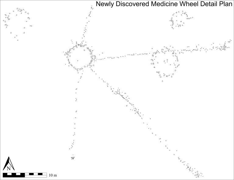
Southern Alberta is home to a greater number of medicine wheels than any other jurisdiction, and the Red Deer River appears to be a particularly rich location for them. Image provided by Terry Beaulieu.
A total of five known medicine wheels were located in the area. Due to land access issues, however, only two of the five were visited during the present investigation. One new medicine wheel, though, was discovered. Like the other five medicine wheels in the vicinity, the newly discovered medicine wheel lies quite close to the valley edge, overlooking the Red Deer River to the east. It has a very well defined 5.25 m diameter central cobble ring from which four less-well defined linear cobble spokes radiate. The three longest spokes each terminate at a cobble cairn. A cobble ring is bisected along its northern edge approximately midway along the east northeast running spoke and a tailed cobble ring, along with a standard cobble ring, lie close by.
The wealth of locational data collected for the recorded cobble features was critical to computer analyses later conducted in the office. Close to 1,000 data points – the locations of archaeological cobble features – were imported into a geographic information system (GIS) to form the basis of a sophisticated spatial modeling analysis. Archaeological applications of GIS have often been criticized for placing too much emphasis on the physical environment and of therefore being guilty of excessive environmental determinism. The modelling approach taken in this study was designed to intentionally emphasize cultural elements in order to address such concerns with what is generally considered to be a landscape archaeological approach.
One of the ways cultural elements were emphasized was through identifying and integrating the concept of place into the GIS analysis. Incorporating locations into the GIS that had been identified based on place names known to have been used by Indigenous people was one such method employed. Past places were also determined by using the archaeological information collected in the field. Locations indicative of important places, for example, were identified by locating significant concentrations of standard cobble rings, or finding the presence of known ceremonial features such as medicine wheels and hollow cairns, among others. GIS modelling was then conducted in an effort to locate and model pedestrian travel routes that may have been employed by past people during their summer travels through the region when heading to the nearby important location of Hunting Hill.
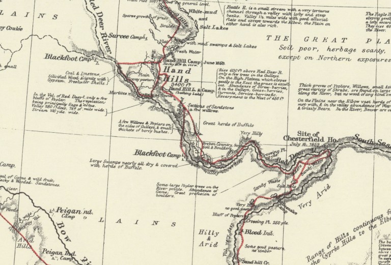
A segment of Palliser’s 1865 map showing the route he travelled (marked in red) down Bullpound Creek and across the Red Deer River when visiting a Blackfoot Camp. Provided by Terry Beaulieu.
The GIS models indicated a crossing point located near where Bull Pound Creek empties into the Red Deer River. The problem, however, was that most early maps of the area indicated the closest known river crossing was upstream from there at Lord Lorne Crossing. It therefore appeared the GIS models were flawed. Further investigation, however, revealed that was likely not the case.
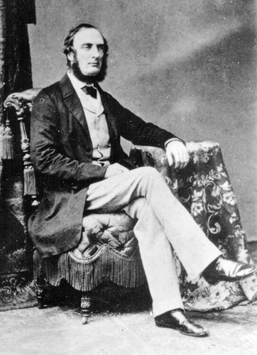
In the summer of 1859, Captain John Palliser travelled through the region as part of his multi-year expedition through western Canada. He was one of the first Europeans to visit the region and the maps he produced are some of the earliest created of the area. During those travels he wrote of visiting “Blackfoot Indian” camps. The route he travelled during one of those visits ran down the east side of Bull Pound Creek and crossed the Red Deer River at the point where the creek emptied into the river – at almost the exact location indicated by the GIS models. Given that Palliser was likely being guided by residents of the camp, who would have been familiar with the best routes and river crossings, the concurrence between Palliser’s map and the GIS models indicates the modelling process was indeed successful in identifying the location of a river crossing point used by past peoples.
Captain John Palliser was one of the first Europeans to visit western Canada and the maps he produced are some of the earliest created of the area. Source: Wiki Commons
It is interesting to note that less than a quarter century later, when George M. Dawson, of the Geological Survey of Canada, created his maps of the area, the crossing near the mouth of Bullpound Creek was no longer recognized by those creating the maps. Lord Lorne Crossing, significantly upstream from the mouth of Bullpound Creek, had instead replaced it as the important crossing place. Such a shift illustrates how quickly changes occurred on the prairies in the mid to late 1800s, and how fast Indigenous information became lost and undervalued during European map making. Information about the locations of significant places to past people does not have to remain lost and forgotten, though, and can be resurrected through thorough investigation and careful research, as is evident by the discovery of a previously unknown medicine wheel and the identification of a forgotten river crossing. Both are significant additions to the archaeological record that, in addition to helping inform our understanding of the past, also show that important new archaeological discoveries are still being made, whether through old fashioned archaeological legwork or modern computer analysis.
Written by: Terry Beaulieu, Ph.D. Graduate, University of Calgary